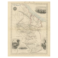
Items Similar to Crossroads of Empires: A John Tallis Map of the Isthmus of Panama, 1851


Want more images or videos?
Request additional images or videos from the seller
1 of 7
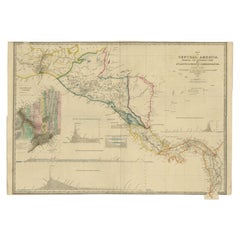
Crossroads of Empires: A John Tallis Map of the Isthmus of Panama, 1851
$277.62
$347.0320% Off
£207.35
£259.1920% Off
€232
€29020% Off
CA$382.47
CA$478.0920% Off
A$416.83
A$521.0420% Off
CHF 220.73
CHF 275.9120% Off
MX$5,006.56
MX$6,258.2020% Off
NOK 2,794.48
NOK 3,493.1020% Off
SEK 2,569.25
SEK 3,211.5620% Off
DKK 1,767.44
DKK 2,209.3020% Off
About the Item
The Tallis map of the Isthmus of Panama is a beautifully detailed work, characteristic of the maps produced by John Tallis
Company, which was one of the last cartographic firms to decorate their maps with such intricate illustrations. John Tallis is known for his highly decorative maps of the 19th century, which were designed not only for practical use but also as works of art.
**The Maker - John Tallis
Company:**
Tallis maps are appreciated for their elaborate borders and vignettes which make them stand out as a cartographic treasure. The company’s work is a reflection of the Victorian era's tastes and interests and is sought after by collectors for both its aesthetic and historical value.
**The Map - Isthmus of Panama:**
The map would be a detailed portrayal of the Isthmus of Panama during a time when the region was under significant scrutiny for its potential to connect the Atlantic and Pacific oceans—eventually leading to the construction of the Panama Canal in the early 20th century. During Martin's time, the area would be vital for global trade and navigation, hence its detailed cartography by the British.
**The Countries:**
During the time of this map's production, Panama would be part of the Republic of New Granada. It later became part of Colombia and eventually its own nation in the early 20th century. The map's detail would be essential for explorers, merchants, and political interests of the era.
**The Images on the Map:**
The illustrations typically featured on Tallis maps include key landmarks, economic activities, and local scenes. On this map of Panama:
- **The Fort at Chagres**: A strategic colonial-era fortress is prominently displayed. Chagres was crucial because of its position on the Chagres River, which was part of a transisthmian route used by the Spanish to transport gold and other goods.
- **Gold Seekers of 1849 Crossing the Chagres River**: This vignette illustrates the reality of the California Gold Rush era, where many traversed the Isthmus of Panama as a shortcut between the east and west coasts of the United States.
**The Tallis Series:**
Maps from "The British Colonies" by Robert Montgomery Martin were often included in atlases intended for a British audience eager to see the reaches of their empire and the various lands across the globe that were under British influence or of interest to British expansion.
This map is a fine example of the intersections between art, cartography, and history, and it provides a rich visual and geographical perspective on an area of significant historical importance.
- Dimensions:Height: 10.71 in (27.2 cm)Width: 14.26 in (36.2 cm)Depth: 0 in (0.02 mm)
- Materials and Techniques:
- Period:
- Date of Manufacture:1851
- Condition:Good given age. Original fold in middle as published. General age-related toning, please study scan carefully.
- Seller Location:Langweer, NL
- Reference Number:Seller: BG-13736-31stDibs: LU3054339291412
About the Seller
5.0
Recognized Seller
These prestigious sellers are industry leaders and represent the highest echelon for item quality and design.
Platinum Seller
Premium sellers with a 4.7+ rating and 24-hour response times
Established in 2009
1stDibs seller since 2017
2,788 sales on 1stDibs
Typical response time: <1 hour
- ShippingRetrieving quote...Shipping from: Langweer, Netherlands
- Return Policy
More From This Seller
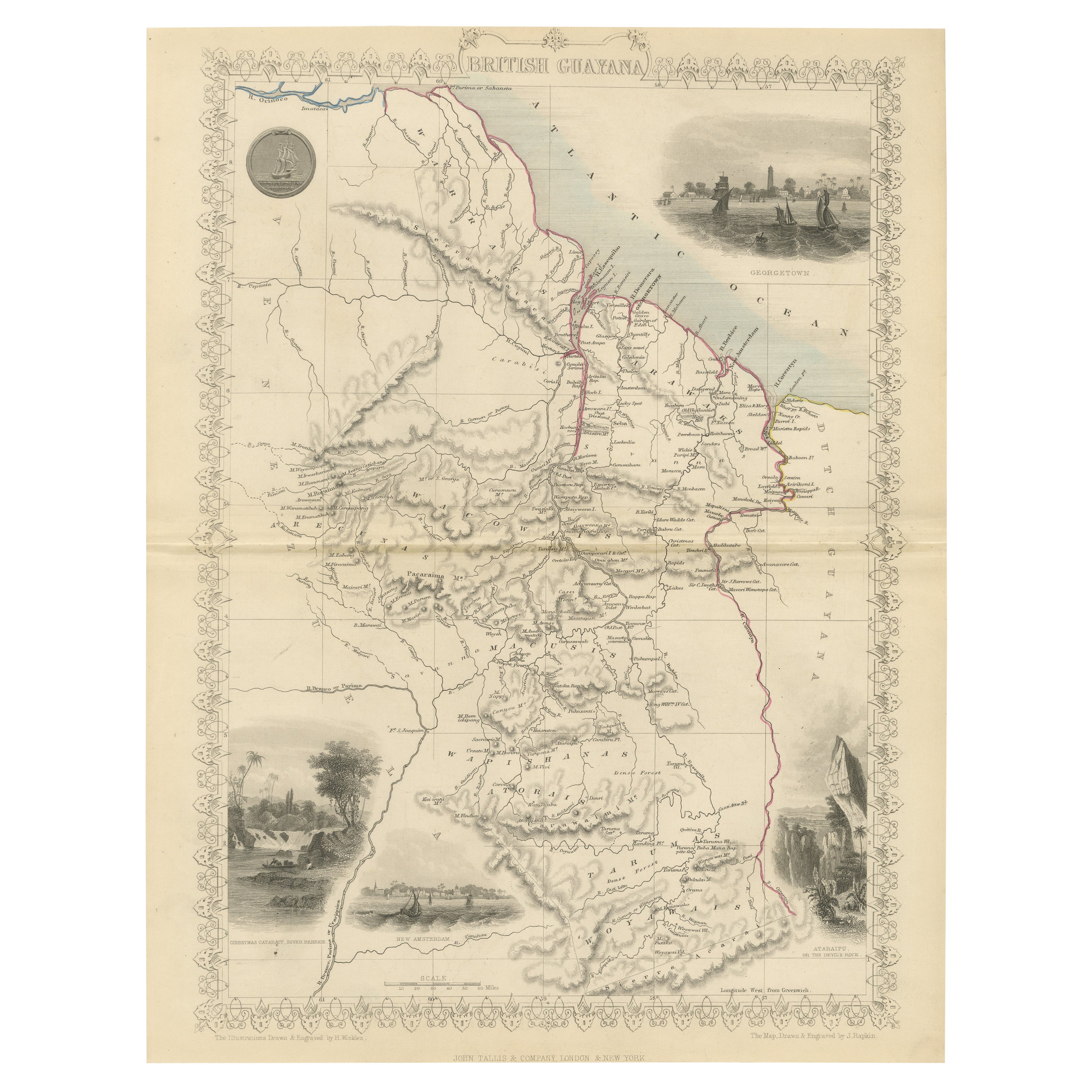
View AllA Tallis Map of British Guiana with Colonial Vignettes and Other Landmarks, 1851
Located in Langweer, NL
This Tallis map of British Guiana (now known as Guyana) is a richly decorated document, much like other maps from the esteemed cartographic publisher John Tallis & Company. The firm,...
Category
Antique 1850s Maps
Materials
Paper
$277 Sale Price
20% Off
Antique Map of Central America Showing the Communication Lines, 1850
Located in Langweer, NL
Antique map titled 'Map of Central America Shewing the Different Lines of Atlantic & Pacific Communication'. A most unusual U.S. Government edition of this handsome map of Central Am...
Category
Antique 19th Century Maps
Materials
Paper
$1,675 Sale Price
20% Off
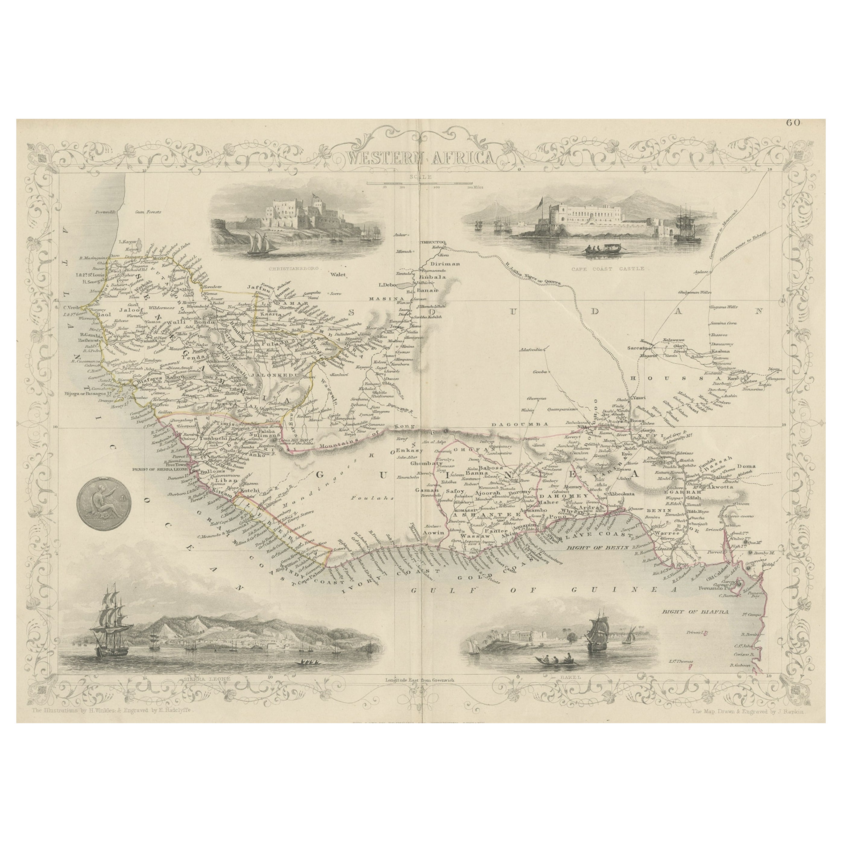
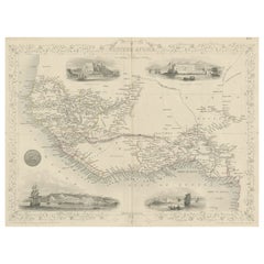
Antique Map of Western Africa with Vignettes of Cape Coast Castle etc, ca.1851
Located in Langweer, NL
Antique map titled ‘Western Africa’. Includes decorative vignettes titled Christiansborg, Cape Coast Castle, Sierra Leone and Bakel. Originates from 'The Illustrated Atlas, And Modern History Of The World Geographical, Political, Commercial & Statistical, Edited By R. Montgomery Martin'. Published; John Tallis London, New York, Edinburgh & Dublin. 1851. Drawn and Engraved by J. Rapkin.
Artists and Engravers: John Tallis (1817-1876) was a British map...
Category
Antique 1850s Maps
Materials
Paper
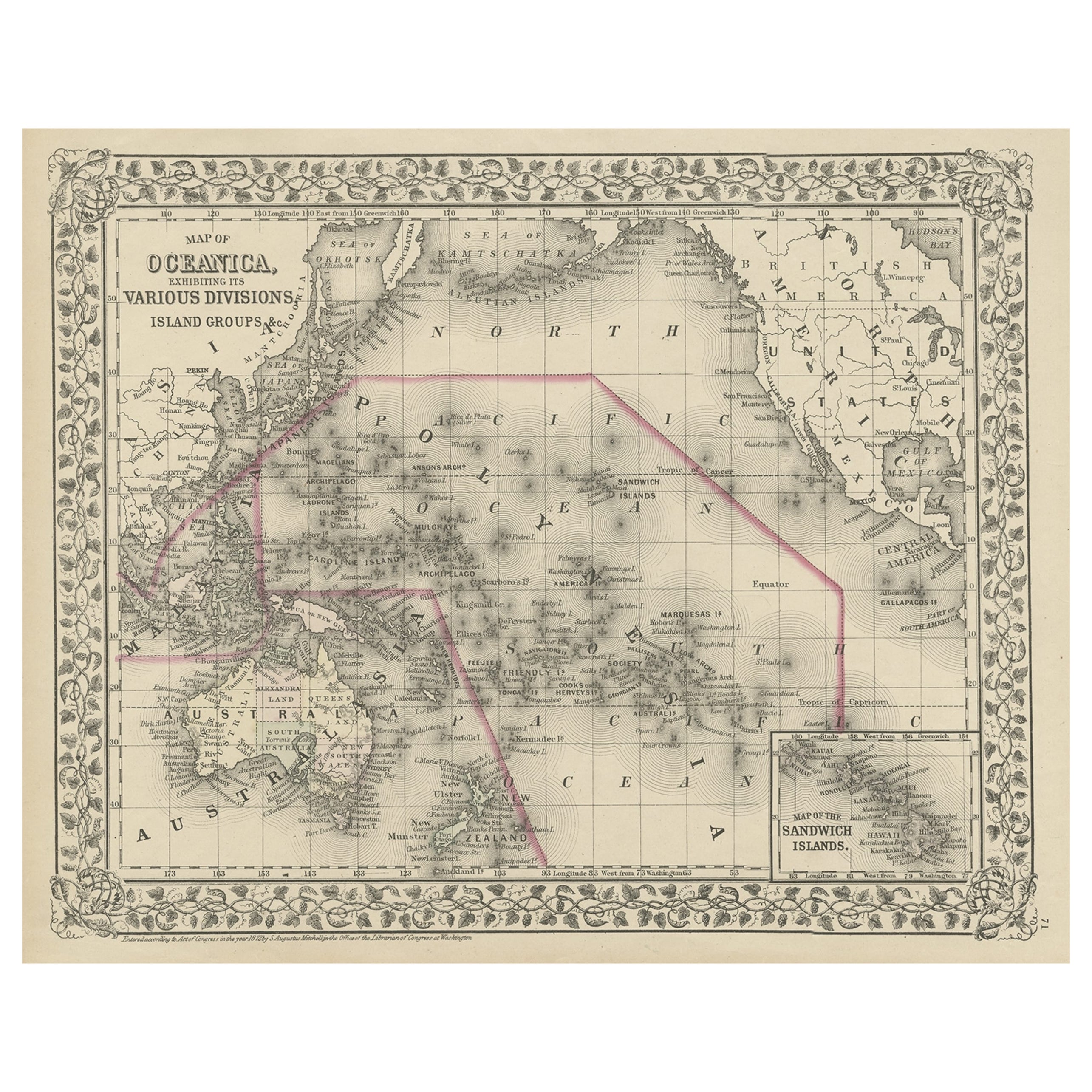
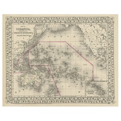
Old Map of the Pacific, Incl Australia, Polynesia, Melanesia and Malaysia, 1872
Located in Langweer, NL
Antique map Oceania titled 'Map of Oceanica exhibiting its various divisions, island groups & c'.
Map of the Pacific, including Australia, Polynes...
Category
Antique 1870s Maps
Materials
Paper
Antique Map of the Northern Part of South America by J. Tallis, circa 1851
Located in Langweer, NL
A decorative and detailed mid-19th century map of the northern part of South America (including modern day Venezuela, Colombia, Ecuador, Guyana, Suriname and French Guiana) which was drawn and engraved by J. Rapkin (vignettes by H. Winkles & W. Lacey) and published in John Tallis & Co.'s The Illustrated Atlas (London & New York: circa 1851).
The Illustrated Atlas, published from 1849 onwards, was the last decorative world atlas. The 'Venezuela, New Granada...' map was typical of the many Fine ones which appeared in this work with its decorative border and attractive vignettes. Illustrated are views of Mount Chimborazo, Ecuador; the 'Fall of the Bagota' (Tequendama Falls, Colombia); Rheas and a prospect of Paramaribo Harbour (Dutch Guiana...
Category
Antique Mid-19th Century English Maps
Materials
Paper

$263 Sale Price
20% Off
Antique Map of the West Indies and Central America by W. G. Blackie, 1859
Located in Langweer, NL
Antique map titled 'The West India Island & Central America'. Original antique map of the West Indies and Central America, with inset map of Jamaica. Th...
Category
Antique Mid-19th Century Maps
Materials
Paper

$239 Sale Price
20% Off
You May Also Like
Original Antique Map of Central America / Florida, Arrowsmith, 1820
Located in St Annes, Lancashire
Great map of Central America.
Drawn under the direction of Arrowsmith.
Copper-plate engraving.
Published by Longman, Hurst, Rees, Orme and Brown, 1820
Unframed.
Category
Antique 1820s English Maps
Materials
Paper

Central America. Century Atlas antique vintage map
Located in Melbourne, Victoria
'The Century Atlas. Central America.'
Original antique map, 1903.
Inset maps of 'The Country around Lake Nicaragua'.
Central fold as issued. Map name and number printed on the reve...
Category
Early 20th Century Victorian More Prints
Materials
Lithograph

1847 Antique Map of Mexico, Texas and California by Samuel Augustus Mitchell
By Samuel Augustus Mitchell 1
Located in Colorado Springs, CO
Presented is the second edition of Samuel Augustus Mitchell's Map of Mexico, Including Yucatan & Upper California, an important map showing the progress of the Mexican-American War. ...
Category
Antique 1840s American Maps
Materials
Paper

Original Antique Decorative Map of South America-West Coast, Fullarton, C.1870
Located in St Annes, Lancashire
Great map of Chili, Peru and part of Bolivia
Wonderful figural border
From the celebrated Royal Illustrated Atlas
Lithograph. Original color.
Published by Fullarton, Edi...
Category
Antique 1870s Scottish Maps
Materials
Paper

Map Of The Island Of Cuba - Guillaume Thomas Raynal (1711-1796)
Located in Porto, PT
This historical map of the Island of Cuba was produced in the late 18th century and is taken from an edition of “Atlas de toutes les parties connues du globe terrestre” by the French...
Category
Antique 18th Century Prints
Materials
Glass, Paper

Large Original Antique Map of The West Indies by Sidney Hall, 1847
Located in St Annes, Lancashire
Great map of The West Indies
Drawn and engraved by Sidney Hall
Steel engraving
Original colour outline
Published by A & C Black. 1847
Unframed
Free shipping.
Category
Antique 1840s Scottish Maps
Materials
Paper

More Ways To Browse
Mid Century Modern Danish Teak Dining Tables
Long Rug Runners
Pair Arm Chairs
Sterling Silver Dinner Sets
United Chair Company
Italian Beech Chairs
Shirvan Rugs
Spain Marble
Vintage Danish Tables And Chairs
1960s Glass Top Coffee Table
Black Glass Coffee Tables
Burnt Wood
Mid Century Wrought Iron Chairs
Earth Toned Rug
Black Marble Table Vintage
Goblets
Mid Century Modern Yellow Chair
Paulin Pierre