Items Similar to Decorative Antique Geological Cross-Sections – Earth
Mountains, c.1880

Want more images or videos?
Request additional images or videos from the seller
1 of 10
Decorative Antique Geological Cross-Sections – Earth
Mountains, c.1880
$406.03per set
£303.40per set
€340per set
CA$560.06per set
A$613.53per set
CHF 322.94per set
MX$7,322.65per set
NOK 4,116.65per set
SEK 3,763.24per set
DKK 2,590.53per set
About the Item
Antique Geological Cross-Sections – Structure of the Earth
European Mountains, c.1880
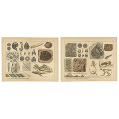
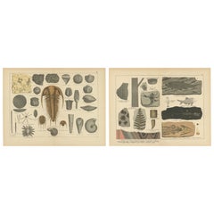
This pair of original lithographs originates from Schubert’s Naturgeschichte, a richly illustrated 19th-century natural history compendium. The plates focus on geology and the internal structure of the Earth, combining scientific accuracy with clear visual presentation.
Plate I presents a large schematic cross-section of the Earth’s crust, showing eruptive, metamorphic, and sedimentary formations in vivid color. The diagram illustrates granite, gneiss, porphyry, basalt, trachyte, and tuff, as well as sandstone, limestone, and marl layers. To the left, a vertical scale displays the relative thickness of strata down to 20,000 units, demonstrating geological depth in a way that was revolutionary for educational works of the 19th century. This plate captures the ambition of the time to represent the Earth’s internal structure comprehensively.
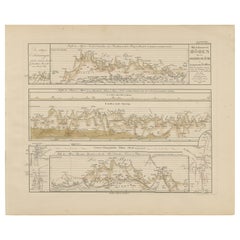
Plate II provides a series of geological cross-sections from well-known European mountain ranges and regions. These include the Harz Mountains, Thuringian Forest, Erzgebirge (Ore Mountains), Riesengebirge (Giant Mountains), Schwarzwald (Black Forest), the Schafstal Valley in South Tyrol, a profile of Mount Vesuvius from north to south, and strata of Upper Egypt with the Nile valley. Each section is carefully labeled with its constituent rock types, from granite intrusions to schists, sandstones, and limestones, making the plate both visually striking and scientifically instructive.
Antique Geological Cross-Sections – Structure of the Earth
European Mountains, c.1880
Together, these plates reflect the 19th-century fascination with geology, offering both students and collectors a window into the evolving science of Earth’s structure. They stand as decorative yet informative works that bridge natural science and art.
Condition report:
Both plates are in very good condition, with bright and well-preserved colors. Light age toning and scattered foxing in the margins, consistent with age, but no major defects. Plate marks visible.
Framing tips:
Displayed as a pair, these geological plates benefit from simple dark wood or black frames with ivory mats to highlight the vivid coloration of the strata. For added depth, a double mat with a stone-grey outer border emphasizes the scientific precision of the diagrams. These prints make a bold statement in a study, office, or educational setting.
Technique: Lithograph (partially hand-colored)
Maker: Schubert, Germany, c.1880
- Dimensions:Height: 12.72 in (32.3 cm)Width: 16.62 in (42.2 cm)Depth: 0.01 in (0.2 mm)
- Sold As:Set of 2
- Materials and Techniques:
- Place of Origin:
- Period:
- Date of Manufacture:circa 1880
- Condition:Both plates are in very good condition, with bright and well-preserved colors. Light age toning and scattered foxing in the margins, consistent with age, but no major defects. Plate marks visible.
- Seller Location:Langweer, NL
- Reference Number:Seller: BG-12801-1 BG-12801-1-21stDibs: LU3054346576322
About the Seller
5.0
Recognized Seller
These prestigious sellers are industry leaders and represent the highest echelon for item quality and design.
Platinum Seller
Premium sellers with a 4.7+ rating and 24-hour response times
Established in 2009
1stDibs seller since 2017
2,809 sales on 1stDibs
Typical response time: 1 hour
- ShippingRetrieving quote...Shipping from: Langweer, Netherlands
- Return Policy
More From This Seller
View AllAntique Geological Map of the World by Johnston
1850
Located in Langweer, NL
Antique map titled 'The Geological Structure of the Globe'. Original antique geological map of the world. This map originates from 'The Physica...
Category
Antique Mid-19th Century Maps
Materials
Paper

$286 Sale Price
20% Off
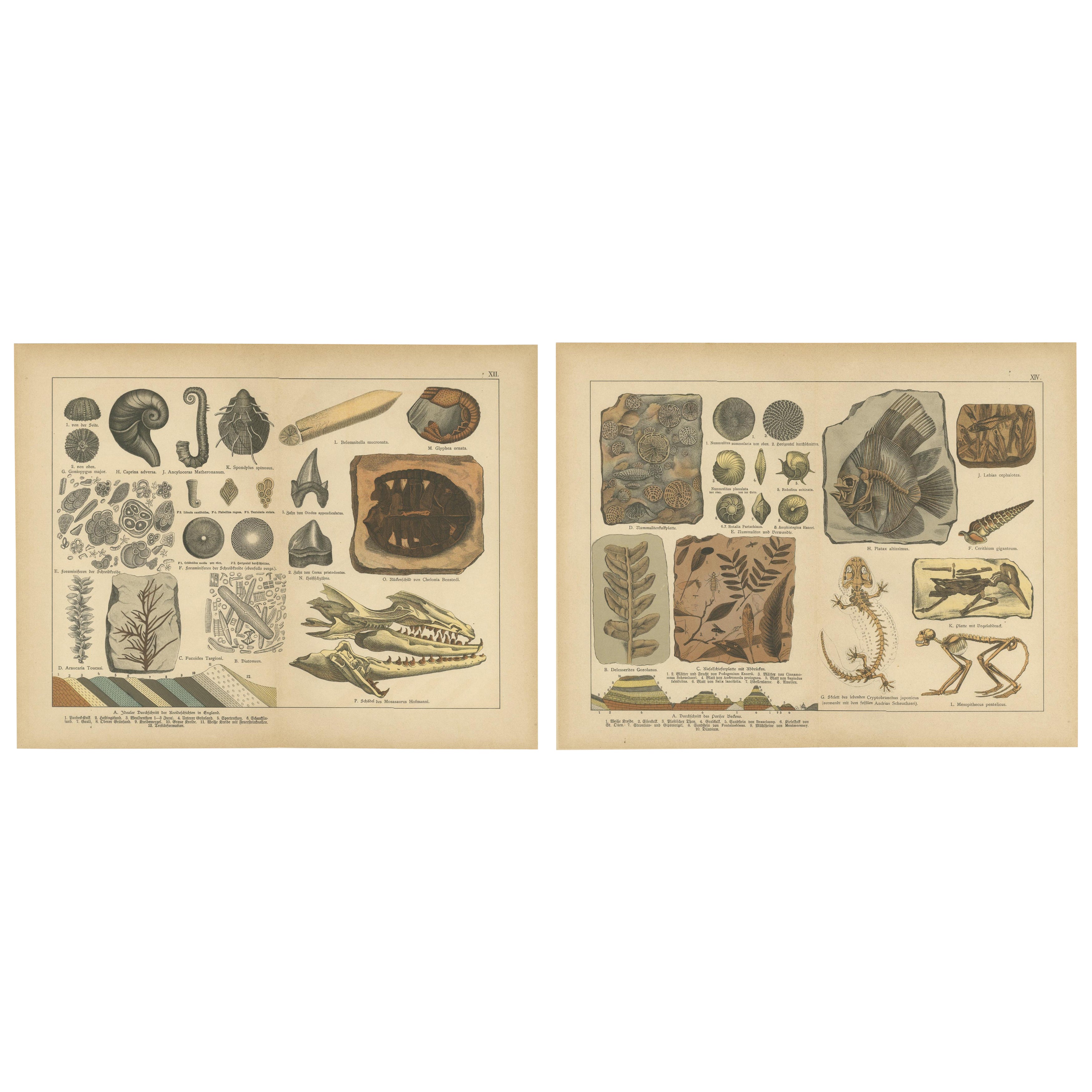
Antique Fossil Chromolithographs – Marine Life, Plants
Vertebrates, c.1880
Located in Langweer, NL
Antique Fossil Chromolithographs – Marine Life, Plants & Vertebrates, c.1880
This pair of antique chromolithographs presents a detailed visual survey ...
Category
Antique Late 19th Century German Maps
Materials
Paper
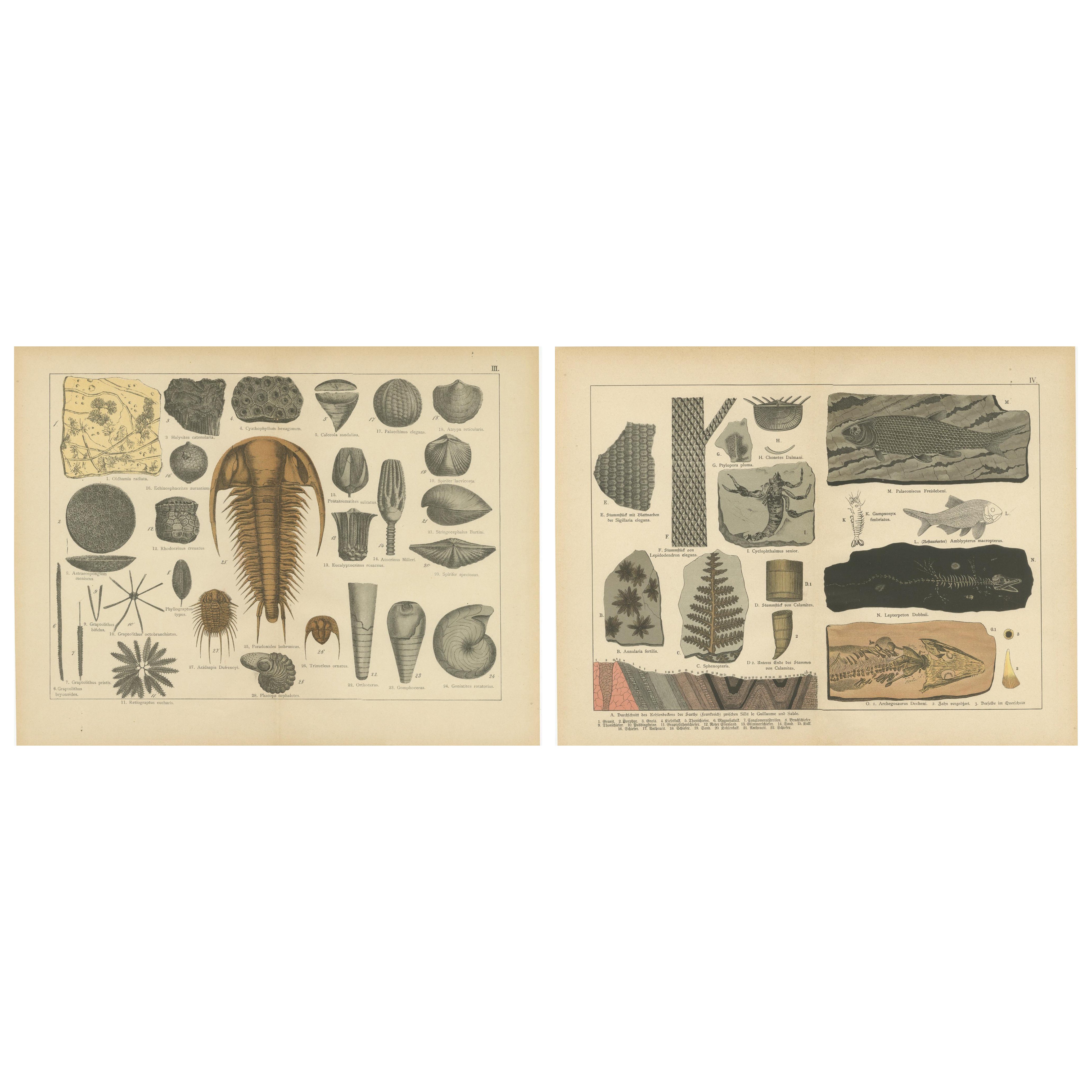
Decorative Antique Fossil Prints – Trilobites, Crinoids
Coal Measures, 1880
Located in Langweer, NL
Antique Fossil Prints – Trilobites, Crinoids, Fossil Fish & Coal Measures, c.1880
This pair of original lithographs originates from Schubert’s Naturge...
Category
Antique Late 19th Century German Maps
Materials
Paper
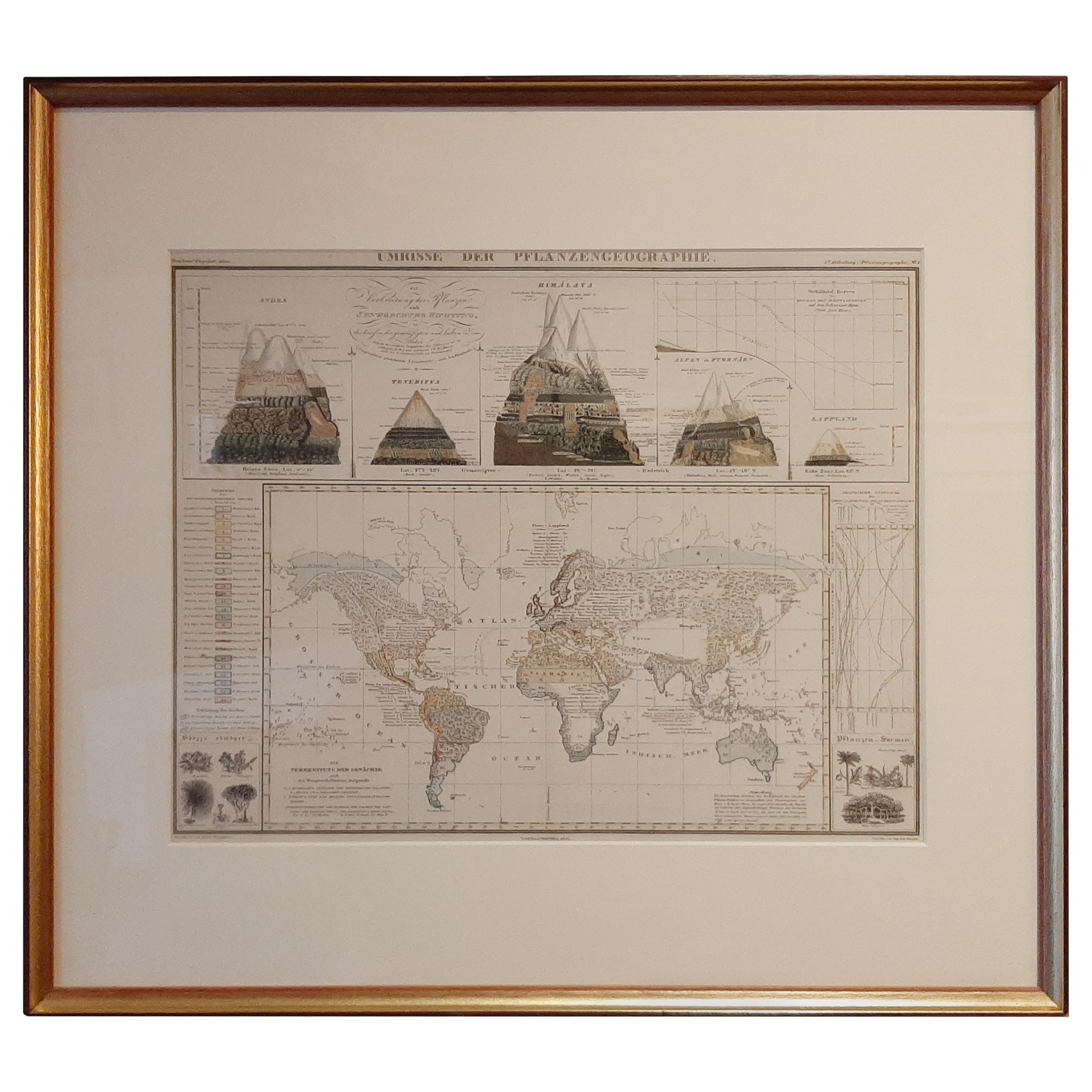
Antique Map of the Distribution of Vegetation throughout the World
1851
Located in Langweer, NL
Antique map titled 'Umrisse der Pflanzengeographie'. Original antique map showing the distribution of vegetation throughout the world. Five drawings above the map show the vegetation...
Category
Antique Mid-19th Century Maps
Materials
Paper
$716 Sale Price
20% Off
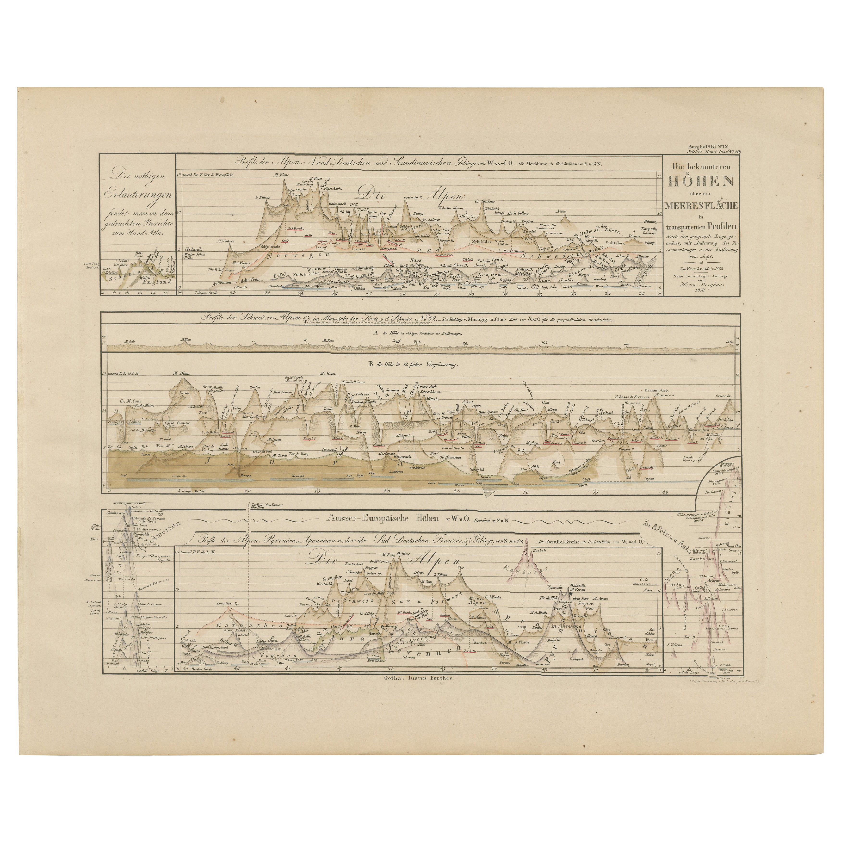
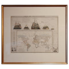
Mountain Elevation Profiles – Alps, Pyrenees, Andes
World Heights 1857
Located in Langweer, NL
Mountain Elevation Profiles – Alps, Pyrenees, Andes & World Heights 1857
This intriguing antique print shows comparative elevation profiles titled “Die bekannteren Höhen über der Me...
Category
Antique Mid-19th Century German Maps
Materials
Paper
Cartography Print 1852 – Educational Diagram of Mountains, Winds, and Reefs
Located in Langweer, NL
Cartographic Masterpiece 1852 – Illustrated Guide to Map Symbols and Climate
Description:
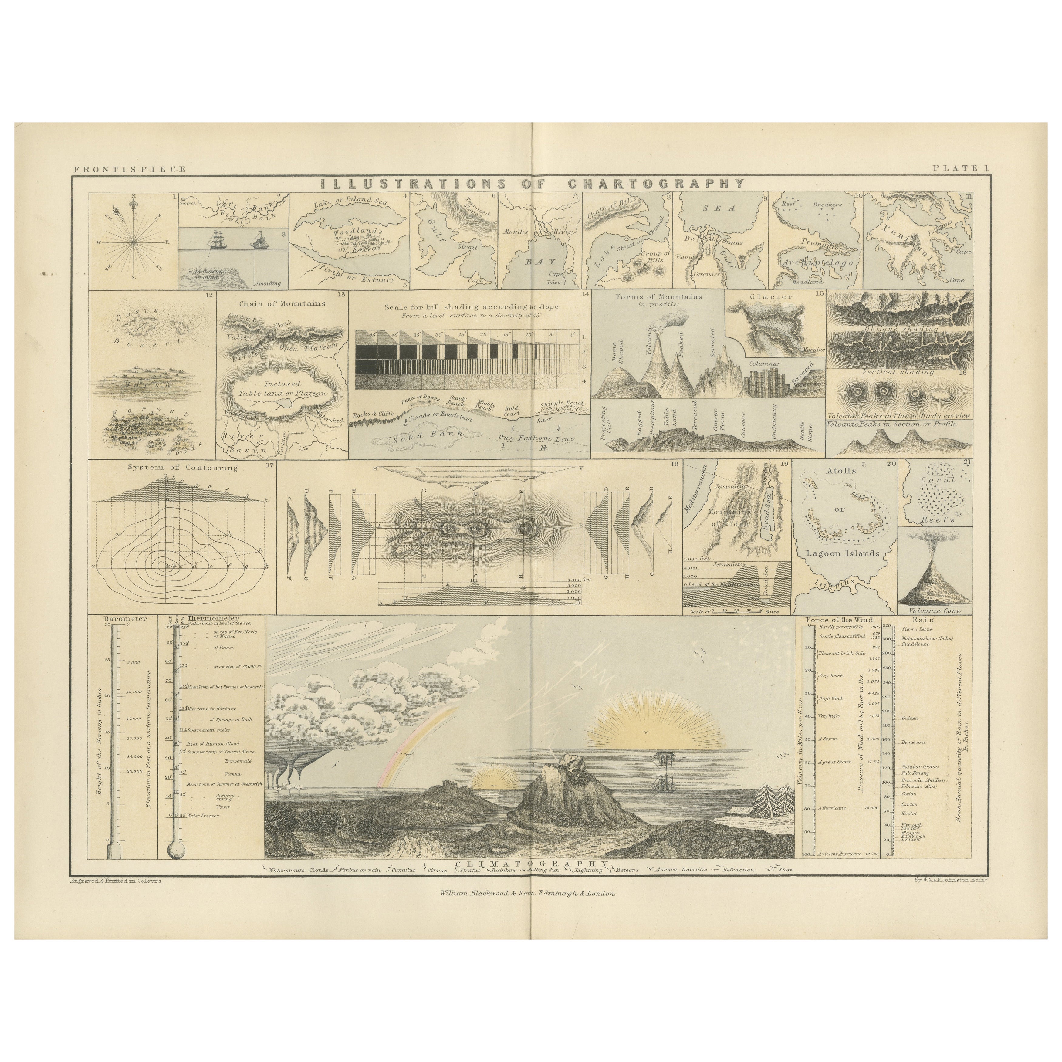
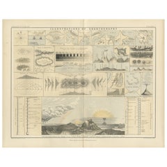
This original 1852 plate titled "Illustrations of Chartography Plate I" offers a fascinating and visually rich introduction to 19th-century mapping techniques. Published in A School Atlas of Physical Geography by the eminent Scottish cartographer Alexander Keith Johnston, the plate served as an educational tool designed to teach the principles of cartography, climatology, geology, and meteorology.
The detailed engravings include symbolic representations used on maps, such as forms of mountains, volcanoes, reef systems, and rainfall diagrams, along with charts of wind directions, cloud formations, and the system of contouring. Particularly notable is the lower section titled "Climatography," which combines scientific elements into a picturesque landscape featuring a rainbow, tornado, sea spray, and a mountain chain—all stylized to represent the natural forces shaping Earth’s surface.
Johnston was a leading cartographer of the Victorian period, and this atlas was used widely in schools and scientific circles for its clarity and innovative visual methods. The plate was engraved and printed by W. & A.K. Johnston, his family firm, which gained a global reputation for excellence in educational publishing.
This chart is not only historically significant but also aesthetically appealing, making it an ideal piece for collectors of antique scientific prints...
Category
Antique Mid-19th Century Prints
Materials
Paper
You May Also Like
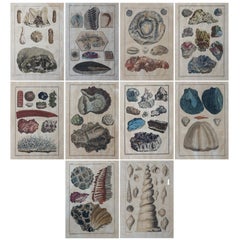
18th Century Set of Ten Hand-Colored Illustrations of Minerals by Joseph Buchoz
By Pierre Joseph Buchoz
Located in Haarlem, NL
Complete set of ten paper hand-colored illustrations from Premiere Centurie de Planches Enluminees et Non Enluminees (Decade 6 Regne Mineral) by Pierre Joseph Buchoz, Paris and Amste...
Category
Antique 18th Century French Prints
Materials
Paper
$2,320 Sale Price / set
20% Off
Free Shipping
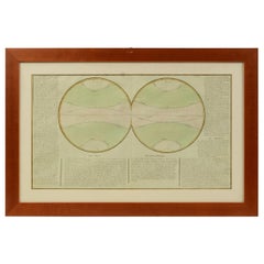
1850 Old French Map Depicting the Entire Earth
s Surface Divided into Two Parts
Located in Milan, IT
Map depicting the entire earth's surface divided into two parts corresponding to the two hemispheres and showing the Arctic to Antarctic polar circle, the tropics of Cancer and Capri...
Category
Antique Mid-19th Century French Maps
Materials
Glass, Wood, Paper
Old Map Depicting the Entire Earth
s Surface Divided into Six Parts France 1850
Located in Milan, IT
Map depicting the entire earth's surface divided into six parts which depicts the position of peoples on Earth based on the assumption that it is impossible for each people to have t...
Category
Antique Mid-19th Century French Maps
Materials
Glass, Wood, Paper

1850 Old French Map Depicting the Entire Earth
s Surface Divided into Two Parts
Located in Milan, IT
Geographical map depicting the entire earth's surface divided into two parts that correspond to the two hemispheres divided into small climatic zones that depict the climatic trend f...
Category
Antique Mid-19th Century French Scientific Instruments
Materials
Glass, Wood, Paper
1850 Old French Map Depicting the Entire Earth
s Surface Divided into Two Parts
Located in Milan, IT
Geographical map depicting the entire earth’s surface divided into two parts that correspond to the two hemispheres or globes, the map deals with the latitudes and longitudes, the me...
Category
Antique Mid-19th Century French Maps
Materials
Glass, Wood, Paper

Fine Antique 1856 Hand Watercolour Map of Dept Des Hautes Alpes by Levasseur
s
Located in West Sussex, Pulborough
We are delighted to offer for sale this stunning 1856 hand watercolour map of the Austrian Alps titled Dept Des Hautes Alpes taken from the Atlas National...
Category
Antique 1850s French Early Victorian Maps
Materials
Paper
