Items Similar to Decorative Hand-Coloured Antique Map of the Four Irish Provinces, Ireland, c1718


Want more images or videos?
Request additional images or videos from the seller
1 of 5
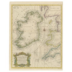
Decorative Hand-Coloured Antique Map of the Four Irish Provinces, Ireland, c1718
$1,017.23
£761.50
€850
CA$1,400.34
A$1,530.84
CHF 809.89
MX$18,319.02
NOK 10,304.63
SEK 9,432.85
DKK 6,475.95
About the Item
Title: Regni Hiberniae Accurata Tabula per Hermanum Moll
Decorative map of the four Irish provinces, Ireland, 1718, by Christoph Weigel (with credit to Herman Moll), engraved by Michael Kauffer. Old colouring.
Johann Christoph Weigel, known as Christoph Weigel the Elder (9 November 1654 – 5 February 1725), was a German engraver, art dealer and publisher. He was born at Redwitz, Free imperial city of Eger in Egerland, and died in Nuremberg, aged 70.
Condition: Good. Decorative colouring on handmade paper. One tiny pinhole on the lower Irish coast, hardly visible and one in the top border of the plate mark, outside the image. Overall al very attractive map of Ireland. Study image carefully.
- Dimensions:Height: 20.08 in (51 cm)Width: 15.75 in (40 cm)Depth: 0 in (0.02 mm)
- Materials and Techniques:
- Period:1710-1719
- Date of Manufacture:circa 1718
- Condition:Condition: Good. Decorative colouring on handmade paper. One tiny pinhole on the lower Irish coast, hardly visible and one in the top border of the plate mark, outside the image. Overall al very attractive map of Ireland. Study image carefully.
- Seller Location:Langweer, NL
- Reference Number:Seller: BG-13197-21stDibs: LU3054326492522
About the Seller
5.0
Recognized Seller
These prestigious sellers are industry leaders and represent the highest echelon for item quality and design.
Platinum Seller
Premium sellers with a 4.7+ rating and 24-hour response times
Established in 2009
1stDibs seller since 2017
2,793 sales on 1stDibs
Typical response time: <1 hour
- ShippingRetrieving quote...Shipping from: Langweer, Netherlands
- Return Policy
More From This Seller
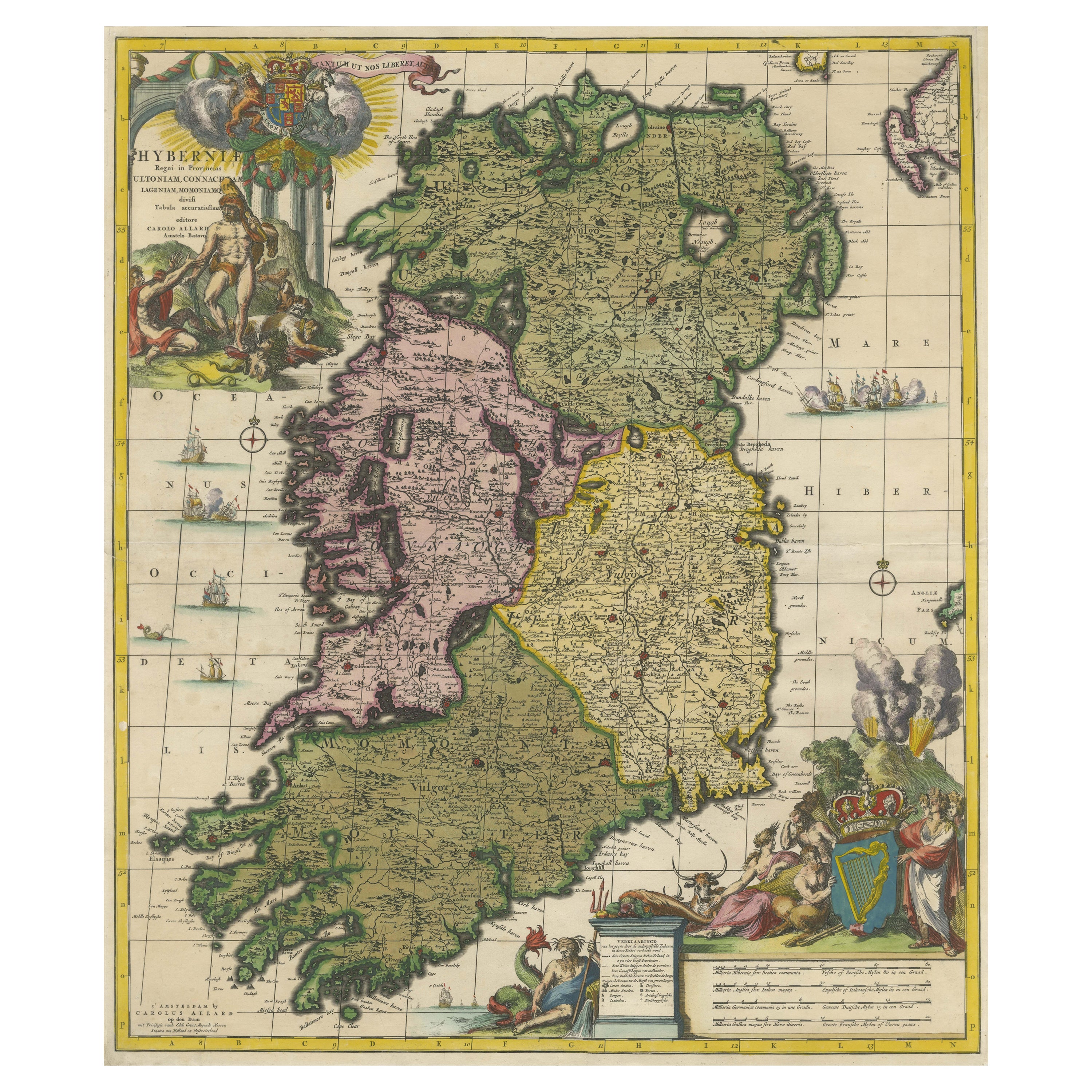
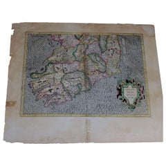
View AllHibernia Regnum Map by Carel Allard, 1700: Hand-Colored Provinces of Ireland
Located in Langweer, NL
This is a historical map of Ireland created by Carel Allard around 1700, titled "Hibernia Regnum in Quatuor Provincias Ultoniam, Connaciam, Lageniam, et Momoniam". The map is hand-colored and engraved. It includes two large decorative cartouches. The map is part of an atlas by Carel Allard, an Amsterdam-based cartographer.
Here are the detailed points about the map:
Maker: Carel Allard - a prominent Dutch cartographer and publisher from Amsterdam.
Atlas: Source Atlas - Likely part of an atlas published by Carel Allard, but specific title of the atlas isn't mentioned.
Interesting Features
1. Decorative Cartouches: The map features two large, ornate cartouches. One in the upper left depicts a classical figure and British Royal arms...
Category
Antique Early 1700s Maps
Materials
Paper

$2,010 Sale Price
30% Off
Map of Ireland: Early 19th Century - from the 1802 Tardieu Atlas
Located in Langweer, NL
Antique Map Description
**Title:** Carte d'Irlande
**Publication Details:**
- **Atlas Title:** Nouvel Atlas Universel de Géographie Ancienne et Moderne
- **Purpose:** For the Nouve...
Category
Antique Early 1800s Maps
Materials
Paper

$421 Sale Price
20% Off
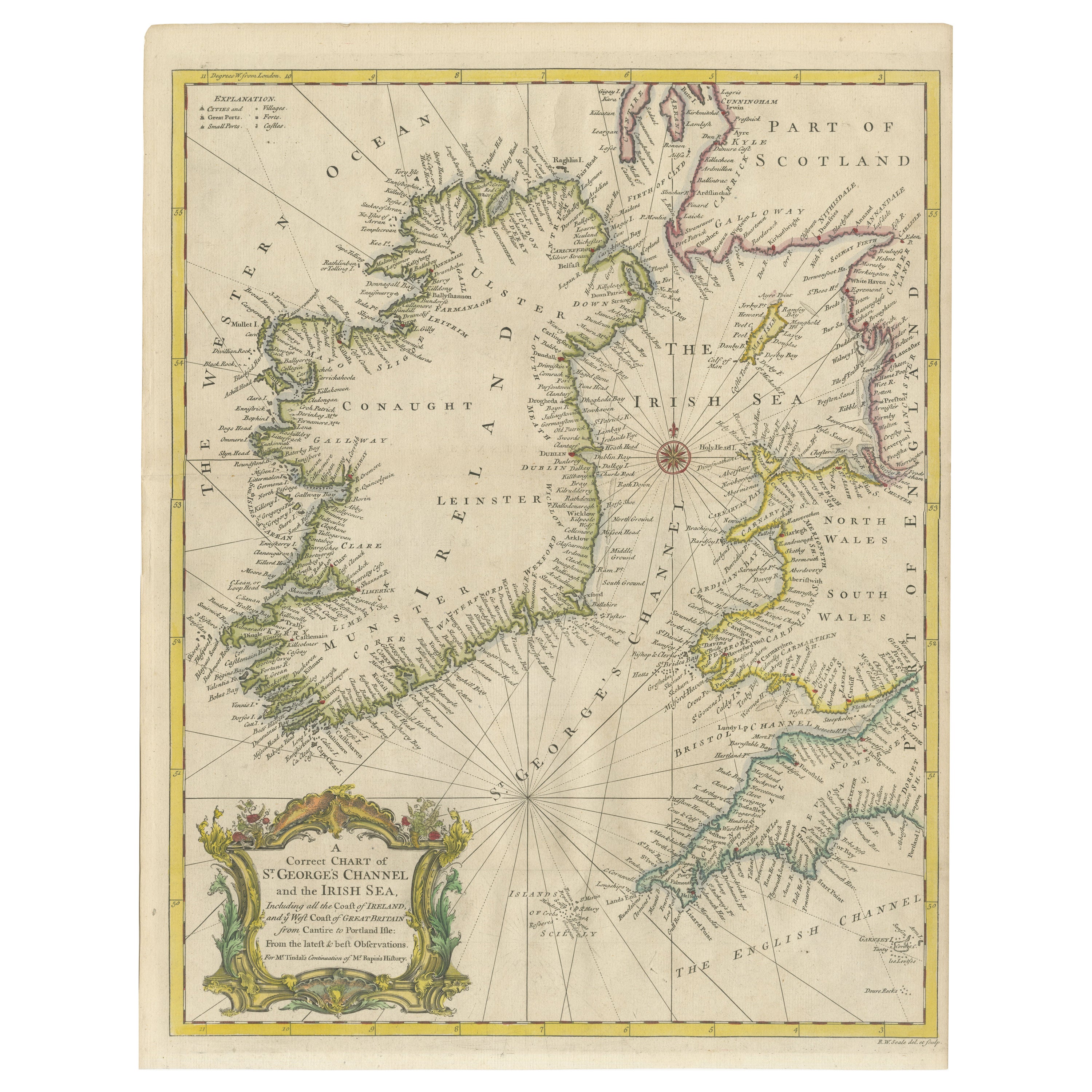
Hand-colored Nautical Chart: St. George
s Channel and the Irish Sea, 1744
Located in Langweer, NL
The map was engraved by Richard William Seale, a notable British engraver. This map is a fine example of 18th-century cartography, particularly focused on maritime navigation.
The m...
Category
Antique 1740s Maps
Materials
Paper
$631 Sale Price
20% Off
Antique Map of Ireland, 1903, with Intricate County Boundaries
Coastal Details
Located in Langweer, NL
Title: Antique Map of Ireland, 1903, with Intricate County Boundaries and Coastal Detail
Description:
This antique map of Ireland, engraved and published in 1903 by the esteemed W. ...
Category
Early 20th Century Maps
Materials
Paper

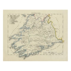
Antique 1830 Map of Munster, Ireland with Limerick, Cork, Kerry and Tipperary
Located in Langweer, NL
Title: Antique 1830 Map of Munster, Ireland with Limerick, Cork, Kerry, and Tipperary
Description: This 1830 German-language map, titled Britisches Reich – C. Kon: Ireland, focu...
Category
Antique 1830s Maps
Materials
Paper
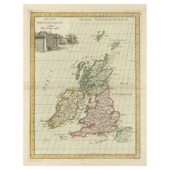
Antique Map of the British Isles with Contemporary Hand Coloring
Located in Langweer, NL
Antique map titled 'Les Isles Britanniques'. Original antique map of the British Isles, with original/contemporary hand coloring. Published by Crepe, circa 1767.
Category
Antique Late 18th Century Maps
Materials
Paper
$268 Sale Price
20% Off
You May Also Like
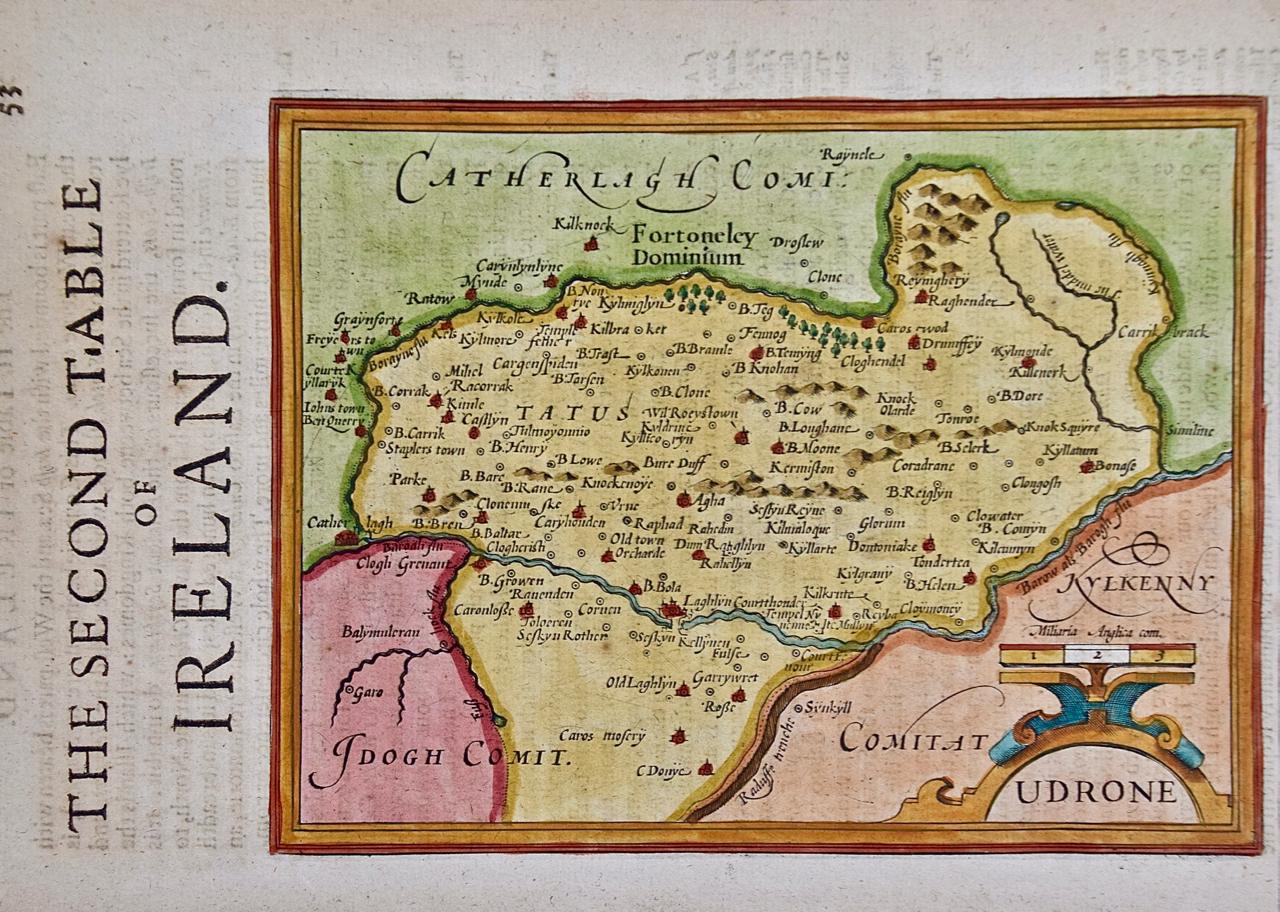
Southeastern Ireland: A 17th Century Hand Colored Map by Mercator and Hondius
By Gerard Mercator
Located in Alamo, CA
A 17th century copperplate hand-colored map entitled "The Second Table of Ireland, Udrone" by Gerard Mercator and Jodocus Hondius, published in Amsterdam in 1635 in 'Cosmographicall ...
Category
1630s Landscape Prints
Materials
Engraving

Large Original Antique Map of Ireland. C.1900
Located in St Annes, Lancashire
Fabulous map of Ireland
Original color.
Engraved and printed by the George F. Cram Company, Indianapolis.
Published, C.1900.
Unframed.
Free shipping.
Category
Antique 1890s American Maps
Materials
Paper

1585 Mercator Map of Ireland, Entitled "Irlandiae Regnvm, " Hand Colored Ric0006
Located in Norton, MA
1585 Mercator map of Ireland, entitled
"Irlandiae Regnvm."
Hand Colored
Description: Published in Amsterdam by Mercator/Hondius ca. 1585.
Artists and Engravers: 1585 Mercator map of Ireland, entitled "Irlandiae Regnvm." Copperplate engraving on verge type hand laid paper with watermark. Description: Published in Amsterdam by Mercator/Hondius ca. 1585.Artists and Engravers: Mercator was born in Rupelmonde in Flanders and studied in Louvain under Gemma Frisius, Dutch writer, astronomer and mathematician. The excellence of his work brought him the patronage of Charles V, but in spite of his favor with the Emperor he was caught up in the persecution of Lutheran protestants and charged with heresy, fortunately without serious consequences. No doubt the fear of further persecution influenced his move in 1552 to Duisburg, where he continued the production of maps, globes and instruments. Mercator's sons and grandsons, were all cartographers and made their contributions in various ways to his atlas. Rumold, in particular, was responsible for the complete edition in 1595. The map plates...
Category
Antique 16th Century Dutch Maps
Materials
Paper
Original Antique Map of Ireland- Kerry. C.1840
Located in St Annes, Lancashire
Great map of Kerry
Steel engraving
Drawn under the direction of A.Adlard
Published by How and Parsons, C.1840
Unframed.
Category
Antique 1840s English Maps
Materials
Paper

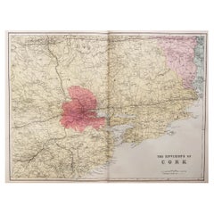
Large Original Antique Map of the Environs of Cork, Ireland, circa 1880
Located in St Annes, Lancashire
Great map of The Environs of Cork
Published circa 1880
Unframed
Free shipping.
Category
Antique 1880s Scottish Maps
Materials
Paper
Original Antique Map of Ireland- Tipperary and Waterford. C.1840
Located in St Annes, Lancashire
Great map of Tipperary and Waterford
Steel engraving
Drawn under the direction of A.Adlard
Published by How and Parsons, C.1840
Unframed.
Category
Antique 1840s English Maps
Materials
Paper

More Ways To Browse
Map Of Middle East
17th Century American Furniture
Afghanistan Map
Antique Celestial Maps
Antique Maps Virginia
Hand Drawn Map
Map Of Israel
Map Of Poland
Sicily Map
Used Durham Furniture
Antique Maps Of Israel
Antique Maps Of Russian Empire
J C Walker Map
Massachusetts Antiques
Persian Maps
Afghanistan Antique Map
Antique Furniture Delaware
Antique Furniture Wisconsin