Items Similar to Decorative Map of the Holy Land, Wanderings of Moses by Pieter Mortier, ca. 1700


Want more images or videos?
Request additional images or videos from the seller
1 of 10
Decorative Map of the Holy Land, Wanderings of Moses by Pieter Mortier, ca. 1700
$405.14
£301.77
€340
CA$557.91
A$607.27
CHF 321.77
MX$7,303.40
NOK 4,091.26
SEK 3,749.19
DKK 2,590.57
About the Item
Decorative Map of the Holy Land, Wanderings of Moses by Pieter Mortier, ca. 1700
Antique decorative map of the Holy Land depicting the Exodus of Moses and the Children of Israel from Egypt to the Promised Land. Engraved and published in Amsterdam by Pieter Mortier (1661–1711), circa 1700.
The map traces the Israelites’ journey from Rameses, across the Red Sea, and through the wilderness towards Canaan. Notable biblical episodes are shown, including the miraculous crossing of the Red Sea, with Pharaoh’s army swallowed by the waters, the arrival at Mount Sinai in the eighth year, and the scene of idolatry worship. The wandering continues across the wilderness, with encampments marking each year, until year 33 at Kadesh, and finally to the Jordan River in year 43, near the Promised Land.
The engraving is richly illustrated with biblical vignettes: Moses at Sinai, encampments of the Israelites, and dramatic scenes of deliverance and worship. The large decorative cartouche in the upper right features figures in classical dress, reinforcing the biblical theme, and is characteristic of Mortier’s baroque cartographic style. The Mediterranean coastline, Egypt, and the Dead Sea are clearly depicted, blending geography with sacred narrative.
This map was published in Histoire du Vieux et du Nouveau Testament, one of the grand illustrated biblical histories of the early 18th century. Pieter Mortier, an influential Amsterdam publisher, held a privilege from 1690 to distribute French works in the Netherlands. His editions are prized for their fine copper engravings, combining scholarly content with elaborate decoration.
This map stands as both a work of art and a devotional piece, appealing to collectors of early biblical cartography, Dutch engraving, and sacred history.
Condition report:
Good condition. Original central fold as issued. Light toning and faint margin wear, with small handling marks consistent with age. Strong dark impression with excellent detail. Please review the images carefully.
Framing tips:
An ivory or parchment-style mount will complement the biblical theme, while a dark walnut or ebonized frame enhances the engraving’s contrast. A gilt frame with inner line would highlight the baroque cartouche and give a museum-quality presentation.
Technique: Copperplate engraving
Maker: Pieter Mortier, Amsterdam, ca. 1700
- Dimensions:Height: 17.72 in (45 cm)Width: 20.48 in (52 cm)Depth: 0.01 in (0.2 mm)
- Materials and Techniques:Paper,Engraved
- Place of Origin:
- Period:1700-1709
- Date of Manufacture:circa 1700
- Condition:Good condition. Original central fold as issued. Light toning and faint margin wear, with small handling marks consistent with age. Strong dark impression with excellent detail. Please review the images carefully.
- Seller Location:Langweer, NL
- Reference Number:Seller: BG-12063-31stDibs: LU3054346663752
About the Seller
5.0
Recognized Seller
These prestigious sellers are industry leaders and represent the highest echelon for item quality and design.
Platinum Seller
Premium sellers with a 4.7+ rating and 24-hour response times
Established in 2009
1stDibs seller since 2017
2,824 sales on 1stDibs
Typical response time: 1 hour
- ShippingRetrieving quote...Shipping from: Langweer, Netherlands
- Return Policy
More From This Seller
View AllAntique Map of the Holy Land by Van Luchtenburg, c.1720
Located in Langweer, NL
Antique map titled 'Heylige Land verdeeld in de Twaalf Stammen Israels (..).' Highly detailed map of the Holy Land divided into 12 tribes of Israel...
Category
Antique 18th Century Maps
Materials
Paper

Antique Map of the Holy Land by Keur, 1748
Located in Langweer, NL
Antique Map Holy Land titled 'De Gelegentheyd van t'Paradys ende t'Landt Canaan, Mitsgaders d'eerst bewoonde Landen der Patriarchen'. Includes five decorative vignettes, including No...
Category
Antique 18th Century Maps
Materials
Paper

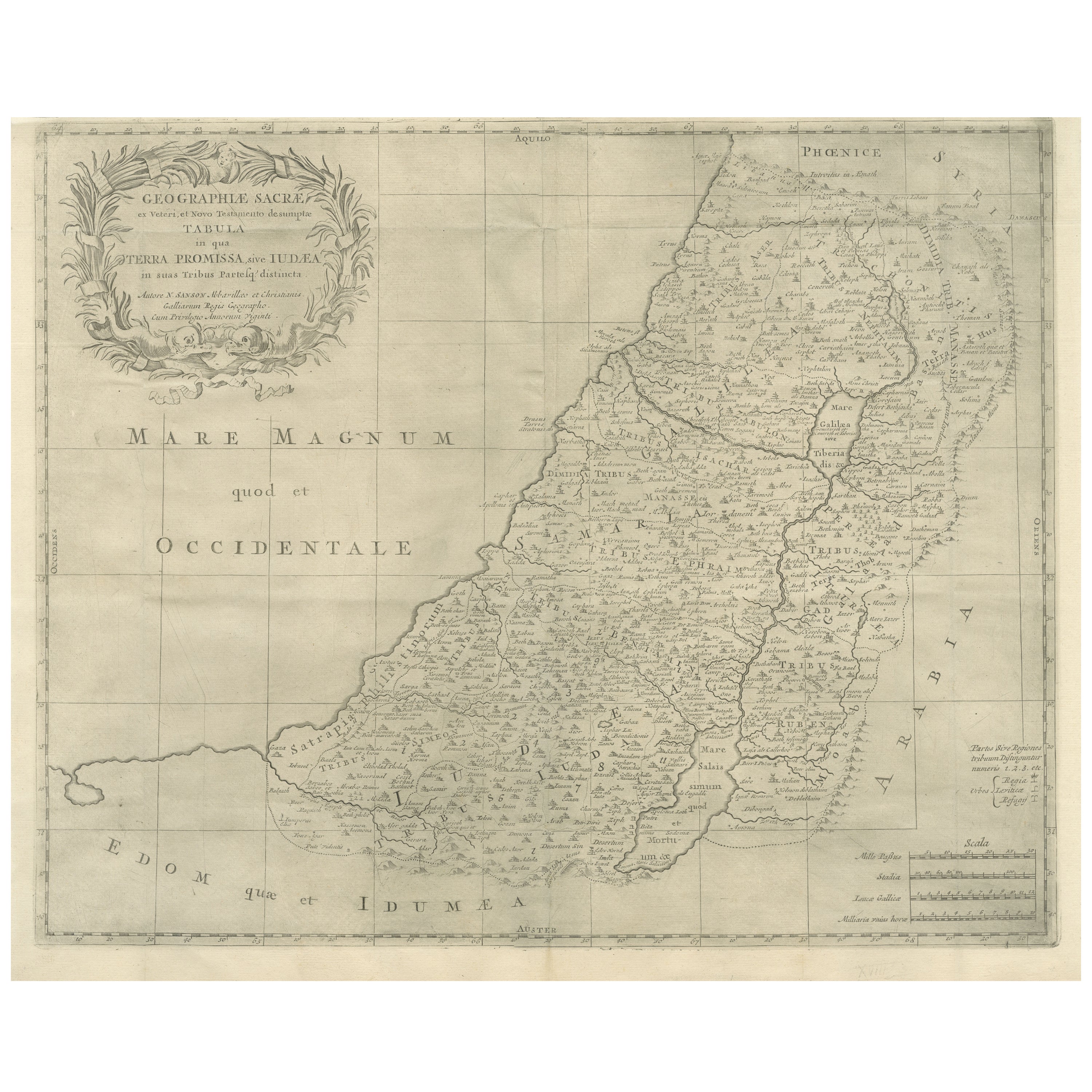
Holy Land Map, Terra Promissa or Judaea – Nicolas Sanson, c.1700
Located in Langweer, NL
Holy Land Map, Terra Promissa or Judaea – Nicolas Sanson, c.1700
This antique map depicts the Holy Land, or Terra Promissa (Promised Land), as described in the Old and New Testament...
Category
Antique Early 18th Century German Maps
Materials
Paper
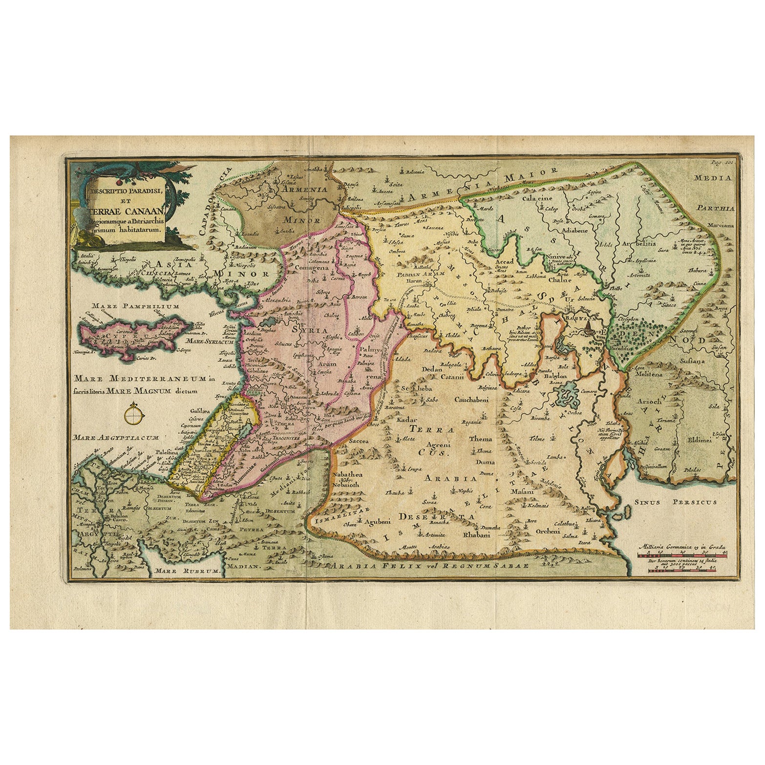
Antique Map of the Holy Land and Paradise – Terrae Canaan Map, c.1720
Located in Langweer, NL
Antique Map of the Holy Land and Paradise by François Halma, c.1720
Beautiful early 18th-century hand-colored map of the Middle East extending from the Mediterranean Sea to the Pers...
Category
Antique Early 18th Century Dutch Maps
Materials
Paper

Antique Holy Land Map, Twelve Tribes of Israel – Covens
Mortier, c.1700
Located in Langweer, NL
Antique Holy Land Map, Twelve Tribes of Israel – Covens
Mortier, c.1700
Description:
This finely engraved early 18th-century map depicts the Holy Land divided according to the...
Category
Antique Early 18th Century French Maps
Materials
Paper

Antique Map of the Holy Land by Danckerts, c.1710
Located in Langweer, NL
Antique map titled 'Afbeeldinge van de Veertich-Iaarige Reyse der Kinderen Israëls uyt Egypten door de Roode Zee en de Woestyne tot in 't Beloofde Landt Canaan'. Map of the Holy Land...
Category
Antique 18th Century Maps
Materials
Paper

You May Also Like
17th Century Dutch Map of the Holy Land at the Time of Jesus by Visscher
By Nicolaus Visscher
Located in Alamo, CA
This detailed Dutch map entitled "Het Beloofe de Landt Canaan door wandelt van onsen Salichmaecker Iesu Christo, nessens syne Apostelen" by Nicolaes Visscher (1610-1679), published i...
Category
1660s Prints and Multiples
Materials
Engraving

Map of Scotland - Etching by Johannes Blaeu - 1650s
Located in Roma, IT
Map of Scotland is an geographic map realized by Johannes Blaeu.
Etching, printed in 1660 ca.
Copper engraving, colored (coeval coloring), on paper, with center fold;
Latin text. ...
Category
1650s Modern Figurative Prints
Materials
Etching
$446 Sale Price
20% Off
Southerlandia Map - Etching by Johannes Janssonius - 1650
By Johannes Janssonius
Located in Roma, IT
Southerlandia Map is an ancient map realized in 1650 by Johannes Janssonius (1588-1664).
The Map is Hand-colored etching, with coeval watercoloring.
Good conditions.
From Atlantis...
Category
1650s Modern Figurative Prints
Materials
Etching

Antique Map - Mar Di Athiopia - Etching by Johannes Janssonius - 1650s
By Johannes Janssonius
Located in Roma, IT
Antique Map - Mar Di Athiopia is an antique map realized in 1650 by Johannes Janssonius (1588-1664).
The Map is Hand-colored etching, with coeval watercolorang.
Good conditions wit...
Category
1650s Modern Figurative Prints
Materials
Etching

Map Holy Land La Terre Sainte Engraved van Loon Published N de Fer 1703 French
Located in BUNGAY, SUFFOLK
La Terre Sainte, The Holy Land, Tiree Des Memoires De M.De.La Rue. Par N. de Fer. Geographe de Sa Majeste Catoliq et de Monseigneur le Dauphin. Avec Privil du Roi 1703
Detailed map of the Holy Land from Nicholas de Fer's L'Atlas Curieux ou le Monde. East is oriented at the top.
MAKER Nicolas de Fer 1646-1720
The French cartographer and engraver, Nicolas de Fer, was a master at creating maps that were works of art. The maps that he published were printed during the Baroque period when the decorative arts were characterized by ornate detail. De Fer’s detailed maps and atlases were valued more for their decorative content than their geographical accuracy.
Nicolas de Fer was born in 1646. His father, Antoine de Fer, owned a mapmaking firm. At the age of twelve, Nicolas was apprenticed to a Parisian engraver named Louis Spirinx. The family business was starting to decline when his father died in 1673. Nicolas de Fer’s mother, Genevieve, took over the business after the death of her husband. In 1687 the business was passed on to Nicolas and the profits increased after he took over the firm. Nicolas de Fer was a prolific cartographer who produced atlases and hundreds of single maps. He eventually became the official geographer to King Louis XIV of France and King Philip V...
Category
Antique Early 1700s French Louis XIV Maps
Materials
Paper

Map of Mar Del Nort - Etching by Johannes Janssonius - 1650s
By Johannes Janssonius
Located in Roma, IT
Antique Map -Mar Del Nort is an antique map realized in 1650 by Johannes Janssonius (1588-1664).
The Map is Hand-colored etching, with coeval watercolorang.
Good conditions with sl...
Category
1650s Modern Figurative Prints
Materials
Etching
