Items Similar to Denmark
Schleswig-Holstein Map with Copenhagen
Iceland Insets – 1865 Atlas

Video Loading
Want more images or videos?
Request additional images or videos from the seller
1 of 11
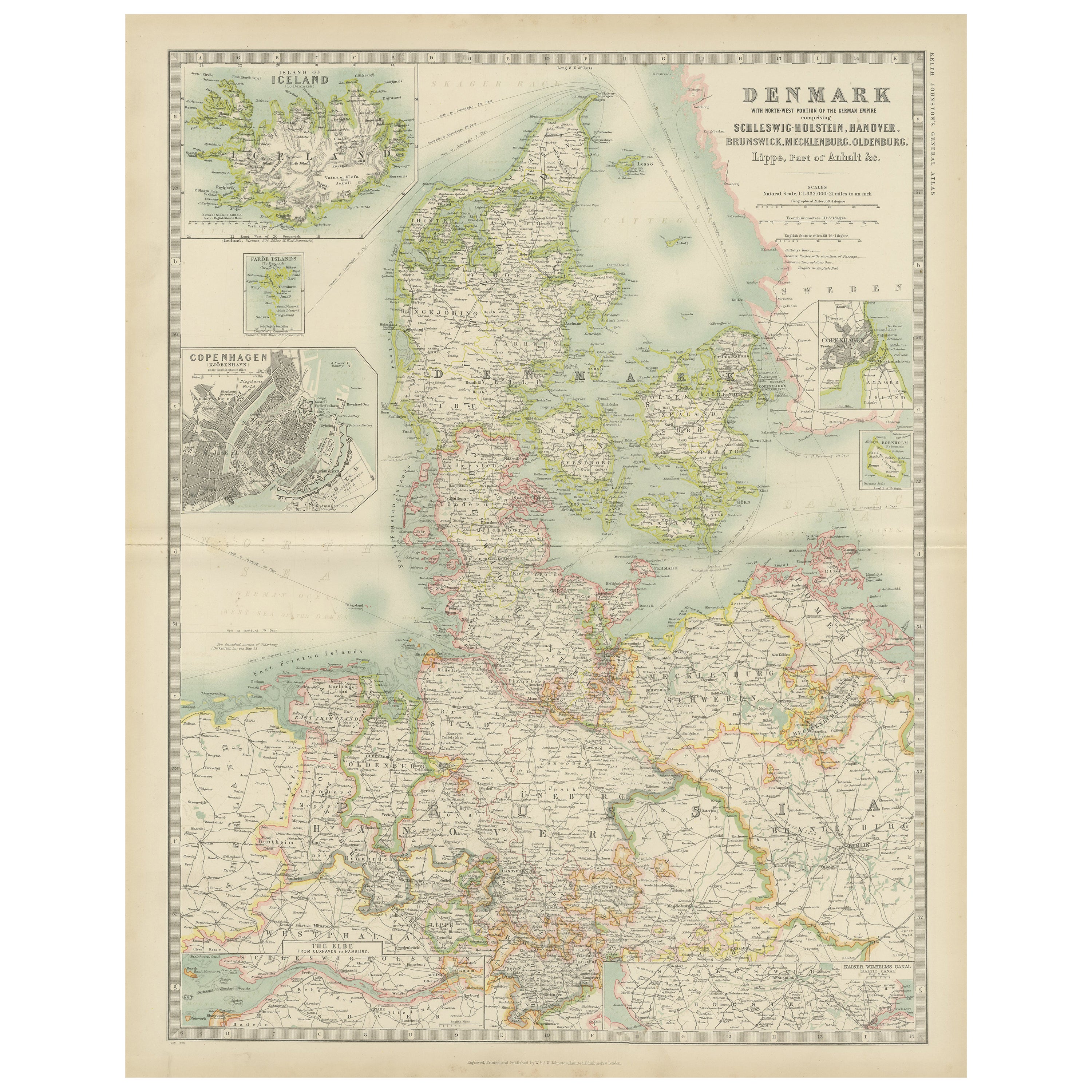
Denmark
Schleswig-Holstein Map with Copenhagen
Iceland Insets – 1865 Atlas
$329.41
£246.32
€275
CA$453.84
A$494.97
CHF 262.20
MX$5,934.04
NOK 3,339.31
SEK 3,053.55
DKK 2,095.61
About the Item
Denmark
Schleswig-Holstein Map with Copenhagen
Iceland Insets – 1865 Atlas
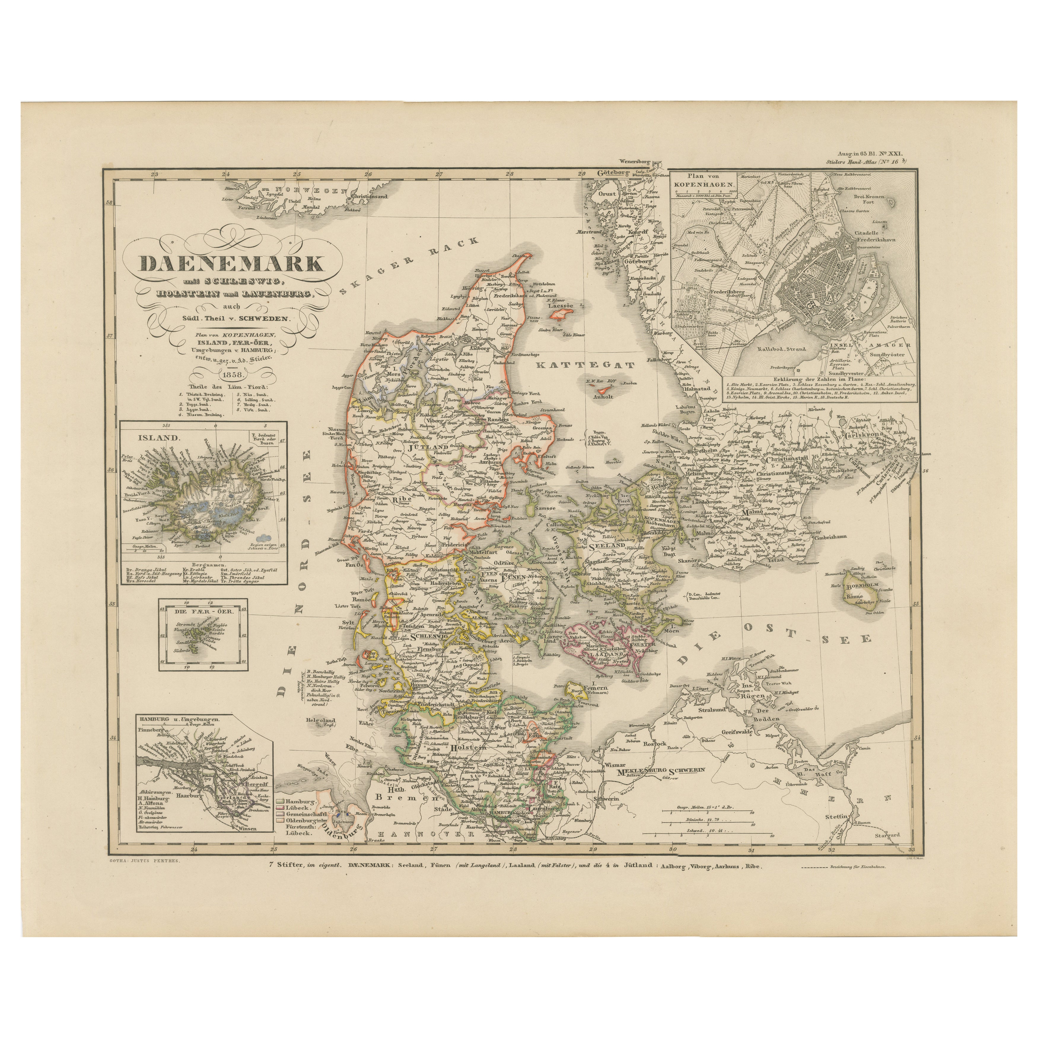
This detailed antique map titled Denmark and the Duchies Schleswig, Holstein
Lauenburg; Hanover, Brunswick, Mecklenburg, Oldenburg, Anhalt and Lippe presents a richly informative view of Northern Europe in the mid-19th century. Published in 1865 by William Blackwood and Sons as part of Alexander Keith Johnston’s Royal Atlas of Modern Geography, it reflects the high cartographic standards of the Victorian era.
The map spans Denmark and the surrounding German duchies and principalities, with political borders clearly outlined in color. It captures a significant historical period just before the final integration of Schleswig and Holstein into Prussia following the Second Schleswig War (1864). The map shows rivers, roads, railways, towns, cities, and administrative divisions in intricate detail, providing valuable insights into the geopolitical landscape of the time.
Inset maps add to the utility and interest of the sheet. These include a focused plan of Copenhagen, a wider view of Iceland, and a detailed rendering of the Elbe River near Hamburg. Johnston, one of the most respected British geographers of his time, produced this atlas for educational and professional use, with precise engraving and elegant presentation.
Collectors and historians will find this map valuable both for its geographic content and its aesthetic appeal. It illustrates a shifting European order during a period of rapid modernization, nationalism, and boundary redrawing, making it a compelling document of 19th-century cartographic history.
Condition report: Very good condition overall. Original outline color. Horizontal center fold as issued. Slight marginal toning and a few minor handling creases, but no tears, repairs, or major blemishes.
Framing tips: A wide off-white mount with a clean-lined walnut or ebonized wood frame would suit this map well. Consider using UV-protective glass to preserve the subtle color work and detail.
- Dimensions:Height: 24.41 in (62 cm)Width: 19.1 in (48.5 cm)Depth: 0.02 in (0.5 mm)
- Materials and Techniques:
- Period:
- Date of Manufacture:1865
- Condition:Very good condition overall. Original outline color. Horizontal center fold as issued. Slight marginal toning and a few minor handling creases, but no tears, repairs, or major blemishes.
- Seller Location:Langweer, NL
- Reference Number:Seller: BG-05553/171stDibs: LU3054310726803
About the Seller
5.0
Recognized Seller
These prestigious sellers are industry leaders and represent the highest echelon for item quality and design.
Platinum Seller
Premium sellers with a 4.7+ rating and 24-hour response times
Established in 2009
1stDibs seller since 2017
2,791 sales on 1stDibs
Typical response time: <1 hour
- ShippingRetrieving quote...Shipping from: Langweer, Netherlands
- Return Policy
More From This Seller
View AllAntique Map of Denmark by Johnston
1909
Located in Langweer, NL
Antique map titled 'Denmark'. Original antique map of Denmark. With inset maps of Iceland, Faroe Island, and Copenhagen. This map originates from the ‘Royal Atlas of Modern Geography...
Category
Early 20th Century Maps
Materials
Paper
$239 Sale Price
20% Off
Denmark
German Empire – Antique Map by A.K. Johnston, 1882 Atlas Edition
Located in Langweer, NL
Denmark & German Empire – Antique Map by A.K. Johnston, 1882 Atlas Edition
This detailed antique map titled Denmark with North-West portion of the German Empire comprising Schleswig...
Category
Antique 19th Century English Maps
Materials
Paper
$229 Sale Price
20% Off
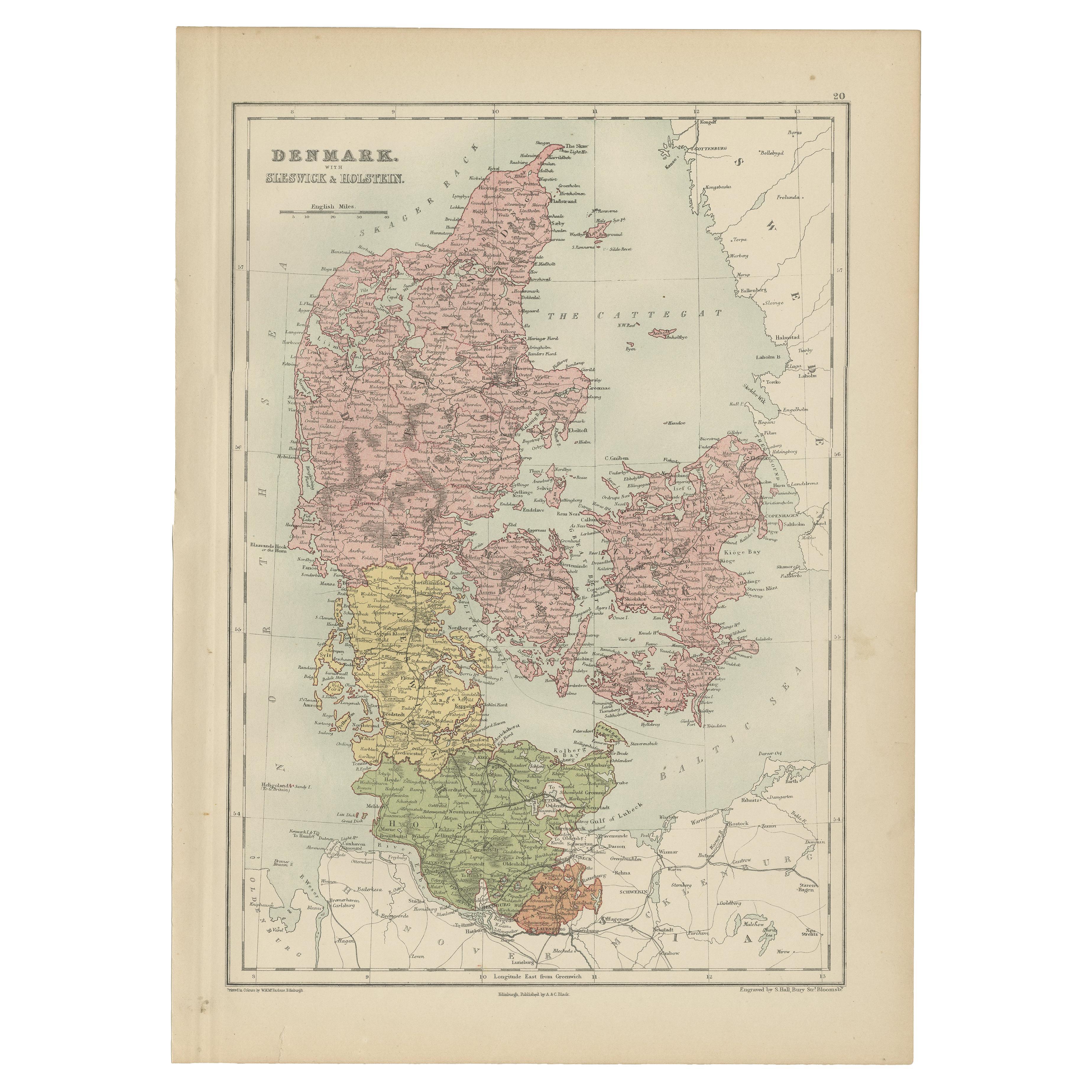
Antique Map of Denmark with Schleswig
Holstein by A
C. Black, 1870
Located in Langweer, NL
Antique map titled 'Denmark with Schleswig & Holstein'. Original antique map of Denmark with Schleswig & Holstein. This map originates from ‘Black's General Atlas of The World’. Publ...
Category
Antique Late 19th Century Maps
Materials
Paper

$125 Sale Price
40% Off
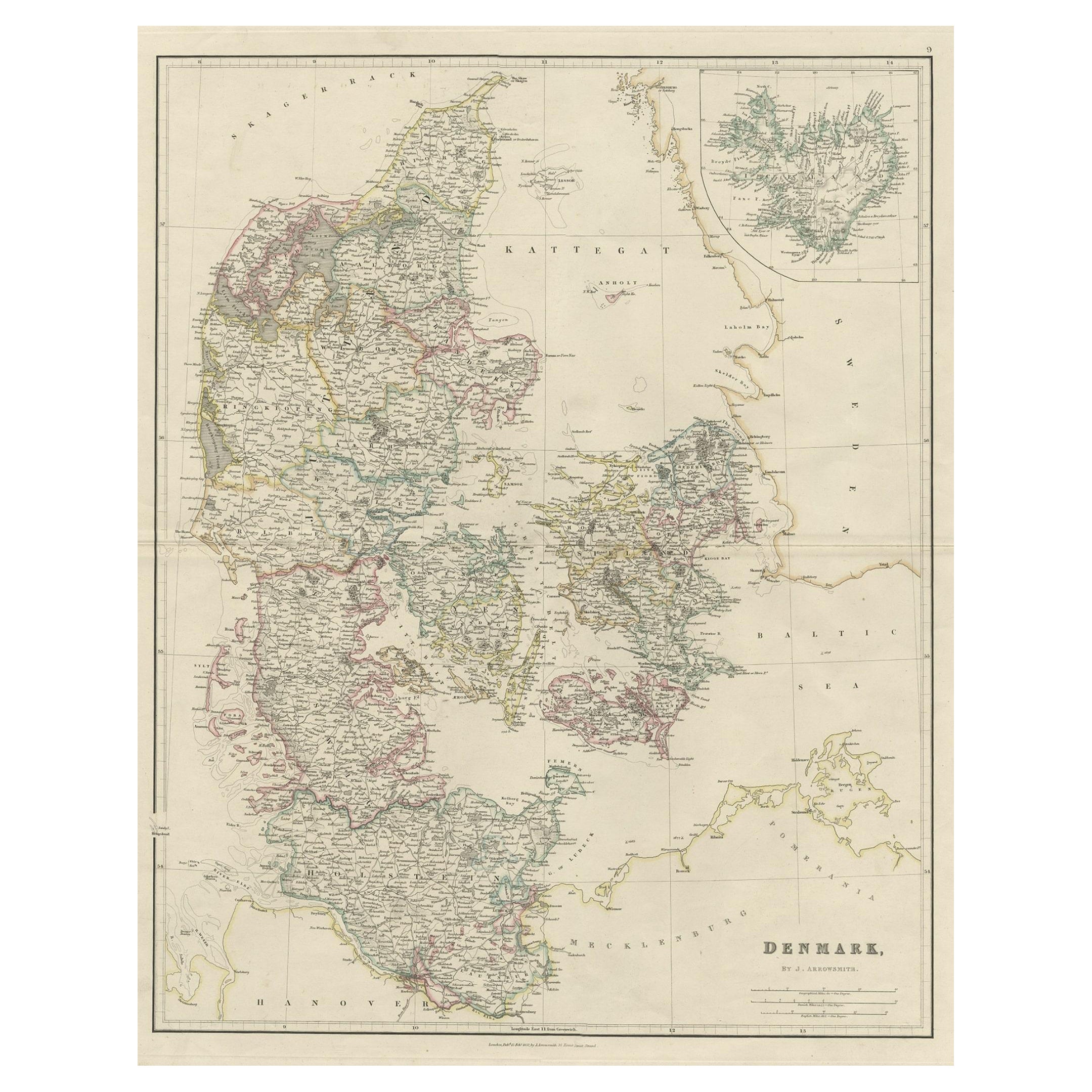
Antique Map of Denmark with an Inset Map of Iceland, 1832
Located in Langweer, NL
Antique map titled 'Denmark'. Large map of Denmark with an inset map of Iceland.
Artists and Engravers: Published by J. Arrowsmith in London, 1832.
Condition: Good, general age...
Category
Antique 19th Century Maps
Materials
Paper

Antique Map of Denmark by Lowry, 1852
Located in Langweer, NL
Antique map titled 'Denmark'. Original map of Denmark. This map originates from 'Lowry's Table Atlas constructed and engraved from the most recent Authorities' by J.W. Lowry. Publish...
Category
Antique Mid-19th Century Maps
Materials
Paper

$95 Sale Price
20% Off
Antique Map of Denmark 1858 – Includes Iceland
Copenhagen Plan
Located in Langweer, NL
Antique Map of Denmark 1858 – Includes Iceland & Copenhagen Plan
This finely detailed antique map of Denmark was published in 1858 by Justus Perthes in Gotha, as part of the renowne...
Category
Antique Mid-19th Century German Maps
Materials
Paper
You May Also Like
Denmark. Century Atlas antique vintage map
Located in Melbourne, Victoria
'The Century Atlas. Denmark'
Original antique map, 1903.
Inset maps of 'Faroe Islands', 'Iceland' and 'Copenhagen'.
Central fold as issued. Map name and number printed on the reve...
Category
Early 20th Century Victorian More Prints
Materials
Lithograph

Original Antique English County Map, Nottinghamshire, J
C Walker, 1851
Located in St Annes, Lancashire
Great map of Nottinghamshire
Original colour
By J & C Walker
Published by Longman, Rees, Orme, Brown & Co. 1851
Unframed.
Category
Antique 1850s English Other Maps
Materials
Paper

Original Antique English County Map, Herefordshire, J
C Walker, 1851
Located in St Annes, Lancashire
Great map of Herefordshire
Original colour
By J & C Walker
Published by Longman, Rees, Orme, Brown & Co. 1851
Unframed.
Category
Antique 1850s English Other Maps
Materials
Paper

1849 Map of "Europaische Russland",
Meyer Map of European Russia
, Ric. R017
Located in Norton, MA
1849 Map of
"Europaische Russland"
( Meyer Map of European Russia)
Ric.r017
A lovely map of European Russia dating to 1849 by Joseph Meyer. It covers the European portions of...
Category
Antique 19th Century Unknown Maps
Materials
Paper

1853 Map of "Russia in Europe Including Poland" Ric.r016
Located in Norton, MA
Description
Russia in Europe incl. Poland by J Wyld c.1853
Hand coloured steel engraving
Dimension: Paper: 25 cm W x 33 cm H ; Sight: 22 cm W x 28 cm H
Condition: Good ...
Category
Antique 19th Century Unknown Maps
Materials
Paper

Original Antique English County Map, Warwickshire, J
C Walker, 1851
Located in St Annes, Lancashire
Great map of Warwickshire
Original colour
By J & C Walker
Published by Longman, Rees, Orme, Brown & Co. 1851
Unframed.
Category
Antique 1850s English Other Maps
Materials
Paper

More Ways To Browse
Antique Atlas Furniture
Iceland Antique
Icelandic Antique
Denmark Map
Schleswig Holstein
Antique Map Denmark
Antique Map Iceland
Antique World Maps
Map Of Europe
Antique Maps Of Holland
Compass Rose Antique
Antique Furniture Portugal
Antique Maps Of Europe
Mexican Antiques
Map Of Africa
Mississippi Antique
Antique Furniture Plans
Ancient Collectibles