Items Similar to Dieppe – Antique Hand-Coloured French Coastal Town Engraving (1666)

Want more images or videos?
Request additional images or videos from the seller
1 of 13
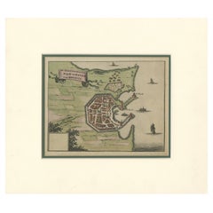
Dieppe – Antique Hand-Coloured French Coastal Town Engraving (1666)
$430.98
£322.30
€360
CA$593.87
A$647.90
CHF 343.06
MX$7,763.68
NOK 4,369.05
SEK 3,995.17
DKK 2,741.83
About the Item
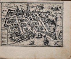
Dieppe – Antique Hand-Coloured French Coastal Town Engraving (1666)
This charming 17th-century copper engraving presents an early bird’s-eye plan of the fortified port town of Dieppe, published in Antwerp in 1666 for the atlas associated with the Fransche Merkurius. The engraving offers a detailed view of the harbour, surrounding fortifications, clustered townhouses with red-tiled roofs, and ships approaching from the Channel. The plan is rendered with crisp linework typical of mid-17th-century Flemish engraving, and enhanced with attractive period hand-colouring in shades of red, green, blue and ochre.
Small-format town plans from the Fransche Merkurius are valued for their clarity and historical charm, capturing European ports at a time when coastal trade, fortification engineering and maritime expansion shaped the geography of Northern France. Dieppe, one of the oldest French ports on the Channel, is shown with its early modern harbour structure and defensive works, making this a desirable piece for collectors of Normandy, French coastal history and early cartographic town views. The engraving is preserved with its full margins and retains strong decorative appeal.
Condition report:
Good condition. Image clean with bright hand-colouring. Foxing and age-toning visible in the margins, typical for 17th-century laid paper. Paper surface stable with no tears or losses affecting the printed area. Plate impression clear and well-defined.
Framing tips:
A walnut or light oak frame suits the warm tones of the hand-colouring and the age of the paper. A cream or ivory mat helps soften the marginal foxing while drawing focus to the colourful town plan. For a contemporary interior, a thin black frame with a white archival mat provides a crisp contrast.
Technique: Hand-coloured copper engraving
Maker: Published in Antwerp for Fransche Merkurius, 1666
- Dimensions:Height: 6.07 in (15.4 cm)Width: 8.63 in (21.9 cm)Depth: 0.01 in (0.2 mm)
- Materials and Techniques:Paper,Engraved
- Place of Origin:
- Period:1660-1669
- Date of Manufacture:1666
- Condition:Good condition. Image clean with bright hand-colouring. Foxing and age-toning visible in the margins, typical for 17th-century laid paper. Paper surface stable with no tears or losses affecting the printed area. Plate impression clear.
- Seller Location:Langweer, NL
- Reference Number:Seller: BG-14168-21stDibs: LU3054347806562
About the Seller
5.0
Recognized Seller
These prestigious sellers are industry leaders and represent the highest echelon for item quality and design.
Platinum Seller
Premium sellers with a 4.7+ rating and 24-hour response times
Established in 2009
1stDibs seller since 2017
2,792 sales on 1stDibs
Typical response time: <1 hour
- ShippingRetrieving quote...Shipping from: Langweer, Netherlands
- Return Policy
More From This Seller
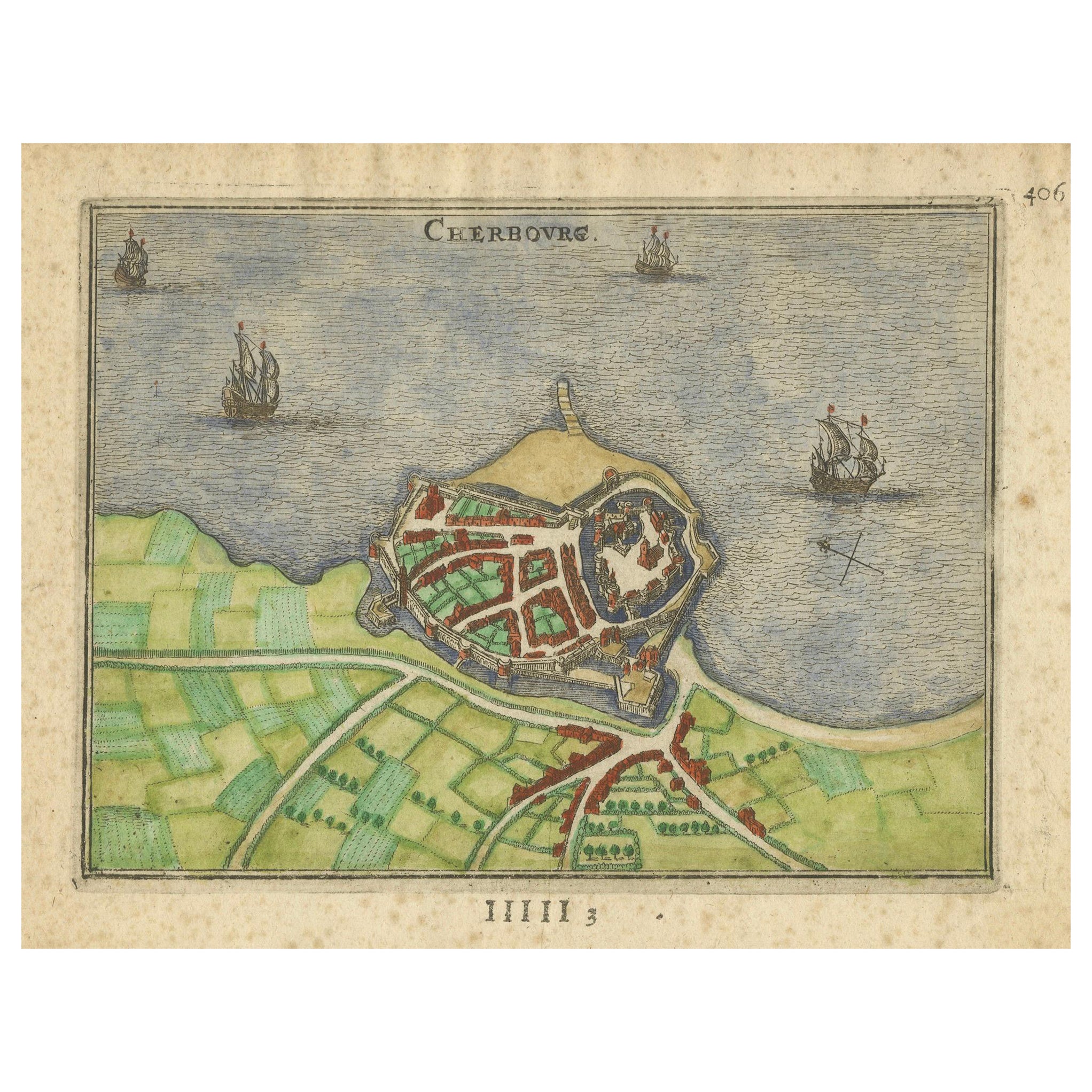
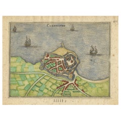
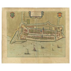
View AllCherbourg – Antique Hand-Coloured French Coastal Town Engraving (1666)
Located in Langweer, NL
Cherbourg – Antique Hand-Coloured French Coastal Town Engraving (1666)
This 17th-century copper engraving presents a finely detailed early plan of Cherbourg, published in Antwerp in...
Category
Antique 1660s Belgian Maps
Materials
Paper
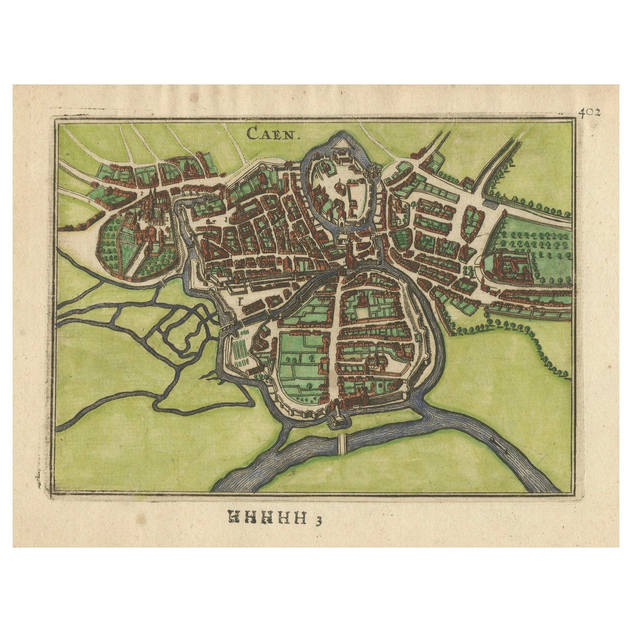
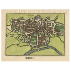
Caen – Antique Hand-Coloured Normandy Town Plan Engraving (1666)
Located in Langweer, NL
Caen – Antique Hand-Coloured Normandy Town Plan Engraving (1666)
This 17th-century copper engraving offers a finely detailed early plan of Caen, published in Antwerp in 1666 for the...
Category
Antique 1660s Belgian Maps
Materials
Paper
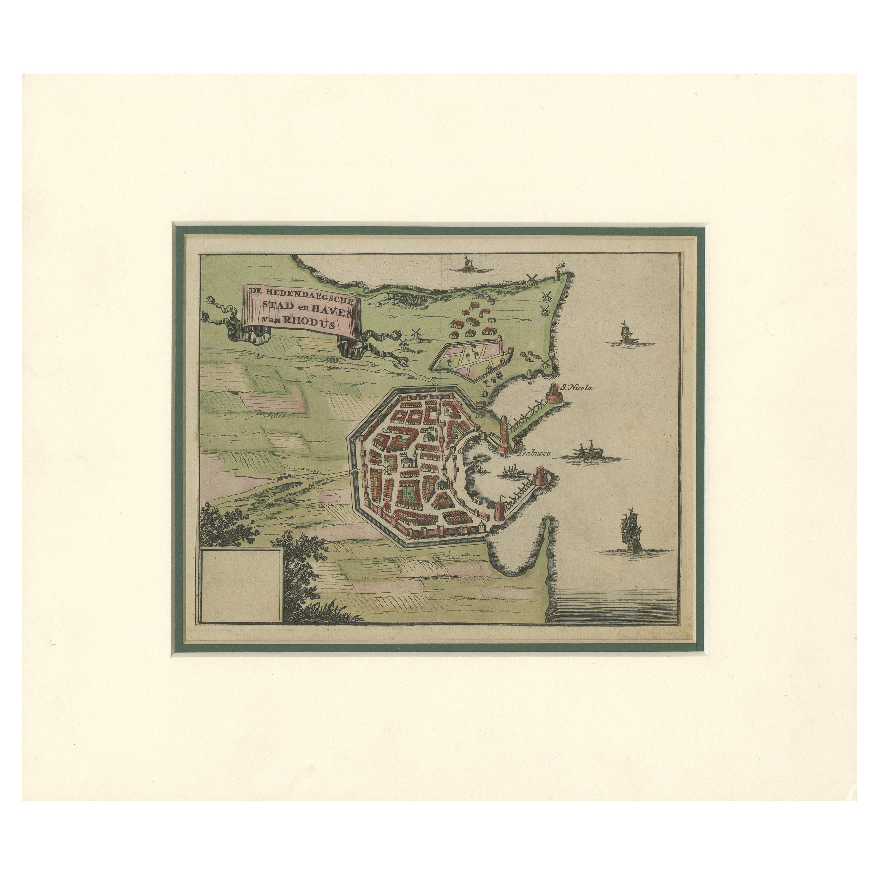
City and Harbour of Rhodes – Olfert Dapper, 1688 Hand-Coloured Engraving
Located in Langweer, NL
City and Harbour of Rhodes – Olfert Dapper, 1688 Hand-Coloured Engraving
Description:
This historical hand-coloured copperplate engraving, titled “De hedendaegsche Stad en Haven van...
Category
Antique Late 17th Century Dutch Maps
Materials
Paper
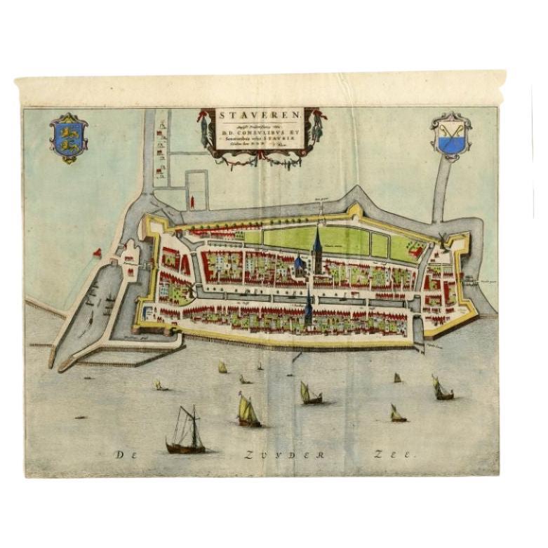
Antique Map of Stavoren by Blaeu, 1649
Located in Langweer, NL
Antique map titled 'Staveren'. Original antique map of the city of Stavoren, Friesland, The Netherlands. This map originates from 'Novum Ac Magnum Theatrum Urbium Belgicae Liberae Ac...
Category
Antique 17th Century Maps
Materials
Paper
$447 Sale Price
20% Off
Antique Map of Stavoren by Blaeu, 1649
Located in Langweer, NL
Antique map titled 'Staveren'. Original antique map of the city of Stavoren, Friesland, The Netherlands. This map originates from 'Toonneel der Steden van de Vereenighde Nederlanden'...
Category
Antique 17th Century Maps
Materials
Paper

$426 Sale Price
20% Off
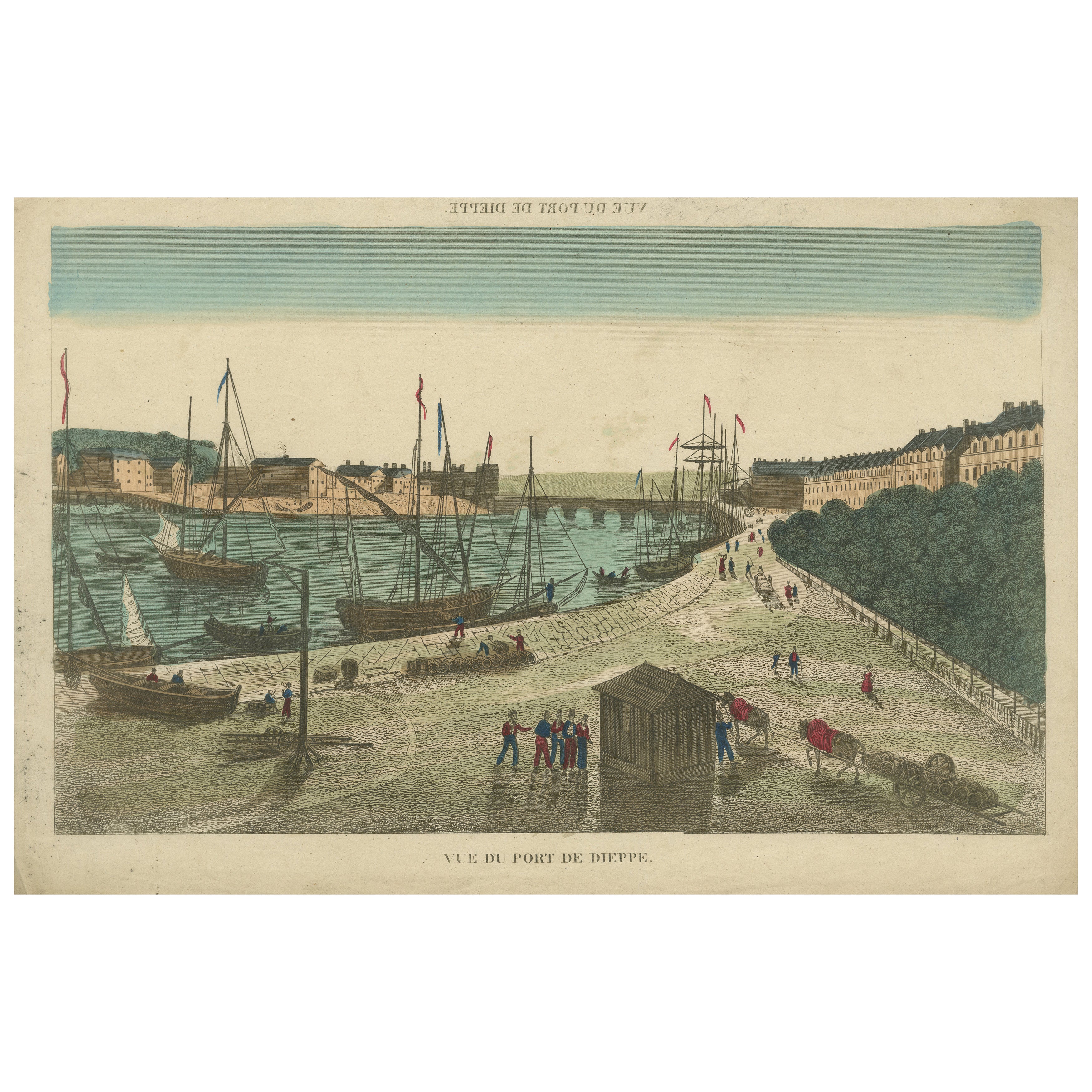
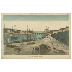
Vue du Port de Dieppe – Hand-Colored Optical Print, Paris, circa 1790
Located in Langweer, NL
Vue du Port de Dieppe – Hand-Colored Optical Print, Paris circa 1790
Description:
This engaging and finely hand-colored optical print titled 'Vue du Port de Dieppe' offers a vivid 1...
Category
Antique Late 18th Century French Prints
Materials
Paper
You May Also Like
17th Century Topographical Engraving Nantes
St. Malo, France, by Iohan Peeters
Located in New York, NY
The ancient city of Saint Malo in North Western France has long been associated with adventure on the high seas, piracy and exploration. It was the birthplace of several important in...
Category
Antique 17th Century Dutch Maps
Materials
Paper

View of Emden, Germany: A 16th Century Hand-colored Map by Braun
Hogenberg
By Franz Hogenberg
Located in Alamo, CA
This is a 16th century original hand-colored copperplate engraved map of a bird's-eye View of Embden, Germany entitled " Emuda, vulgo Embden vrbs Frisia orientalis primaria" by Georg Braun & Franz Hogenberg, in volume II of their famous city atlas "Civitates Orbis Terrarum", published in Cologne, Germany in 1575.
This is a beautifully colored and detailed map of Emden, a seaport in northwestern Germany, along the Ems River and perhaps portions of over Dollart Bay, near the border with the Netherland. The map depicts a bird's-eye view of the city from the southwest, as well as a view of the harbor and an extensive system of canals. Numerous ships of various sizes, as well as two rowboats containing numerous occupants are seen in the main waterway in the foreground and additional boats line two canals in the center of the city. Two men and two women are shown on a hill in the foreground on the right, dressed in the 16th century style of nobility. Two ornate crests are included in each corner. A title strap-work cartouche is in the upper center with the title in Latin. The crest on the right including Engelke up de Muer (The Little Angel on the Wall) was granted by Emperor Maximilian I in 1495.
This is an English translation of an excerpt of Braun's description of Embden: "In Emden, the capital of East Frisia, rich merchants live in very fine houses. The city has a broad and well-situated harbour, which in my opinion is unique in Holland. Frisia and the whole of the Netherlands, for the ships can anchor here right under the city walls. They have also extended the harbour as far as the New Town, so that up to 400 ships can now find shelter here when the sea is rough."
The emphasis on the harbor and waterways within the city highlights the importance of Emden's place as a seaport at this time. Embden developed from a Dutch/Flemish trading settlement in the 7th-8th centuries into a city as late as late 14th century. In 1494 it was granted staple rights, and in 1536 the harbour was extended. In the mid-16th century Emden's port was thought to have the most ships in Europe. Its population then was about 5,000, rising to 15,000 by the end of the 16th century. The Ems River flowed directly under the city walls, but its course was changed in the 17th century by the construction of a canal. Emden has canals within its city limits, a typical feature of Dutch towns, which also enabled the extension of the harbor. In 1744 Emden was annexed by Prussia and is now part of Germany. It was captured by French forces in 1757 during the Seven Years' War, but recaptured by Anglo-German forces in 1758. During the Napoleonic French era, Emden and the surrounding lands of East Frisia were part of the short-lived Kingdom of Holland.
References:Van der Krogt 4, 1230, State 2; Taschen, Braun and Hogenberg...
Category
16th Century Old Masters Landscape Prints
Materials
Engraving

Map of Embden - Original Etching by G. Braun e F. Hogenberg - Late 16th Century
By Franz Hogenberg
Located in Roma, IT
This map of Embdena is an original etching realized by George Braun and Franz Hogenberg in the Late 16th Century, as part of the famous Series "Civitates Orbis Terrarum" (Atlas of t...
Category
16th Century Figurative Prints
Materials
Etching

18th Century Map Engraving - Newport, a Strong Sea-Port Town in Flanders
Located in Corsham, GB
A map of Nieuwpoort, anglicised to 'Newport', in northern Belgium. There is a panorama in the upper quarter depicting major landmarks. Below is a plan of the town, including its strong defences and ships at the port in the lower register. Inscribed with the title in plate to the lower edge, 'Newport a Strong Sea-Port Town...
Category
18th Century More Prints
Materials
Engraving

$269 Sale Price
20% Off
Map of Antwerp - Etching by G.Braun and F. Hogenberg -Late 16th century
By Franz Hogenberg
Located in Roma, IT
This Map of Anverpia is an original etching hand colored realized by George Braun and Franz Hogenberg as part of the famous Atlas "Civitates Orbis Ter...
Category
16th Century Old Masters Figurative Prints
Materials
Etching

Map of Burdegalen - Original Etching by George Braun - 1575 ca.
Located in Roma, IT
This Burdegalen is an original etching realized in about 1575 by George Braun (1541 – 1622)
The state of preservation of the artwork is good and aged on the edges of the sheet with...
Category
16th Century More Prints
Materials
Etching