Items Similar to Dutch Municipality of the Gemeente Oldehove in Grongingen, Kuyper, 1865
Want more images or videos?
Request additional images or videos from the seller
1 of 5
Dutch Municipality of the Gemeente Oldehove in Grongingen, Kuyper, 1865
$114.93
$143.6620% Off
£85.95
£107.4320% Off
€96
€12020% Off
CA$158.37
CA$197.9620% Off
A$172.77
A$215.9720% Off
CHF 91.48
CHF 114.3520% Off
MX$2,070.32
MX$2,587.8920% Off
NOK 1,165.08
NOK 1,456.3520% Off
SEK 1,065.38
SEK 1,331.7220% Off
DKK 731.15
DKK 913.9420% Off
About the Item
Groningen: Gemeente Kommerzijl, Oldehove, Niehove, Saaksum. These scarse detailed maps of Dutch Towns originate from the 'Gemeente-atlas' of Jacob Kuyper. This atlas of all towns in the Netherlands was published from 1865-1870 and included all towns in the Dutch province of Groningen. These maps are also known as a Kuyper kaart or Kuyper kaartjes from Groningen. Nowadays it is a village in the gemeente of Westerkwartier.
Artists and Engravers: Author: Jacob Kuyper: He was one of the most important of the Dutch atlas editors of the second half of the 19th century. He is particularly known for the ""Gemeente Atlas"", with 1210 plans of all the towns and villages in the Netherlands.
Technic: Lithograph with later handcolouring. We also carry the original border coloured maps.
Condition: Fine; occasional foxing as visible on the scans; sheet irregularly cut, not affecting image.
Date: 1865
Overall size: 8.7 x 7.1 inch
Image size: 0.001 x 7.9 x 5.9 inch
We sell original antique maps to collectors, historians, educators and interior decorators all over the world. Our collection includes a wide range of authentic antique maps from the 16th to the 20th centuries. Buying and collecting antique maps is a tradition that goes back hundreds of years. Antique maps have proved a richly rewarding investment over the past decade, thanks to a growing appreciation of their unique historical appeal. Today the decorative qualities of antique maps are widely recognized by interior designers who appreciate their beauty and design flexibility. Depending on the individual map, presentation, and context, a rare or antique map can be modern, traditional, abstract, figurative, serious or whimsical. We offer a wide range of authentic antique maps for any budget.
- Dimensions:Height: 7.1 in (18.04 cm)Width: 8.7 in (22.1 cm)Depth: 0.001 in (0.03 mm)
- Materials and Techniques:
- Period:
- Date of Manufacture:1865
- Condition:
- Seller Location:Langweer, NL
- Reference Number:Seller: PCT-186651stDibs: LU3054325636012
About the Seller
5.0
Recognized Seller
These prestigious sellers are industry leaders and represent the highest echelon for item quality and design.
Platinum Seller
Premium sellers with a 4.7+ rating and 24-hour response times
Established in 2009
1stDibs seller since 2017
2,792 sales on 1stDibs
Typical response time: <1 hour
- ShippingRetrieving quote...Shipping from: Langweer, Netherlands
- Return Policy
More From This Seller
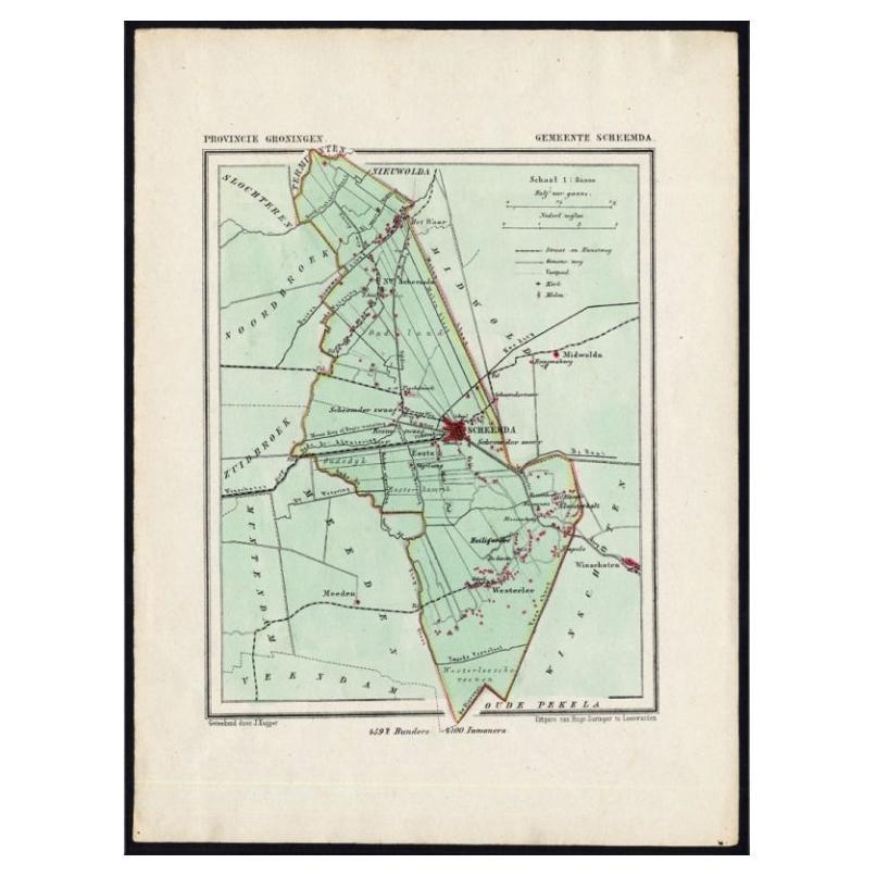
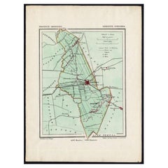
View AllDutch Municipality of Scheemda in Groningen, Kuyper, 1865
Located in Langweer, NL
Groningen: Gemeente Heiligerlee, Scheemda, Nieuw Scheemda, Westerlee. These scarse detailed maps of Dutch Towns originate from the 'Gemeente-atlas' of Jacob Kuyper. This atlas of all...
Category
Antique 19th Century Maps
Materials
Paper
$105 Sale Price
20% Off
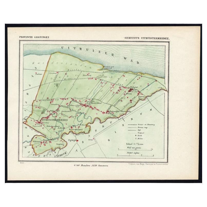
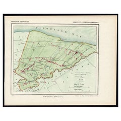
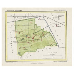
Dutch Municipality of Uithuizermeeden in Groningen, Kuyper, 1865
Located in Langweer, NL
Groningen: Gemeente Oldenzijl, Oosternieland, de Roode School, Uithuizermeeden. These scarse detailed maps of Dutch Towns originate from the 'Gemeente-atlas' of Jacob Kuyper. This at...
Category
Antique 19th Century Maps
Materials
Paper
$105 Sale Price
20% Off
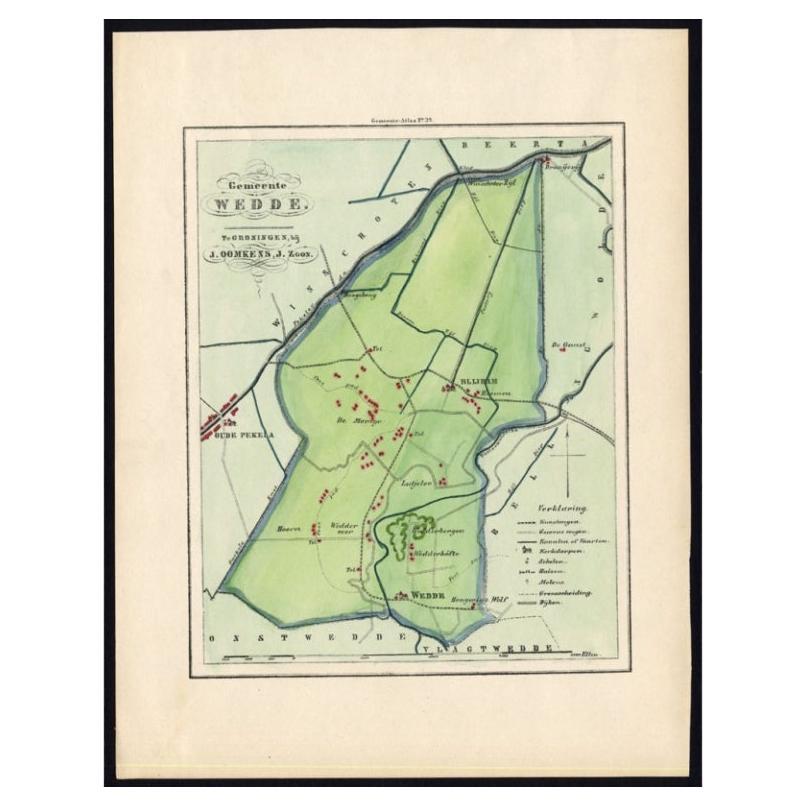
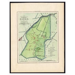
Dutch Municipality of Wedde in Groningen, Fehse, 1862
Located in Langweer, NL
These scarse detailed maps of Dutch Towns originate from the 'Gemeente atlas van de Provincie Groningen in 62 kaarten.' by C. Fehse. This atlas of all towns in Groningen, the Netherl...
Category
Antique 19th Century Maps
Materials
Paper
$114 Sale Price
20% Off
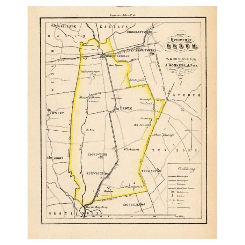
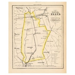
Dutch Municipality of Bedum in Groningen, Fehse, 1862
Located in Langweer, NL
These scarse detailed maps of Dutch Towns originate from the 'Gemeente atlas van de Provincie Groningen in 62 kaarten.' by C. Fehse. This atlas of all towns in Groningen, the Netherl...
Category
Antique 19th Century Maps
Materials
Paper
$114 Sale Price
20% Off
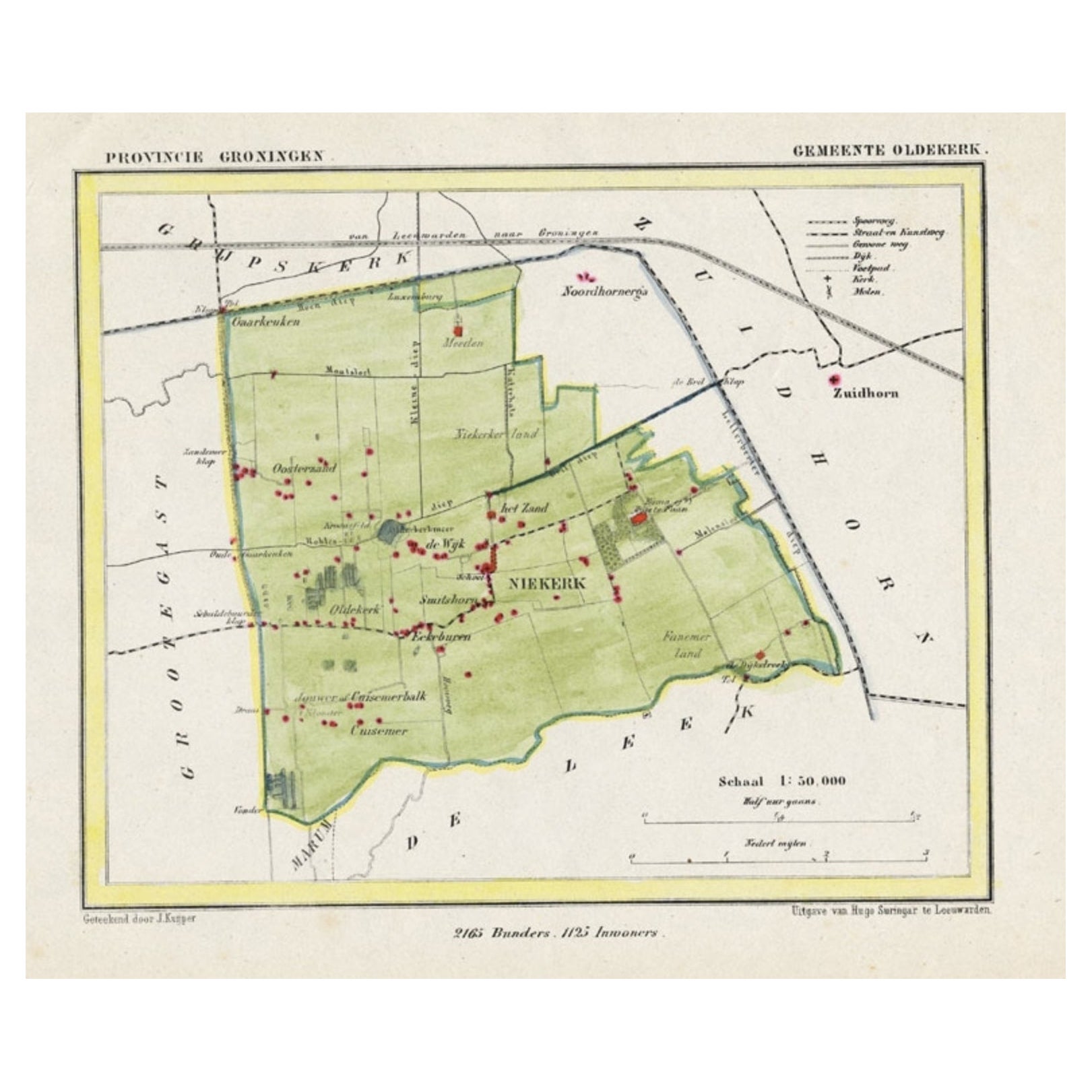
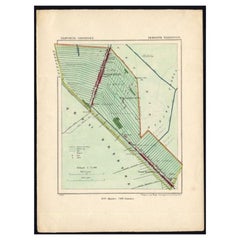
Dutch Municipality of Oldekerk in Groningen, The Netherlands, 1865
Located in Langweer, NL
Groningen: Gemeente Niekerk, Oldekerk.
These scarse detailed maps of Dutch Towns originate from the 'Gemeente-atlas' of Jacob Kuyper. This atlas of all towns in the Netherlands w...
Category
Antique 19th Century Maps
Materials
Paper
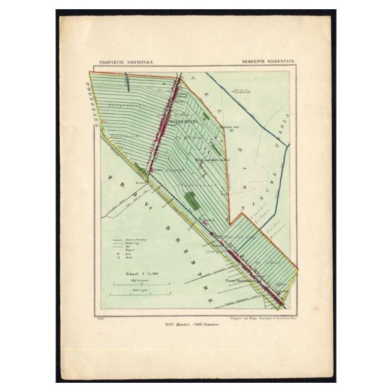
Dutch Municipality of Wildervank in Grongingen, Kuyper, 1865
Located in Langweer, NL
Groningen: Gemeente Nieuw Stadskanaal, Wildervank. These scarse detailed maps of Dutch Towns originate from the 'Gemeente-atlas' of Jacob Kuyper. This atlas of all towns in the Nethe...
Category
Antique 19th Century Maps
Materials
Paper
$114 Sale Price
20% Off
You May Also Like
Original Antique English County Map, Huntingdonshire, J
C Walker, 1851
Located in St Annes, Lancashire
Great map of Huntingdonshire
Original colour
By J & C Walker
Published by Longman, Rees, Orme, Brown & Co. 1851
Unframed.
Category
Antique 1850s English Other Maps
Materials
Paper

Original Antique English County Map, Cambridgeshire, J
C Walker, 1851
Located in St Annes, Lancashire
Great map of Cambridgeshire
Original colour
By J & C Walker
Published by Longman, Rees, Orme, Brown & Co. 1851
Unframed.
Category
Antique 1850s English Other Maps
Materials
Paper

Original Antique English County Map, Buckinghamshire, J
C Walker, 1851
Located in St Annes, Lancashire
Great map of Buckinghamshire
Original colour
By J & C Walker
Published by Longman, Rees, Orme, Brown & Co. 1851
Unframed.
Category
Antique 1850s English Other Maps
Materials
Paper

Original Antique English County Map, Nottinghamshire, J
C Walker, 1851
Located in St Annes, Lancashire
Great map of Nottinghamshire
Original colour
By J & C Walker
Published by Longman, Rees, Orme, Brown & Co. 1851
Unframed.
Category
Antique 1850s English Other Maps
Materials
Paper

Original Antique English County Map, Derbyshire, J
C Walker, 1851
Located in St Annes, Lancashire
Great map of Derbyshire
Original colour
By J & C Walker
Published by Longman, Rees, Orme, Brown & Co. 1851
Unframed.
Category
Antique 1850s English Other Maps
Materials
Paper

Original Antique English County Map, Leicestershire, J
C Walker, 1851
Located in St Annes, Lancashire
Great map of Leicestershire
Original colour
By J & C Walker
Published by Longman, Rees, Orme, Brown & Co. 1851
Unframed.
Category
Antique 1850s English Other Maps
Materials
Paper

More Ways To Browse
Antique Map Of Egypt
Map Of Austria
New Zealand Map
Antique Linen Map
19th Century World Map
Antique Ohio Maps
Antique Texas Furniture
Military Map
Antique Maps New Zealand
Birds Eye View Map
North Africa Map
West Africa Map
Antique Compass Map
Antique Maps California
Biblical Maps
Hungary Map
Maps Of Mediterranean
Treasure Map