Items Similar to Dutch Republic
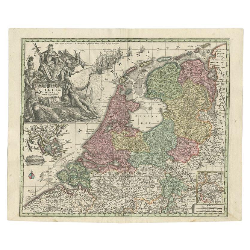
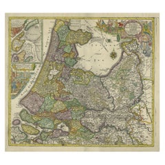
East Indies, Belgium Foederatum Map by Seutter, 18th Century

Want more images or videos?
Request additional images or videos from the seller
1 of 11
Dutch Republic
East Indies, Belgium Foederatum Map by Seutter, 18th Century
$1,174.69
£876.96
€990
CA$1,632
A$1,755.45
CHF 938.16
MX$20,691.76
NOK 11,828.05
SEK 10,813.08
DKK 7,544.91
About the Item
Dutch Republic
East Indies, Belgium Foederatum Map by Seutter, 18th Century
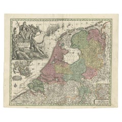
This impressive antique map titled Belgium Foederatum Auctius Et Emendatius depicts the Seven United Provinces of the Dutch Republic at the height of their political and commercial power. The map was created by Matthaeus Seutter, one of the leading German cartographers of the early 18th century, and published in Augsburg as part of his influential atlas production.
The main map presents the northern Netherlands in exceptional detail, clearly delineating provincial borders, major cities, rivers, and waterways. The geography reflects the Dutch Republic as a sovereign entity, emphasizing its unity and independence. Original outline hand coloring enhances the visual clarity of the provinces and gives the map strong decorative appeal, particularly when viewed at wall scale.
A richly engraved allegorical title cartouche occupies a prominent position and features the coat of arms of the Seven United Provinces, surrounded by symbolic figures representing authority, prosperity, and statehood. This elaborate cartouche is a hallmark of Seutter’s work and elevates the map from a purely geographic document to a statement of political identity and national pride.
Of particular interest are the inset maps. One inset focuses on the region of Limburg, while another traces the Dutch maritime trade route to the East Indies, illustrating the global reach of the Dutch Republic. This route map encompasses key regions including India, Indonesia, China, and Japan, visually reinforcing the importance of overseas trade and colonial networks in Dutch economic dominance. The inclusion of the East Indies makes this map especially relevant for collectors and interiors with a connection to Dutch colonial or Asian history.
Engraved on copper and printed with fine precision, this map exemplifies the high technical and artistic standards of Augsburg mapmaking in the early 18th century. Today, it is sought after not only by collectors of Dutch and European cartography, but also by interior designers looking for a large, historically rich wall map with strong decorative presence and global narrative.
Condition report:
Original copper engraving with original outline hand coloring. Light, even age toning throughout. Minor spotting and handling marks consistent with age. Central fold as issued. Margins generally ample. Overall in good, attractive condition.
Framing tips:
This map is ideally framed in dark walnut, antique black, or ebonized wood with a wide ivory or linen-toned mat. Museum or UV-filtering glass is recommended. Particularly effective as a statement piece in a study, library, or refined modern interior.
Technique: Copper engraving with original hand coloring
Maker: Matthaeus Seutter, Augsburg, early 18th century
- Dimensions:Height: 20.87 in (53 cm)Width: 25.2 in (64 cm)Depth: 0.01 in (0.2 mm)
- Materials and Techniques:Paper,Engraved
- Place of Origin:
- Period:
- Date of Manufacture:circa 1730
- Condition:Original copper engraving with original outline hand coloring. Light, even age toning throughout. Minor spotting and handling marks consistent with age. Central fold as issued. Margins generally ample. Overall in good, attractive condition.
- Seller Location:Langweer, NL
- Reference Number:Seller: BG-141431stDibs: LU3054348269172
About the Seller
5.0
Recognized Seller
These prestigious sellers are industry leaders and represent the highest echelon for item quality and design.
Platinum Seller
Premium sellers with a 4.7+ rating and 24-hour response times
Established in 2009
1stDibs seller since 2017
2,836 sales on 1stDibs
Typical response time: 1 hour
- ShippingRetrieving quote...Shipping from: Langweer, Netherlands
- Return Policy
More From This Seller
View AllAntique Map of the Netherlands and Belgium by Homann, circa 1710
By Johann Baptist Homann
Located in Langweer, NL
Antique map titled 'Tabula Generalis Totius Belgii Provinciae XVII. Infer. Germaniae (..)'. Map of the Benelux countries by Johann Baptist Homann. Shows the area between the Seine es...
Category
Antique Early 18th Century German Maps
Materials
Paper

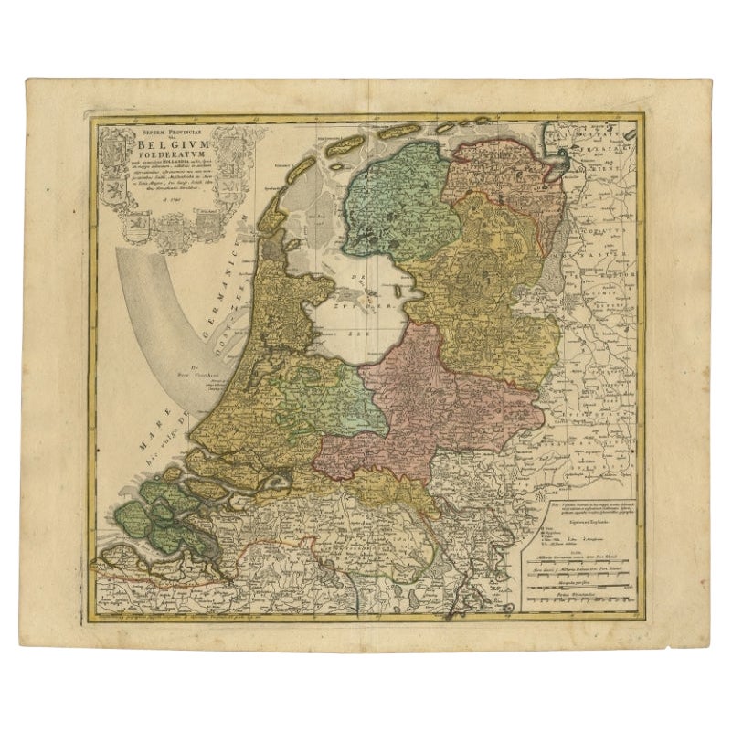
Detailed Old Map of the Seven Provinces of the Belgian/Dutch Federation, ca.1748
Located in Langweer, NL
Antique map titled 'Septem Provinciae seu Belgium Foederatum quod generliter Hollandia (..).' Detailed antique map of the seven provinces of the Belgian Federation (Dutch Federation)...
Category
Antique 18th Century Maps
Materials
Paper
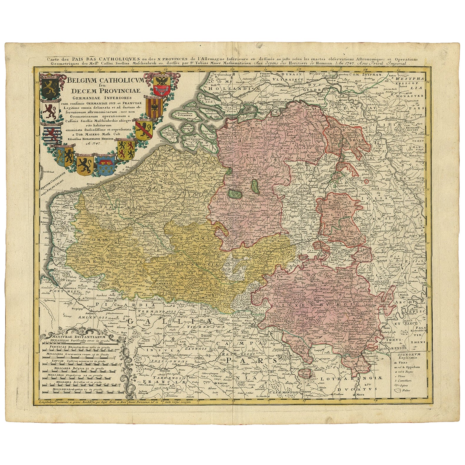
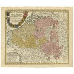
Antique Map of Belgium and Luxembourg by Homann Heirs, 1747
Located in Langweer, NL
Antique map titled 'Belgium Catholicum seu Decem provinciae Germaniae Inferioris cum confiniis Germaniae sup. et Francia (..).' Detailed map of Belgium and Luxembourg showing parts o...
Category
Antique 18th Century Maps
Materials
Paper
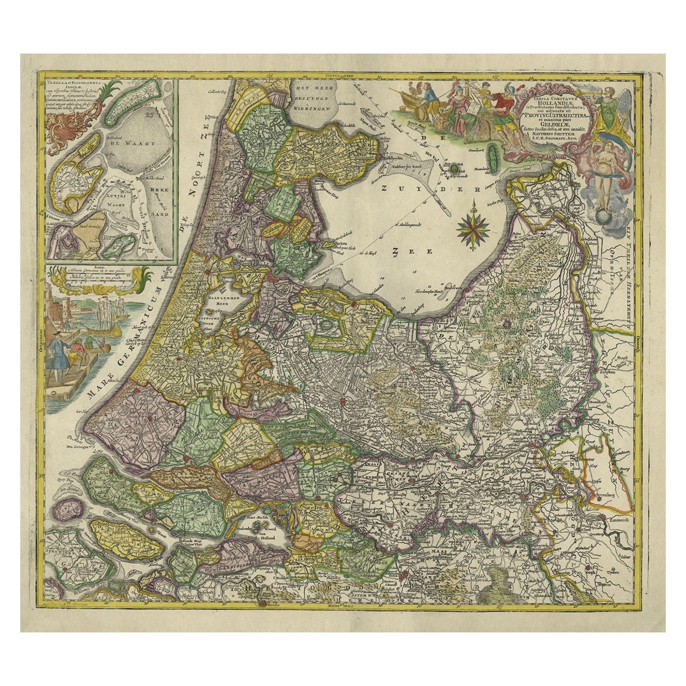
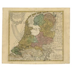
Antique Map of the Northwestern Netherlands, incl Texel and Vlieland, ca.1741
Located in Langweer, NL
Antique print, titled: 'Tabula Comitatus Hollandiae in Praefecturas sua distributa; cui adjuncta est Provinc. Ultraiectina et maxima pars Geldriae summo studio delin. Et aeri incidit...
Category
Antique 1740s German Maps
Materials
Paper
$892 Sale Price
20% Off
Antique Map of the Seven United Provinces of Holland by Seutter, 1727
Located in Langweer, NL
Antique map titled ‘Belgium Foederatum Auctius Et Emendatius‘. Important antique map of the Seven United Provinces of Holland with inset views of the East Indies, the province of Lim...
Category
Antique 18th Century Maps
Materials
Paper
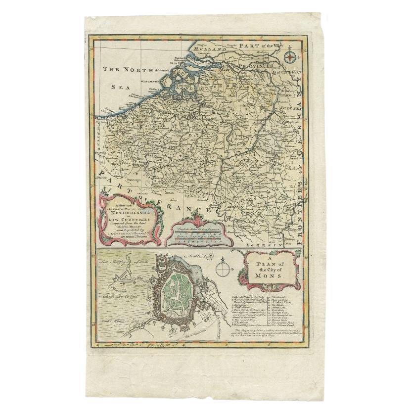
Antique Map of the Netherlands and Belgium by Bowen, 1747
By Emanuel Bowen
Located in Langweer, NL
Antique map Belgium titled 'A New and Accurate Map of the Netherlands or Low Countries'. Detailed map of South of the Netherlands and Belgium. With large inset of the city of Mons, B...
Category
Antique 18th Century Maps
Materials
Paper
You May Also Like
North Holland, Netherlands: A Large 17th C. Hand-colored Map by Sanson
Jaillot
By Nicholas Sanson d
Abbeville
Located in Alamo, CA
This large hand-colored map entitled "Le Comte De Hollande Dressee sur les Memoires les plus Nouveaux" was originally created by Nicholas Sanson d'Abbeville. This version was publish...
Category
1690s Landscape Prints
Materials
Engraving

1643 Willem&Joan Blaeu Map NW Flanders "Flandriae Teutonicae Pars Prientalior
Located in Norton, MA
1643 Willem and Joan Blaeu map of northwest Flanders, entitled
"Flandriae Teutonicae Pars Prientalior,"
Ric0012
" Authentic" - Map of the northwest Fl...
Category
Antique 17th Century Dutch Maps
Materials
Paper

Belgium and the Netherlands: A Hand-colored 17th Century Map by Visscher
By Nicolaus Visscher
Located in Alamo, CA
This is an original hand-colored 17th century map of Belgium by Nicolaus (Nicolas) Visscher II entitled "Belgium Foederatum emendate auctum et novissime editum", published in Amsterdam in 1678. The map shows the seven provinces comprising the Belgium federation or the Republic of the Seven United Netherlands or the Dutch Republic as it was also known. The republic was formed when an alliance of seven Dutch provinces in the Spanish Netherlands revolted against rule by Spain in 1579 (the Union of Utrecht) and declared their independence in 1581 (the Act of Abjuration). The seven provinces were Groningen, Frisia, Overijssel, Guelders, Utrecht, Holland and Zeeland. This was a predecessor state to the Netherlands and the first fully independent Dutch nation state. Amsterdam, Delft, Rouen, Utrecht, Brugge, Ghent, and Antwerp are all included on the map. A small inset map in the lower right depicts the course of the Maas River from Maastricht to Wessem. There is a decorative cartouche in the upper left corner and a distance scale cartouche in the lower right corner.
The map is presented in an attractive antiqued medium brown-colored wood frame with gold-colored inner and outer trim and a light tan-colored fabric mat. The frame measures 26.63" high by 30" wide by 0.75" deep. There is some darkening of the red areas in the map, presumably related to oxidation of the original iron containing pigment over time. There are also a few scattered spots. The map is otherwise in very good condition.
The Visscher family were one of the great cartographic families of the 17th century. Begun by Claes Jansz Visscher...
Category
Late 17th Century Other Art Style Landscape Prints
Materials
Engraving

1752 Vaugoundy Map of Flanders : Belgium, France, and the Netherlands, Ric.a002
Located in Norton, MA
Large Vaugoundy Map of Flanders:
Belgium, France, and the Netherlands
Colored -1752
Ric.a002
Description: This is a 1752 Didier Robert de Vaugondy map of Flanders. The map de...
Category
Antique 17th Century Unknown Maps
Materials
Paper

The Netherlands (Holland), Belgium and Luxemburg. Century Atlas antique map
Located in Melbourne, Victoria
'The Century Atlas. The Netherlands (Holland), Belgium and Luxemburg.'
Original antique map, 1903.
Inset maps of 'Amsterdam' and 'Brussels'.
Central fold as issued. Map name and num...
Category
Early 20th Century Victorian More Prints
Materials
Lithograph

Matthaus Seutter, Framed 1730 Color Engraving Map of "Belgium Fonderatum"
Located in Bridgeport, CT
Label on verso. From Grosser Atlas. The name Belgium comes from the ancient designation "Gallis Belgica". Figural decoration upper left. M. Seutter was a famed German mapmaker in the...
Category
Antique 18th Century European Renaissance Maps
Materials
Brass
