Items Similar to Early 18th Century Map of Denmark in Old Coloring, Published in 1706


Want more images or videos?
Request additional images or videos from the seller
1 of 9
Early 18th Century Map of Denmark in Old Coloring, Published in 1706
$680
$85020% Off
£517.25
£646.5620% Off
€596.23
€745.2920% Off
CA$965.46
CA$1,206.8220% Off
A$1,036.15
A$1,295.1920% Off
CHF 555.42
CHF 694.2720% Off
MX$12,469.61
MX$15,587.0120% Off
NOK 7,003
NOK 8,753.7520% Off
SEK 6,385.77
SEK 7,982.2120% Off
DKK 4,453.87
DKK 5,567.3420% Off
About the Item
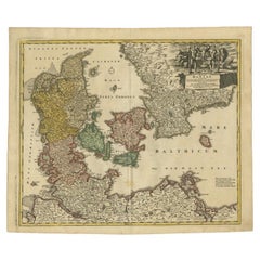
Denmark. Schenk (Petrus), Dania Regnum Ducatus Holsatia. et Slesvicum Insulae Danicae et Provinciae Jutia Scania etc. Amsterdam, 1706, engraved reticulated map on thick paper with contemporary hand-colouring, 490 x 590 mm.
- Dimensions:Height: 19.3 in (49 cm)Width: 23.23 in (59 cm)Depth: 0 in (0.02 mm)
- Materials and Techniques:Paper,Engraved
- Period:1700-1709
- Date of Manufacture:1706
- Condition:
- Seller Location:Langweer, NL
- Reference Number:Seller: BG-13101-11stDibs: LU3054325927762
About the Seller
5.0
Recognized Seller
These prestigious sellers are industry leaders and represent the highest echelon for item quality and design.
Platinum Seller
Premium sellers with a 4.7+ rating and 24-hour response times
Established in 2009
1stDibs seller since 2017
2,830 sales on 1stDibs
Typical response time: 1 hour
- ShippingRetrieving quote...Shipping from: Langweer, Netherlands
- Return Policy
More From This Seller
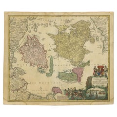
View AllAntique Map of Denmark with Details of Fortresses, Cities, Towns Etc, c.1680
Located in Langweer, NL
Antique map of Denmark titled 'Insularum Danicarum ut Zee-Landiae, Fioniae, Langelandiae, Lalandiae Falstriae, Fembriae, Monae (..)'. This map depicts the main Danish Islands and a s...
Category
Antique 17th Century Maps
Materials
Paper

Map of Denmark Divided into Dioceses – G.
L. Valk, ca. 1690
Located in Langweer, NL
Map of Denmark Divided into Dioceses – G. & L. Valk, ca. 1700
Detailed antique map titled "Regnum Daniae, divisum in Dioeceses Arhusiam, Albergum, Viborgum, et Ripam," showing Denma...
Category
Antique Late 17th Century Maps
Materials
Paper

$522 Sale Price
20% Off
Antique Map of Denmark by F. de Wit, 1680
Located in Langweer, NL
Antique map titled 'Dania Regnum'. Large, attractive map of Denmark, Sleschwig-Holstein and southern Sweden. Good detail throughout. Embellished with a title cartouche with the Danis...
Category
Antique Late 17th Century Maps
Materials
Paper

Antique Map of Denmark with Schleswig-Holstein and the South of Sweden, c.1750
Located in Langweer, NL
Antique map titled 'General Charte von Konigreich Daenemark nebst dem Herzogthum Holstein.' Denmark with Schleswig-Holstein and the southern coast of Sweden. The large title cartouch...
Category
Antique 18th Century Maps
Materials
Paper

Antique Map of Denmark with the Danish Royal Crest, c.1730
By Homann Heirs
Located in Langweer, NL
Antique map titled 'Regni Daniae in quo sunt Ducatus Holsatia and Slesuicum Insulae Danicae Jutia, Scania Blekingia (..).' Map of Denmark and islands, part of Sweden and Germany, dra...
Category
Antique 18th Century Maps
Materials
Paper
Antique Map of the Islands of Denmark by Homann Heirs, 1720
Located in Langweer, NL
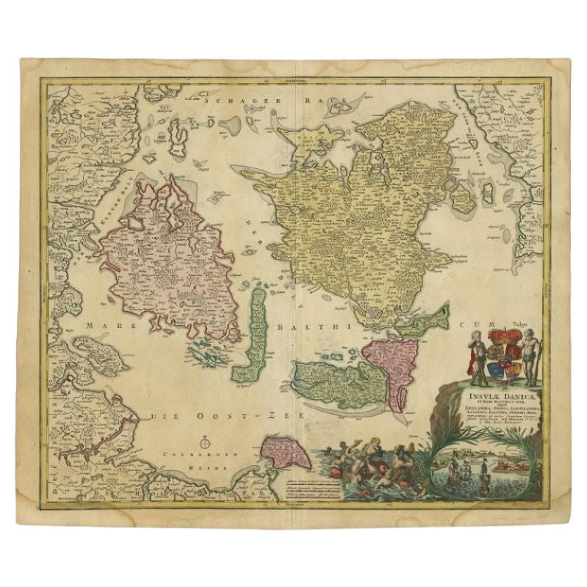
Antique map titled 'Insula Danicae in Mari Balthico sitae (..).' - Map of the Danish islands situated in the Baltic Sea by J. B. Homann, (after J. Hübner's map of the region ) with g...
Category
Antique 18th Century Maps
Materials
Paper
You May Also Like
Hand-Colored 18th Century Homann Map of Denmark and Islands in the Baltic Sea
By Johann Baptist Homann
Located in Alamo, CA
An 18th century copper plate hand-colored map entitled "Insulae Danicae in Mari Balthico Sitae utpote Zeelandia, Fionia, Langelandia, Lalandia, Falstria, Fembria Mona" created by Joh...
Category
Antique Early 18th Century German Maps
Materials
Paper

17th Century Map of Denmark by French Cartographer Sanson, Dated 1658
By Nicolas Sanson
Located in Copenhagen, K
17th century map of Denmark by French cartographer Sanson.
Nicolas Sanson (20 December 1600-7 July 1667) was a French cartographer, termed by some the creator of French geography an...
Category
Antique 17th Century French Maps
Materials
Paper

Map of Denmark, 1724
Located in Houston, TX
Extraordinary copper engraved map of Denmark by cartographer Christoph Weigel from 1724. Shows counties, rivers and towns. Ornate title cartouche. Original hand-color. Over 250 years old.
Original antique map displayed...
Category
17th Century Other Art Style More Prints
Materials
Paper, Ink, Watercolor

Scandinavia
Portions of Eastern Europe: 18th Century Hand-Colored Homann Map
By Johann Baptist Homann
Located in Alamo, CA
An early 18th century hand-colored copper-plate map entitled "Regni Sueciae in omnes suas Subjacentes Provincias accurate divisi Tabula Generalis" by Johann Baptist Homann (1663-1724...
Category
Antique Early 18th Century German Maps
Materials
Paper

18th Century Hand-Colored Homann Map of Germany, Including Frankfurt and Berlin
By Johann Baptist Homann
Located in Alamo, CA
An 18th century hand-colored map entitled "Tabula Marchionatus Brandenburgici et Ducatus Pomeraniae quae sunt Pars Septentrionalis Circuli Saxoniae Superioris" by Johann Baptist Homa...
Category
Antique Early 18th Century German Maps
Materials
Paper

1646 Jansson Map Entitled "Procinvia Connactiae, " Ric.a006
Located in Norton, MA
1646 Jansson map entitled
"Procinvia connactiae,"
Ric.a006
Description: The PROVINCE of CONNAVGT 490 x 380From vol 4 of Jansson's Atlas Novus 1646, published in Amsterdam with...
Category
Antique 17th Century Unknown Maps
Materials
Paper

More Ways To Browse
Antique Texas Furniture
Military Map
Antique Maps New Zealand
Birds Eye View Map
North Africa Map
West Africa Map
Antique Compass Map
Antique Maps California
Biblical Maps
Hungary Map
Maps Of Mediterranean
Treasure Map
Antique Navigational Tools
Mississippi Furniture
Caribbean Antiques
Antique Maps West Indies
Antique Mozambique
Malaysian Antique Furniture