Items Similar to Early Woodcut Map of the Rhine River Region in Germany and Holland, circa 1628


Want more images or videos?
Request additional images or videos from the seller
1 of 7
Early Woodcut Map of the Rhine River Region in Germany and Holland, circa 1628
$576.43
£426.93
€480
CA$788.53
A$858.16
CHF 454.91
MX$10,324.33
NOK 5,769.72
SEK 5,278.89
DKK 3,657.68
About the Item
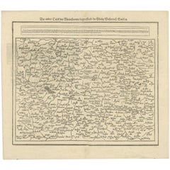
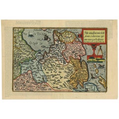
Early Woodcut Map of the Rhine River Region, "Die Dritte Tafel des Rheinstroms," ca. 16th Century
This early woodcut map, titled "Die Dritte Tafel des Rheinstroms Innhaltend das Nider Teutschlandt," offers a fascinating depiction of the Rhine River region, covering areas between Namur, Bonn, Amsterdam, and Rotterdam. The map dates to the 16th century and highlights the river's path through numerous significant cities and towns.
The map is adorned with various inscriptions and decorative elements that enhance its historical value. The detailed depiction includes major waterways, settlements, and natural features, which convey a clear picture of the geography of the Lower Rhineland. Such woodcut maps were instrumental in providing geographical information during the Renaissance, reflecting the craftsmanship of early cartographers.
Here are the translations for the text blocks:
1. First Text Block:
"The other branch of the Rhine continues and splits near Arnhem. One part is called the Yssel, flows past Deventer, and empties into the Southern Sea near Kampen. The middle course retains the name Rhine until Wageningen, where some call it the Lek. There are 62 other streams flowing into the Rhine."
2. Second Text Block:
"This is the third map of the Rhine, in which you can see how it flows from Cologne through the Netherlands, passing through the bishoprics of Cologne, Westphalia, Cleves, Gelderland, and Holland, and empties into the sea, and how the Meuse flows from Namur into the sea near Liège."
3. Third Text Block:
"But here the Rhine splits into two parts below Emmerich. One part loses its name and is called the Waal, flows next to the Meuse past Nijmegen, and empties into the sea above the town of Gorinchem."
This map is not only an invaluable historical document but also a work of art, with its ornate borders and flowing calligraphy that add to its aesthetic appeal. It captures the essence of early cartographic representation, with an emphasis on both artistic detail and functional geography.
Condition report: Well-preserved with minor toning consistent with age. The print is crisp, and the details remain clear, with slight foxing in the margins. Overall, it is a charming and well-kept example of early cartography.
- Dimensions:Height: 14.45 in (36.7 cm)Width: 16.26 in (41.3 cm)Depth: 0.01 in (0.2 mm)
- Materials and Techniques:Paper,Engraved
- Period:1620-1629
- Date of Manufacture:1628
- Condition:Condition report: Very good. Well-preserved with minor toning consistent with age. The print is crisp, and the details remain clear, with slight foxing in the margins. Overall, it is a charming and well-kept example of early cartography.
- Seller Location:Langweer, NL
- Reference Number:Seller: BG-13842-71stDibs: LU3054342576082
About the Seller
5.0
Recognized Seller
These prestigious sellers are industry leaders and represent the highest echelon for item quality and design.
Platinum Seller
Premium sellers with a 4.7+ rating and 24-hour response times
Established in 2009
1stDibs seller since 2017
2,816 sales on 1stDibs
Typical response time: 1 hour
- ShippingRetrieving quote...Shipping from: Langweer, Netherlands
- Return Policy
More From This Seller
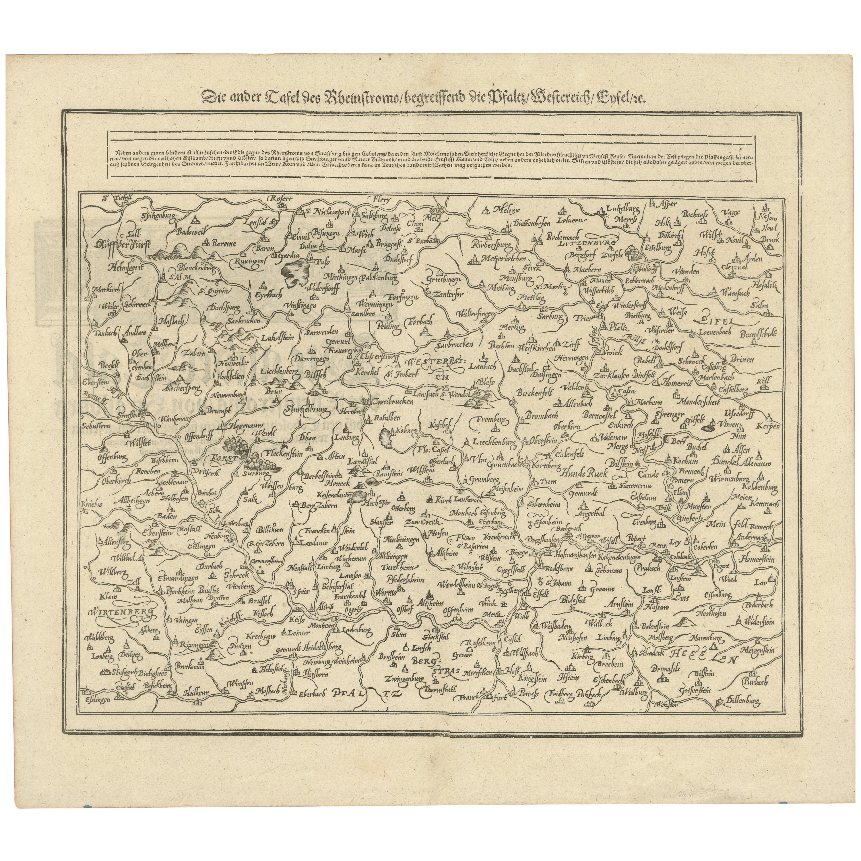
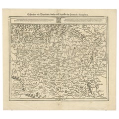
View AllWoodcut Map of the Rhine River Region Covering the Palatinate, Austria and Elsa
Located in Langweer, NL
Early Woodcut Map of the Rhine River Region Covering the Palatinate, Austria, and Elsass, ca. 1628
This early woodcut map, titled "Die ander Tafel des Rheinstromes/begriffen die Pfa...
Category
Antique 1620s Maps
Materials
Paper
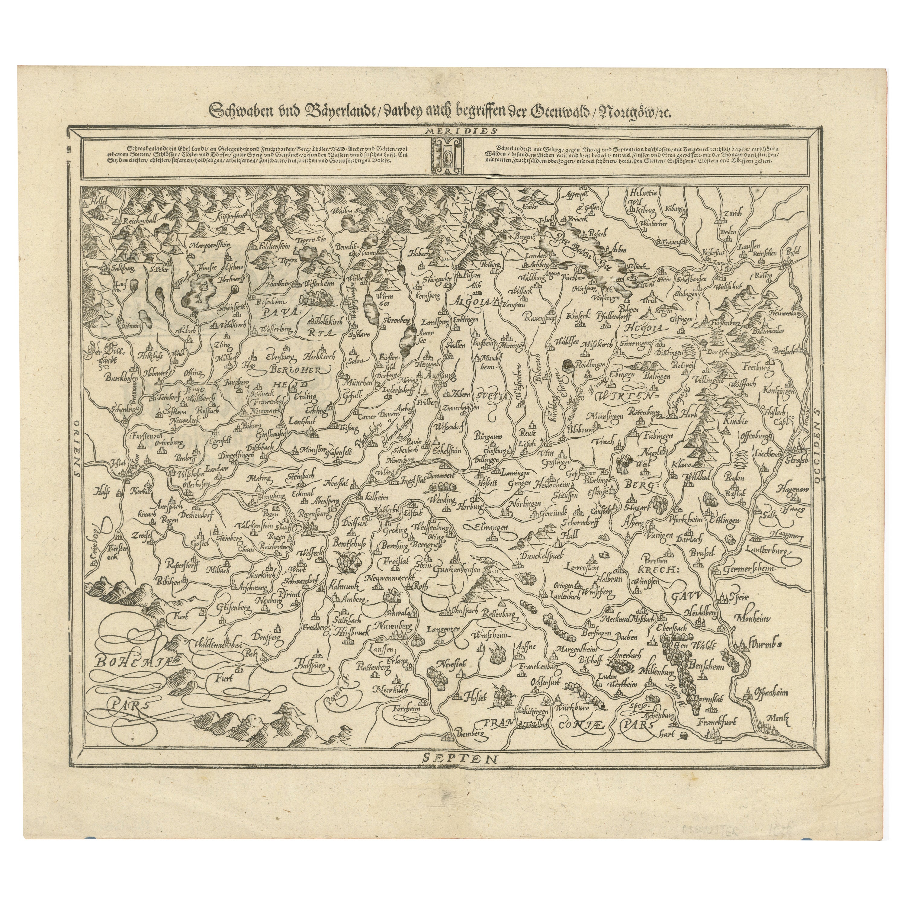
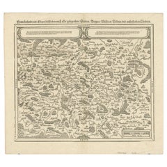
Early Woodcut Map of Swabia and Bavaria in Germany, 1628
Located in Langweer, NL
Title: Early Woodcut Map of Swabia and Bavaria, 16th Century
This early woodcut map titled "Schwaben und Bayernlande / Darbey auch begreiffen der Oenwaldt / Nordgaw / etc." provides...
Category
Antique 1620s Maps
Materials
Paper
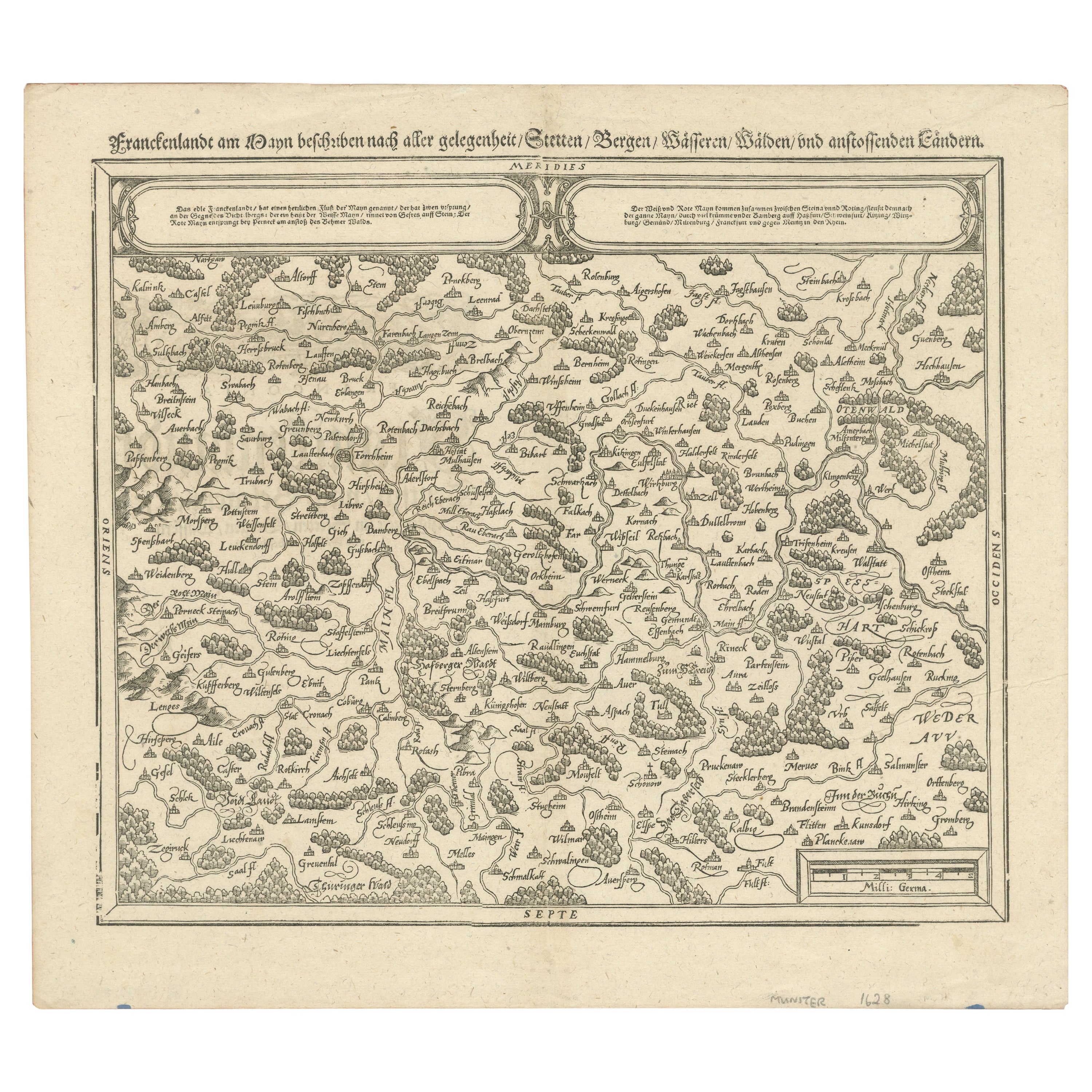
Early Woodcut Map of Franconia and Surrounding Regions, 1628
Located in Langweer, NL
Title: Early Woodcut Map of Franconia and Surrounding Regions, 1628
Franconia (Franckenlande) is a region in Germany. Historically, Franconia was a significant part of the Holy Roma...
Category
Antique 1620s Maps
Materials
Paper
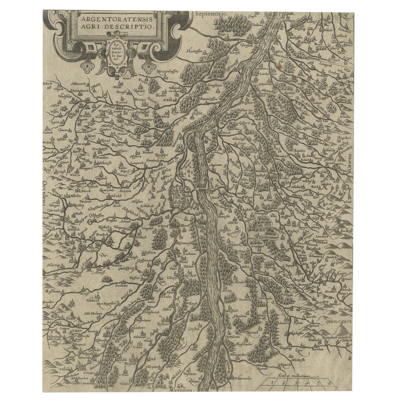
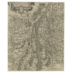
Original Antique Map of the Rhine, South and North of Strasbourg, Germany, 1608
Located in Langweer, NL
Antique map titled 'Argentoratensis agri descriptio'.
Original antique map of the Rhine, both south and north of Strasbourg, based on Daniel Specklin's three-sheet map of the Elz...
Category
Antique Early 1600s Maps
Materials
Paper
$307 Sale Price
20% Off
Antique Map of Germany of German in Roman Times, c.1660
Located in Langweer, NL
Antique map Germany titled 'Germaniae Veteris Typus'. Antique map probably by Blaeu or based on an earlier state by W. Blaeu.
Minor differences shown in the cartouches. Top left ha...
Category
Antique 17th Century Maps
Materials
Paper

Antique Map of Friesland
The Netherlands
by J. Bussemacher, 1596
By Johann Bussemacher
Located in Langweer, NL
Beautiful hand-colored engraving of the province Friesland (The Netherlands). This map originates from the Atlas 'Europae totius orbis terrarium partis praestantissimae, universalis ...
Category
Antique 16th Century European Maps
Materials
Paper
You May Also Like
Map of the Netherlands - Etching by G. Braun and F. Hogenberg -Late 16th Century
By Franz Hogenberg
Located in Roma, IT
Map of the Netherlands is an original etching realized by George Braun and Franz Hogenberg, as part of the "Civitates Orbis Terrarum".
The “Civitates Orbis Terrarum” (Atlas of Citi...
Category
16th Century Figurative Prints
Materials
Etching

17th Century Hand-Colored Map of a Region in West Germany by Janssonius
By Johannes Janssonius
Located in Alamo, CA
This attractive highly detailed 17th century original hand-colored map is entitled "Archiepiscopatus Maghdeburgensis et Anhaltinus Ducatus cum terris adjacentibus". It was published ...
Category
Antique Mid-17th Century Dutch Maps
Materials
Paper

$1,020 Sale Price
20% Off
1657 Janssonius Map of Vermandois and Cappelle, Ric. A-004
Located in Norton, MA
1657 Janssonius map of
Vermandois and Cappelle
Ric.a004
Description: Antique map of France titled 'Descriptio Veromanduorum - Gouvernement de la Cappelle'. Two detailed maps o...
Category
Antique 17th Century Unknown Maps
Materials
Paper

1592 Abraham Ortelius Map "Lorraine: Lotharingiae Nova Descripti, Ric.A005
Located in Norton, MA
1592 Abraham Ortelius map entitled
"Lorraine: Lotharingiae Nova Descripti
Ric.a005
Description: Ortelius is best known for producing the atlas from which this map comes from, "...
Category
Antique 16th Century Dutch Maps
Materials
Paper

1714 Henri Chatelain "Nouvelle Carte Des Etatas Du Grand.Duc De Mos Moscovie Eur
Located in Norton, MA
A 1714 Henri Chatelain map, entitled
"Nouvelle Carte Des Etatas Du Grand Duc De Moscovie En Europe,"
Ricb001
Henri Abraham Chatelain (1684-1743) was a Huguenot pastor of Parisi...
Category
Antique Early 18th Century Dutch Maps
Materials
Paper

17th Century Nicolas Visscher Map of Southeastern Europe
Located in Hamilton, Ontario
A beautiful, highly detailed map of southeastern Europe by Nicolas Visscher. Includes regions of Northern Italy (showing the cities Bologna, Padua, and Venice), Bohemia, Austria (sho...
Category
Antique 17th Century Dutch Maps
Materials
Paper

$1,350 Sale Price
38% Off
More Ways To Browse
Antique Tafel
18th Century Wood Side Tables
Antique Hand Carved Dining Room Sets
Mid Century Modern Pitcher
Vintage Italian Leather Dining Chair
Vintage Movie Posters
Blue Green Wool And Silk Rug
Brown Sheepskin Chair
Vintage Brass Bar Carts
Antique Botanical Prints
Green Persian Rug
17th Century Blue And White
50 X 50 Coffee Table
Antique Wood Panel Painted
Milo Baughman 1970
Spanish Baroque Furniture
Stone China
Couch Console