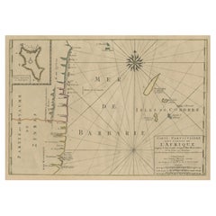
Items Similar to East African Coast – French Map by Bellin, Zanzibar to Arabia, 1740

Want more images or videos?
Request additional images or videos from the seller
1 of 9
East African Coast – French Map by Bellin, Zanzibar to Arabia, 1740
$528.47
£391.81
€440
CA$725.99
A$792.54
CHF 417.28
MX$9,493.72
NOK 5,336.89
SEK 4,872.67
DKK 3,352.64
About the Item
East African Coast – French Map by Bellin, Zanzibar to Arabia, 1740
This important French map depicts the eastern coast of Africa from Mozambique and Zanzibar northward to the Horn of Africa and the Arabian Peninsula. Titled “Carte de la Coste Orientale d’Afrique,” the map was engraved under the direction of Jacques-Nicolas Bellin, Hydrographer to the French King, and published in Paris in 1740 by order of the Comte de Maurepas.
The chart was drawn from Bellin’s larger map of the Indian Ocean and represents one of the earliest systematic French attempts to chart the East African coastline with consistency and comparative accuracy. It covers a vast geographic area, including Mozambique, Zanzibar, Mombasa, the Somali coast, the Red Sea entrance, southern Arabia, and the islands of Socotra and the Comoros, including Anjouan.
Bellin’s engraving emphasizes coastal continuity and navigational clarity. Key ports, capes, islands, and trading centers are carefully named, reflecting the importance of this coastline within Indian Ocean trade networks linking East Africa, Arabia, India, and Europe. Latitude lines, a longitudinal grid, and a finely engraved compass rose reinforce the map’s scientific and navigational intent.
The decorative cartouche, engraved in a restrained Rococo style, balances elegance with authority and identifies the map as an officially sanctioned French hydrographic production. Bellin’s work is known for its clarity and reliability, and his African coastal maps are increasingly sought after due to their historical significance and strong visual appeal.
This map offers a broad contextual view that complements more localized charts of Mozambique and the Comoros, making it particularly attractive to collectors interested in French colonial cartography, Indian Ocean trade history, or early European mapping of Africa.
Condition report
Good condition overall. Light age toning consistent with period. Minor scattered spots and a few small stains. Original hand coloring. Plate mark visible. Margins intact.
Framing tips
A warm ivory or light sand-colored mat works well with the aged paper tone and colored coastline. A medium to dark wood frame enhances the cartouche and compass rose without overpowering the composition. This map displays beautifully as a centerpiece or as part of a coordinated East African wall arrangement.
Technique: Copper engraving with contemporary hand color
Maker: Jacques-Nicolas Bellin, France, 1740
- Dimensions:Height: 10.36 in (26.3 cm)Width: 9.45 in (24 cm)Depth: 0.01 in (0.2 mm)
- Materials and Techniques:Paper,Engraved
- Place of Origin:
- Period:1740-1749
- Date of Manufacture:circa 1740
- Condition:Good condition overall. Light age toning consistent with period. Minor scattered spots and a few small stains. Original hand coloring. Plate mark visible. Margins intact.
- Seller Location:Langweer, NL
- Reference Number:Seller: BG-14128-31stDibs: LU3054348016712
About the Seller
5.0
Recognized Seller
These prestigious sellers are industry leaders and represent the highest echelon for item quality and design.
Platinum Seller
Premium sellers with a 4.7+ rating and 24-hour response times
Established in 2009
1stDibs seller since 2017
2,810 sales on 1stDibs
Typical response time: <1 hour
- ShippingRetrieving quote...Shipping from: Langweer, Netherlands
- Return Policy
More From This Seller
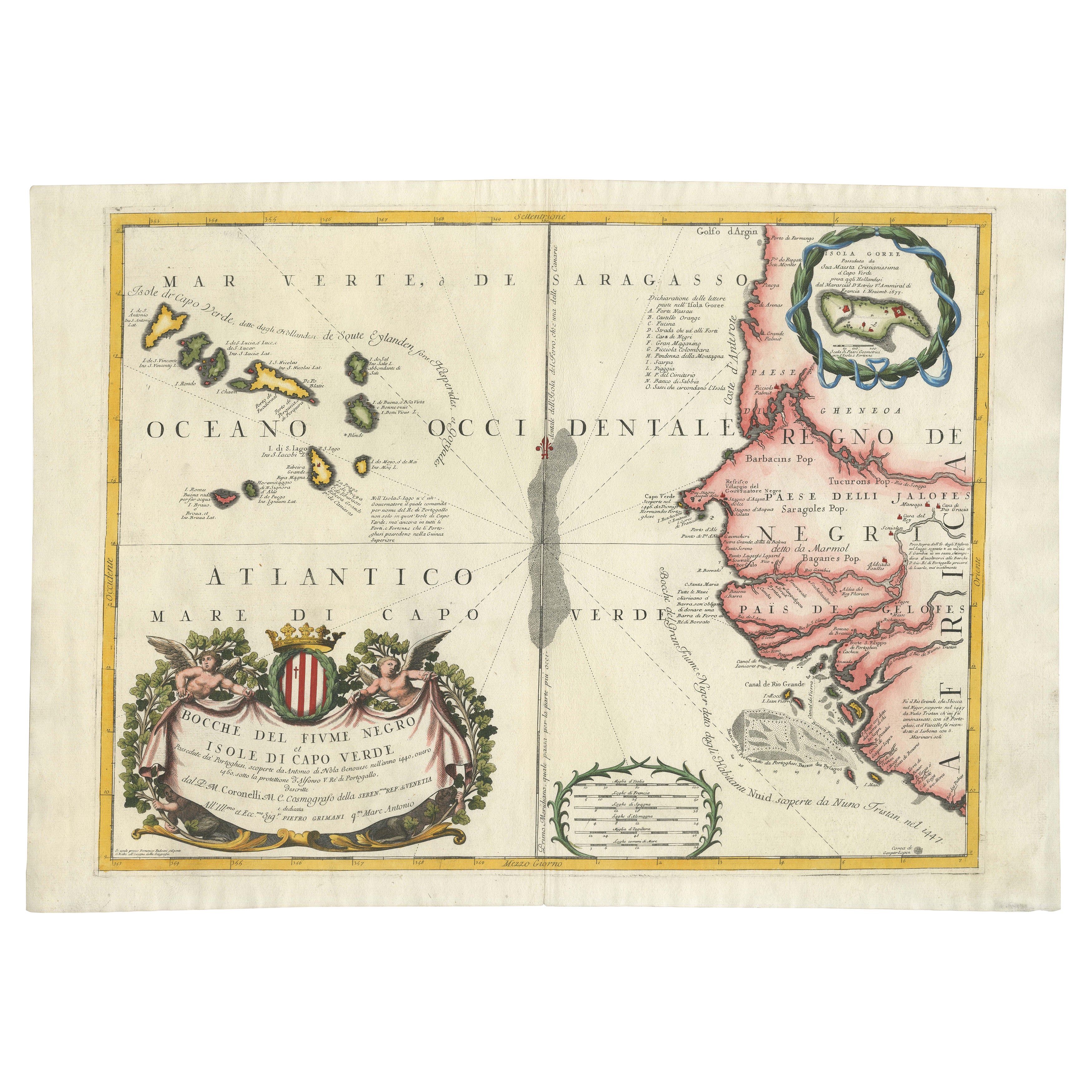
View AllMap of Cape Verde and the Mouth of the River Niger by Coronelli, 1691
Located in Langweer, NL
Map of Cape Verde and the Mouth of the River Niger by Coronelli, 1691
This finely engraved map, titled "Bocche del Fiume Negro et Isole di Capo Verde," was created in 1691 by Vincen...
Category
Antique Late 17th Century Maps
Materials
Paper
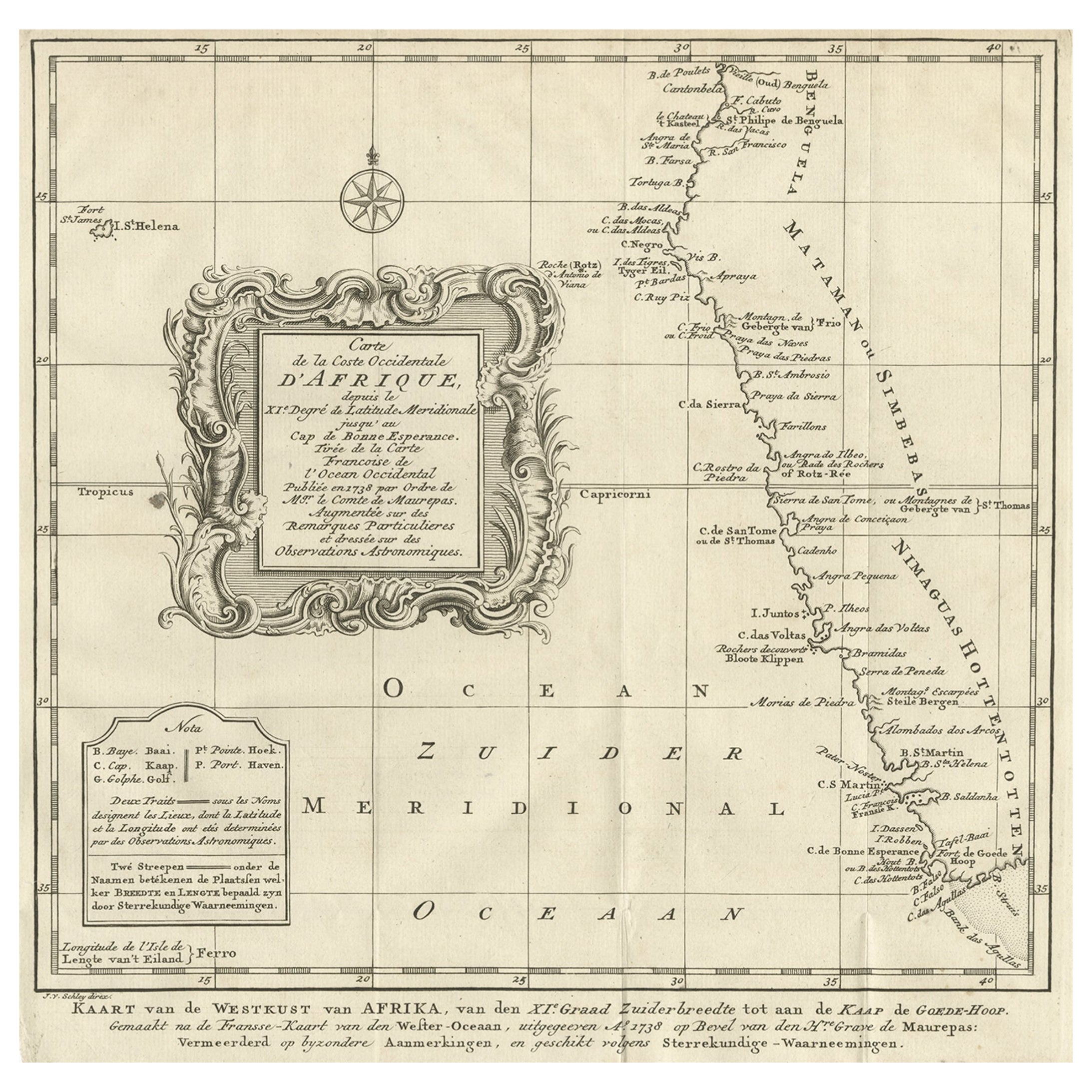
Dutch Antique Map of the West Coast of Africa, to the Cape of Good Hope, 1747
Located in Langweer, NL
Antique map of the Coast of Africa titled 'Kaart van de West Kust van Afrika (..)'.
Map of the west coast of Africa, from 11 degrees south latitude to the Cape of Good Hope. This...
Category
Antique 1740s Maps
Materials
Paper
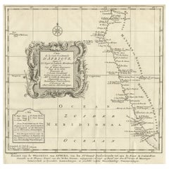
$374 Sale Price
20% Off
Free Shipping
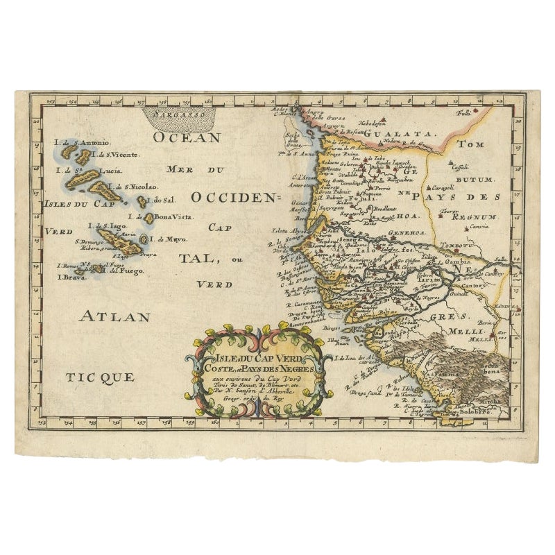
Antique Map of the West African Coast and the Cape Verde Islands, c.1680
Located in Langweer, NL
Antique map Africa titled 'Isles du Cap Verd Coste et Pays des Negres'. Antique map of the coast of Africa and the Cape Verde islands.
Artists and...
Category
Antique 17th Century Maps
Materials
Paper

$345 Sale Price
20% Off
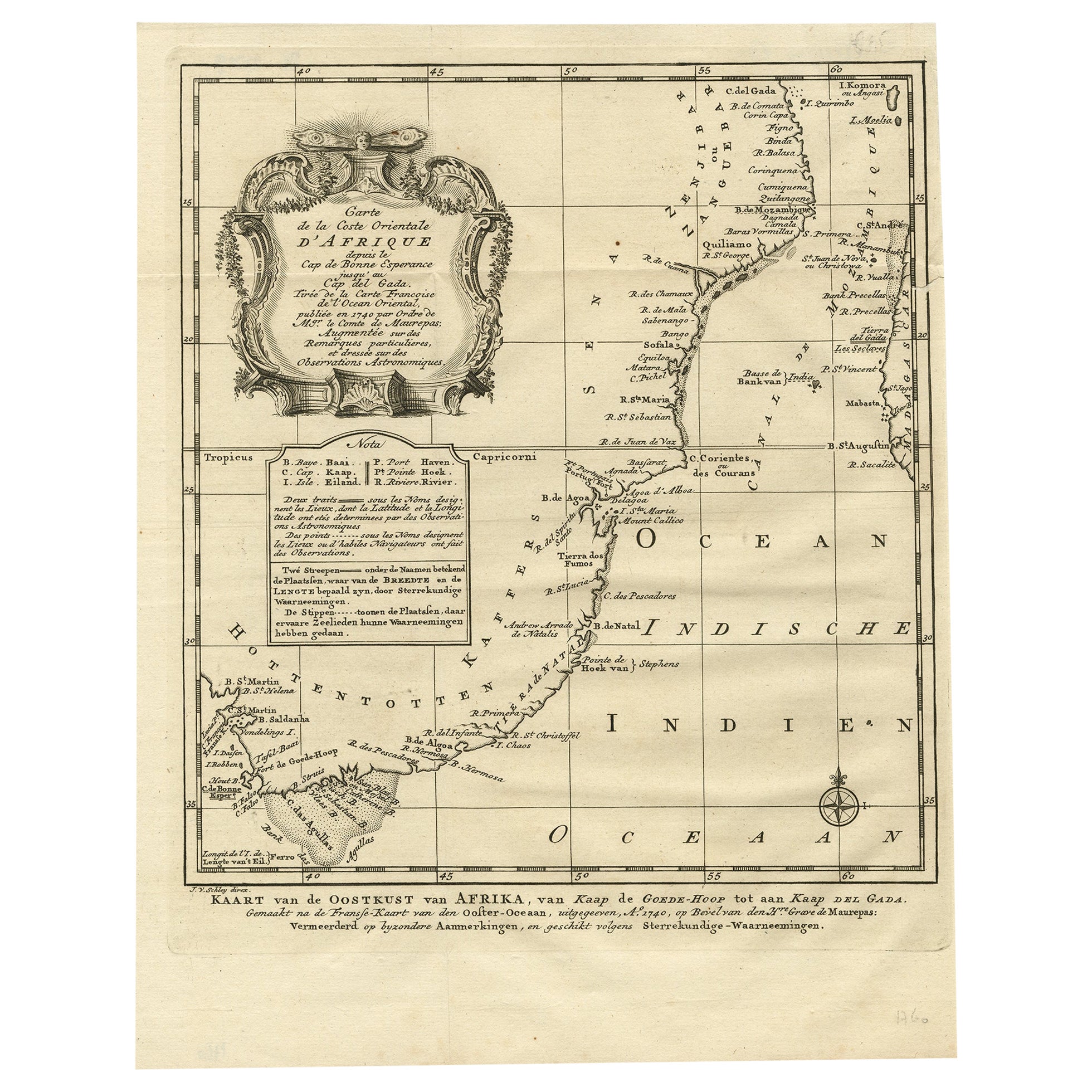
Original Detailed Antique Map of the East Coast of Africa, 1747
Located in Langweer, NL
Antique map titled 'Carte de la coste Orientale d'Afrique - Kaart van de Oostkust van Afrika'.
Original antique map of the east coast of Africa. Reaches from Cape of Good Hope an...
Category
Antique 1740s Maps
Materials
Paper

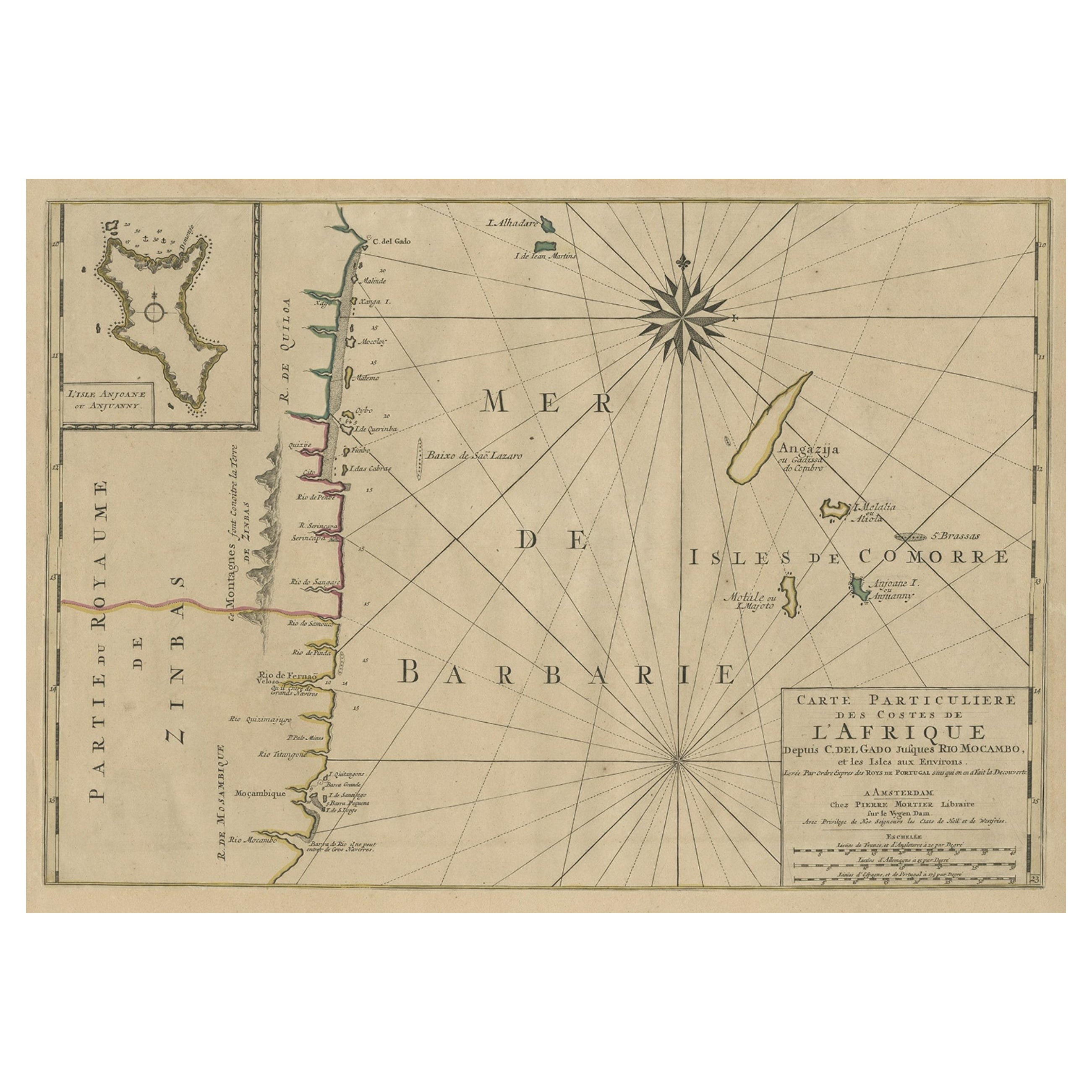
Map of the Mozambique and Tanzania Coast
Inset Map of Anjouan Island, ca.1700
Located in Langweer, NL
Antique map titled 'Carte particuliere des Costes de l'Afrique'.
Depicts the coasts of Mozambique and Tanzania. With an inset map of Anjouan Island.
Artists and engravers: Pub...
Category
Antique Early 1700s Maps
Materials
Paper
$614 Sale Price
20% Off
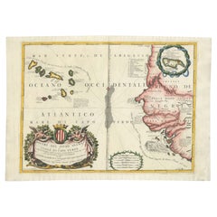
Antique Map of the Cape Verde Islands and Part of Senegal, West Africa, 1690
Located in Langweer, NL
Antique map titled 'Bocche del Fivme Negro et Isole di Capo Verde'. Beautiful double-page map of the Cape Verde Islands and part of the coast of Senegal, with large decorative cartou...
Category
Antique 17th Century Italian Maps
Materials
Paper

You May Also Like
West Coast of Africa, Guinea
Sierra Leone: An 18th Century Map by Bellin
By Jacques-Nicolas Bellin
Located in Alamo, CA
Jacques Bellin's copper-plate map entitled "Partie de la Coste de Guinee Dupuis la Riviere de Sierra Leona Jusquau Cap das Palmas", depicting the coast of Guinea and Sierra Leone in ...
Category
Antique Mid-18th Century French Maps
Materials
Paper

$460 Sale Price
20% Off
West Coast of Africa; Guinea
Sierra Leone: Bellin 18th Century Map
Located in Alamo, CA
This is a Jacques Bellin copper-plate map entitled "Partie de la Coste de Guinee Dupuis la Riviere de Sierra Leona Jusquau Cap das Palmas", depicting the coast of Guinea and Sierra L...
Category
1740s Old Masters Landscape Prints
Materials
Engraving

Africa: A Large 17th Century Hand-Colored Map by Sanson and Jaillot
By Nicolas Sanson
Located in Alamo, CA
This large original hand-colored copperplate engraved map of Africa entitled "L'Afrique divisee suivant l'estendue de ses principales parties ou sont distingues les uns des autres, L...
Category
Antique 1690s French Maps
Materials
Paper

$1,740 Sale Price
20% Off
Africa: A Large 17th Century Hand-colored Map By Sanson and Jaillot
By Nicholas Sanson d
Abbeville
Located in Alamo, CA
This large original hand-colored copperplate engraved map of Africa entitled "L'Afrique divisee suivant l'estendue de ses principales parties ou sont distingues les uns des autres, L...
Category
1690s Landscape Prints
Materials
Engraving

Antique Map - Mare Pacificum - Etching by Johannes Janssonius - 1650s
By Johannes Janssonius
Located in Roma, IT
Mare Pacificum is an antique map realized in 1650 by Johannes Janssonius (1588-1664).
The Map is Hand-colored etching, with coeval watercolorang.
Good conditions with slight foxing...
Category
1650s Modern Figurative Prints
Materials
Etching

"Africa Vetus": a 17th Century Hand-Colored Map by Sanson
By Nicolas Sanson
Located in Alamo, CA
This original hand-colored copperplate engraved map of Africa entitled "Africa Vetus, Nicolai Sanson Christianiss Galliar Regis Geographi" was originally created by Nicholas Sanson d...
Category
Antique Late 17th Century French Maps
Materials
Paper

$1,100 Sale Price
20% Off