Items Similar to Egypt
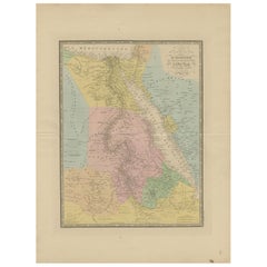
Lower Nubia – Elegant Antique Atlas Map of the Nile, ca.1888


Want more images or videos?
Request additional images or videos from the seller
1 of 9
Egypt
Lower Nubia – Elegant Antique Atlas Map of the Nile, ca.1888
$463.61
£345.06
€390
CA$642.98
A$692.23
CHF 370.70
MX$8,341.07
NOK 4,677.21
SEK 4,280.40
DKK 2,972.52
About the Item
Egypt
Lower Nubia – Elegant Antique Atlas Map of the Nile, ca.1888
This elegant antique atlas map presents Egypt and the Nile Valley in a refined, softly colored composition that feels timeless and architectural. The long vertical sweep of the Nile immediately draws the eye, flowing from the Mediterranean through Cairo and Upper Egypt toward Lower Nubia, framed by delicately engraved desert regions and subtle coastal shading along the Red Sea.
Produced by Rand, McNally
Co. at the height of late-19th-century American atlas design, the map combines clarity with a restrained pastel palette that works exceptionally well in contemporary interiors. The balance between open desert spaces and the finely detailed river corridor gives the sheet a calm, almost meditative presence on the wall, making it particularly attractive for living rooms, studies, libraries, or hospitality settings.
Cartographic details are crisp yet unobtrusive, allowing the overall composition to read as decorative rather than technical. The typography is elegant and evenly spaced, while the hand-colored regions add warmth without overpowering the design. When framed, the vertical format emphasizes the monumental scale of the Nile and creates a strong visual anchor in a room.
A particularly appealing feature of this sheet is that the reverse side displays a decorative map of Africa, making it a versatile double-sided atlas leaf. This adds interest for collectors and interior designers alike, whether framed with visible margins, floated in a double-glazed frame, or appreciated as a historical object in a portfolio or drawer.
Printed on original late-19th-century atlas paper, this map retains the authentic texture and presence expected of a period piece, offering both decorative impact and historical character without feeling heavy or academic.
Condition report: Original atlas paper with light age toning consistent with period. Minor edge wear and gentle handling marks typical of bound atlas sheets. Overall well preserved with clean color and strong legibility.
Framing tips: This map works beautifully in a light oak, walnut, or muted gold frame with an off-white or warm ivory mat. A tall vertical mat emphasizes the flow of the Nile and enhances the architectural feel. Museum glass is recommended to preserve the soft pastel tones.
Technique: Color lithograph
Maker: Rand, McNally
Co., United States, late 19th century
Keywords:
Egypt map, Nile map, Nile wall art, antique map of Egypt, decorative atlas map, Rand McNally map, antique Egypt wall art, Nile Valley map, African map reverse, antique atlas sheet, historic Egypt cartography, interior design wall map, library wall art, vintage Egypt map
- Dimensions:Height: 14.18 in (36 cm)Width: 10.44 in (26.5 cm)Depth: 0.01 in (0.2 mm)
- Materials and Techniques:Paper,Engraved
- Place of Origin:
- Period:
- Date of Manufacture:1888
- Condition:Original atlas paper with light age toning consistent with period. Minor edge wear and gentle handling marks typical of bound atlas sheets. Overall well preserved with clean color and strong legibility.
- Seller Location:Langweer, NL
- Reference Number:Seller: BG-12794-691stDibs: LU3054348221322
About the Seller
5.0
Recognized Seller
These prestigious sellers are industry leaders and represent the highest echelon for item quality and design.
Platinum Seller
Premium sellers with a 4.7+ rating and 24-hour response times
Established in 2009
1stDibs seller since 2017
2,828 sales on 1stDibs
Typical response time: 1 hour
- ShippingRetrieving quote...Shipping from: Langweer, Netherlands
- Return Policy
More From This Seller
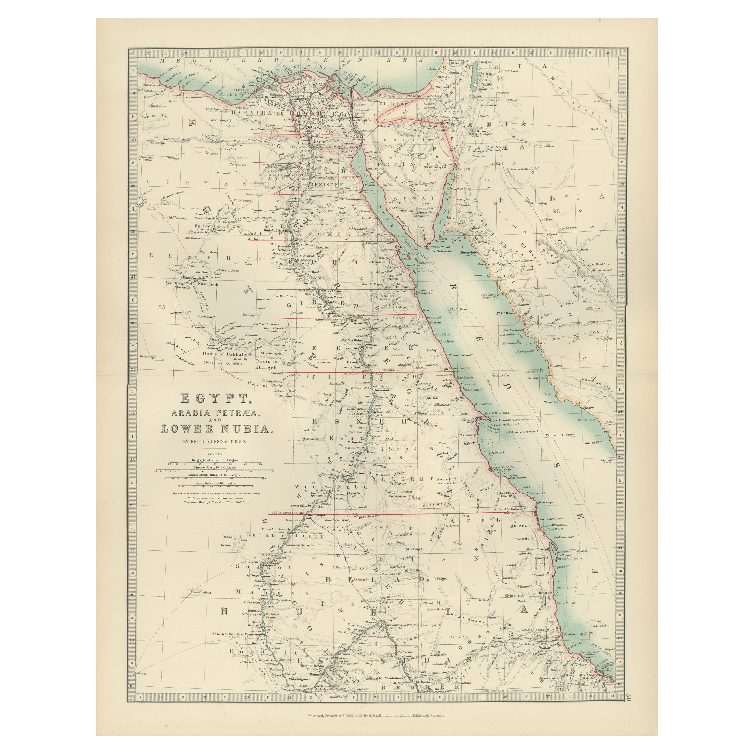
View AllEgypt and Lower Nubia, 1903 - Historical Map Highlighting Nile and Red Sea
Located in Langweer, NL
Egypt and Lower Nubia, 1903 - Historical Map Highlighting Nile and Red Sea
This beautifully detailed map titled "Egypt, Arabia Petraea, and Lower Nubia" was engraved, printed, and p...
Category
Early 20th Century Maps
Materials
Paper
Egypt
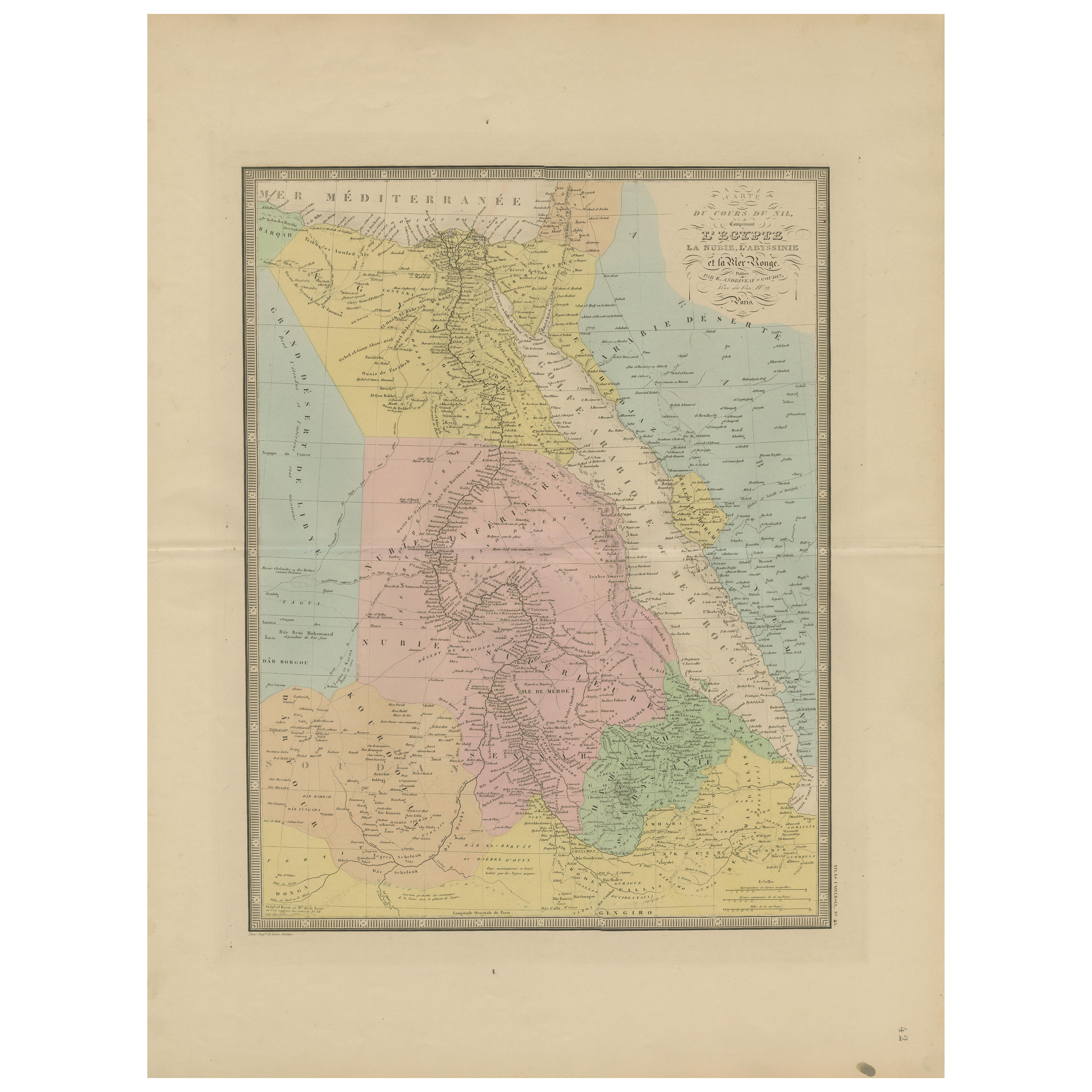
Red Sea Antique Map – Detailed 1865 Chart of Nubia and Nile Regions
Located in Langweer, NL
Antique Map of Egypt, Nubia & Red Sea Coast – Andriveau-Goujon, Paris 1865
This delicately colored antique map, titled *Partie du Cours du Nil comprenant l'Égypte, la Nubie, l'Abyss...
Category
Antique Mid-19th Century French Maps
Materials
Paper
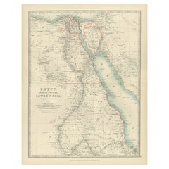
Antique Map of Egypt, Arabia Petraea and Lower Nubia by Johnston
1909
Located in Langweer, NL
Antique map titled 'Egypt, Arabia Petraea and Lower Nubia'. Original antique map of Egypt, Arabia Petraea and Lower Nubia. With inset maps of Alexandriam Cairo and the Suez Canal...
Category
Early 20th Century Maps
Materials
Paper

$223 Sale Price
24% Off
Antique Map of Egypt and Arabia Petraea by A
C. Black, 1870
Located in Langweer, NL
Antique map titled 'Egypt and Arabia Petraea'. Original antique map of Egypt and Arabia Petraea. This map originates from ‘Black's General Atlas of The World’. Published by A & C. Bl...
Category
Antique Late 19th Century Maps
Materials
Paper

$145 Sale Price
30% Off
Egypt
Arabia Petraea – Large Nile Map, British Cartography, c.1815
Located in Langweer, NL
Egypt & Arabia Petraea – Large Nile Map, British Cartography, c.1815
This impressive early 19th-century map depicts Egypt and Arabia Petraea with exceptional detail, extending from ...
Category
Antique 1810s British Maps
Materials
Paper

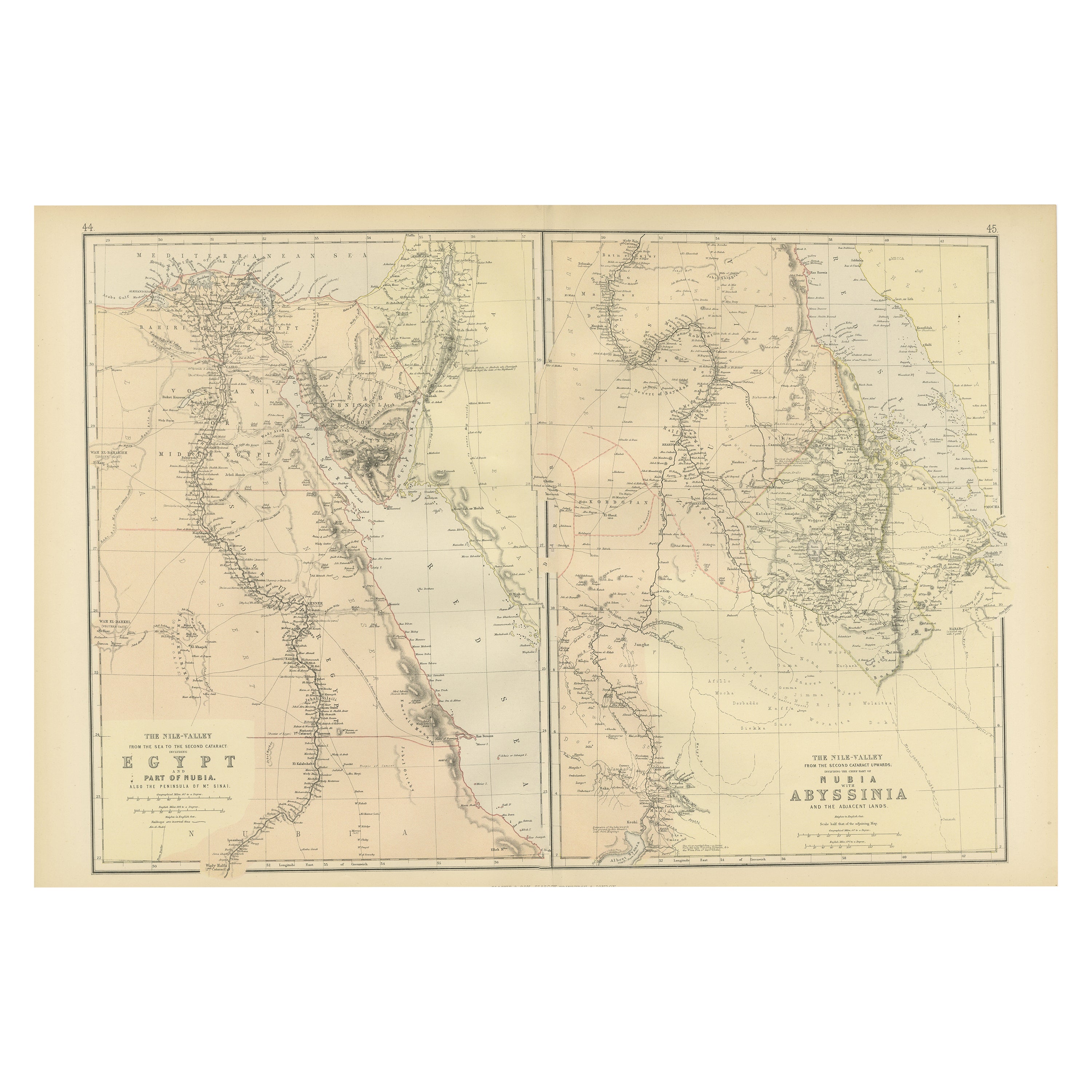
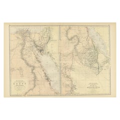
Antique Decorative Coloured Map Egypt, Nubia, Abyssinia and more, 1882
Located in Langweer, NL
This image contains two maps, with the left one being labeled "Egypt" and the right one "Nubia, Abyssinia and the Adjacent Lands." These maps highlight the Nile Valley and surrounding regions.
The maps from the Blackie & Son atlas published in 1882 are interesting for several reasons:
1. **Historical Context**: The year 1882 is significant because it falls within the period of European imperial expansion in Africa. It was also just before the British occupation of Egypt, which began that year. Therefore, the maps serve as historical documents showing the geopolitical state of the region just before a major shift in its colonial status.
2. **Cartographic Style**: The maps reflect the cartographic style of the late 19th century, which often featured detailed engravings and fine detail. They provide a snapshot of the cartographic knowledge and aesthetic of the time.
3. **Geographical Knowledge**: These maps were created during a time when much of Africa's interior was still being explored by Europeans. The representation of features like rivers, mountains, and settlements can tell us about the extent of geographical knowledge at the time.
4. **Cultural Representation**: The way the map represents different regions, peoples, and geographical features can give insights into the cultural and political views of the era. It may reflect the European understanding and biases towards these regions.
5. **Educational Purpose**: Blackie & Son were known for their educational materials...
Category
Antique 1880s Maps
Materials
Paper
You May Also Like
Africa. North-East Part. Century Atlas antique vintage map
Located in Melbourne, Victoria
'The Century Atlas. Africa. North-East Part'
Original antique map, 1903.
Inset map of 'Nile Delta and Suez Canal'.
Central fold as issued. Map name and nu...
Category
Early 20th Century Victorian More Prints
Materials
Lithograph

Africa. North-West Part. Century Atlas antique vintage map
Located in Melbourne, Victoria
'The Century Atlas. Africa. Southern Part'
Original antique map, 1903.
Central fold as issued. Map name and number printed on the reverse corners.
Sheet 40cm by 29.5cm.
Category
Early 20th Century Victorian More Prints
Materials
Lithograph

Africa. Central. Century Atlas antique vintage map
Located in Melbourne, Victoria
'The Century Atlas. Africa. Central'
Inset map of 'Madagascar'.
Original antique map, 1903.
Central fold as issued. Map name and number printed on the reverse corners.
Sheet 29.5cm...
Category
Early 20th Century Victorian More Prints
Materials
Lithograph

Original Antique Map of Africa by Dower, circa 1835
Located in St Annes, Lancashire
Nice map of Africa
Drawn and engraved by J.Dower
Published by Orr & Smith. C.1835
Unframed.
Free shipping
Category
Antique 1830s English Maps
Materials
Paper

Large Original Vintage Map of Egypt, circa 1920
Located in St Annes, Lancashire
Great map of Egypt
Unframed
Original color
By John Bartholomew and Co. Edinburgh Geographical Institute
Published, circa 1920
Free shipping.
Category
Vintage 1920s British Maps
Materials
Paper

Large Original Antique Map of Morocco. Edward Weller, 1861
Located in St Annes, Lancashire
Great map of Morocco
Lithograph engraving by Edward Weller
Original colour
Published, 1861
Unframed
Good condition.
Category
Antique 1860s English Victorian Maps
Materials
Paper
