Items Similar to Egypt
Red Sea Antique Map – Detailed 1865 Chart of Nubia and Nile Regions


Want more images or videos?
Request additional images or videos from the seller
1 of 10
Egypt
Red Sea Antique Map – Detailed 1865 Chart of Nubia and Nile Regions
$466.46
£346.38
€390
CA$640.85
A$696.73
CHF 369.41
MX$8,352.07
NOK 4,695
SEK 4,301.26
DKK 2,973.05
About the Item
Antique Map of Egypt, Nubia
Red Sea Coast – Andriveau-Goujon, Paris 1865
This delicately colored antique map, titled *Partie du Cours du Nil comprenant l'Égypte, la Nubie, l'Abyssinie et la Mer Rouge*, was engraved and published in Paris in 1865 by E. Andriveau-Goujon. It was issued as part of the Atlas Universel, a monumental cartographic work known for its clarity, precision, and fine aesthetic detailing.
The map focuses on the northeastern quadrant of Africa, tracing the course of the Nile River from its mouth in the Mediterranean through Egypt and Nubia, deep into the then-mysterious central interior of Africa. Major cities such as Cairo, Thebes (Luxor), Dongola, Khartoum, and Gondar are labeled, as well as regions such as Nubie (Nubia), Sennar, Darfour, Kordofan, and Abyssinie (Ethiopia).
Geographical features like the White Nile and Blue Nile are distinguished, and significant emphasis is placed on the mountainous and desert terrain flanking the Nile basin. The Red Sea coast is depicted in detail, showing ports, settlements, and inland connections important for trade and pilgrimage routes.
What makes this map particularly significant is its capture of African geography during a period of growing European interest in exploration and colonization. At the time, much of central Africa remained only partially mapped, and Andriveau-Goujon’s attempt to represent key ethnographic, political, and hydrological elements reflects both contemporary knowledge and speculative geography.
To collectors and historians, this is an important visual document of 19th-century African cartography, representing colonial, scientific, and navigational ambitions of the era.
Condition: Very good. Sharp plate impression, with attractive original hand coloring. Slight age toning at the margins, original centerfold visible. No tears or repairs.
Framing tips: Best suited to a gold or walnut wooden frame with a soft cream or light beige mat to match the antique paper tone and highlight the vivid color borders.
Technique: Engraving with original hand coloring
Maker: E. Andriveau-Goujon, Paris, 1865
- Dimensions:Height: 27.64 in (70.2 cm)Width: 20.91 in (53.1 cm)Depth: 0.01 in (0.2 mm)
- Materials and Techniques:Paper,Engraved
- Place of Origin:
- Period:
- Date of Manufacture:1865
- Condition:Condition: Very good. Sharp plate impression, with attractive original hand coloring. Slight age toning at the margins, original centerfold visible. No tears or repairs.
- Seller Location:Langweer, NL
- Reference Number:Seller: BG-14099-171stDibs: LU3054346186262
About the Seller
5.0
Recognized Seller
These prestigious sellers are industry leaders and represent the highest echelon for item quality and design.
Platinum Seller
Premium sellers with a 4.7+ rating and 24-hour response times
Established in 2009
1stDibs seller since 2017
2,821 sales on 1stDibs
Typical response time: 1 hour
- ShippingRetrieving quote...Shipping from: Langweer, Netherlands
- Return Policy
More From This Seller
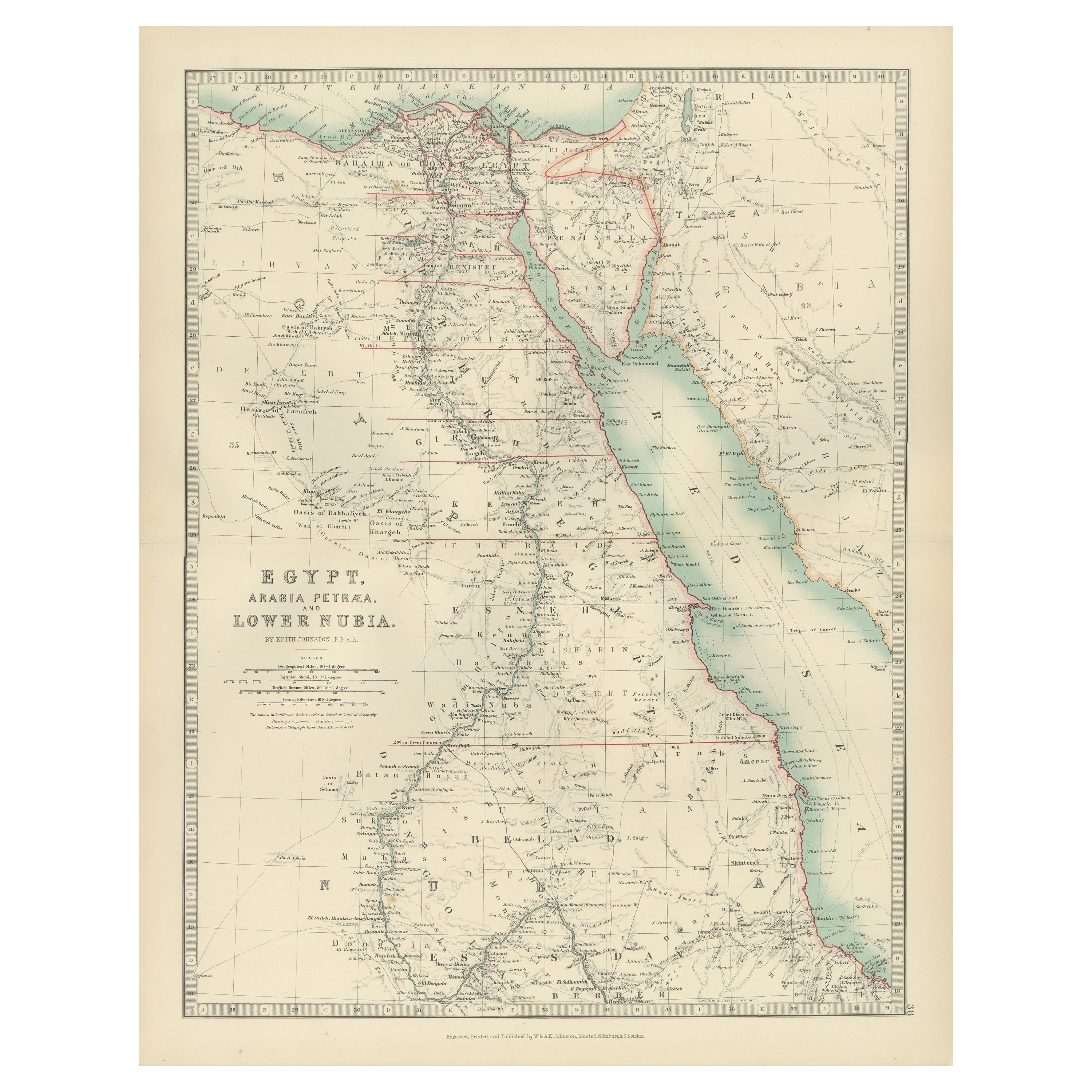
View AllEgypt and Lower Nubia, 1903 - Historical Map Highlighting Nile and Red Sea
Located in Langweer, NL
Egypt and Lower Nubia, 1903 - Historical Map Highlighting Nile and Red Sea
This beautifully detailed map titled "Egypt, Arabia Petraea, and Lower Nubia" was engraved, printed, and p...
Category
Early 20th Century Maps
Materials
Paper
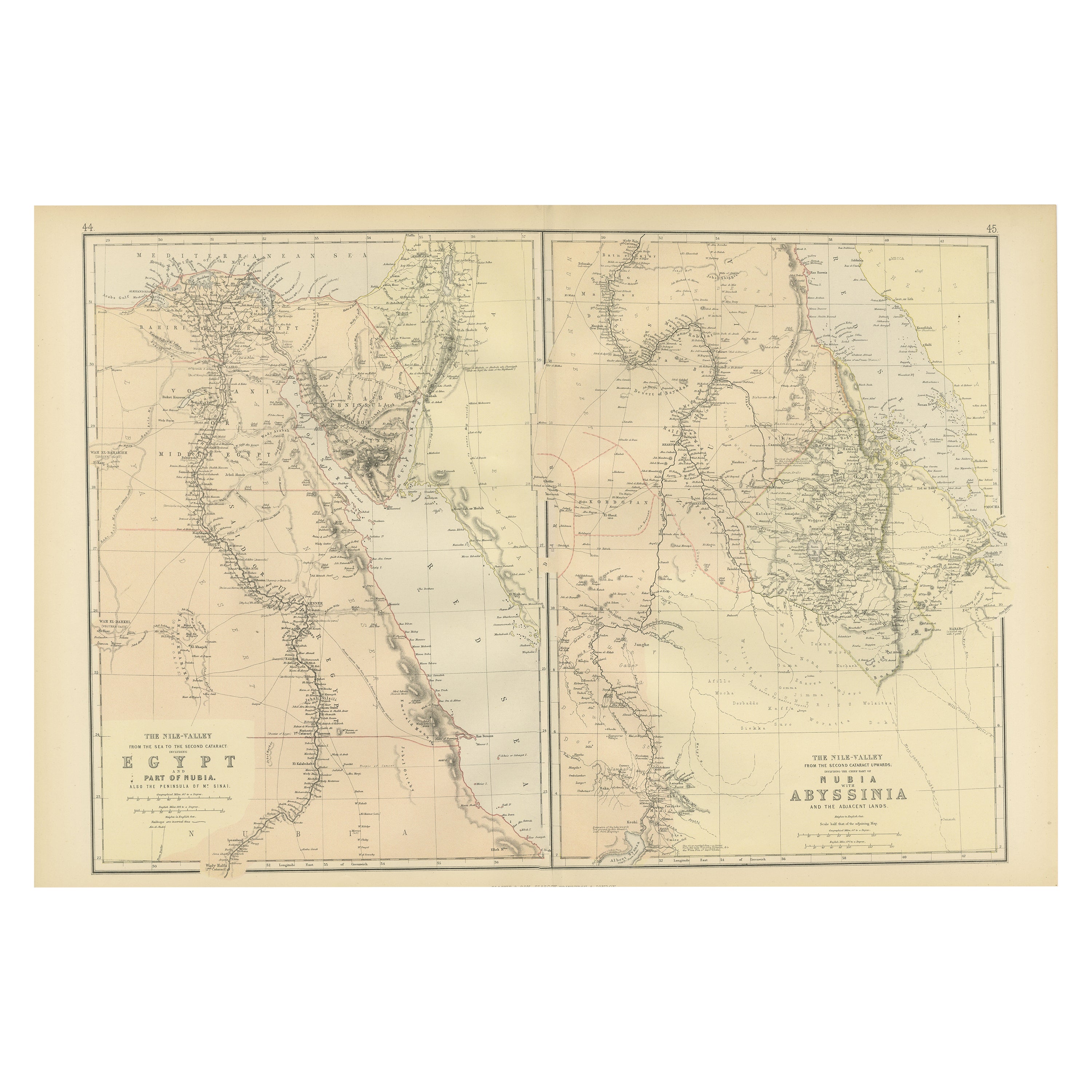
Antique Decorative Coloured Map Egypt, Nubia, Abyssinia and more, 1882
Located in Langweer, NL
This image contains two maps, with the left one being labeled "Egypt" and the right one "Nubia, Abyssinia and the Adjacent Lands." These maps highlight the Nile Valley and surrounding regions.
The maps from the Blackie & Son atlas published in 1882 are interesting for several reasons:
1. **Historical Context**: The year 1882 is significant because it falls within the period of European imperial expansion in Africa. It was also just before the British occupation of Egypt, which began that year. Therefore, the maps serve as historical documents showing the geopolitical state of the region just before a major shift in its colonial status.
2. **Cartographic Style**: The maps reflect the cartographic style of the late 19th century, which often featured detailed engravings and fine detail. They provide a snapshot of the cartographic knowledge and aesthetic of the time.
3. **Geographical Knowledge**: These maps were created during a time when much of Africa's interior was still being explored by Europeans. The representation of features like rivers, mountains, and settlements can tell us about the extent of geographical knowledge at the time.
4. **Cultural Representation**: The way the map represents different regions, peoples, and geographical features can give insights into the cultural and political views of the era. It may reflect the European understanding and biases towards these regions.
5. **Educational Purpose**: Blackie & Son were known for their educational materials...
Category
Antique 1880s Maps
Materials
Paper
Large Antique Map of the Lower Nile Valley Including Egypt and Nubia, 1842
Located in Langweer, NL
Antique map titled 'Carte de l'Égypte, de la Nubie, de l'Abissinie'. Map of Egypt, covering the lower Nile valley including Egypt and Nubia. This map o...
Category
Antique 19th Century French Maps
Materials
Paper

$430 Sale Price
20% Off
Antique Map of Egypt and Arabia Petraea by A
C. Black, 1870
Located in Langweer, NL
Antique map titled 'Egypt and Arabia Petraea'. Original antique map of Egypt and Arabia Petraea. This map originates from ‘Black's General Atlas of The World’. Published by A & C. Bl...
Category
Antique Late 19th Century Maps
Materials
Paper

$145 Sale Price
30% Off
Antique Map of Egypt, Arabia Petraea and Lower Nubia by Johnston
1909
Located in Langweer, NL
Antique map titled 'Egypt, Arabia Petraea and Lower Nubia'. Original antique map of Egypt, Arabia Petraea and Lower Nubia. With inset maps of Alexandriam Cairo and the Suez Canal...
Category
Early 20th Century Maps
Materials
Paper

$224 Sale Price
24% Off
Antique Map of Ancient Egypt Also Depicting the Nile River and Red Sea, 1845
Located in Langweer, NL
Antique map Egypt titled 'General Karte von Alt Aegypten von A.H. Brué'. Large map of Egypt also depicting the Nile river and Red Sea. Source unknown...
Category
Antique 19th Century Maps
Materials
Paper

You May Also Like
Africa. North-East Part. Century Atlas antique vintage map
Located in Melbourne, Victoria
'The Century Atlas. Africa. North-East Part'
Original antique map, 1903.
Inset map of 'Nile Delta and Suez Canal'.
Central fold as issued. Map name and nu...
Category
Early 20th Century Victorian More Prints
Materials
Lithograph

Africa. North-West Part. Century Atlas antique vintage map
Located in Melbourne, Victoria
'The Century Atlas. Africa. Southern Part'
Original antique map, 1903.
Central fold as issued. Map name and number printed on the reverse corners.
Sheet 40cm by 29.5cm.
Category
Early 20th Century Victorian More Prints
Materials
Lithograph

Africa. Central. Century Atlas antique vintage map
Located in Melbourne, Victoria
'The Century Atlas. Africa. Central'
Inset map of 'Madagascar'.
Original antique map, 1903.
Central fold as issued. Map name and number printed on the reverse corners.
Sheet 29.5cm...
Category
Early 20th Century Victorian More Prints
Materials
Lithograph

Large Original Antique Map of Morocco. Edward Weller, 1861
Located in St Annes, Lancashire
Great map of Morocco
Lithograph engraving by Edward Weller
Original colour
Published, 1861
Unframed
Good condition.
Category
Antique 1860s English Victorian Maps
Materials
Paper

Large Original Antique Map of Afghanistan. Edward Weller, 1861
Located in St Annes, Lancashire
Great map of Afghanistan
Lithograph engraving by Edward Weller
Original colour
Published, 1861
Unframed
Good condition
Category
Antique 1860s English Victorian Maps
Materials
Paper

Large Original Vintage Map of Egypt, circa 1920
Located in St Annes, Lancashire
Great map of Egypt
Unframed
Original color
By John Bartholomew and Co. Edinburgh Geographical Institute
Published, circa 1920
Free shipping.
Category
Vintage 1920s British Maps
Materials
Paper

More Ways To Browse
Africa Colonial
Pair Of Danish Chairs
Veneer Dining Tables
1970 Italian Armchair
Furniture Uk
House Of Denmark Table And Chairs
Louis Marble Top Side Table
Antique Russian Rugs
Baker Furniture By
For Kids
Sterling Silver Flatware Set Service For 12
Tufted Bar
Pair Of French Antique Armchairs
1970s Brass Glass Coffee Table
Antique Column Base
Charles Rennie Mackintosh For Cassina
Glass Salt
Italian Modern Silver Vases