Items Similar to Engraved Map of Northern England, Focusing on Northumberland, 1658


Want more images or videos?
Request additional images or videos from the seller
1 of 5
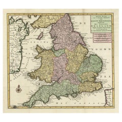
Engraved Map of Northern England, Focusing on Northumberland, 1658
$419.37
$524.2120% Off
£311.56
£389.4520% Off
€352
€44020% Off
CA$581.48
CA$726.8420% Off
A$625.33
A$781.6620% Off
CHF 334.36
CHF 417.9620% Off
MX$7,541.28
MX$9,426.6020% Off
NOK 4,228.26
NOK 5,285.3320% Off
SEK 3,852.49
SEK 4,815.6220% Off
DKK 2,682.82
DKK 3,353.5320% Off
About the Item
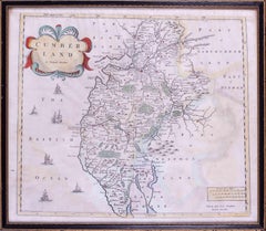
Antique map titled 'Ancien Royaume de Northumberland, aujourdhuy Provinces de Nort (..)'.
Engraved map of northern England, focusing on Northumberland.
Artists and Engravers: Nicholas Sanson (1600-1667) is considered the father of French cartography in its golden age from the mid-seventeenth century to the mid-eighteenth. Over the course of his career he produced over 300 maps. His success can be chalked up to his geographic and research skills, but also to his partnership with Pierre Mariette.
- Dimensions:Height: 16.54 in (42 cm)Width: 23.04 in (58.5 cm)Depth: 0 in (0.02 mm)
- Materials and Techniques:
- Period:1650-1659
- Date of Manufacture:1658
- Condition:Wear consistent with age and use. Condition: Good, original/contemporary hand coloring. General age-related toning, minor wear. Blank verso, please study image carefully.
- Seller Location:Langweer, NL
- Reference Number:Seller: BG-12426-2 1stDibs: LU3054327097042
About the Seller
5.0
Recognized Seller
These prestigious sellers are industry leaders and represent the highest echelon for item quality and design.
Platinum Seller
Premium sellers with a 4.7+ rating and 24-hour response times
Established in 2009
1stDibs seller since 2017
2,826 sales on 1stDibs
Typical response time: 1 hour
- ShippingRetrieving quote...Shipping from: Langweer, Netherlands
- Return Policy
More From This Seller
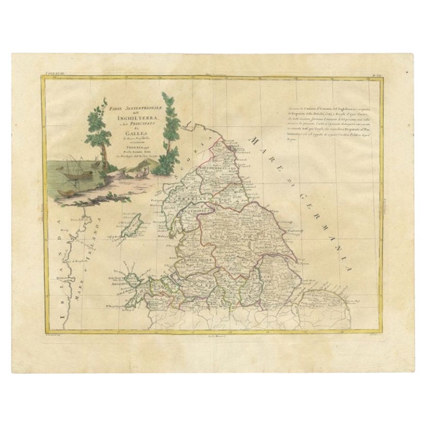
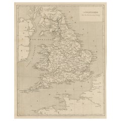
View AllAntique Map of Northern England and Wales by Zatta, 1784
Located in Langweer, NL
Antique map titled 'Parte Settentrionale dell' Inghilterra e del Principato di Galles'. Engraved map of the northern part of England and Wales, with title cartouche. Shows political and administrative divisions, towns, villages, forests, mountains and rivers. This print originates from 'Atlante Novissimo, illustrato ed accresciuto sulle osservazioni, e scoperte fatte dai piu' celebri e piu' recenti geografi' by A. Zatta. Artists and Engravers: Antonio Zatta (active 1757-1797) was the most prominent Italian map...
Category
Antique 18th Century Maps
Materials
Paper

$203 Sale Price
20% Off
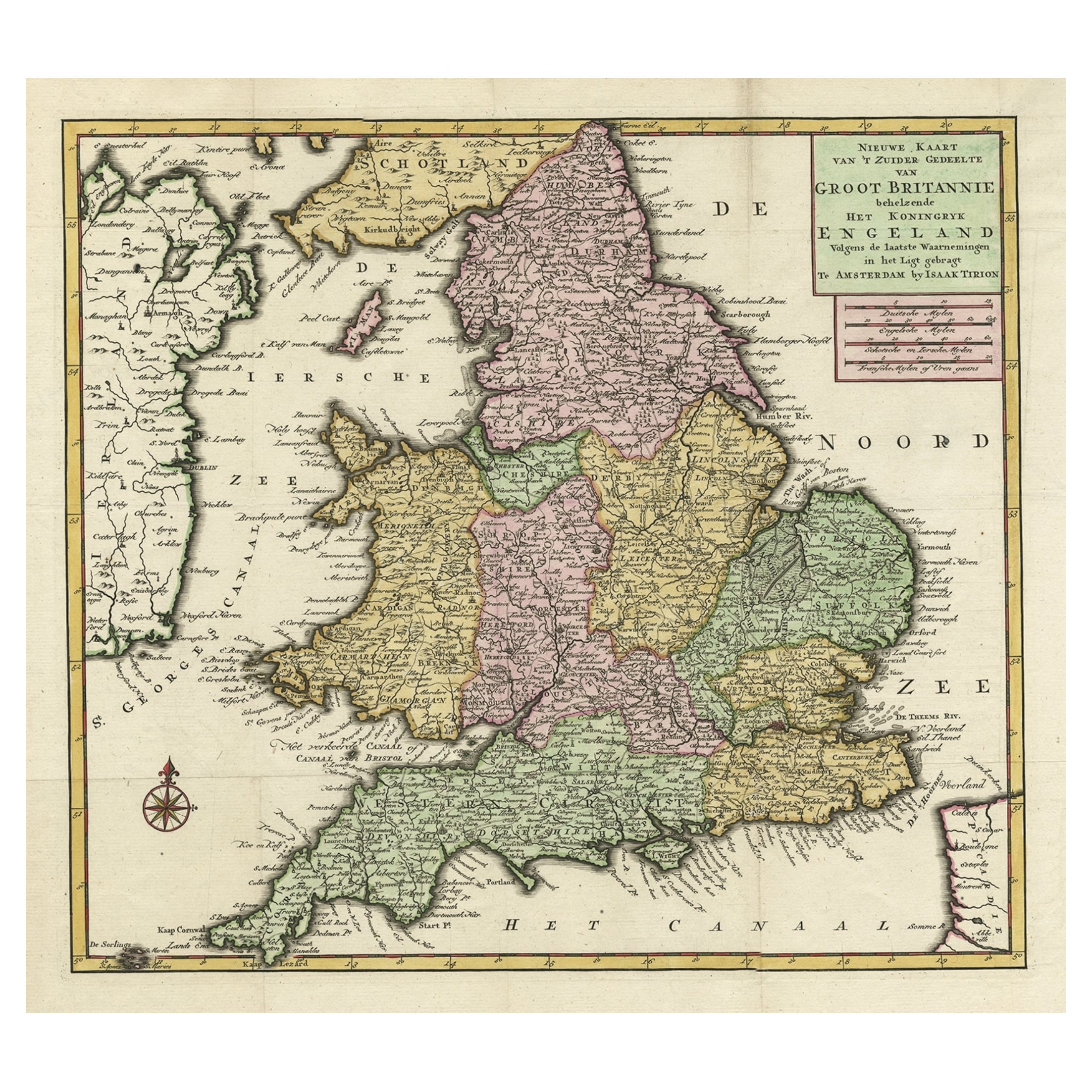
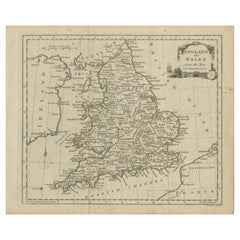
Antique Map of the South Part of Great Britain by Tirion, c.1750
By Isaak Tirion
Located in Langweer, NL
Antique map titled 'Nieuwe Kaart van 'T Zuider Gedeelte van Groot Britannie behelzende Het Koningryk Engeland (..).'
Attractive map showing the south part of Great Britain; the K...
Category
Antique 18th Century Maps
Materials
Paper
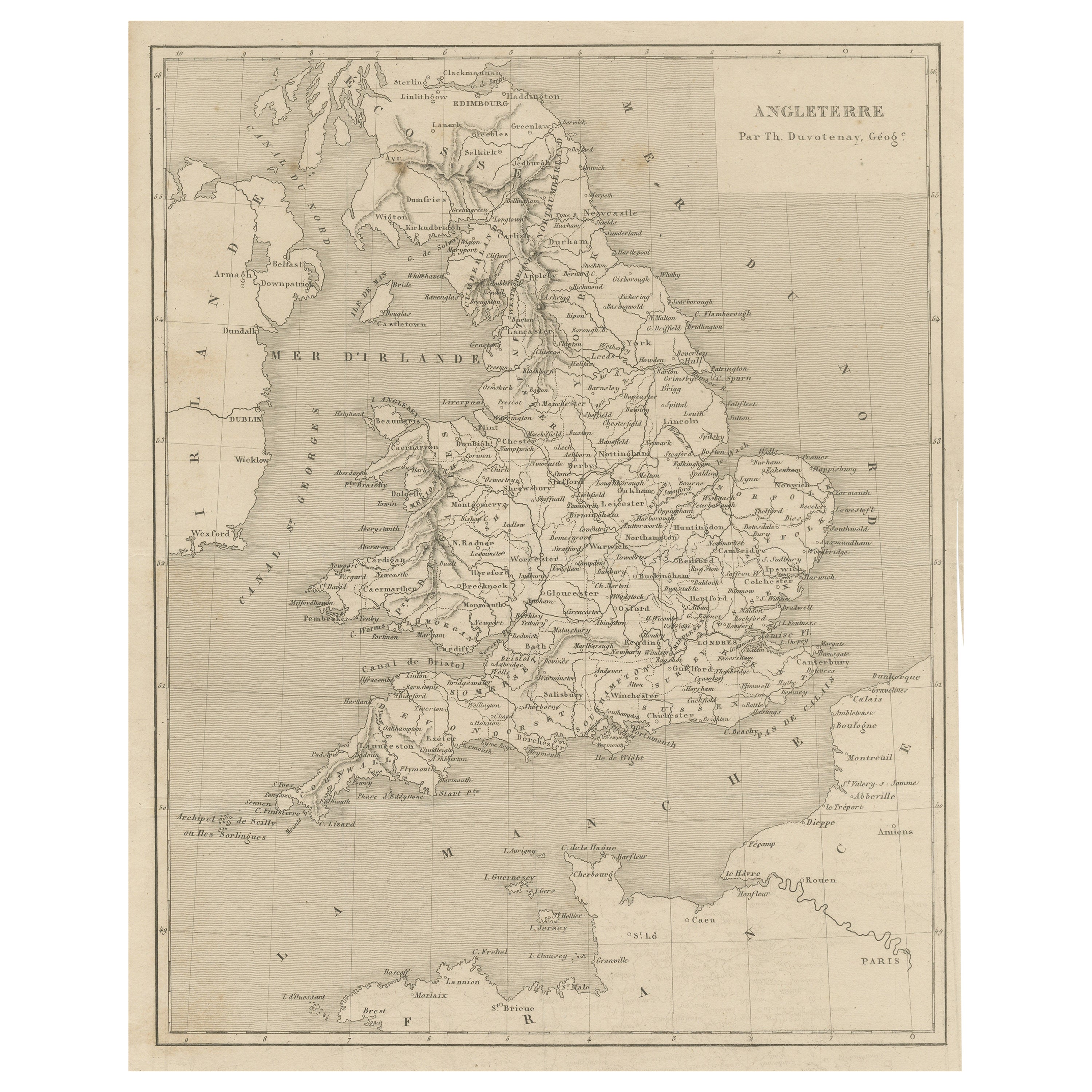
Steel Engraved Antique Map of England
Located in Langweer, NL
Antique map titled 'Angleterre'. Original antique map of England. Engraved by Th. Duvotenay. Originates from 'Complement de L'Encyclopedie Mode...
Category
Antique Late 19th Century Maps
Materials
Paper
$133 Sale Price
20% Off
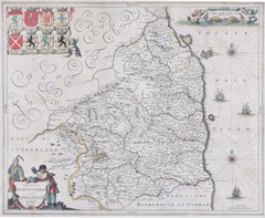
Antique Map of the Northeast of England by Mercator
circa 1620
Located in Langweer, NL
Antique map titled 'Eboracum Lincolnia, Derbia, Staffordia, Notinghamia, Lecestria, Rutlandia, et Norfolcia'. Decorative early map of the northeast of England, comprising the countie...
Category
Antique Early 17th Century Maps
Materials
Paper

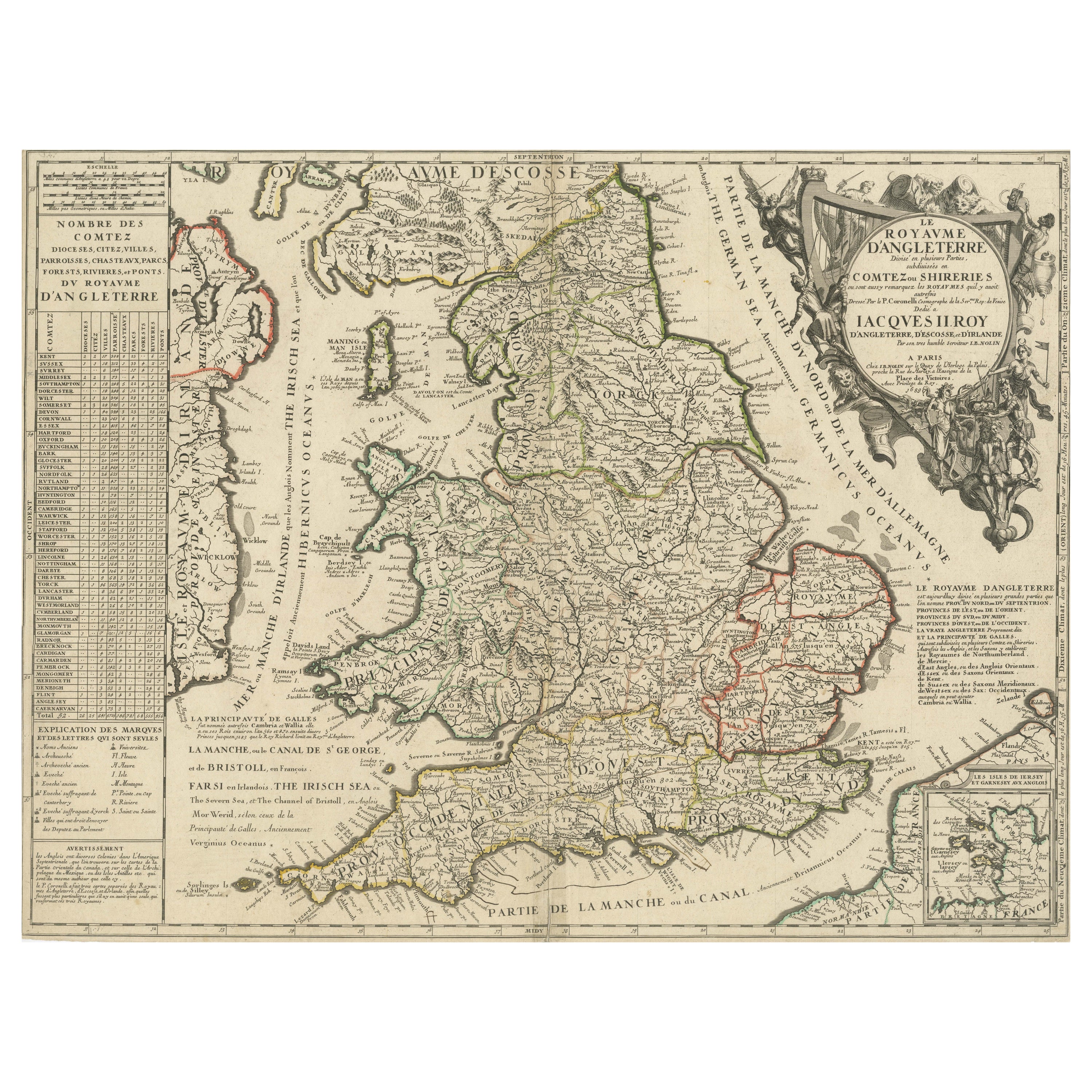
Original Antique Map of England and Wales with Large Cartouche
Located in Langweer, NL
Antique map titled 'Le Royaume d'Angleterre divisé en plusieurs Parties (..)'. Large and rare map of England and Wales by J.B. Nolin after Coronelli. With decorative cartouche, table...
Category
Antique Late 17th Century Maps
Materials
Paper

$419 Sale Price
20% Off
Original Antique Map of England and Wales, with Decorative Cartouche
Located in Langweer, NL
Antique map titled 'England and Wales from the best Authorities'. Original antique map of England and Wales, with decorative cartouche. Engraved by T. Conder. Published circa 1790.
Category
Antique Late 18th Century Maps
Materials
Paper
$152 Sale Price
20% Off
You May Also Like
18th Century Emanuel Bowen Map of County of York, c.1740
By Emanuel Bowen
Located in Royal Tunbridge Wells, Kent
Antique 18th century British rare and original Emanuel Bowen (1694-1767) map of the County of York divided into its Ridings and subdivided into wapontakes, mounted in solid wood fram...
Category
Antique Early 18th Century British Maps
Materials
Paper

Map of Northumberland by Joannem Janssonium 17th century
Located in London, GB
To see our other original maps, scroll down to "More from this Seller" and below it click on "See all from this Seller" - or send us a message if you cannot find the poster you want....
Category
1640s Landscape Prints
Materials
Engraving
Map Southern Scotland Thomas Conder Alex Hogg 1795
Located in BUNGAY, SUFFOLK
A new map of the southern part of Scotland containing the counties of Stirling, Lanerk, Renfrew, Linlithgow, Edinburgh, Peebles, Haddingtoun, Berwick, Selkirk, Roxburgh, Dumfries, Wigtoun, Kirkudbright & Air
Published by Alex Hogg at the Kings Arms...
Category
Antique 18th Century English Georgian Maps
Materials
Paper

17th Century map of Cumberland, UK by Robert Morden
Located in Petworth, West Sussex
Robert Morden (British, circa 1650 – 1703)
A map of Cumberland with hand colouring
An engraving
14.1/4 x 16.5/8 in. (36.5 x 42.5 cm.)
Category
17th Century Academic Landscape Prints
Materials
Engraving
Antique County Map, Shropshire, English, Atlas Engraving, Richard Blome, C.1673
Located in Hele, Devon, GB
This is an antique county map of Shropshire. An English, framed atlas engraving by Richard Blome, dating to the 17th century and later.
A treat for the collector or county native, ...
Category
Antique 17th Century British Restauration Maps
Materials
Glass, Wood, Paper

Great Britain, N. France: A Large 17th C. Hand-colored Map by Sanson and Jaillot
By Nicholas Sanson d
Abbeville
Located in Alamo, CA
This large hand-colored 17th century copperplate engraved map entitled "Le Royaume D Angleterre, distingué en ses Provinces. Par le Sr. Sanson. Geographe du Roy. Presenté A Monseigne...
Category
1690s Landscape Prints
Materials
Engraving

More Ways To Browse
Antique Furniture Northumberland
Taiwan Map
Antique Chicago Maps
Dutch Bible
New Jersey 19th Century
Thailand Map
Antique Coal Mining
Antique Dutch Bible
Antique Louisiana Map
Antique Maps Of Sicily
Iran Map
Map Of Great Britain
Sardinia Map
Antique Map Of Thailand
Antique Wooden Roller
Croatia Map
Kentucky Antique Furniture
Louisiana Antique Furniture