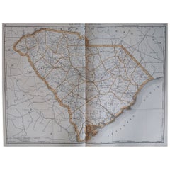
1 of 7
Engraved Map of South Carolina from John Payne
s Book, circa 1799
Price:$700
$875List Price
About the Item
- Creator:John Payne (Artist)
- Dimensions:Height: 16 in (40.64 cm)Width: 17 in (43.18 cm)Depth: 0.75 in (1.91 cm)
- Materials and Techniques:
- Place of Origin:
- Period:1790-1799
- Date of Manufacture:circa 1799
- Condition:Wear consistent with age and use.
- Seller Location:Atlanta, GA
- Reference Number:Seller: 17-ART-0221stDibs: LU827218536552
Authenticity Guarantee
In the unlikely event there’s an issue with an item’s authenticity, contact us within 1 year for a full refund. DetailsMoney-Back Guarantee
If your item is not as described, is damaged in transit, or does not arrive, contact us within 7 days for a full refund. Details24-Hour Cancellation
You have a 24-hour grace period in which to reconsider your purchase, with no questions asked.Vetted Professional Sellers
Our world-class sellers must adhere to strict standards for service and quality, maintaining the integrity of our listings.Price-Match Guarantee
If you find that a seller listed the same item for a lower price elsewhere, we’ll match it.Trusted Global Delivery
Our best-in-class carrier network provides specialized shipping options worldwide, including custom delivery.You May Also Like
Framed 17th Century Map of Cumberland, England by John Speed, 1610
By John Speed
Located in Middleburg, VA
A fascinating and richly detailed antique map of Cumberland County in northwest England, drawn and published by the celebrated English cartographer John Spe...
Category
Antique Early 17th Century English British Colonial Maps
Materials
Copper, Gold Leaf

Antique Framed Pen and Ink on Fabric Map of Cornwall from Early 19th Century
Located in Los Angeles, CA
This English fabric map of Cornwall, rendered in pen-and-ink, showcases exquisite hand-drawn details and charming faded sepia tones. Encased in a classic frame, this piece elegantly ...
Category
Antique Early 19th Century English Drawings
Materials
Walnut, Fabric

$2,475
H 30.5 in W 44.5 in D 1 in
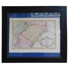
French Framed Copper Engraved Hand Colored Map of Carolina
Georgia, Circa 1757
Located in Charleston, SC
French copper engraved hand colored map of Carolina & Georgia matted under glass with a painted frame, mid-18th century
Category
Antique 1750s French Louis XV Maps
Materials
Glass, Wood, Paint, Paper
$2,800
H 14.5 in W 16.75 in D 1 in
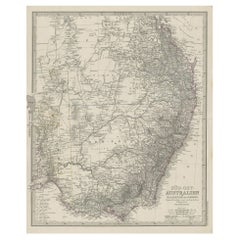
Antique Engraved Map of South East Australia from a German Atlas, 1848
Located in Langweer, NL
Antique map Australia titled 'Süd-Ost Australien'.
Detailed map of South East Australia. Orginates from 'Stieler's Hand Atlas', published in Ge...
Category
Antique 19th Century Maps
Materials
Paper
$95
H 18.12 in W 14.77 in D 0 in
Extremely Large Hand-Drawn Manuscript Map of Surinam, 1830, History of Slavery
Located in Amsterdam, NL
A unique large hand-drawn map of Surinam by Albrecht Helmut Hiemcke (German, 1760-1839)
?
'Colonie Surinaame', 1830
A large hand-drawn and coloured map of the colony of Suri...
Category
Antique Mid-19th Century Surinamer Maps
Materials
Paper

$45,483
Free Shipping
H 34.85 in W 97.05 in D 0.08 in
Large Original Antique Map of South Carolina, USA, 1894
By Rand McNally
Co.
Located in St Annes, Lancashire
Fabulous map of South Carolina
Original color
By Rand, McNally & Co.
Published, 1894
Unframed
Free shipping.
Category
Antique 1890s American Maps
Materials
Paper
Original Antique Map of the American State of South Carolina, 1903
Located in St Annes, Lancashire
Antique map of South Carolina
Published By A & C Black. 1903
Original colour
Good condition
Unframed.
Free shipping
Category
Antique Early 1900s English Maps
Materials
Paper

$49
Free Shipping
H 11.5 in W 16.25 in D 0.07 in
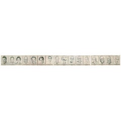
Portrait Gallery of Grand Bostonians from Joe Tecce
s
By Daniel Varoujan Hejinian
Located in Hanover, MA
Framed series of American modern pen and ink drawings, sixteen portraits of Boston "pols" and Italian American civic leaders, all of whom were the famous 'Friends of Joe Tecce's' of the eponymously named restaurant in Boston's North End.
The frame is sixteen feet long by one foot tall...
Category
Vintage 1970s American Mid-Century Modern Drawings
Materials
Plexiglass, Wood, Paper
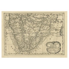
Original Copperplate Engraved Detailed Map of South Africa, ca.1680
Located in Langweer, NL
Antique map titled 'Pays et Coste des Caffres Empires de Monomotapa (..)'.
Detailed map of South Africa. Engraved by Antoine d'Winter for a Dutch edition of Sanson's pocket atlas...
Category
Antique 1680s Maps
Materials
Paper
$344 Sale Price
20% Off
H 9.65 in W 14.57 in D 0 in
Why Draw? 500 Years of Drawings and Watercolors from Bowdoin College, 1st Ed
Located in valatie, NY
Why Draw? 500 Years of Drawings and Watercolors from Bowdoin College, by Joachim Homann. Bowdoin College Museum of Art, Brunswick ME 2017. 1st Ed hardc...
Category
2010s American Books
Materials
Paper

$79
H 11.25 in W 9.75 in D 1 in