Want more images or videos?
Request additional images or videos from the seller
1 of 10
Ethnographic Map of Great Britain and Ireland – Distribution of People, c.1860
Price:$800
$1,056.79List Price
About the Item
- Dimensions:Height: 26.66 in (67.7 cm)Width: 21.93 in (55.7 cm)Depth: 0.02 in (0.5 mm)
- Materials and Techniques:
- Period:
- Date of Manufacture:c.1860
- Condition:General age-related toning, original folding line. Shows overall staining and darker staining in margins. Some wear and creasing, blank verso. Please study image carefully.
- Seller Location:Langweer, NL
- Reference Number:Seller: BG-134651stDibs: LU3054339045892
About the Seller
5.0
Recognized Seller
These prestigious sellers are industry leaders and represent the highest echelon for item quality and design.
Platinum Seller
Premium sellers with a 4.7+ rating and 24-hour response times
Established in 2009
1stDibs seller since 2017
2,813 sales on 1stDibs
Typical response time: 1 hour
Authenticity Guarantee
In the unlikely event there’s an issue with an item’s authenticity, contact us within 1 year for a full refund. DetailsMoney-Back Guarantee
If your item is not as described, is damaged in transit, or does not arrive, contact us within 7 days for a full refund. Details24-Hour Cancellation
You have a 24-hour grace period in which to reconsider your purchase, with no questions asked.Vetted Professional Sellers
Our world-class sellers must adhere to strict standards for service and quality, maintaining the integrity of our listings.Price-Match Guarantee
If you find that a seller listed the same item for a lower price elsewhere, we’ll match it.Trusted Global Delivery
Our best-in-class carrier network provides specialized shipping options worldwide, including custom delivery.You May Also Like
England, Scotland
Ireland: A Hand Colored Map of Great Britain by Tirion
By Isaak Tirion
Located in Alamo, CA
This is a hand-colored double page copperplate map of Great Britain entitled "Nieuwe Kaart van de Eilanden van Groot Brittannien Behelzende de Kon...
Category
Antique Mid-18th Century Dutch Maps
Materials
Paper

$700 Sale Price
20% Off
H 17 in W 20.75 in D 0.07 in
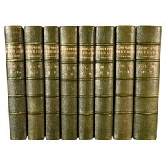
County Seats of the Noblemen
Gentlemen of Great Britain
Ireland (Book)
Located in North Yorkshire, GB
A set of seven beautifully bound volumes in morocco red leather with gilt decorations and crest to front and rear. A stunning collection of this pictorial work of British and Irish c...
Category
Antique 19th Century English Books
Materials
Paper
$3,950 / set
Free Shipping
H 11.25 in W 9 in D 1.5 in
20thC Leather Cased Collection Of Bartholomew Maps Of Great Britain c.1920
Located in Royal Tunbridge Wells, Kent
Antique 20th Century leather-cased collection of Bartholomew British road maps by Edward Stanford Ltd of London. One volume features a map of the entire British Isles, divided into n...
Category
20th Century British Other Maps
Materials
Leather, Paper

$2,609
H 9.45 in W 16.15 in D 4.34 in
Original Antique Map of Ireland- Tipperary and Waterford. C.1840
Located in St Annes, Lancashire
Great map of Tipperary and Waterford
Steel engraving
Drawn under the direction of A.Adlard
Published by How and Parsons, C.1840
Unframed.
Category
Antique 1840s English Maps
Materials
Paper

$35
Free Shipping
H 9.5 in W 6.25 in D 0.07 in
Original Antique Map of Ireland- Kerry. C.1840
Located in St Annes, Lancashire
Great map of Kerry
Steel engraving
Drawn under the direction of A.Adlard
Published by How and Parsons, C.1840
Unframed.
Category
Antique 1840s English Maps
Materials
Paper

Large Original Antique Map of Ireland. C.1900
Located in St Annes, Lancashire
Fabulous map of Ireland
Original color.
Engraved and printed by the George F. Cram Company, Indianapolis.
Published, C.1900.
Unframed.
Free shipping.
Category
Antique 1890s American Maps
Materials
Paper

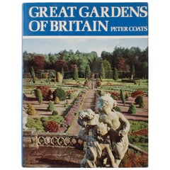
Great Gardens of Britain by Peter Coats
By Peter Coats
Located in valatie, NY
Great Gardens of Britain by Peter Coats. London: Spring Books, 1970. Hardcover with dust jacket. 287 pp. A handsome book on the diversity and quality of British gardens. The book showcases thirty-eight great gardens including natural gardens, wild gardens, formal and historical gardens, terraced gardens, and rhododendron gardens. Included are Newby Hall, Mereworth, Pusey, Sezincote, Powis, Logan, Great Dixter...
Category
20th Century English Books
Materials
Paper
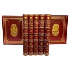
1887-98 Complete Peerage of Great Britain
By George Edward Cokayne
Located in Bath, GB
A beautifully bound first edition set of this important authorativie reference work on the peerage of Britain, by George Edward Cokayne.
The first edition of this work.
Complete in...
Category
Antique Late 19th Century British Books
Materials
Paper
1636 Jansson Map of Ireland Entitled "Comitatus Lageniae, " Ric.a007
Located in Norton, MA
1646 Jansson map entitled
"Procinvia connactiae,"
Ric.a006
Description: The PROVINCE of CONNAVGT 490 x 380From vol 4 of Jansson's Atlas Novus 1646, published in Amsterdam with...
Category
Antique 17th Century Unknown Maps
Materials
Paper

$1,275 / set
H 19.3 in W 23.78 in D 0.4 in
Gilpin, Wm: Observations... on Great Britain, and High-Lands of Scotland, 2 vols
Located in Middletown, NY
This is Gilpin's third in his series of works tracing picturesque beauty in British natural landscapes. In it he portrays the landscapes of Scottish Highlands, and describes them lyrically in his text. Prefacing the list of Prints at the end of the second volume, the author says "With regards to the prints, which adorn these volumes, I can only say..... that few of them pretend to be 'exact portraits.' They in general 'only characterize the countries,' through which the reader is carried." The illustrations, based on Gilpin's sketches, were etched by his nephew William Sawrey Gilpin using the newly invented aquatint process. This volume also includes a technical discourse about drawing and the mixing of colors, including a chart (vol. 1, p. 131-134)
William Gilpin (1724 – 1804) was an English artist, Church of England cleric, schoolmaster and author. He is best known as a travel writer and as one of those who originated the idea of the picturesque. Gilpin's tour journals circulated in manuscript to friends such as the poet William Mason and a wider circle including Thomas Gray...
Category
Antique Late 18th Century English Books
Materials
Leather, Paper
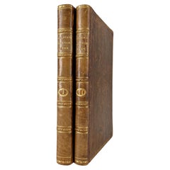
$800 / set
H 8.75 in W 5.25 in D 1.75 in
More From This Seller
View AllRare Small Antique Map of Great Britain and Ireland
Located in Langweer, NL
Antique map titled 'La Grande Bretagne et Irlande'. Small antique map of Great Britain and Ireland. Source unknown, to be determined. Publ...
Category
Antique Mid-18th Century Maps
Materials
Paper
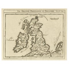
$220 Sale Price
20% Off
1788 Map of Europe - France, Italy, Spain, Germany, Great Britain
Ireland
Located in Langweer, NL
Title: "1788 Map of Europe - France, Italy, Spain, Germany, Great Britain & Ireland by D'Anville"
Description:
This detailed map of Europe, titled "First Part of the Map of Europe...
Category
Antique 1780s Maps
Materials
Paper
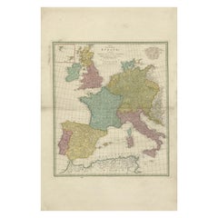
$1,076 Sale Price
20% Off
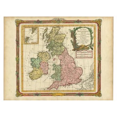
Antique Map of Great Britain and Ireland by Brion de la Tour, 1766
Located in Langweer, NL
Antique map titled 'Les Isles Britanniques (..).'
Attractive map of Great Britain surrounded by an engraved border printed from a separate coppe...
Category
Antique 18th Century Maps
Materials
Paper
Detailed Antique Map of Britain, Wales and the Coast of Ireland
Located in Langweer, NL
Antique map titled 'Carta d'Inghilterra e del Principato di Galles'. Detailed map of Britain, Wales and the coast of Ireland with a list of counties. This map originates from 'Nuovo ...
Category
Antique Mid-19th Century Maps
Materials
Paper

$249 Sale Price
20% Off
Interesting Map of Great Britain and Northern Europe with various Illustrations
Located in Langweer, NL
Antique map titled 'Itinera Varia Auctoris'. Very interesting map of Great Britain and Northern Europe. The map shows Edwards' journeys between 1716-1730 to study his beloved birds a...
Category
Antique Mid-18th Century Maps
Materials
Paper
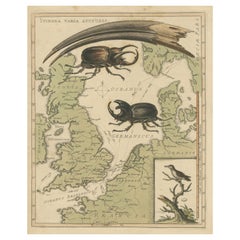
$422 Sale Price
20% Off
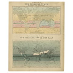
Antique Map of the Distribution of Air and Rain by Reynolds, 1843
Located in Langweer, NL
Two antique world maps on one sheet. The upper map shows the distribution of the currents of air and variable winds over the world. The lower meteorological map shows the distributio...
Category
Antique 19th Century Maps
Materials
Paper
Still Thinking About These?
All Recently ViewedMore Ways To Browse
Mid Century Modern Danish Teak Dining Tables
Long Rug Runners
Pair Arm Chairs
Sterling Silver Dinner Sets
United Chair Company
Italian Beech Chairs
Shirvan Rugs
Spain Marble
Vintage Danish Tables And Chairs
1960s Glass Top Coffee Table
Black Glass Coffee Tables
Burnt Wood
Mid Century Wrought Iron Chairs
Earth Toned Rug
Black Marble Table Vintage
Goblets
Mid Century Modern Yellow Chair
Paulin Pierre