Items Similar to Europe Map – Political Divisions and Borders, Published in 1858


Video Loading
Want more images or videos?
Request additional images or videos from the seller
1 of 11
Europe Map – Political Divisions and Borders, Published in 1858
$405.14
£301.77
€340
CA$557.91
A$607.27
CHF 321.77
MX$7,303.40
NOK 4,091.26
SEK 3,749.19
DKK 2,590.57
About the Item
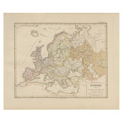
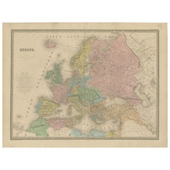
Europe Map – Political Divisions and Borders 1858
This fine antique print shows Europe with its political divisions titled “Europa zur Übersicht der politischen Verhältnisse” meaning “Europe showing political conditions.” Published in 1858 by Justus Perthes in Gotha as part of Adolf Stieler’s acclaimed Hand-Atlas, this map presents the continent with national borders clearly outlined and coloured, displaying the geopolitical landscape prior to German unification and major 19th-century territorial changes.
The map includes detailed labelling of cities, rivers, and mountain ranges, extending from Iceland and Greenland in the northwest to the Caspian Sea and Caucasus in the east, and down to North Africa in the south. It shows the Austrian Empire, Prussia, the Ottoman Empire, and the Russian Empire with their extensive territories, as well as smaller states such as the Italian duchies and the German principalities, reflecting the complex political structure of Europe before the late 19th-century unifications.
Created under the editorial supervision of Hrn. v. Stülpnagel and cartographer Heinrich Berghaus, the engraving demonstrates Stieler’s commitment to accuracy and clarity, making it an essential reference for historians, collectors, and educators today.
Technique: Copperplate engraving with original hand colouring to delineate political borders and territories, using subtle yet precise hues for each region. The German titles and annotations are engraved with exceptional clarity, typical of Stieler’s publishing standards.
Condition summary: Excellent condition with strong impression, minimal age toning, no tears or repairs. Colours remain vivid and paper is firm and stable.
Framing tips: This political map of Europe will look distinguished in a dark wood or black frame to emphasise its historical and cartographic importance. Pair with a wide ivory or cream mount to soften the presentation and draw attention to its detailed engraving. UV-protective glass is recommended to maintain the crisp lines and original colours for long-term preservation.
- Dimensions:Height: 14.77 in (37.5 cm)Width: 17.88 in (45.4 cm)Depth: 0.01 in (0.2 mm)
- Materials and Techniques:Paper,Engraved
- Place of Origin:
- Period:
- Date of Manufacture:1857
- Condition:Condition summary: Excellent condition with strong impression, minimal age toning, no tears or repairs. Colours remain vivid and paper is firm and stable.
- Seller Location:Langweer, NL
- Reference Number:Seller: BG-05552-121stDibs: LU3054345810642
About the Seller
5.0
Recognized Seller
These prestigious sellers are industry leaders and represent the highest echelon for item quality and design.
Platinum Seller
Premium sellers with a 4.7+ rating and 24-hour response times
Established in 2009
1stDibs seller since 2017
2,824 sales on 1stDibs
Typical response time: 1 hour
- ShippingRetrieving quote...Shipping from: Langweer, Netherlands
- Return Policy
More From This Seller
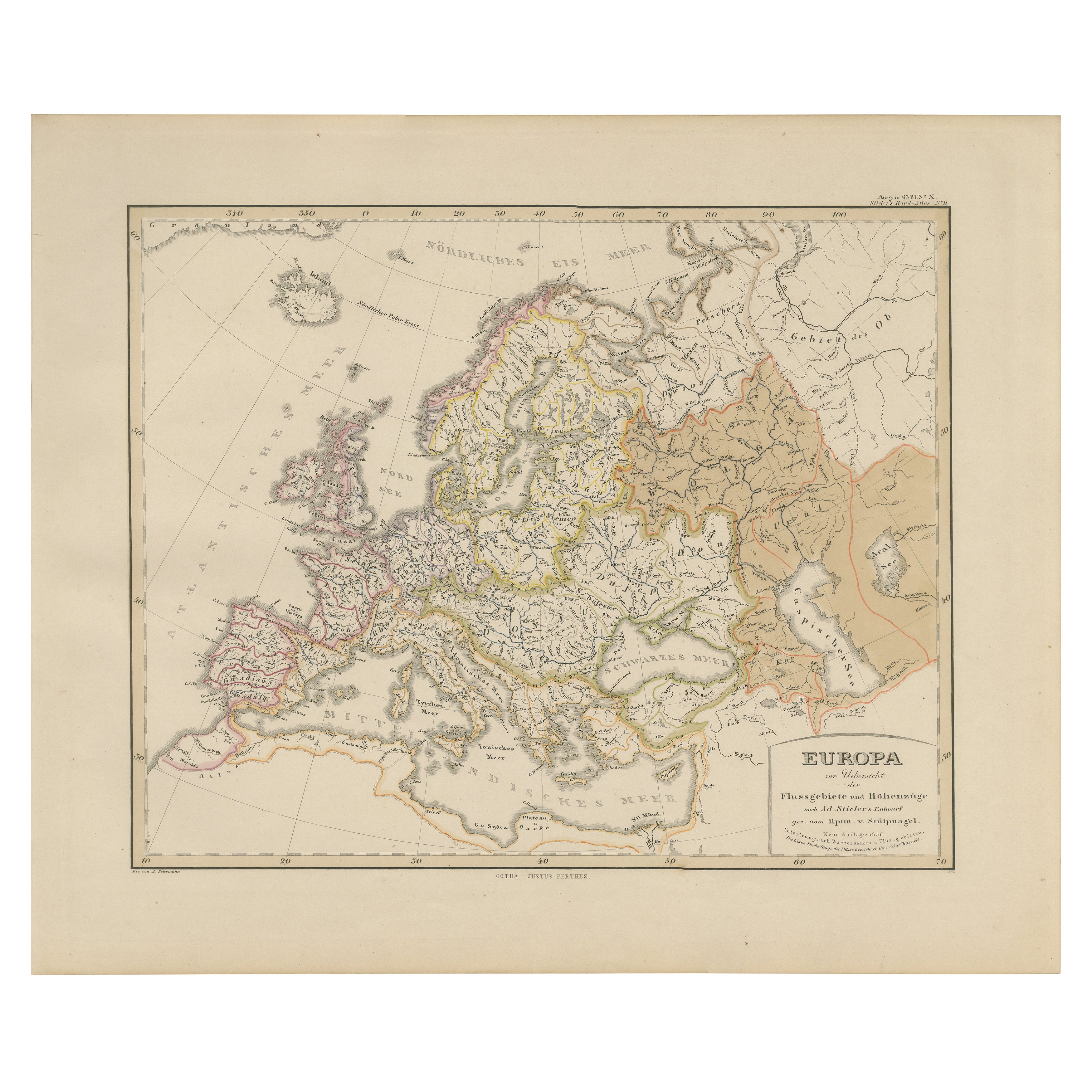
View AllEurope Map – Rivers, Watersheds and Elevation, Published in 1857
Located in Langweer, NL
Europe Map – Rivers, Watersheds and Elevation 1857
This beautiful antique print shows Europe with its river systems and watershed regions, titled “Europa zur Übersicht der Flussgebi...
Category
Antique Mid-19th Century German Maps
Materials
Paper
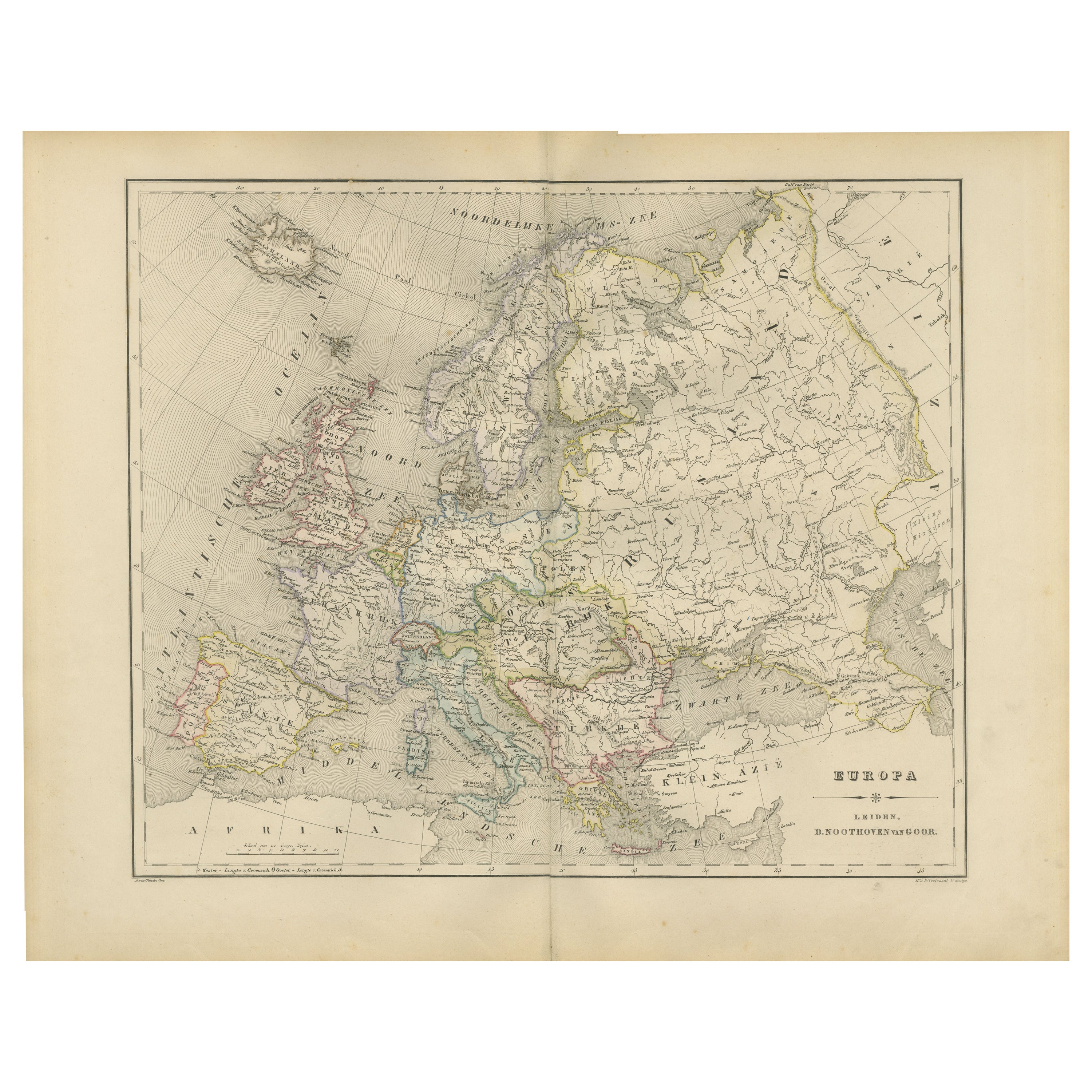
Political Map of Europe – Nieuwe Hand-Atlas by Frijlink
van Otterloo, 1876
Located in Langweer, NL
Title: Political Map of Europe – Nieuwe Hand-Atlas by Frijlink & van Otterloo, 1876
Description:
This 19th-century Dutch map titled “Europa” was published in 1876 in the Nieuwe Hand...
Category
Antique 1870s Dutch Maps
Materials
Paper
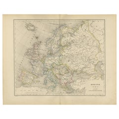
Antique Map of Europe – Political Divisions by Andriveau-Goujon, Paris 1861
Located in Langweer, NL
Antique Map of Europe – Political Divisions by Andriveau-Goujon, Paris 1861
This beautifully engraved and hand-colored antique map of Europe was published in 1861 by the Parisian ca...
Category
Antique Mid-19th Century French Maps
Materials
Paper
Antique Map of Europe by W. G. Blackie, 1859
Located in Langweer, NL
Antique map titled 'Europe'. Original antique map of Europe. This map originates from ‘The Imperial Atlas of Modern Geography’. Published by W. G. Blackie, 1859.
Category
Antique Mid-19th Century Maps
Materials
Paper

$238 Sale Price
20% Off
Antique Map of Europe, 1903, with Intricate Political Boundaries and Rich Detail
Located in Langweer, NL
Title: Antique Map of Europe, 1903, with Intricate Political Boundaries and Rich Detail
Description:
This antique map, titled "Europe," is a finely engraved and beautifully colored ...
Category
Early 20th Century Maps
Materials
Paper

Political Map of Europe: Early 19th Century, from the 1802 Tardieu Atlas
Located in Langweer, NL
Antique Map Description
Title: Carte Générale et Politique de l'Europe
Publication Details:
- **Atlas Title:** Nouvel Atlas Universel de Géographie Ancienne et Moderne
- **Purpose...
Category
Antique Early 1800s French Maps
Materials
Paper

$457 Sale Price
20% Off
You May Also Like
Map of Europe, 1844
Located in Houston, TX
Over 150 year old engraved map of Europe by Olney from 1844. Original hand color. Shows Northern Europe, Prussia and Germany.
Original antique map o...
Category
1840s More Prints
Materials
Ink, Watercolor, Handmade Paper

Original Antique Map of Europe, Arrowsmith, 1820
Located in St Annes, Lancashire
Great map of Europe
Drawn under the direction of Arrowsmith.
Copper-plate engraving.
Published by Longman, Hurst, Rees, Orme and Brown, 1820
...
Category
Antique 1820s English Maps
Materials
Paper

Large Original Antique Map of Europe by Sidney Hall, 1847
Located in St Annes, Lancashire
Great map of Europe
Drawn and engraved by Sidney Hall
Steel engraving
Original colour outline
Published by A & C Black. 1847
Unframed
Free shipping.
Category
Antique 1840s Scottish Maps
Materials
Paper

1870 "Johnson
s Europe" Map Published by A. J. Johnson
Located in Colorado Springs, CO
Presented is an original 1870 "Johnson’s Europe" map. First published in 1864, this map was issued as pages 87 and 88 in the 1870 edition of “Johnson's New Illustrated (Steel Plate) ...
Category
Antique 1870s American Victorian Maps
Materials
Paper

1853 Map of "Russia in Europe Including Poland" Ric.r016
Located in Norton, MA
Description
Russia in Europe incl. Poland by J Wyld c.1853
Hand coloured steel engraving
Dimension: Paper: 25 cm W x 33 cm H ; Sight: 22 cm W x 28 cm H
Condition: Good ...
Category
Antique 19th Century Unknown Maps
Materials
Paper

1790 Thomas Stackhouse Map, Entitled "Russia in Europe, " , Ric.a004
Located in Norton, MA
1790 Thomas Stackhouse map, entitled
"Russia in Europe"
Ric.a004
Stackhouse, Thomas
Russia in Europe [map]
London: T. Stackhouse, 1783. Map. Matted hand-colored copper engraving. Image size: 14.5 x 15.25 inches. Mat size: 22.75 x 23.75 inches. A beautiful example of this map of Eastern Europe...
Category
Antique 17th Century Unknown Maps
Materials
Paper

More Ways To Browse
Austrian Empire
Iceland Antique
Icelandic Antique
China Silk Rug
Chrome Glass Coffee Tables
Antique Italian Chairs
Beni Ourain Rugs
French Iron And Glass Table
Glass Top Wood Base Coffee Tables
T Chair
Antique Silver Basket
Antique Walkers
Ebony Wood Furniture
Opalescent Glass
Pair Of Danish Chairs
Veneer Dining Tables
1970 Italian Armchair
Furniture Uk