Items Similar to Europe Map by Rigobert Bonne – Enlightenment Cartography c.1780


Want more images or videos?
Request additional images or videos from the seller
1 of 11
Europe Map by Rigobert Bonne – Enlightenment Cartography c.1780
$396.63
£293.79
€330
CA$542.57
A$591.38
CHF 312.66
MX$7,119.04
NOK 3,968.37
SEK 3,638.19
DKK 2,514.42
About the Item
Europe Map by Rigobert Bonne – Enlightenment Cartography c.1780
DESCRIPTION
This detailed map of Europe illustrates political and geographic divisions prior to the Napoleonic era. Compiled by Rigobert Bonne, it presents cities, rivers, mountain systems, and regional boundaries with clarity and balance. France, Italy, the German states, and Eastern Europe are carefully delineated, while Scandinavia and Russia reflect expanding cartographic confidence. Longitude measured from Paris places the map firmly within French scientific tradition. Intended for reference and instruction, the sheet captures Europe at a moment of political complexity and cultural exchange. Its dense engraving and sober presentation make it both historically informative and visually compelling.
KEYWORDS
Europe map, Paris meridian, London Paris Rome Vienna, Rhine Danube Alps, Grand Tour geography, pre-Napoleonic Europe
CONDITION REPORT
Light age toning. Central fold. Minor edge wear and small stains visible on close inspection.
FRAMING TIPS
Neutral mat and classic gilt or dark wood frame to balance dense engraved detail.
Technique: Engraving
Maker: Rigobert Bonne, France, circa 1780
- Dimensions:Height: 10.24 in (26 cm)Width: 16.15 in (41 cm)Depth: 0.01 in (0.2 mm)
- Materials and Techniques:Paper,Engraved
- Place of Origin:
- Period:
- Date of Manufacture:Circa 1780
- Condition:Light age toning. Central fold. Minor edge wear and small stains visible on close inspection.
- Seller Location:Langweer, NL
- Reference Number:Seller: BG-14105-31stDibs: LU3054348107782
About the Seller
5.0
Recognized Seller
These prestigious sellers are industry leaders and represent the highest echelon for item quality and design.
Platinum Seller
Premium sellers with a 4.7+ rating and 24-hour response times
Established in 2009
1stDibs seller since 2017
2,813 sales on 1stDibs
Typical response time: 1 hour
- ShippingRetrieving quote...Shipping from: Langweer, Netherlands
- Return Policy
More From This Seller
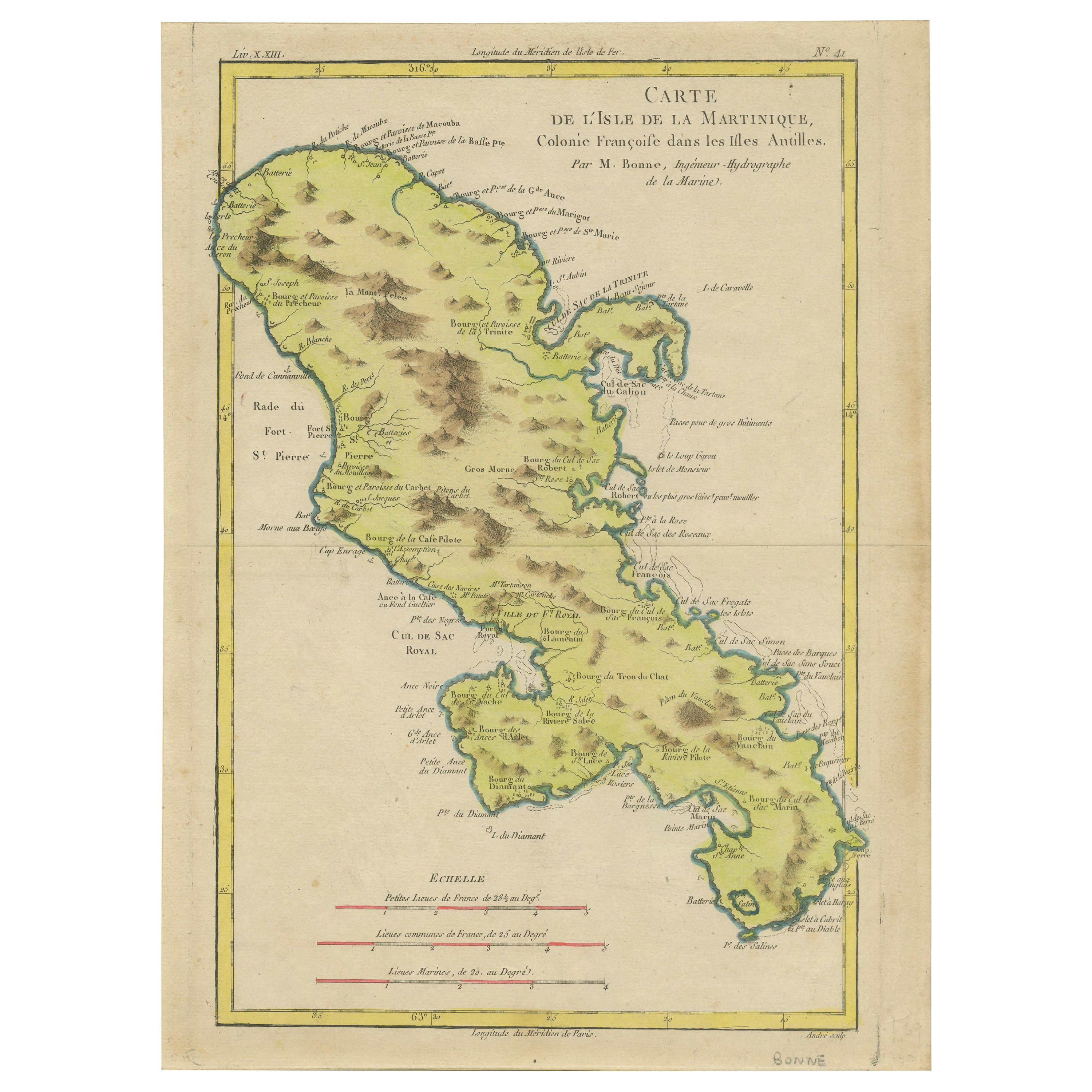
View AllAntique Map of Martinique by Rigobert Bonne, Circa 1780
Located in Langweer, NL
Antique map titled 'Carte de l'Isle de la Martinique Colonie Francoise dans les Isles Antilles'. Detailed map of the French Island of Martinique.
Many towns and harbours, anchor pl...
Category
Antique 18th Century French Maps
Materials
Paper
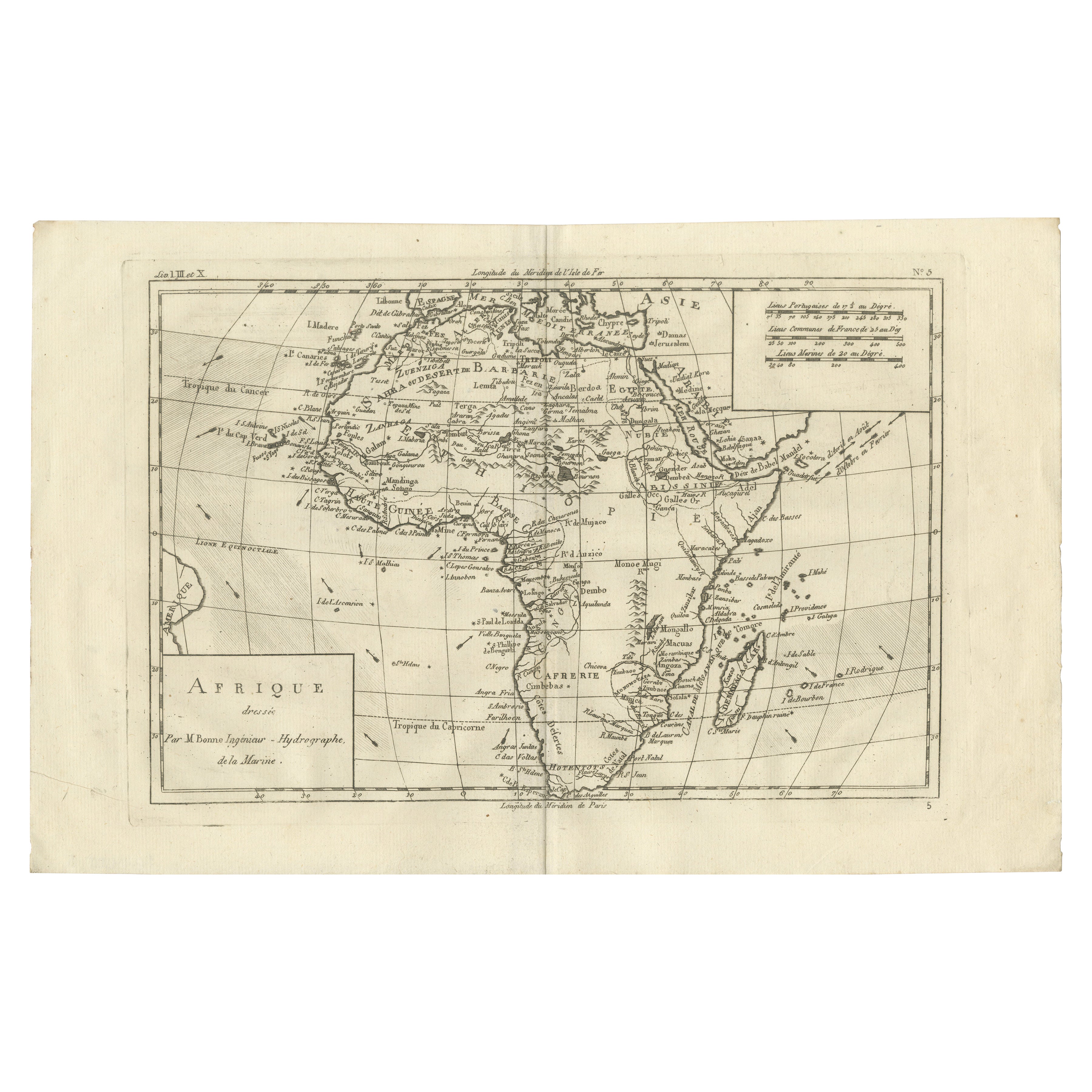
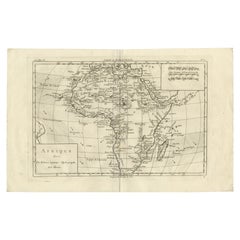
Africa Map by Rigobert Bonne – Pre-Colonial Geography c.1780
Located in Langweer, NL
Africa Map by Rigobert Bonne – Pre-Colonial Geography c.1780
DESCRIPTION
This map of Africa captures European geographic knowledge prior to large-scale colonial penetration. Engrave...
Category
Antique Late 18th Century French Maps
Materials
Paper
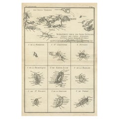
Map of Virgin Islands and Lesser Antilles by Rigobert Bonne, c. 1780
Located in Langweer, NL
Map of Virgin Islands and Lesser Antilles by Rigobert Bonne, c. 1780
This fine antique map is titled 'Supplément pour les Isles Antilles, extrait des cartes angloises' and was engraved by Rigobert Bonne, Ingénieur-Hydrographe de la Marine, around 1780. It depicts:
Upper half:
* The Virgin Islands (*Les Isles Vierges*), including:
* St. Thomas
* St. John
* Tortola
* Virgin Gorda
* Jost Van Dyke
* Surrounding smaller islands and passages.
* Parts of Puerto Rico visible left.
Lower half:
Nine inset maps of individual Caribbean islands with coastal details:
1. I. de la Barboude (Barbuda)
2. I. St. Christophe (St. Kitts)
3. I. Antigoa (Antigua)
4. I. de la Dominique (Dominica)
5. I. de Sainte Lucie (St. Lucia)
6. I. de la Barbade (Barbados)
7. I. de St. Vincent
8. I. de la Grenade (Grenada)
9. I. de Tabago (Tobago)
Features:
* Coastal names, bays, capes, and harbours noted.
* Fine clear engraving typical of Bonne’s atlases for maritime use.
* Scale bar with French lieues marines.
Engraver: Rigobert Bonne
Date: circa 1780
Published in: Atlas Encyclopédique
Condition:
Good dark impression on laid paper with wide margins. Some slight toning along centre fold and faint edge wear consistent with age. Original platemark visible.
Framing suggestions:
Display with other Bonne Caribbean or West Indies maps in a travel, history, or colonial themed wall. Ideal floated in a black or walnut wood frame with archival matting to preserve the crisp engraving.
Keywords:
Rigobert Bonne Caribbean maps...
Category
Antique 1780s French Maps
Materials
Paper
Antique Map of Europe by R. Bonne, 1780
Located in Langweer, NL
A fine example of Rigobert Bonne and Guilleme Raynal’s 1780 map of Europe. Drawn by R. Bonne for G. Raynal’s Atlas de Toutes les Parties Connues du Globe Terrestre, Dressé pour l'His...
Category
Antique Late 18th Century French Maps
Materials
Paper

$151 Sale Price
30% Off
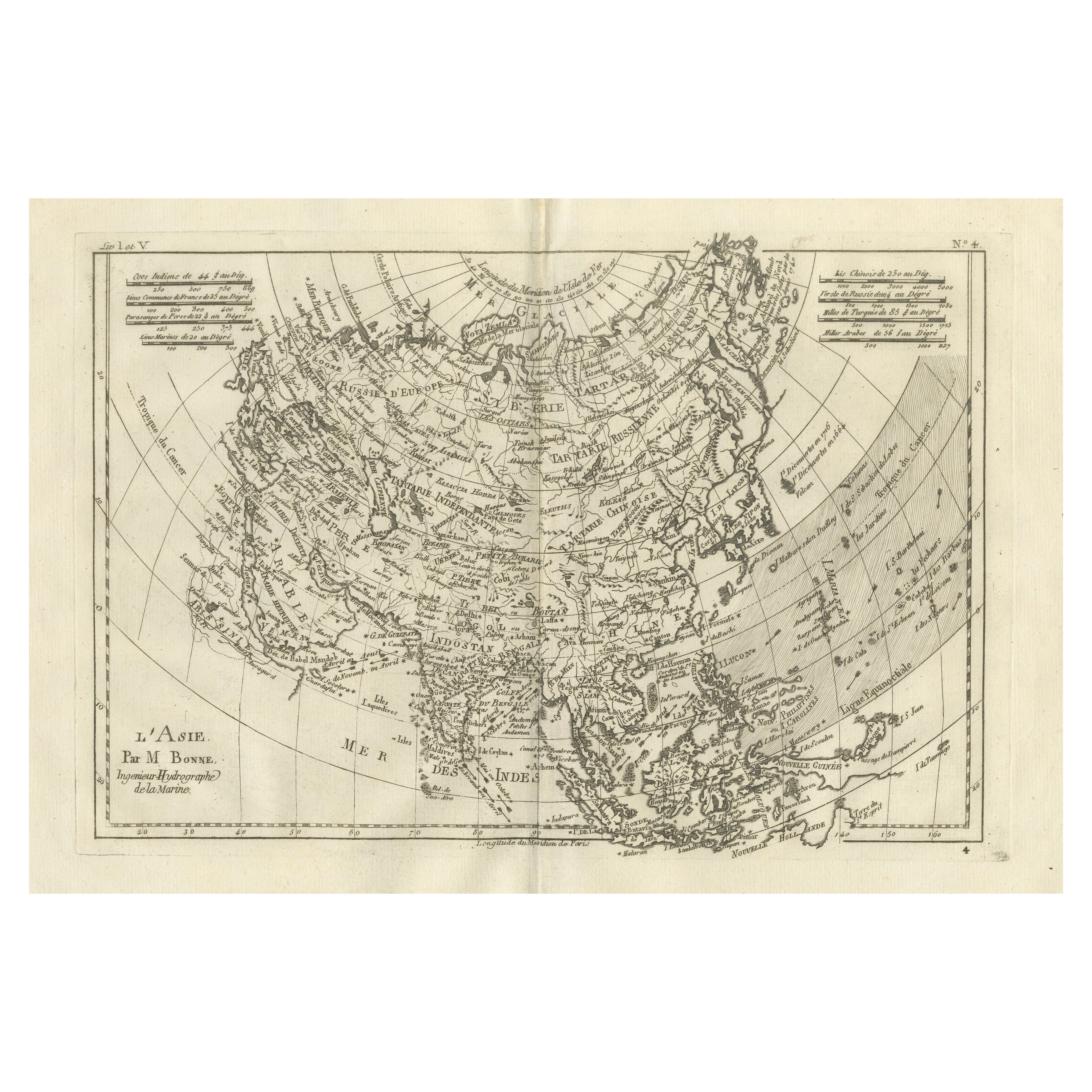
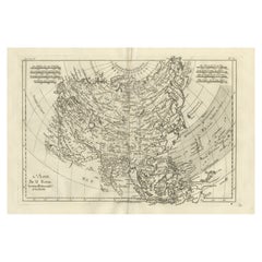
Asia in the Age of Exploration – Antique Map by Rigobert Bonne, c.1780
Located in Langweer, NL
Asia in the Age of Exploration – Antique Map by Rigobert Bonne, c.1780
DESCRIPTION
This engraved map of Asia reflects European geographic understanding during the late Enlightenment...
Category
Antique Late 18th Century French Maps
Materials
Paper
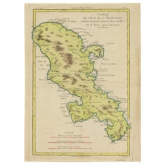
Martinique Map by Rigobert Bonne – French Antique Map, c.1768
Located in Langweer, NL
Map of Martinique by Rigobert Bonne, circa 1768
This is a detailed antique map of Martinique titled “Isle de la Martinique,” engraved by Rigobert Bonne around 1768 for the Atlas Encyclopédique. Bonne, a renowned French hydrographer and successor to Bellin, is celebrated for his scientifically precise and elegantly engraved maps.
The map shows Martinique with its mountainous interior, rivers, and settlements labelled, including Fort Royal, Fort St. Pierre, Le Marin, and Le Prêcheur. Coastal features, bays, and capes are marked, along with anchorages important for maritime navigation in the 18th century. The depiction includes relief shown pictorially, characteristic of Bonne’s cartographic style, enhancing both geographic understanding and aesthetic appeal.
This copperplate engraving retains original hand colouring outlining the coastlines in delicate blue and brown tones, typical for the period. It served as a key reference for scholars, navigators, and colonial administrators during France’s colonial presence in the Caribbean.
Condition:
Good condition overall. A strong impression with bright, original hand-colour outlines. General age toning, faint offsetting, and a vertical fold as issued in the atlas. Margins ample all around for framing.
Framing suggestions:
This historic Caribbean map...
Category
Antique 1760s French Maps
Materials
Paper

You May Also Like
Antique Town Plan Map, Poole, English, Framed Cartography, Georgian, Circa 1780
Located in Hele, Devon, GB
This is an antique town plan map of Poole in Dorset. An English, framed atlas engraving, dating to the 18th century and later.
Fascinating cartography with annotated streets and pl...
Category
Antique Late 18th Century British George III Maps
Materials
Glass, Wood, Paper

Vintage Reproduction 17th Century Map of Europe, American, Cartography, Blaeuw
Located in Hele, Devon, GB
This is a vintage reproduction map of Europe. An American, paper stock cartography print in frame after the work by Blaeuw, dating to the late 20t...
Category
Late 20th Century Central American Mid-Century Modern Maps
Materials
Glass, Wood, Paper

Antique Lithography Map, Bedfordshire, English, Framed Engraving, Cartography
Located in Hele, Devon, GB
This is an antique lithography map of Bedfordshire. An English, framed atlas engraving of cartographic interest, dating to the mid 19th century and...
Category
Antique Mid-19th Century British Victorian Maps
Materials
Wood

Antique Lithography Map, Northumberland, English, Framed, Engraving, Cartography
Located in Hele, Devon, GB
This is an antique lithography map of Northumberland. An English, framed atlas engraving of cartographic interest, dating to the mid 19th century a...
Category
Antique Mid-19th Century British Victorian Maps
Materials
Wood

Antique Lithography Map, Worcestershire, English, Framed Engraving, Cartography
Located in Hele, Devon, GB
This is an antique lithography map of Worcestershire. An English, framed atlas engraving of cartographic interest, dating to the early 19th centur...
Category
Antique Early 19th Century British Regency Maps
Materials
Wood
Antique Lithography Map, Northamptonshire, English, Framed Cartography, C.1860
Located in Hele, Devon, GB
This is an antique lithography map of Northamptonshire. An English, framed atlas engraving of cartographic interest, dating to the mid 19th century...
Category
Antique Mid-19th Century British Victorian Maps
Materials
Wood
