Items Similar to Europe Map – Rivers, Watersheds and Elevation, Published in 1857


Video Loading
Want more images or videos?
Request additional images or videos from the seller
1 of 11
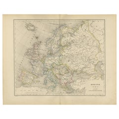
Europe Map – Rivers, Watersheds and Elevation, Published in 1857
$432.68
£320.50
€360
CA$591.90
A$645.14
CHF 341.08
MX$7,766.23
NOK 4,329.13
SEK 3,968.93
DKK 2,743
About the Item
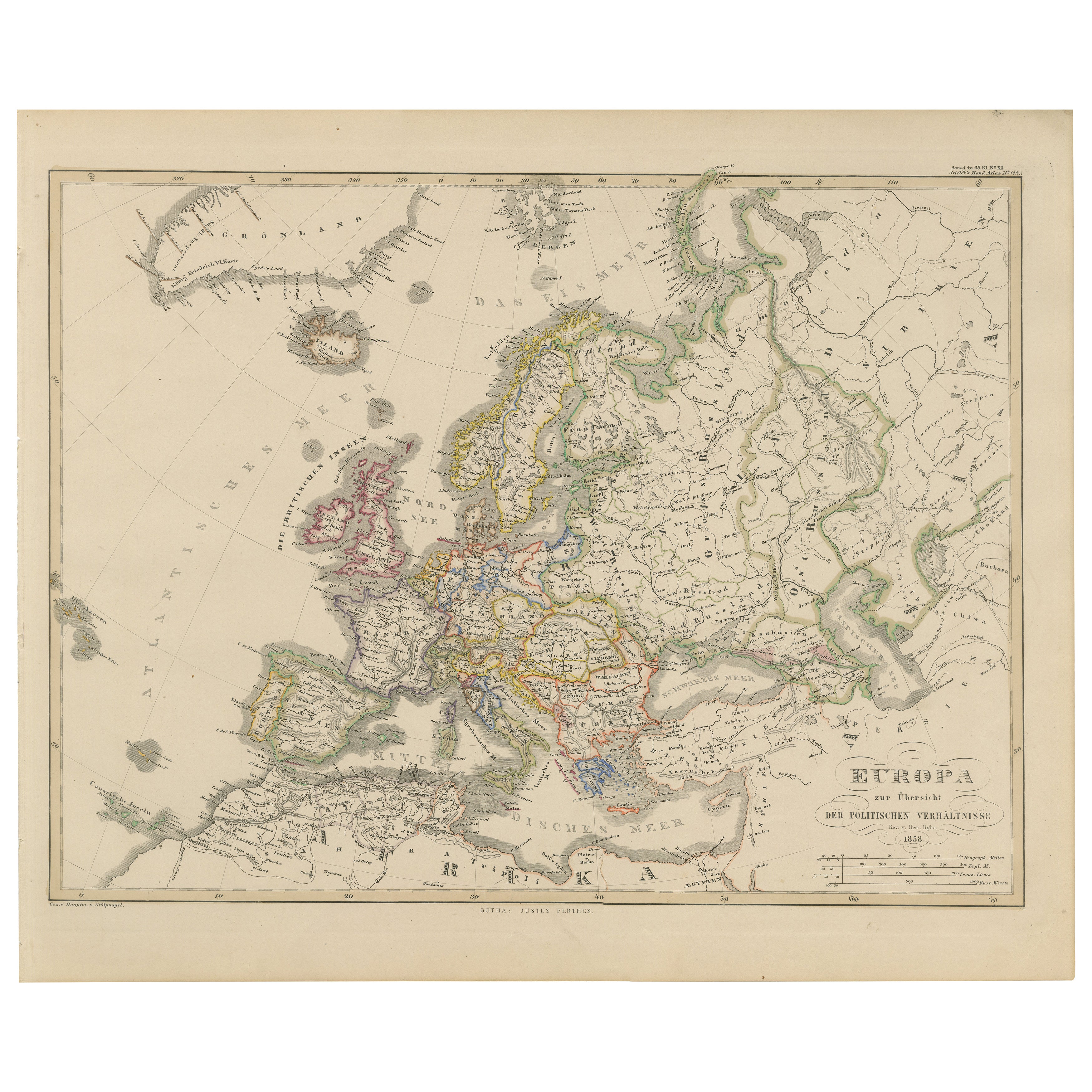
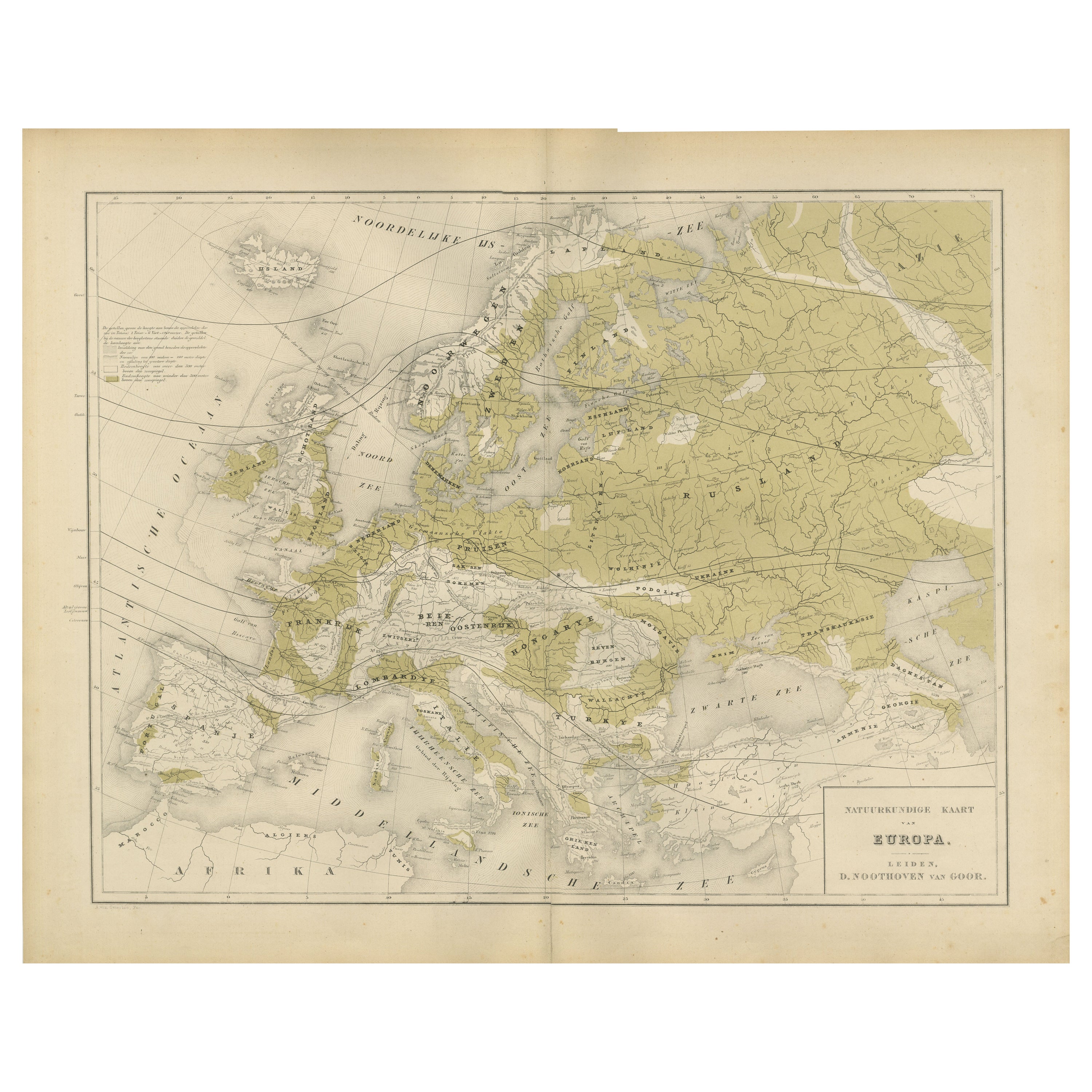
Europe Map – Rivers, Watersheds and Elevation 1857
This beautiful antique print shows Europe with its river systems and watershed regions, titled “Europa zur Übersicht der Flussgebiete und Bodenhöhe” meaning “Europe showing river basins and land elevations.” The map highlights Europe’s major drainage basins, including the Volga, Danube, Rhine, and other principal river systems, with fine detail of mountain ranges and elevations throughout the continent.
Published in 1857 by Justus Perthes in Gotha as part of Adolf Stieler’s famous Hand-Atlas, this engraving was prepared under the supervision of cartographer Heinrich Berghaus with contributions from Hrn. v. Stülpnagel. Stieler’s maps are highly regarded for their scientific accuracy and elegant presentation, making them indispensable references in European geography during the 19th century.
This map is significant as it combines hydrological and topographical information, illustrating how Europe’s rivers shape its natural and human geography. The delineation of river basins alongside elevation shading provides insight into continental drainage patterns, supporting historical studies in geography, settlement development, trade routes, and environmental history.
Technique: Copperplate engraving with original hand colouring to differentiate political boundaries and river basins. German titles and annotations are engraved with clarity and precision typical of Stieler’s atlases.
Condition summary: Excellent condition with strong impression, minimal age toning, and no tears, repairs, or significant foxing. Colours remain vivid and the paper is firm and stable.
Framing tips: This detailed map will look refined in a dark wood or black frame to enhance its scientific and historical presentation. A wide cream or ivory mount will create balance and focus attention on the engraving. UV-protective glass is recommended to preserve the engraved lines and original colouring for long-term display.
- Dimensions:Height: 14.77 in (37.5 cm)Width: 17.88 in (45.4 cm)Depth: 0.01 in (0.2 mm)
- Materials and Techniques:Paper,Engraved
- Place of Origin:
- Period:
- Date of Manufacture:1857
- Condition:Condition summary: Excellent condition with strong impression, minimal age toning, and no tears, repairs, or significant foxing. Colours remain vivid and the paper is firm and stable.
- Seller Location:Langweer, NL
- Reference Number:Seller: BG-05552-111stDibs: LU3054345810612
About the Seller
5.0
Recognized Seller
These prestigious sellers are industry leaders and represent the highest echelon for item quality and design.
Platinum Seller
Premium sellers with a 4.7+ rating and 24-hour response times
Established in 2009
1stDibs seller since 2017
2,811 sales on 1stDibs
Typical response time: 1 hour
- ShippingRetrieving quote...Shipping from: Langweer, Netherlands
- Return Policy
More From This Seller
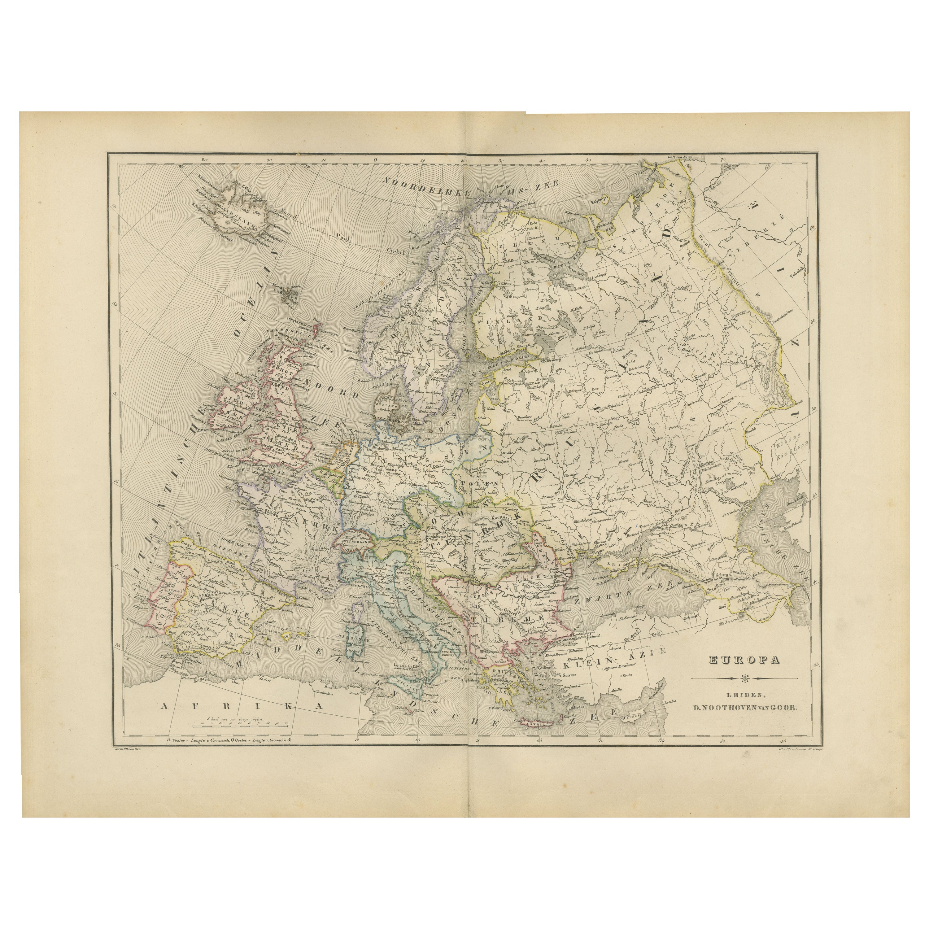
View AllEurope Map – Political Divisions and Borders, Published in 1858
Located in Langweer, NL
Europe Map – Political Divisions and Borders 1858
This fine antique print shows Europe with its political divisions titled “Europa zur Übersicht der politischen Verhältnisse” meanin...
Category
Antique Mid-19th Century German Maps
Materials
Paper
Antique Map of Europe, 1903, with Intricate Political Boundaries and Rich Detail
Located in Langweer, NL
Title: Antique Map of Europe, 1903, with Intricate Political Boundaries and Rich Detail
Description:
This antique map, titled "Europe," is a finely engraved and beautifully colored ...
Category
Early 20th Century Maps
Materials
Paper

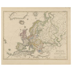
Political Map of Europe – Nieuwe Hand-Atlas by Frijlink
van Otterloo, 1876
Located in Langweer, NL
Title: Political Map of Europe – Nieuwe Hand-Atlas by Frijlink & van Otterloo, 1876
Description:
This 19th-century Dutch map titled “Europa” was published in 1876 in the Nieuwe Hand...
Category
Antique 1870s Dutch Maps
Materials
Paper
Antique Map of Europe by W. G. Blackie, 1859
Located in Langweer, NL
Antique map titled 'Europe'. Original antique map of Europe. This map originates from ‘The Imperial Atlas of Modern Geography’. Published by W. G. Blackie, 1859.
Category
Antique Mid-19th Century Maps
Materials
Paper

$240 Sale Price
20% Off
Physical Map of Europe – Nieuwe Hand-Atlas by Frijlink
van Otterloo, 1876
Located in Langweer, NL
Title: Northern Hemisphere Map Centered on the North Pole, Leiden 1876
Description:
This 19th-century Dutch map titled “Noordpoolkaart” (Map of the North Pole) was published in 1876...
Category
Antique 1870s Dutch Maps
Materials
Paper
Antique Map of the Europe Continent, 1880
Located in Langweer, NL
Antique map titled 'Europe'. Old map of the European continent. This map originates from 'Géographie Universelle Atlas-Migeon' by J. Migeon.
Artists an...
Category
Antique 19th Century Maps
Materials
Paper

You May Also Like
Map of Europe, 1844
Located in Houston, TX
Over 150 year old engraved map of Europe by Olney from 1844. Original hand color. Shows Northern Europe, Prussia and Germany.
Original antique map o...
Category
1840s More Prints
Materials
Ink, Watercolor, Handmade Paper

1870 "Johnson
s Europe" Map Published by A. J. Johnson
Located in Colorado Springs, CO
Presented is an original 1870 "Johnson’s Europe" map. First published in 1864, this map was issued as pages 87 and 88 in the 1870 edition of “Johnson's New Illustrated (Steel Plate) ...
Category
Antique 1870s American Victorian Maps
Materials
Paper

Original Antique Map of Europe, Arrowsmith, 1820
Located in St Annes, Lancashire
Great map of Europe
Drawn under the direction of Arrowsmith.
Copper-plate engraving.
Published by Longman, Hurst, Rees, Orme and Brown, 1820
...
Category
Antique 1820s English Maps
Materials
Paper

Large Original Antique Map of Europe by Sidney Hall, 1847
Located in St Annes, Lancashire
Great map of Europe
Drawn and engraved by Sidney Hall
Steel engraving
Original colour outline
Published by A & C Black. 1847
Unframed
Free shipping.
Category
Antique 1840s Scottish Maps
Materials
Paper

1790 Thomas Stackhouse Map, Entitled "Russia in Europe, " , Ric.a004
Located in Norton, MA
1790 Thomas Stackhouse map, entitled
"Russia in Europe"
Ric.a004
Stackhouse, Thomas
Russia in Europe [map]
London: T. Stackhouse, 1783. Map. Matted hand-colored copper engraving. Image size: 14.5 x 15.25 inches. Mat size: 22.75 x 23.75 inches. A beautiful example of this map of Eastern Europe...
Category
Antique 17th Century Unknown Maps
Materials
Paper

1849 Map of "Europaische Russland",
Meyer Map of European Russia
, Ric. R017
Located in Norton, MA
1849 Map of
"Europaische Russland"
( Meyer Map of European Russia)
Ric.r017
A lovely map of European Russia dating to 1849 by Joseph Meyer. It covers the European portions of...
Category
Antique 19th Century Unknown Maps
Materials
Paper

More Ways To Browse
China Silk Rug
Chrome Glass Coffee Tables
Antique Italian Chairs
Beni Ourain Rugs
French Iron And Glass Table
Glass Top Wood Base Coffee Tables
T Chair
Antique Silver Basket
Antique Walkers
Ebony Wood Furniture
Opalescent Glass
Pair Of Danish Chairs
Veneer Dining Tables
1970 Italian Armchair
Furniture Uk
House Of Denmark Table And Chairs
Louis Marble Top Side Table
Antique Russian Rugs