Items Similar to European Turkey and Greece Map – Balkans and Ionian Islands 1857

Video Loading
Want more images or videos?
Request additional images or videos from the seller
1 of 11
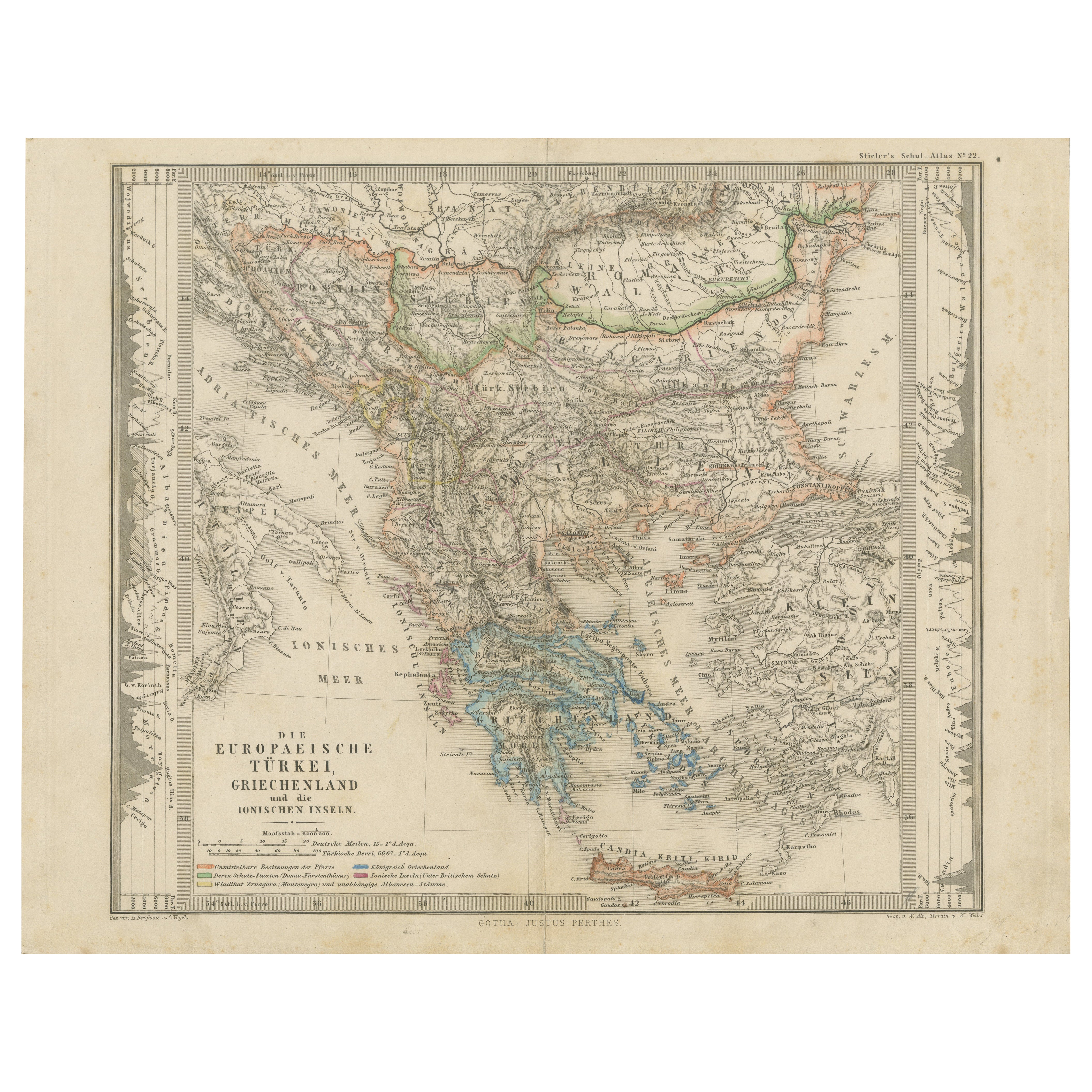
European Turkey and Greece Map – Balkans and Ionian Islands 1857
$408.34
£302.47
€340
CA$558.71
A$607.92
CHF 321.89
MX$7,313.69
NOK 4,087.23
SEK 3,739.53
DKK 2,591.08
About the Item
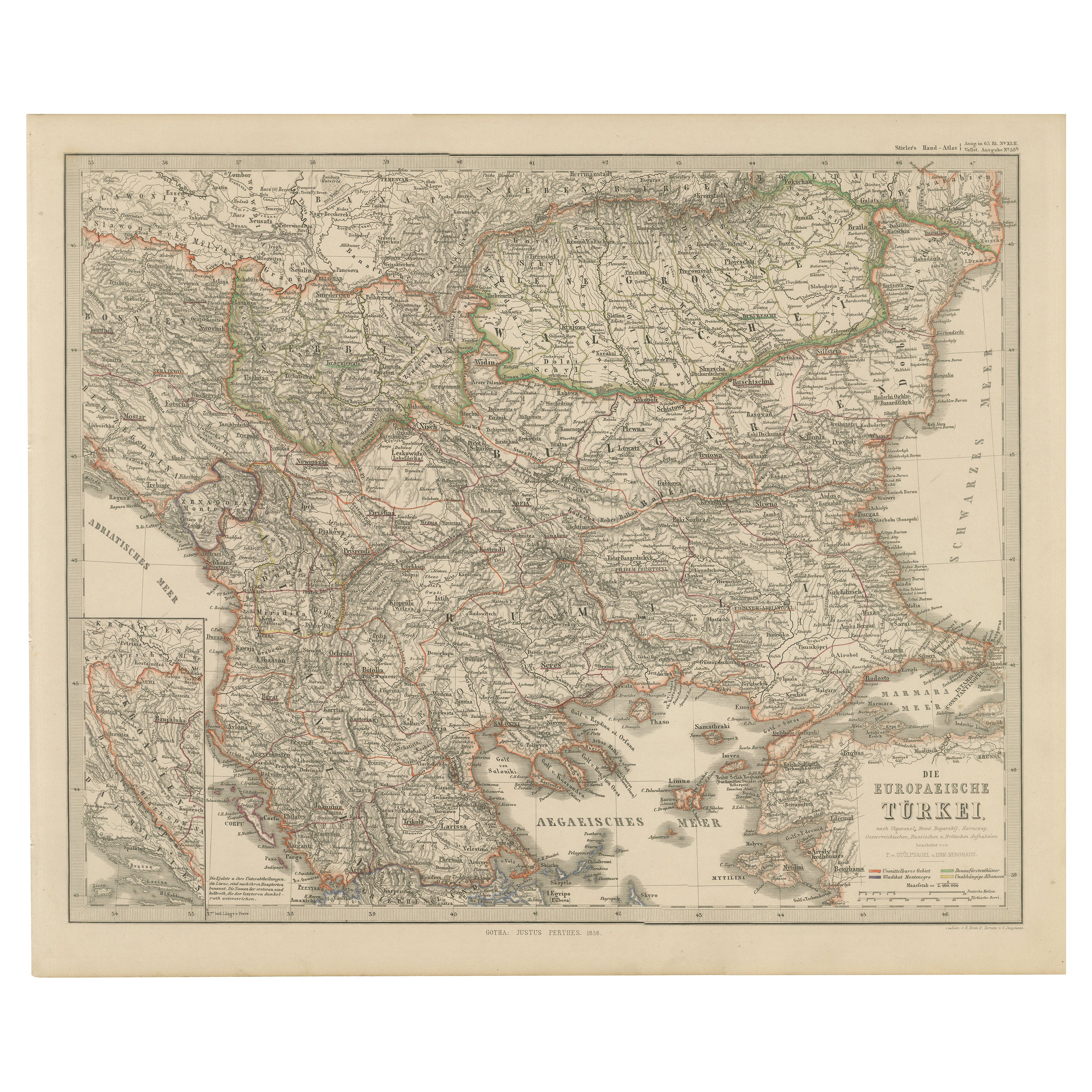
European Turkey and Greece Map – Balkans and Ionian Islands 1857
This detailed antique print shows “Die Europäische Türkei, Griechenland und die Ionischen Inseln” meaning “European Turkey, Greece and the Ionian Islands.” Published in 1857 by Justus Perthes in Gotha as part of Adolf Stieler’s prestigious Hand-Atlas, this map was created under the cartographic direction of F. v. Stülpnagel and H. Berghaus.
The map covers the entire Balkan Peninsula from the Adriatic Sea across to the Black Sea, including present-day Greece, Albania, Macedonia, Bulgaria, Serbia, Bosnia, Croatia, Romania, and European Turkey. It shows the political borders, towns, rivers, and mountain ranges in fine detail, with the Ionian Islands and Crete (Candia) also clearly delineated.
This map is significant as it depicts the Ottoman Empire’s European territories shortly before the major nationalist uprisings and wars of independence that would reshape the region in the late 19th century. Greece is shown as an independent kingdom while neighbouring territories remain under Ottoman control, reflecting the geopolitical tensions of the period.
Technique: Copperplate engraving with original hand colouring, used to differentiate political borders with subtle hues. German titles and annotations are engraved with clarity typical of Stieler’s cartographic standards.
Condition summary: Excellent condition with strong impression, minimal age toning, and no tears, repairs, or significant foxing. Colours remain fresh and paper is firm and stable.
Framing tips: This Balkans and Greece map will look refined in a dark wood or black frame to highlight its historical gravitas, paired with a wide cream or ivory mount to balance its presentation. UV-protective glass is recommended to preserve the engraved detail and original colouring for long-term display.
- Dimensions:Height: 14.77 in (37.5 cm)Width: 17.88 in (45.4 cm)Depth: 0.01 in (0.2 mm)
- Materials and Techniques:Paper,Engraved
- Place of Origin:
- Period:
- Date of Manufacture:1857
- Condition:Condition summary: Excellent condition with strong impression, minimal age toning, and no tears, repairs, or significant foxing. Colours remain fresh and paper is firm and stable.
- Seller Location:Langweer, NL
- Reference Number:Seller: BG-05552-421stDibs: LU3054345812522
About the Seller
5.0
Recognized Seller
These prestigious sellers are industry leaders and represent the highest echelon for item quality and design.
Platinum Seller
Premium sellers with a 4.7+ rating and 24-hour response times
Established in 2009
1stDibs seller since 2017
2,816 sales on 1stDibs
Typical response time: 1 hour
- ShippingRetrieving quote...Shipping from: Langweer, Netherlands
- Return Policy
More From This Seller
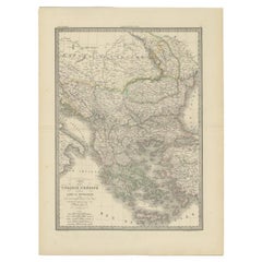
View AllSmall Antique Map of the European Turkey, Greece
Ionian Islands – c.1860
Located in Langweer, NL
Antique Map of the European Turkey, Greece & Ionian Islands – Stieler, c.1860
Original antique map titled *Die Europaeische Türkei, Griechenland und die ...
Category
Antique 1860s Maps
Materials
Paper

Antique Map of Turkey and Greece, 1852
Located in Langweer, NL
Antique map titled 'Europisch Turkije en Griekenland'. Map of Turkey in Europe and Greece. This map originates from 'School-Atlas van alle deelen der Aar...
Category
Antique 19th Century Maps
Materials
Paper

$115 Sale Price
20% Off
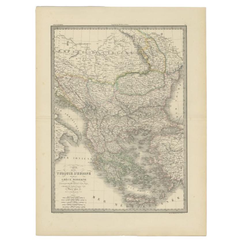
Antique 1842 Map of Turkey and Greece by Pierre M. Lapie, 68x50.5 cm
By Pierre M. Lapie
Located in Langweer, NL
Antique map titled 'Carte de la Turquie d'Europe et de la Grèce Moderne'. Map of Turkey and Greece. This map originates from 'Atlas universel de géographie ancienne et moderne (..)' ...
Category
Antique 19th Century French Maps
Materials
Paper
Balkans
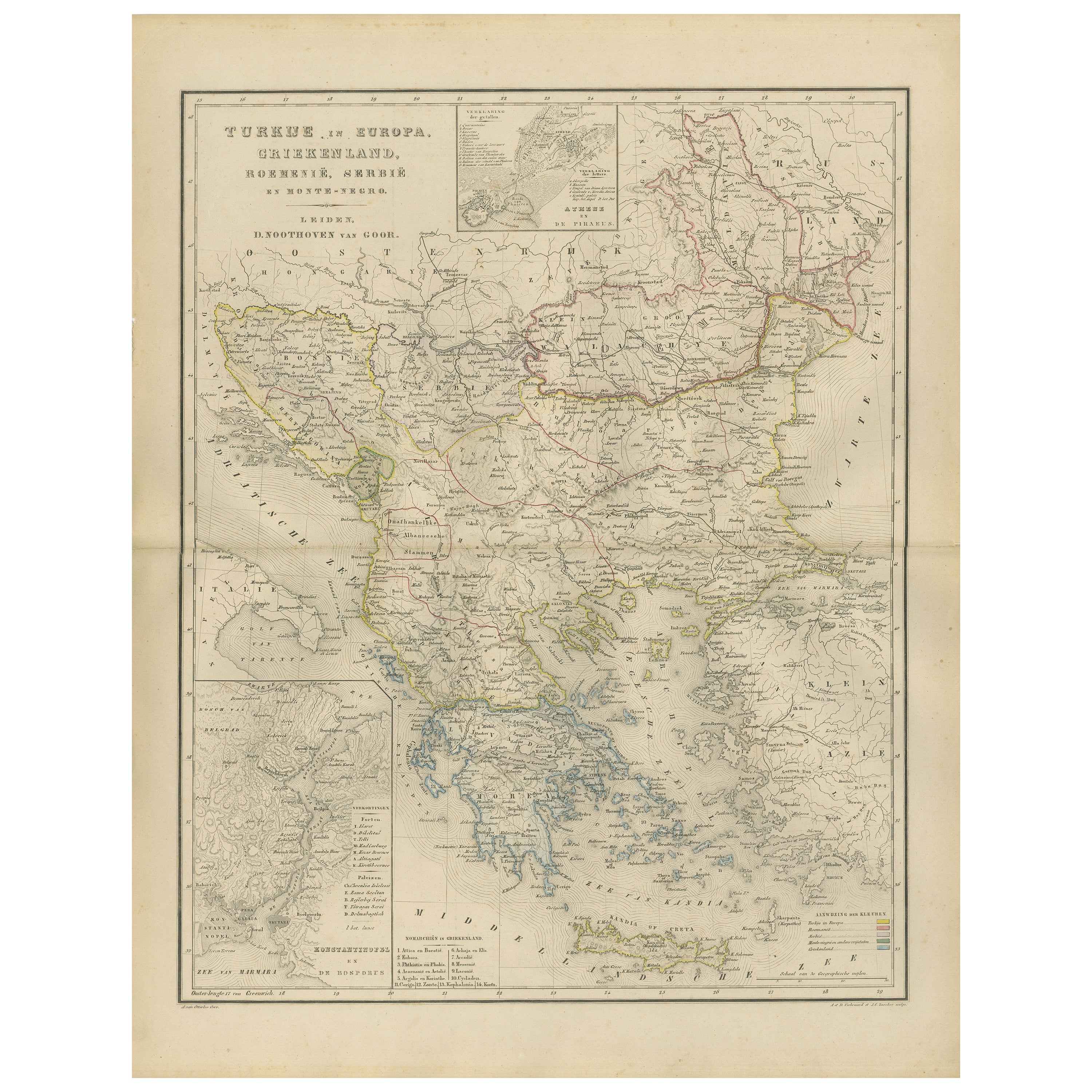
Ottoman Europe Map with Athens Inset – Nieuwe Hand-Atlas, 1876
Located in Langweer, NL
Balkans & Ottoman Europe Map with Athens Inset – Nieuwe Hand-Atlas, 1876
This impressive 19th-century map titled “Turkije in Europa, Griekenland, Roemenië, Servië en Montenegro” provides a richly detailed view of the Balkan Peninsula and the remaining European territories of the Ottoman Empire during a critical historical moment. Published in 1876 in the Nieuwe Hand-Atlas der Aarde in haren Tegenwoordigen Toestand by M. Frijlink, revised by A. van Otterloo and printed by D. Noothoven van Goor in Leiden, this map captures the political and geographical landscape of the Balkans just before the Russo-Turkish War (1877–78) and the subsequent Treaty of Berlin reshaped the region.
The map spans from the Adriatic Sea to the Black Sea, and from the Danube valley down to Crete, covering modern-day Greece, Albania, North Macedonia, Bulgaria, Romania, Serbia, Montenegro, Bosnia and Herzegovina, Thrace, European Turkey, and the Aegean Islands. Hand-colored boundary lines clearly distinguish political units including the Kingdom of Greece, the Principality of Serbia, the United Principalities of Wallachia and Moldavia (Romania), and Ottoman provinces such as Rumelia, Thessaly, Epirus, and Macedonia.
Major cities—Constantinople (Istanbul), Athens, Bucharest, Belgrade, Sofia, Salonika (Thessaloniki), Skodra, Ioannina, Larissa, Adrianople (Edirne), Varna, and Trabzon—are identified with fine engraving work. The map also reflects the complex geography of the region, showing mountain chains such as the Balkans, Pindus, Rhodope, and Dinaric Alps, as well as large river systems including the Danube, Morava, Drina, Vardar, Maritsa, and Iskar.
Inset maps provide valuable additional context: one illustrates the Bosphorus and surrounding fortifications, another focuses on Athens and Piraeus, and a third presents the region around the Gulf of Salonika and Northern Greece. These allow a closer look at strategic locations central to 19th-century European geopolitics.
This plate captures the Balkans at a moment of transition, when national movements were rising and the Ottoman Empire was gradually losing influence. The elegant engraving, refined typography, and harmonious composition are characteristic of Dutch educational cartography at its peak. Today, the map serves as a historical snapshot of a region defined by shifting borders, cultural layers, and emerging nation-states.
Condition Report:
Good condition with gentle toning and scattered small foxing marks, mostly in the margins. Original center fold as issued. Image clean and well-printed with soft, even hand-coloring. No tears, losses, or repairs.
Framing Tips: A light ivory or cream mat works beautifully to highlight the delicate color washes. A slim dark wood or black frame adds contrast and sophistication. Because the map includes attractive insets, a slightly wider mat border enhances balance and readability. Suitable for libraries, studies, travel-themed interiors, and collectors of Ottoman, Greek, and Balkan cartography.
Keywords: Balkans, Ottoman Empire, Turkey in Europe, European Turkey, Greece, Athens, Piraeus, Macedonia, Thrace, Epirus, Thessaly, Crete, Aegean Sea, Bulgaria, Sofia, Varna, Plovdiv, Romania, Bucharest, Wallachia, Moldavia, Danube, Serbia, Belgrade, Montenegro, Cetinje, Albania, Skodra, Ioannina, Thessaloniki, Salonika, Constantinople, Istanbul, Bosphorus, Dardanelles, Adriatic Sea, Aegean Islands, Balkan Peninsula, 19th century Balkans map, 1876 Ottoman map...
Category
Antique 1870s Dutch Maps
Materials
Paper
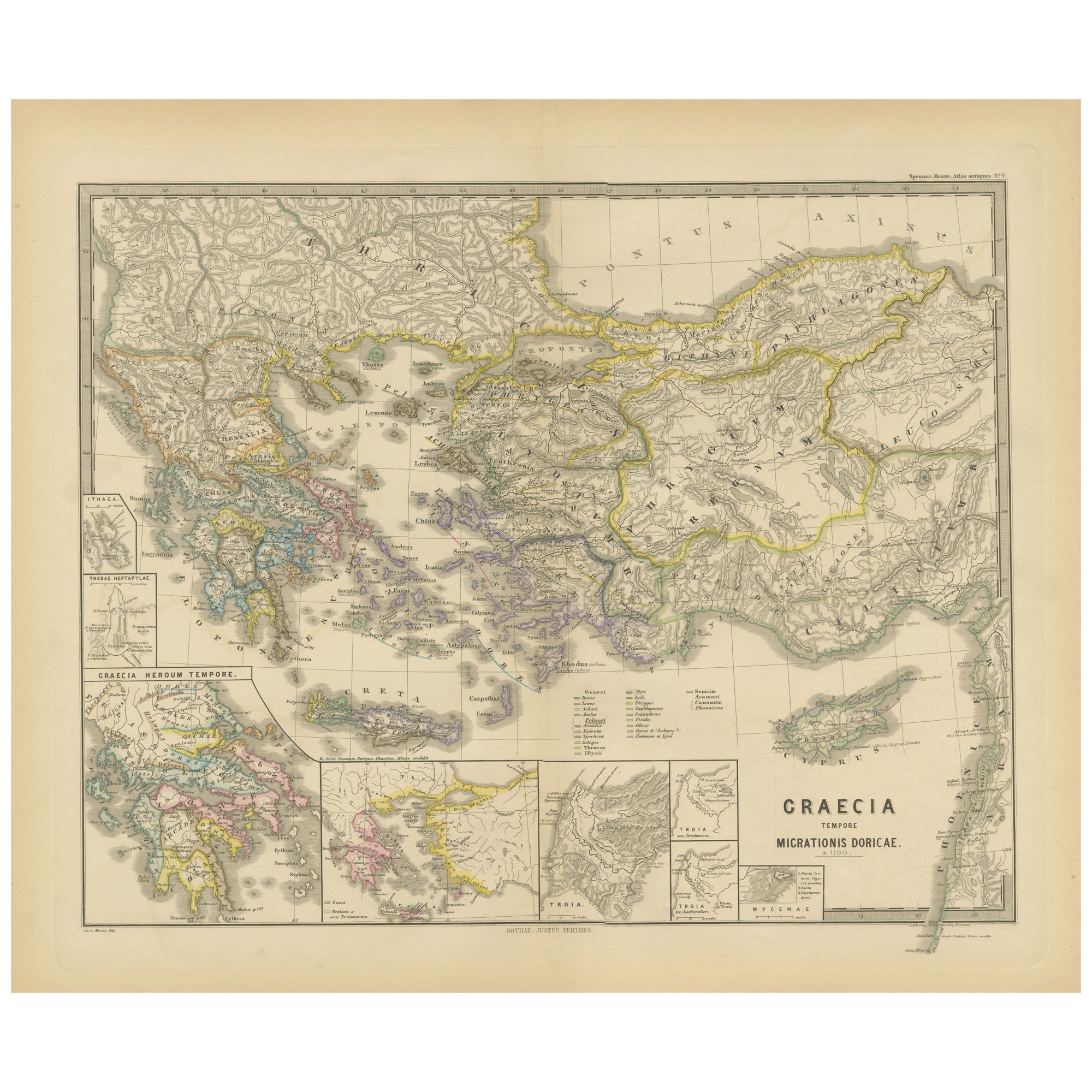
Original Map of Greece at the Time of the Dorian Migration, Published in 1880
Located in Langweer, NL
The map titled "GRAECIA TEMPORI MIGRATIONIS DORICAE," translates to "Greece at the Time of the Dorian Migration." This map showcases the regions of ancient Greece during the period f...
Category
Antique 1880s Maps
Materials
Paper
European Turkey Map – Detailed Balkan Ottoman Provinces 1858
Located in Langweer, NL
European Turkey and Greece Map – Balkans and Ionian Islands 1857
This detailed antique print shows “Die Europäische Türkei, Griechenland und die Ionische...
Category
Antique Mid-19th Century German Maps
Materials
Paper

You May Also Like
Hand-Colored 18th Century Homann Map of the Danube, Italy, Greece, Croatia
By Johann Baptist Homann
Located in Alamo, CA
"Fluviorum in Europa principis Danubii" is a hand colored map of the region about the Danube river created by Johann Baptist Homann (1663-1724) in his 'Atlas Novus Terrarum', publish...
Category
Antique Early 18th Century German Maps
Materials
Paper

Map of Ancient Greece of Macedonia and... - Lithograph by Auguste Wahlen - 1844
Located in Roma, IT
Map of Ancient Greece of Macedonia and Thrace is a lithograph made by Auguste Wahlen in 1844.
Hand colored.
Good condition.
Bottom left is the original title "Carta della Grecia A...
Category
1840s Modern Figurative Prints
Materials
Lithograph

Greece, "Graeciae Antiquae"" A 17th Century Hand-colored Map by Sanson
By Nicolas Sanson
Located in Alamo, CA
This is an original 17th century hand colored copperplate engraved map of Greece entitled "Graeciae Antiquae Tabula Hanc Geographicam" by Nicolas d'Abbeville Sanson, engraved and pub...
Category
Antique Mid-17th Century French Maps
Materials
Paper

$1,260 Sale Price
20% Off
Large Original Antique Map of Cyprus. 1894
Located in St Annes, Lancashire
Superb Antique map of Cyprus
Published Edward Stanford, Charing Cross, London 1894
Original colour
Good condition
Unframed.
Free shipping
Category
Antique 1890s English Maps
Materials
Paper

Large Original Antique Map of The Greek Islands. 1894
Located in St Annes, Lancashire
Superb Antique map of The Greek Islands
Published Edward Stanford, Charing Cross, London 1894
Original colour
Good condition
Unframed.
Free shipping
Category
Antique 1890s English Maps
Materials
Paper

Original Antique Map of Ancient Greece, Achaia, Corinth, 1786
Located in St Annes, Lancashire
Great map of Ancient Greece. Showing the region of Thessaly, including Mount Olympus
Drawn by J.D. Barbie Du Bocage
Copper plate engraving by P.F Tardieu
Original hand color...
Category
Antique 1780s French Other Maps
Materials
Paper

More Ways To Browse
Antique Romanian
Antique Crete
Greek Island Furniture
Beni Ourain Rugs
Glass Top Wood Base Coffee Tables
T Chair
Pair Of Danish Chairs
Veneer Dining Tables
1970 Italian Armchair
Furniture Uk
House Of Denmark Table And Chairs
Louis Marble Top Side Table
Antique Russian Rugs
Baker Furniture By
For Kids
Sterling Silver Flatware Set Service For 12
Tufted Bar
Pair Of French Antique Armchairs