Want more images or videos?
Request additional images or videos from the seller
1 of 19
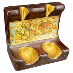
EXTRA LARGE 127CM X 204CM WORLD GLOBE MAP HAND CARVED AND INLAiD IN WOOD
$3,274.32List Price
About the Item
- Dimensions:Height: 50.2 in (127.5 cm)Width: 80.32 in (204 cm)Depth: 0.6 in (1.5 cm)
- Style:Mid-Century Modern (In the Style Of)
- Materials and Techniques:
- Place of Origin:
- Period:
- Date of Manufacture:late 20th century
- Condition:Wear consistent with age and use. Minor fading.
- Seller Location:West Sussex, GB
- Reference Number:1stDibs: LU2823341818662
You May Also Like
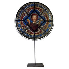
Large (127cm) Stained Colored Glass Window Under Lead, Circa 1880
Located in Honnelles, WHT
Large stained glass window in colored glass, diameter 127cm, Adveniat regnum tuum fortitu dode
Category
Antique Late 19th Century French Napoleon III Religious Items
Materials
Stained Glass
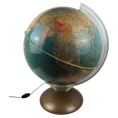
Mid-Century World Map Globe Table Light or Lamp
Located in Miami, FL
Good quality world map globe lamp.
If you are looking for stylish and beautiful quality item to upgrade your interior (whether at home or in your office) then this Parisian globe...
Category
Mid-20th Century French Mid-Century Modern Table Lamps
Materials
Chrome
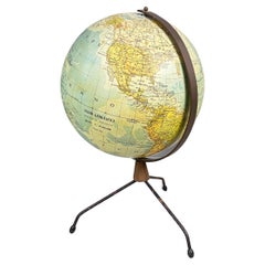
Italian modern Table globe map of the world in metal, 1960s
Located in MIlano, IT
Italian modern Table globe map of the world in metal, 1960s
Table map of the world with metal structure. The globe rotates thanks to the pins of the curved metal structure. The base ...
Category
Vintage 1960s Italian Modern Maps
Materials
Metal
George Philip
s Large Relief Map of the World 150x110cm
By George Philip
Son
Located in Linkebeek, BE
George Philip's Large Relief Map of the World 150x110cm
PHILIP, George Relief Map of the World. George Philip and Son Limited, c. 1950. Large 3D relief map of the world. Shaded relie...
Category
20th Century British Maps
Materials
Plastic, Wood
Italian Mid-Century Modern World Map Globe Pipe Holder Stand
Located in Haddonfield, NJ
Super charming piper holder featuring a world map design and two indentations that hold the bowls of the pipe. Certainly a very functional piece that is elegant enough to sit on a co...
Category
Mid-20th Century Italian Mid-Century Modern Tobacco Accessories
Materials
Ceramic
World Relief Map
Located in Antwerp, BE
Large world relief map.
Measures: Width 232 cm.
Height 158 cm.
Category
Mid-20th Century German Mid-Century Modern Maps
Materials
Acrylic

Two Impressive Huge Midcentury World Map Wall Globes, 95" Diameter, 1950s
Located in Vienna, AT
We proudly offer this outstanding pair of very large wall-mounted modernist globes / world maps with an incredible diameter of 95 inches each. Unique one-of-a-kind sculptures depicti...
Category
Mid-20th Century Austrian Mid-Century Modern Maps
Materials
Aluminum, Iron
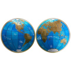
$23,000 / item
H 4 in Dm 95 in
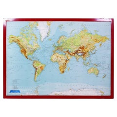
World Map in Mercator’s Projection – Nieuwe Hand-Atlas, Leiden 1876
Located in Langweer, NL
World Map in Mercator’s Projection – Nieuwe Hand-Atlas, Leiden 1876
This 19th-century Dutch world map, titled “Wereld-Kaart in Mercator’s Projectie,” was published in 1876 in the Ni...
Category
Antique 1870s Dutch Maps
Materials
Paper
$278
H 17.33 in W 21.66 in D 0.01 in
Antique Map of the World in 12 Globe Gores by Scherer,
circa 1702
Located in Langweer, NL
Antique map titled 'Typus Totius Orbis Terraquei Geographice Delineatus, Et Ad Usum Globo Materiali Superinducendus'. Beautiful example of Scherer's map of the World, configured in 12 globe gores. California is shown as an island. Fascinating Northwest Passage...
Category
Antique Early 18th Century German Maps
Materials
Paper
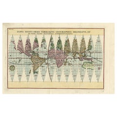
$1,935 Sale Price
20% Off
H 10.63 in W 16.34 in D 0.02 in
20th Century Large Vintage Oval Wall Map of the World Globe Conference Table 13
Located in Dayton, OH
Monumental oval classroom map of the world / wall globe from the second half of the 20th century. A two piece sculpture design made with heavy wood and metal trim paneling. Can be ...
Category
20th Century Maps
Materials
Metal

$2,100 Sale Price
30% Off
H 83 in W 158.5 in D 3 in
More From This Seller
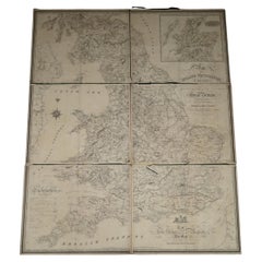
View All1830 DATED EXTRA LARGE 194CM X 159CM INLAND NAViGATION MAP CANALS AND RAILROADS
Located in West Sussex, Pulborough
Royal House Antiques
Royal House Antiques is delighted to offer for sale this Stunning Inland Navigation map of Railroads and Canals by Nichols, Priestley
Walker dated January...
Category
Antique 1830s English Early Victorian Maps
Materials
Maple
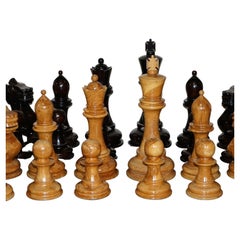
Giant Hand Carved Wood Chess Set Tallest Piece Beautiful Timber Patina
Located in West Sussex, Pulborough
We are delighted to offer for sale this extremely well crafted Giant Chess Set in hand carved hardwood
A truly stunning and exquisitely made set, the whi...
Category
20th Century European Country Games
Materials
Hardwood
Vintage World Map Mirror Based on the Original by Johnson 1882 Military Campaign
Located in West Sussex, Pulborough
We are delighted to offer for sale this lovely Antique style pictorial plan map of the globe based on the original by Johnson in 1882
This is a very interesting and decorative pie...
Category
20th Century English Campaign Maps
Materials
Mirror

Silver Leaf Foil Wall World Map Engraving Based on the Original Moses Pitt, 1681
Located in West Sussex, Pulborough
We are delighted to offer for sale this lovely antique style pictorial silver leaf foil world map taken from and original engraving my Moses Pitt, 1681
This is a very interesting ...
Category
20th Century English Modern Maps
Materials
Silver Leaf

Double Sided and Glazed Cheshire 1645 Hand Colored Antique Print Map Rare Find
Located in West Sussex, Pulborough
We are delighted to offer for sale this lovely antique Atlas page map of Cheshire printed in 1645 Amsterdam Staffordiensis Comitatvs Vulgo
I have thre...
Category
Antique Early 1800s English Georgian Maps
Materials
Paper
Staffordshire 1645 Hand Colored Antique Print Staffordiensis Comitatvs Map
Located in West Sussex, Pulborough
We are delighted to offer for sale this lovely antique Atlas page map of Staffordshire printed in 1645 Amsterdam Staffordiensis Comitatvs Vulgo
This o...
Category
Antique Early 1800s English Georgian Maps
Materials
Paper

More Ways To Browse
Vintage Europe Map
Black Scandinavian Modern Dining Chairs
Gold Modern Coffee Table
Round Glass Coffee Tables
18th Century Wood Side Tables
Antique Hand Carved Dining Room Sets
Mid Century Modern Pitcher
Vintage Italian Leather Dining Chair
Vintage Movie Posters
Blue Green Wool And Silk Rug
Brown Sheepskin Chair
Vintage Brass Bar Carts
Antique Botanical Prints
Green Persian Rug
17th Century Blue And White
50 X 50 Coffee Table
Antique Wood Panel Painted
Milo Baughman 1970
About the Seller
4.7
Platinum Seller
Premium sellers with a 4.7+ rating and 24-hour response times
Established in 2012
1stDibs seller since 2017
2,115 sales on 1stDibs
Typical response time: 1 hour
Authenticity Guarantee
In the unlikely event there’s an issue with an item’s authenticity, contact us within 1 year for a full refund. DetailsMoney-Back Guarantee
If your item is not as described, is damaged in transit, or does not arrive, contact us within 7 days for a full refund. Details24-Hour Cancellation
You have a 24-hour grace period in which to reconsider your purchase, with no questions asked.Vetted Professional Sellers
Our world-class sellers must adhere to strict standards for service and quality, maintaining the integrity of our listings.Price-Match Guarantee
If you find that a seller listed the same item for a lower price elsewhere, we’ll match it.Trusted Global Delivery
Our best-in-class carrier network provides specialized shipping options worldwide, including custom delivery.