1 of 4
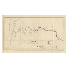
Extremely Large Hand-Drawn Manuscript Map of Surinam, 1830, History of Slavery
$45,634.09List Price
About the Item
- Dimensions:Height: 34.85 in (88.5 cm)Width: 97.05 in (246.5 cm)Depth: 0.08 in (2 mm)
- Materials and Techniques:
- Place of Origin:Suriname
- Period:
- Date of Manufacture:1830
- Condition:Wear consistent with age and use. Can be framed.
- Seller Location:Amsterdam, NL
- Reference Number:1stDibs: LU5458229747452
Authenticity Guarantee
In the unlikely event there’s an issue with an item’s authenticity, contact us within 1 year for a full refund. DetailsMoney-Back Guarantee
If your item is not as described, is damaged in transit, or does not arrive, contact us within 7 days for a full refund. Details24-Hour Cancellation
You have a 24-hour grace period in which to reconsider your purchase, with no questions asked.Vetted Professional Sellers
Our world-class sellers must adhere to strict standards for service and quality, maintaining the integrity of our listings.Price-Match Guarantee
If you find that a seller listed the same item for a lower price elsewhere, we’ll match it.Trusted Global Delivery
Our best-in-class carrier network provides specialized shipping options worldwide, including custom delivery.You May Also Like
Antique Geological Survey Map of Surinam 1888 Hand Colored, Rare
Located in Langweer, NL
Antique Geological Survey Map of Surinam 1888 Hand Colored
This impressive hand-colored geological survey map of Surinam was published in 1888 as part of Karl Martin’s monumental sc...
Category
Antique 1880s German Maps
Materials
Paper
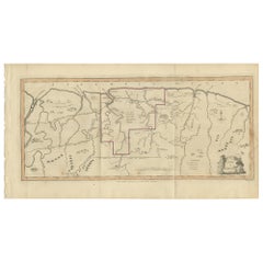
Antique Map of Surinam by Stedman
1813
Located in Langweer, NL
Antique map titled 'A Map of Surinam'. Original antique map of Surinam, showing Dutch settlements, military posts, rebel Maroon camps and native villages. This map originates from 'N...
Category
Antique Early 19th Century Maps
Materials
Paper
Drawn to Greatness: Master Drawings from the Thaw Collection by Pierpont Morgan
Located in valatie, NY
Drawn to Greatness: Master Drawings from the Thaw Collection by Pierpont Morgan Library, Colin B Bailey and Richard R Brettell. Publisher Morgan Librar...
Category
21st Century and Contemporary American Books
Materials
Paper

$150 / item
H 11.75 in W 9.75 in D 1 in
Framed 17th Century Map of Cumberland, England by John Speed, 1610
By John Speed
Located in Middleburg, VA
A fascinating and richly detailed antique map of Cumberland County in northwest England, drawn and published by the celebrated English cartographer John Spe...
Category
Antique Early 17th Century English British Colonial Maps
Materials
Copper, Gold Leaf

Antique Framed Pen and Ink on Fabric Map of Cornwall from Early 19th Century
Located in Los Angeles, CA
This English fabric map of Cornwall, rendered in pen-and-ink, showcases exquisite hand-drawn details and charming faded sepia tones. Encased in a classic frame, this piece elegantly ...
Category
Antique Early 19th Century English Drawings
Materials
Walnut, Fabric

$2,475
H 30.5 in W 44.5 in D 1 in
1815 Spanish Passport Hand Written on Paper
Located in Marbella, ES
1815 Spanish passport hand written on paper. Part of a large collection.
Category
Antique Early 19th Century Spanish Historical Memorabilia
Materials
Paper
1815 Spanish Passport Hand Written on Paper
Located in Marbella, ES
1815 Spanish passport hand written on paper. Part of a large collection.
Category
Antique Early 19th Century Spanish Historical Memorabilia
Materials
Paper
Antique Map of Germany c.1830 by Thomas Kelly – Hand-Coloured Copper Engraving
Located in Langweer, NL
Antique Map of Germany by Thomas Kelly, London, circa 1830, with hand colouring
Finely engraved map of Germany titled 'Germany', published by Thomas Kelly at 17 Paternoster Row, London, circa 1830. This historical map outlines the German states, duchies, and surrounding regions including parts of Austria, Switzerland, France, Poland, and Bohemia. Borders are hand-coloured by region, and major rivers, mountain ranges, and cities such as Berlin, Hamburg, Frankfurt, and Munich are clearly marked. Engraved by H. Cooper.
This beautifully detailed copperplate engraving features original hand colouring and displays the political divisions of early 19th-century Germany, including Prussia, Bavaria, Saxony, and Württemberg, along with neighboring regions such as Austria, Switzerland, Bohemia, and parts of Poland and France. Major cities like Berlin, Munich, Hamburg, and Frankfurt are clearly marked, as well as rivers, mountain ranges, and regional borders. Engraved by H. Cooper.
A fine historical map ideal for collectors, interior decorators, or anyone with an interest in European history or cartography.
Technique and material: Copperplate engraving, original hand colouring
Condition report : Good condition. Strong impression with hand colour. Small chips and edge wear to upper margin, not affecting image. Light age toning and minor handling marks. Tight on the left and right margins.
Framing tip:
Use a neutral or antique white mat to highlight the engraved detail. A dark wood or classic gilt frame complements the historical aesthetic. UV-filtering glass recommended to protect the original colouring.
Keywords for SEO:
antique map, map of Germany, 1830s map, hand-colored map, Thomas Kelly map, old Germany map, Prussia map...
Category
Antique 1830s Maps
Materials
Paper
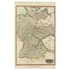
$228
H 16.54 in W 9.85 in D 0.01 in
The Poetry of Light Venetian Drawings, National Gallery of Art, Exhibition Cat
Located in valatie, NY
The Poetry of Light: Venetian Drawings from the National Gallery of Art of Washington: Tiepolo, Canaletto, Sargent, Whistler, by Andrew Robison. Publ...
Category
21st Century and Contemporary Italian Books
Materials
Paper

$125
H 11.5 in W 9.5 in D 1.25 in
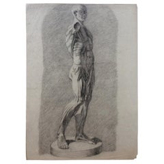
Collection of 4 Antique Anatomical Drawings
Located in Miami, FL
Antique anatomical drawings for the study of the human body, nude males.
The history of anatomy extends from the earliest examinations of...
Category
Antique Late 19th Century French Drawings
Materials
Paper
Still Thinking About These?
All Recently ViewedMore Ways To Browse
Manuscripts
Antique Manuscript
Antique Surveyor
Dutch Military
Tunisia Antique Map
Used Office Furniture Rhode Island
Antique Chesapeake Bay Map
Antique Copper Australia
Antique Furniture Pondicherry
Antique Map Of Cornwall
Antique Maps Dublin
Antique Maps Of Malta
Antique Saudi Arabia
Armenia Map
Cambodia Antique Map
Coronelli Globe
Denoyer Geppert Anatomy
E Fletcher