Items Similar to Framed 1838 Mexico
Gulf of Mexico Map


Want more images or videos?
Request additional images or videos from the seller
1 of 14
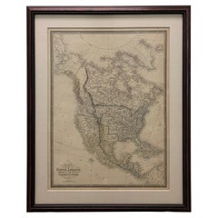
Framed 1838 Mexico
Gulf of Mexico Map
$1,250
£944.86
€1,083.79
CA$1,742.55
A$1,896.91
CHF 1,006.88
MX$22,823.90
NOK 12,758.54
SEK 11,690.43
DKK 8,093.67
About the Item
Framed 1838 Mexico
Gulf of Mexico map. Printed by Fisher, Son
Co. of London in 1838. As found framed condition. Map has not been examined outside of the frame.
- Dimensions:Height: 14 in (35.56 cm)Width: 16 in (40.64 cm)Depth: 1 in (2.54 cm)
- Style:American Classical (In the Style Of)
- Materials and Techniques:
- Place of Origin:
- Period:
- Date of Manufacture:1838
- Condition:Wear consistent with age and use. As found framed condition, light wear to the frame.
- Seller Location:Stamford, CT
- Reference Number:1stDibs: LU1860319809122
About the Seller
5.0
Platinum Seller
Premium sellers with a 4.7+ rating and 24-hour response times
Established in 2010
1stDibs seller since 2016
473 sales on 1stDibs
Typical response time: 9 hours
- ShippingRetrieving quote...Shipping from: Santa Barbara, CA
- Return Policy
More From This Seller
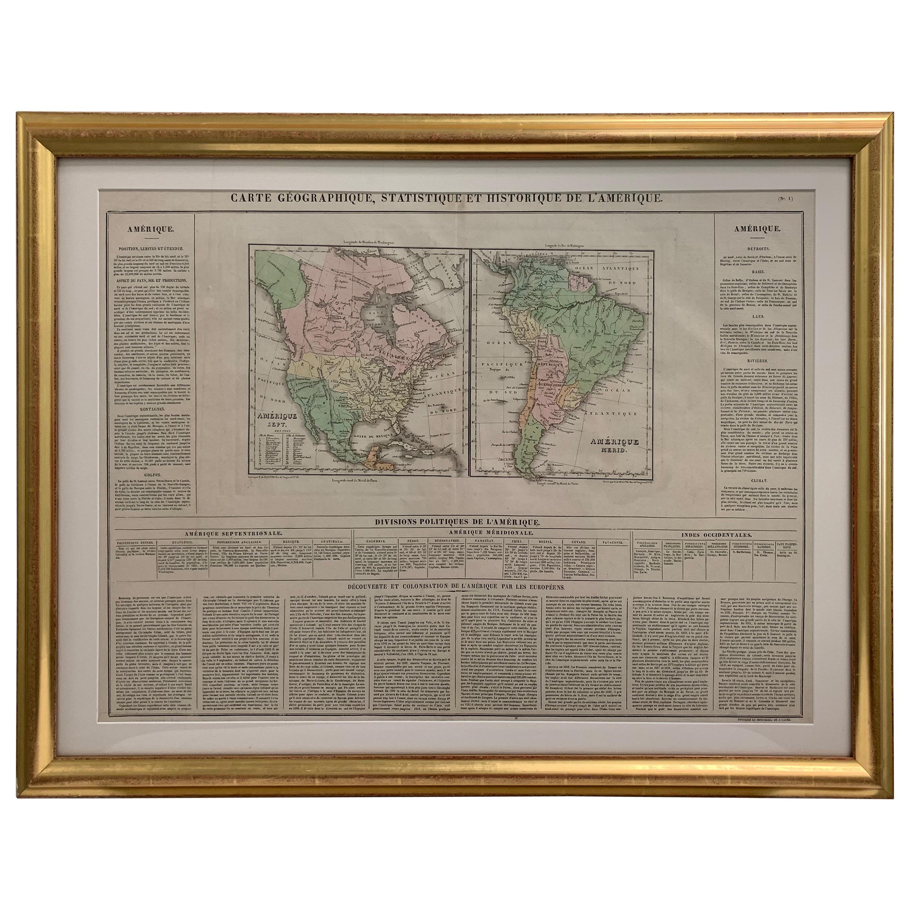
View All1830 Mexico and United States Framed Map
Located in Stamford, CT
Map of North America published circa 1830. Map shows United States into Canada. Mexico extending into the upper California territory. Texas appears in name but prior to the period of...
Category
Antique 1830s American American Classical Maps
Materials
Glass, Wood, Paper

1834 Mexico
Guatemala Framed Map by H.S. Tanner
Located in Stamford, CT
1834 Mexico & Guatemala map of published by H.S. Tanner, Philadelphia, Pennsylvania. Engraved by J. Knight.
As found high end custom framing with carved wood frame, custom matting a...
Category
Antique 1830s American American Classical Maps
Materials
Glass, Wood, Paper

Large 1856 Mexico
Guatemala Framed Map by Charles Desilver
Located in Stamford, CT
Large 1856 Mexico & Guatemala Framed map. Published by Charles Desilver, Philadelphia, Pennsylvania.
As found high end custom framing with black giltwood frame, custom matting and UV...
Category
Antique 1850s American American Classical Maps
Materials
Glass, Wood, Paper
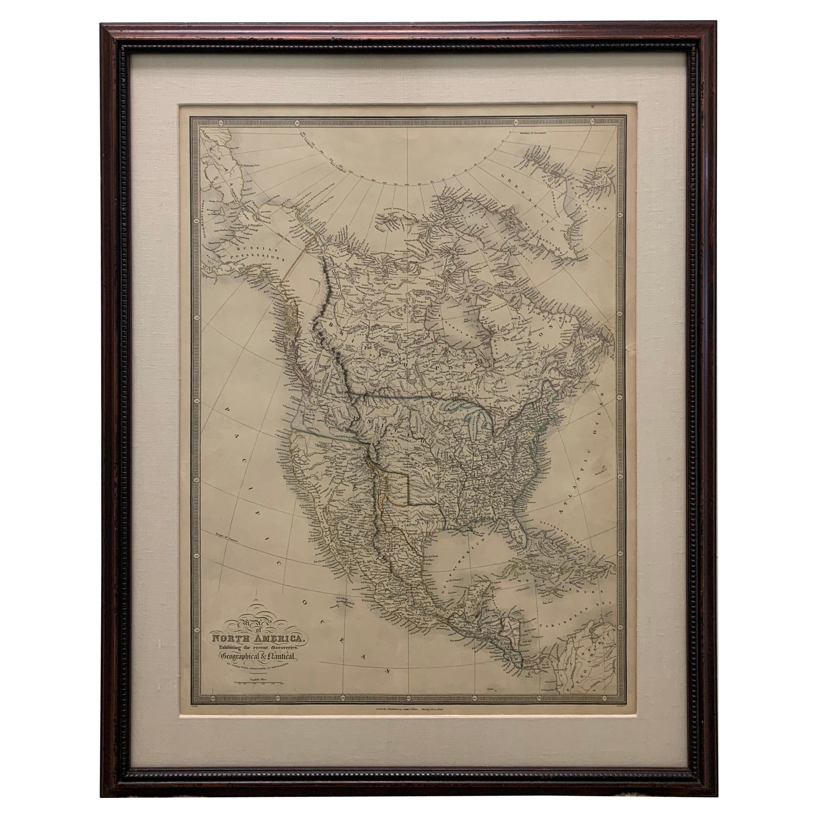
Framed 1838 North America
Recent Discoveries Map
Located in Stamford, CT
1838 map of North America & recent discoveries. Engraved color map by J. Wyld, London, England. This map shows Texas as a Republic without its panhandle.
Framed in brown carved wood...
Category
Antique 1830s American American Classical Maps
Materials
Glass, Wood, Paper
Framed 1820s Hand Colored Map of the United States
Located in Stamford, CT
Framed 1820s hand colored map photos of North America and South America. As found framed in giltwood frame.
Category
Antique 1820s American Spanish Colonial Maps
Materials
Giltwood, Paper, Glass

Framed 1839 Hand Colored Map of the United States
Located in Stamford, CT
Framed hand colored map of the United States of America from 1839. Newly framed in a giltwood frame.
Category
Antique 1830s American American Classical Maps
Materials
Giltwood, Paper, Glass

You May Also Like
1847 Antique Map of Mexico, Texas and California by Samuel Augustus Mitchell
By Samuel Augustus Mitchell 1
Located in Colorado Springs, CO
Presented is the second edition of Samuel Augustus Mitchell's Map of Mexico, Including Yucatan & Upper California, an important map showing the progress of the Mexican-American War. ...
Category
Antique 1840s American Maps
Materials
Paper

South America: Hand-colored 18th Century Framed Map by Thomas Jefferys
By Thomas Jefferys
Located in Alamo, CA
This detailed hand-colored map of South America by Thomas Jefferys was published in London in 1750. The map shows countries, early colonial possessions, towns, rivers, mountains, and...
Category
Antique Mid-18th Century English Maps
Materials
Paper

$460 Sale Price
20% Off
Antique Lithography Map, South America, English, Framed, Cartography, Victorian
Located in Hele, Devon, GB
This is an antique lithography map of South America. An English, framed atlas engraving of cartographic interest by John Rapkin , dating to the early Victorian period and later, circ...
Category
Antique Mid-19th Century British Early Victorian Maps
Materials
Wood

A Hand Colored 18th Century Framed Map of South America by Thomas Jefferys
Located in Alamo, CA
This detailed hand colored map of South America by Thomas Jefferys was published in London in 1750. The map shows countries, early colonial possessions, towns, rivers, mountains, and...
Category
Mid-18th Century Other Art Style Landscape Prints
Materials
Engraving

1847 Ornamental Map of the United States
Mexico by H. Phelps
Located in Colorado Springs, CO
Offered is an original 1847 ornamental map of the U.S. entitled "Ornamental Map of the United States
Mexico" by Humphrey Phelps. The map was issued as an act of Congress by Phelps on Fulton Street, New York. The broadside is elaborately hand-colored.
This is a very detailed and graphic propaganda map of the United States expressing U.S. dominance of the North American continent. The hand-colored map proclaims the Manifest Destiny, with the recent acquisition of Upper California and Texas at the conclusion of the Mexican-American War. The newly acquired land is boldly colored, standing in stark contrast to the rest of the U.S. The map details a potential route for a railroad running from New York City, to Buffalo, to Chicago, then west along the Oregon Trail to Oregon City. This route anticipates the construction of the transcontinental railroad by nearly 20 years.
The map includes elaborately detailed renderings of George Washington, Hernan Cortez, and Montezuma at top to represent European expansion to the Americas. At bottom are four inset designs with text showing the following: a chronological history of the U.S. beginning from settlement to the U.S. victory in the Mexican-American war; an illustration of General Zachary Taylor with details on the Oregon Territory; an illustration of the Aztec Temple of the Sun in Tenochtitlan and a chronology of the Conquest of the Aztec Empire under Cortez; a portrait of General Antonio Lopez de Santa Anna...
Category
Antique 1840s American Maps
Materials
Paper

Antique Map of South America in Roma Frame
Located in Malibu, CA
Antique map of South America. Displayed in a new Roma frame with museum quality matting. Custom frame in platinum. No print date, but cert...
Category
Antique Late 19th Century Victorian Prints
Materials
Hardwood, Paper

$262 Sale Price
30% Off
More Ways To Browse
Antique Mexican Furniture
Mexican Wood Frame
Antique Map Mexico
Antique Maps Scotland
Furniture Russian 18th Century
Antique Map Of Middle East
London Antique Maps
Map Colorful
Maps Of Australia
Antique Railroad Furniture
Map Of London
Antique Galleon
Antique Maps Australia
Used Nautical Charts
Antique Collectables Australia
Joan Blaeu
Map Greece
Antique Maps Of New York City