Want more images or videos?
Request additional images or videos from the seller
1 of 7
Framed Rand McNally Political Wall Map by J. Paul Goode
$8,800List Price
About the Item
- Dimensions:Height: 48 in (121.92 cm)Width: 68 in (172.72 cm)Depth: 2.75 in (6.99 cm)
- Materials and Techniques:
- Place of Origin:
- Period:
- Date of Manufacture:20th Century
- Condition:
- Seller Location:New York City, NY
- Reference Number:Seller: ACC09531stDibs: 1210239165182
About the Seller
5.0
Vetted Professional Seller
Every seller passes strict standards for authenticity and reliability
Established in 1995
1stDibs seller since 2011
109 sales on 1stDibs
Typical response time: 2 hours
Authenticity Guarantee
In the unlikely event there’s an issue with an item’s authenticity, contact us within 1 year for a full refund. DetailsMoney-Back Guarantee
If your item is not as described, is damaged in transit, or does not arrive, contact us within 7 days for a full refund. Details24-Hour Cancellation
You have a 24-hour grace period in which to reconsider your purchase, with no questions asked.Vetted Professional Sellers
Our world-class sellers must adhere to strict standards for service and quality, maintaining the integrity of our listings.Price-Match Guarantee
If you find that a seller listed the same item for a lower price elsewhere, we’ll match it.Trusted Global Delivery
Our best-in-class carrier network provides specialized shipping options worldwide, including custom delivery.You May Also Like
Large Original Antique Map of Arkansas by Rand McNally, circa 1900
By Rand McNally
Co.
Located in St Annes, Lancashire
Fabulous monochrome map with red outline color
Original color
By Rand, McNally & Co.
Published, circa 1900
Unframed
Minor edge tears.
Category
Antique Early 1900s American Edwardian Maps
Materials
Paper

$90
Free Shipping
H 20.5 in W 27.5 in D 0.07 in
Original Antique Map of South Dakota by Rand McNally, circa 1900
By Rand McNally
Co.
Located in St Annes, Lancashire
Fabulous monochrome map with red outline color
Original color
By Rand, McNally & Co.
Published, circa 1900
Unframed
Minor edge tears.
Category
Antique Early 1900s American Edwardian Maps
Materials
Paper

$90
Free Shipping
H 14 in W 20.5 in D 0.07 in
Antique Railroad Map of the United States by Rand, McNally
Co, 1900
Located in Langweer, NL
Antique map titled 'Rand, McNally & Co's New Official Railroad map of the United States with portions of The Dominion of Canada, The Republic of Mexico and the West Indies'. Large railroad map of the United States, sectionalised and laid on linen. Map shows state boundaries for the United States, Mexico, the West Indies, and lower portion of Canada; major cities and towns, military posts, Native American reservations, and railroads; Oklahoma and "Indian Territory." Inset: "Map of Alaska...
Category
20th Century Maps
Materials
Linen, Paper

$2,245 Sale Price
25% Off
Free Shipping
H 30.91 in W 43.9 in D 0.02 in
Matthaus Seutter, Framed 1730 Color Engraving Map of "Belgium Fonderatum"
Located in Bridgeport, CT
Label on verso. From Grosser Atlas. The name Belgium comes from the ancient designation "Gallis Belgica". Figural decoration upper left. M. Seutter was a famed German mapmaker in the...
Category
Antique 18th Century European Renaissance Maps
Materials
Brass

$1,400
H 27.5 in W 31 in D 0.75 in
Antique Map of Korea by Kozaki, 1903
Located in Langweer, NL
Old map of Korea by S. Kozaki. Restored and mounted.
Category
20th Century Maps
Materials
Paper

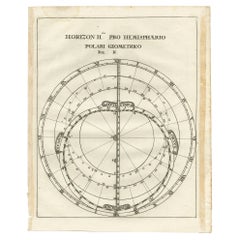
Antique Map of a Hemisphere by Scherer, c.1703
Located in Langweer, NL
Antique map depiciting a horizon/hemisphere. Printed for Scherer's 'Atlas Novus' (1702-1710).
Artists and Engravers: Heinrich Scherer (1628-1704) was a Professor of Hebrew, Mathematics and Ethics at the University of Dillingen until about 1680. Thereafter he obtained important positions as Official Tutor to the Royal Princes...
Category
Antique 18th Century Maps
Materials
Paper
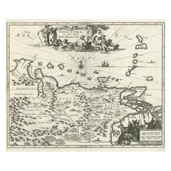
Antique Map of Venezuela by Montanus, 1671
By Arnoldus Montanus
Located in Langweer, NL
Antique map titled 'Venezuela cum parte Australi Novae Andalusiae'. The map extends from Coquibocoa to the Orinoque River, centered on Bariquicemento and Cape de Curiacao. Large cart...
Category
Antique Mid-17th Century English Maps
Materials
Paper
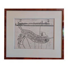
Antique City View and Map of IJlst, City in Friesland, Holland, Framed, 1664
Located in Langweer, NL
Antique map titled 'Ylst'. Old map and city view of the city of IJlst, Friesland. This map originates from 'Beschrijvinge van de Heerlyckheydt van Frieslandt' by B. Schotanus à Sterr...
Category
Antique 17th Century Maps
Materials
Paper
$598
H 21.78 in W 18.59 in D 0 in
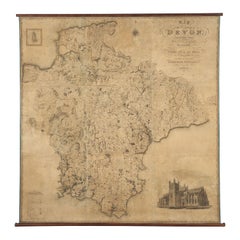
Map Hanging Wall County of Devon C&J Greenwood 1827 Exeter Cathedral Lundy Isle
Located in BUNGAY, SUFFOLK
C & J GREENWOOD MAP OF THE COUNTY OF DEVON, FROM AN ORIGINAL SURVEY, PUBLISHED 1827, WITH ENGRAVING OF EXETER CATHEDRAL AND MAP OF LUNDY INSET, 6ft 2 ...
Category
Antique 1820s English Early Victorian Maps
Materials
Paper
$13,640
H 76.23 in W 74.26 in D 0.4 in
World Relief Map
Located in Antwerp, BE
Large world relief map.
Measures: Width 232 cm.
Height 158 cm.
Category
Mid-20th Century German Mid-Century Modern Maps
Materials
Acrylic

More From This Seller
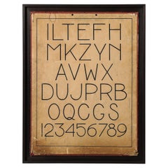
View AllArtwork with Custom Mahogany Frame, United States, c. 1950
Located in New York City, NY
Framed Boston Public School Letter chart. This was custom framed by our trusted fine art framer, with a high-quality stained mahogany frame.
Category
Vintage 1950s American Decorative Art
Materials
Mahogany
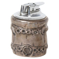
Sterling Silver "Bamboo" Lighter by Hermès, France, c. 1950s
By Hermès
Located in New York City, NY
Vintage "bamboo" Lighter in Sterling Silver by Hermès, France, c. 1950s
Engraved on the underside with maker's name.
Category
Vintage 1950s French Mid-Century Modern Tobacco Accessories
Materials
Sterling Silver
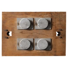
Vintage Industrial Component on Board, United States, 20th C
Located in New York City, NY
Vintage industrial parts mounted to an aged pine board. Cool, modernist effect.
Category
20th Century American Industrial Decorative Art
Materials
Metal
Silver and Brass Lighter, Hermes, Italy, c. 1970
By Hermès
Located in New York City, NY
This vintage Hermes lighter is meticulously crafted in brass and silver and adorned with the iconic Hermes logo.
Category
Vintage 1970s Italian Modern Tobacco Accessories
Materials
Sterling Silver, Brass
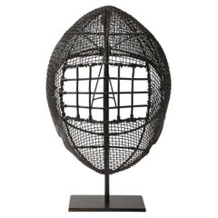
Antique Patinated Wire Mesh Fencing Mask on Stand
Located in New York City, NY
Antique Patinated Wire Mesh Fencing Mask on Stand
Category
20th Century Sports Equipment and Memorabilia
Materials
Wire
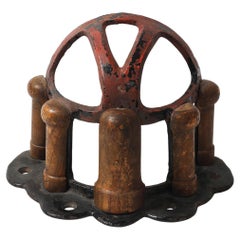
Antique Fruitwood and Cast Iron Saddle Rack, England, 19th C
Located in New York City, NY
Antique Fruitwood and Cast Iron Saddle Rack by Musgraves of Belfast, England, 19th C
Could be utilized as tabletop decor or hung upside down as a basket
Category
Antique 19th Century English Sports Equipment and Memorabilia
Materials
Iron
Still Thinking About These?
All Recently ViewedMore Ways To Browse
Antique Russian Rugs
For Kids
Sterling Silver Flatware Set Service For 12
Tufted Bar
Pair Of French Antique Armchairs
1970s Brass Glass Coffee Table
Charles Rennie Mackintosh For Cassina
Glass Salt
Italian Modern Silver Vases
Vintage Resin Tables
Antique English Country Furniture
Blue Kilim Vintage
Contemporary Side Tables And Stools
Decorative Wall Plate
Mid Century Modern Corner Chair
Dining Tables With Brass Inlay
Oak Mid Century Armchair
Solid Wood Side Table Stool