Items Similar to French Edition of an Antique Map of Friesland in the Netherlands, 1709


Video Loading
Want more images or videos?
Request additional images or videos from the seller
1 of 11
French Edition of an Antique Map of Friesland in the Netherlands, 1709
$624.47
$780.5820% Off
£462.51
£578.1420% Off
€520
€65020% Off
CA$854.24
CA$1,067.8020% Off
A$929.67
A$1,162.0920% Off
CHF 492.82
CHF 616.0220% Off
MX$11,184.69
MX$13,980.8720% Off
NOK 6,250.54
NOK 7,813.1720% Off
SEK 5,718.80
SEK 7,148.5020% Off
DKK 3,962.49
DKK 4,953.1120% Off
About the Item
Antique Map of Friesland – “La Seigneurie d’Ouest-Frise ou Frise Occidentale” by Jaillot, 1709
This elegant and detailed map, titled “La Seigneurie d’Ouest-Frise ou Frise Occidentale,” presents the province of Friesland in the Netherlands during the early 18th century. Published in 1709 by the celebrated French cartographer Alexis-Hubert Jaillot, the map captures the region’s intricate network of waterways, reclaimed polders, and coastal islands, set within richly engraved borders.
Drawn in Jaillot’s refined style, the map features finely shaded relief and carefully coloured boundaries delineating towns, villages, and administrative divisions. Coastal details include the Frisian Islands, the Zuyder Zee (now IJsselmeer), and the Wadden Sea, with their tidal flats and sandbanks meticulously rendered. Place names are given in French, reflecting the map’s intended audience among the educated European elite.
Two decorative cartouches enhance the composition: the upper right contains a scale bar framed by ornamental motifs, while the lower right cartouche displays the title with elaborate scrollwork and floral embellishments in full hand colour. The map not only served as a geographic record but also as a testament to Friesland’s identity within the Dutch Republic, during a period when the Netherlands was at the height of its maritime and economic power.
Alexis-Hubert Jaillot (1632–1712) was one of the most important French cartographers of the late 17th and early 18th centuries, known for his collaboration with the Sanson family and for producing large-format, highly decorative maps for atlases aimed at a wealthy and scholarly clientele.
Condition: Very good for age. Light toning to margins, minor spotting, and original centre fold as issued. Strong impression with attractive later hand-colouring.
Framing tips: A gilt or dark walnut frame with a cream archival mat will enhance both the delicate colouring and the ornate cartouches, making the map a striking display piece.
Technique: Hand-coloured copper engraving
Maker: Alexis-Hubert Jaillot, Paris, 1709
- Dimensions:Height: 22.25 in (56.5 cm)Width: 27.17 in (69 cm)Depth: 0 in (0.01 mm)
- Materials and Techniques:Paper,Engraved
- Place of Origin:
- Period:
- Date of Manufacture:1709
- Condition:Condition: Very good for age. Light toning to margins, minor spotting, and original centre fold as issued. Strong impression with attractive later hand-colouring.
- Seller Location:Langweer, NL
- Reference Number:Seller: BG-002651stDibs: LU3054326282112
About the Seller
5.0
Recognized Seller
These prestigious sellers are industry leaders and represent the highest echelon for item quality and design.
Platinum Seller
Premium sellers with a 4.7+ rating and 24-hour response times
Established in 2009
1stDibs seller since 2017
2,816 sales on 1stDibs
Typical response time: 1 hour
- ShippingRetrieving quote...Shipping from: Langweer, Netherlands
- Return Policy
More From This Seller
View AllAntique Map of Friesland in the Netherlands, 1770
Located in Langweer, NL
Antique map titled 'De Synode van Friesland, in VI Klassen verdeeld door W.A. Bachiene?. Map of the province of Friesland, the Netherlands. This map originates from 'Nieuwe kerkelyke...
Category
Antique 18th Century Maps
Materials
Paper

Antique Map of Friesland, A Dutch Province, c.1780
Located in Langweer, NL
Antique map titled 'Dominii Frisiae (..)'. Original antique map of Friesland. 3rd state, most likely published after 1775 (De Rijke, 46.3). Artists and Engravers: Published by P. Sch...
Category
Antique 18th Century Maps
Materials
Paper

Antique Map of the Province of Friesland in The Netherlands, 1718
Located in Langweer, NL
Antique map titled 'Frisiae Dominium vernacule Friesland (..)'.
Original antique map of Friesland, the Netherlands. Originates from 'Uitbeelding van de Heerlijkheid van Friesland...
Category
Antique 18th Century Maps
Materials
Paper

Antique Map of the Province Groningen in The Netherlands, c.1680
Located in Langweer, NL
Antique map titled 'Groningae et Omlandiae Dominium vulgo de Provincie van Stadt en Lande'.
Old map of the province of Groningen, the Netherlands. This map originates from 'Germani...
Category
Antique 17th Century Maps
Materials
Paper

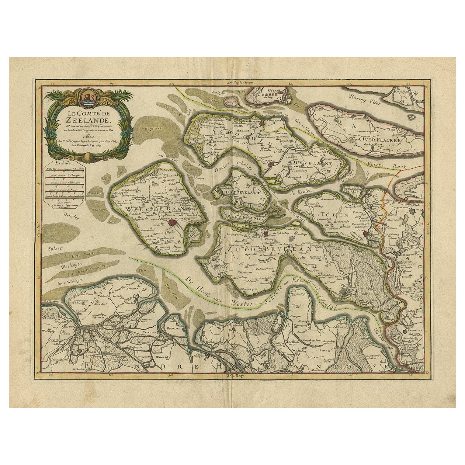
Antique Map of Zeeland, The Netherlands, by Jaillot, 1693
Located in Langweer, NL
Antique map titled 'Le Comte de Zeelande (..).' Detailed map of the province of Zeeland, The Netherlands. Details shown include fortified towns, roads, sandbanks and marshlands. Base...
Category
Antique 17th Century Maps
Materials
Paper

$855 Sale Price
20% Off
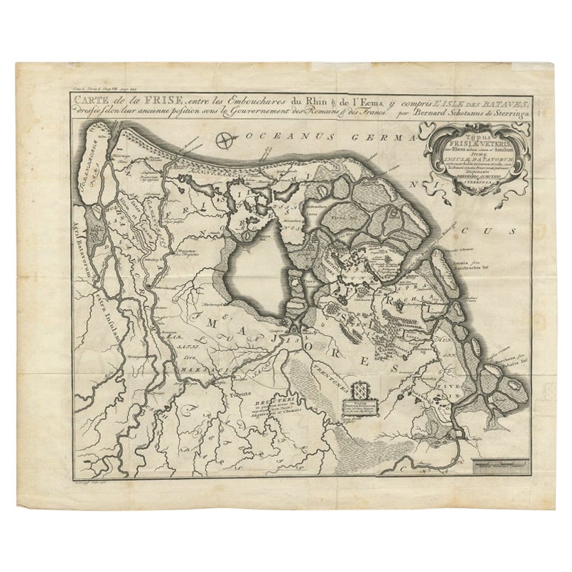
Rare Antique Map of Friesland in Roman Times, Published 1778
Located in Langweer, NL
Antique map titled 'Carte de la Frise, entre les Embouchures du Rhin & de l'Eems, ij compris l'isle Bataves, dressée selon leur ancienne position le Gouvernement des Romains & des Fr...
Category
Antique 18th Century Maps
Materials
Paper
You May Also Like
1752 Vaugoundy Map of Flanders : Belgium, France, and the Netherlands, Ric.a002
Located in Norton, MA
Large Vaugoundy Map of Flanders:
Belgium, France, and the Netherlands
Colored -1752
Ric.a002
Description: This is a 1752 Didier Robert de Vaugondy map of Flanders. The map de...
Category
Antique 17th Century Unknown Maps
Materials
Paper

1643 Willem&Joan Blaeu Map NW Flanders "Flandriae Teutonicae Pars Prientalior
Located in Norton, MA
1643 Willem and Joan Blaeu map of northwest Flanders, entitled
"Flandriae Teutonicae Pars Prientalior,"
Ric0012
" Authentic" - Map of the northwest Fl...
Category
Antique 17th Century Dutch Maps
Materials
Paper

1635 Willem Blaeu Map of Northern France"Comitatvs Bellovacvm" Ric.a08
Located in Norton, MA
1635 Willem Blaeu map of northern France, entitled.
"Comitatvs Bellovacvm Vernacule Beavvais,"
Colored
Ric.a008
“COMITATVS BELLOVACVM…” Amsterdam: W...
Category
Antique 17th Century Unknown Maps
Materials
Paper

1657 Janssonius Map of Vermandois and Cappelle, Ric. A-004
Located in Norton, MA
1657 Janssonius map of
Vermandois and Cappelle
Ric.a004
Description: Antique map of France titled 'Descriptio Veromanduorum - Gouvernement de la Cappelle'. Two detailed maps o...
Category
Antique 17th Century Unknown Maps
Materials
Paper

1633 Map "La Souverainete De Sedan Et De Raucourt, Et La Prevoste Ric0011
Located in Norton, MA
1653 map entitled
"La Souverainete de Sedan et de Raucourt, et la Prevoste de Doncheri,"
Ric0011
Description:
Lovely map centered on Sedan and Doncheri and the Meuze River fr...
Category
Antique 17th Century Dutch Maps
Materials
Paper

1640 Joan Bleau Map Entitled"Diocecese de rheims et le pais de rethel, " Eic.a011
Located in Norton, MA
1640 Joan Bleau map entitled
"Diocecese de rheims et le pais de rethel,"
Ric.a011
OAN BLAEU
Diocecese de Rheims, et le pais de Rethel.
Handcolored engraving, c.1640.
...
Category
Antique 17th Century Dutch Maps
Materials
Paper

More Ways To Browse
Maps Balkans
Antique Map Of Jerusalem
Map Of Corsica
Solomons Temple
Antique Map Of Korea
Map Of Jerusalem
Prussia Map
Antique Maps Caribbean Islands
Antique Wine Maps
Used Furniture Wisconsin
Antique Furniture Michigan
Antique Maps Of Cape Of Good Hope
Antique Maps Of Texas
Antique Virginia Furniture
Otto Petri
American West Antiques
Antique Furniture Brunswick
Antique Map Ceylon