1 of 10
French School Map of United Kingdom
$350List Price
About the Item
Authenticity Guarantee
In the unlikely event there’s an issue with an item’s authenticity, contact us within 1 year for a full refund. DetailsMoney-Back Guarantee
If your item is not as described, is damaged in transit, or does not arrive, contact us within 7 days for a full refund. Details24-Hour Cancellation
You have a 24-hour grace period in which to reconsider your purchase, with no questions asked.Vetted Professional Sellers
Our world-class sellers must adhere to strict standards for service and quality, maintaining the integrity of our listings.Price-Match Guarantee
If you find that a seller listed the same item for a lower price elsewhere, we’ll match it.Trusted Global Delivery
Our best-in-class carrier network provides specialized shipping options worldwide, including custom delivery.You May Also Like
Original Antique Map of the United Kingdom and Ireland, Published in 1875
Located in Langweer, NL
Antique map titled 'Iles Britanniques ou Royaume-Uni de la Grande Bretagne (..)'. Large map of the United Kingdom and Ireland. This map originates from...
Category
Antique Late 19th Century French Maps
Materials
Paper

$294 Sale Price
30% Off
H 24.02 in W 18.71 in D 0.02 in
Antique Map of the Kingdom of France by Keizer
de Lat, 1788
Located in Langweer, NL
Antique map titled 'Kaart van 't Koninkryk van Vranckryk'. Uncommon original antique map of the Kingdom of France. This map originates from 'Nieuwe Natuur- Geschied- en Handelkundige...
Category
Antique Late 18th Century Maps
Materials
Paper
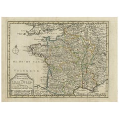
$336 Sale Price
20% Off
H 8.08 in W 10.83 in D 0.02 in
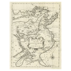
Antique Map of the Kingdom of Tunisia, Africa, 1773
Located in Langweer, NL
Antique map titled 'Kaart van het Koningryk van Tunis'. Old map of the Kingdom of Tunisia. Originates from the first Dutch editon of an interesting travel account of Northern Africa ...
Category
Antique 18th Century Maps
Materials
Paper
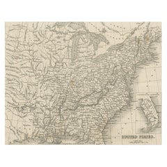
Antique Map of the Eastern United States with Inset Map of Texas
Located in Langweer, NL
Antique map titled 'Verein-Staaten von Nord-America mit Ausnahme Florida's und der Westlichen Territorien'. This map extends as far west as Louisiana and only includes the northern p...
Category
Antique Mid-19th Century Maps
Materials
Paper

$518 Sale Price
20% Off
H 14.65 in W 17.84 in D 0.02 in
Steel Engraved Map of the United States with Inset Map of Florida
Located in Langweer, NL
Antique map titled 'United States'. Steel engraved map of the United States. With small inset map of the continuation of Florida. Source unknown, to be determined. Published circa 1843.
Category
Antique Mid-19th Century Maps
Materials
Paper
$153 Sale Price
20% Off
H 8.15 in W 10.44 in D 0.02 in
Antique Map of the Kingdom of Denmark by Wyld
1845
Located in Langweer, NL
Antique map titled 'Kingdom of Denmark'. Original antique map of the Kingdom of Denmark. This map originates from 'An Atlas of the World, Comprehending Separate Maps of its Various C...
Category
Antique Mid-19th Century Maps
Materials
Paper
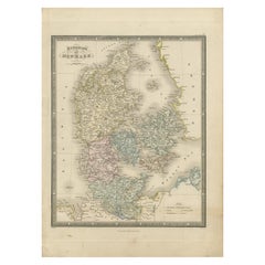
$156 Sale Price
35% Off
H 14.18 in W 10.24 in D 0.02 in
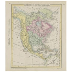
Small Map of the United States, circa 1870
Located in Langweer, NL
Antique map titled 'Amérique septe. Physique'. Small map of the United States. lithographed by C. Callewaert brothers in Brussels circa 1870.
Category
Antique Mid-19th Century Belgian Maps
Materials
Paper
Antique Map of the Southern United States with Inset Map of New Orleans
Located in Langweer, NL
Antique map titled 'Die Staaten von Arkansas Mississippi, Louisiana & Alabama'. Detailed map of the region, which includes the Florida Panhandle. Shows many roads, rivers, forts, etc...
Category
Antique Mid-19th Century Maps
Materials
Paper
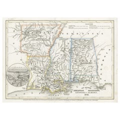
$134 Sale Price
20% Off
H 9.06 in W 12.21 in D 0.02 in
Antique Print of Designs for Ebberston Lodge, Yorkshire, United Kingdom, 1725
Located in Langweer, NL
Antique print titled 'The Elevation of Ebberston Lodge (..)'. Designs for Ebberston Lodge, near Scarborough, Yorkshire, England.
This print originates from 'Vitruvius Britannicus' ...
Category
Antique 18th Century Prints
Materials
Paper
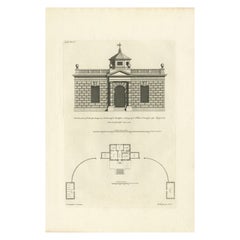
$528
H 19.89 in W 13.78 in D 0 in
Antique Map of the United States with inset map of the region of Mexico City
Located in Langweer, NL
Antique map titled 'Verein-Staaten von Nord-America, Mexico, Yucatan u.a.'. Very detailed map of the United States of America showing the Caribbean. With an inset map of the surround...
Category
Antique Mid-19th Century Maps
Materials
Paper

$826 Sale Price
20% Off
H 14.69 in W 17.92 in D 0.02 in