Want more images or videos?
Request additional images or videos from the seller
1 of 13
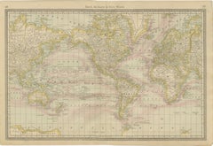
Frontgate Rand McNally World Classic Magnetic Travel Map with Burlwood Frame
$700List Price
About the Item
- Dimensions:Height: 36 in (91.44 cm)Width: 53 in (134.62 cm)Depth: 1 in (2.54 cm)
- Style:Modern (In the Style Of)
- Materials and Techniques:Burl,Paper
- Period:
- Date of Manufacture:Late 20th Century
- Condition:Wear consistent with age and use. Very Good; Gently Used (Does not include Magnets).
- Seller Location:Dayton, OH
- Reference Number:Seller: 366751stDibs: LU5343233321402

About the Seller
5.0
Platinum Seller
Premium sellers with a 4.7+ rating and 24-hour response times
Established in 2010
1stDibs seller since 2020
1,738 sales on 1stDibs
Authenticity Guarantee
In the unlikely event there’s an issue with an item’s authenticity, contact us within 1 year for a full refund. DetailsMoney-Back Guarantee
If your item is not as described, is damaged in transit, or does not arrive, contact us within 7 days for a full refund. Details24-Hour Cancellation
You have a 24-hour grace period in which to reconsider your purchase, with no questions asked.Vetted Professional Sellers
Our world-class sellers must adhere to strict standards for service and quality, maintaining the integrity of our listings.Price-Match Guarantee
If you find that a seller listed the same item for a lower price elsewhere, we’ll match it.Trusted Global Delivery
Our best-in-class carrier network provides specialized shipping options worldwide, including custom delivery.You May Also Like
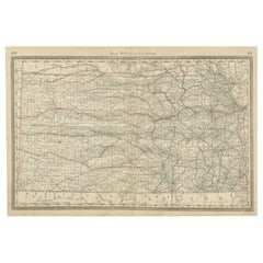
Large Original Antique Map of Arkansas by Rand McNally, circa 1900
By Rand McNally
Co.
Located in St Annes, Lancashire
Fabulous monochrome map with red outline color
Original color
By Rand, McNally & Co.
Published, circa 1900
Unframed
Minor edge tears.
Category
Antique Early 1900s American Edwardian Maps
Materials
Paper

$90
Free Shipping
H 20.5 in W 27.5 in D 0.07 in
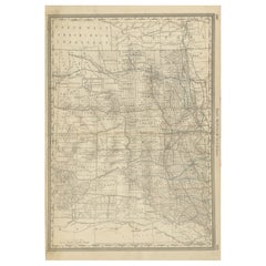
Original Antique Map of South Dakota by Rand McNally, circa 1900
By Rand McNally
Co.
Located in St Annes, Lancashire
Fabulous monochrome map with red outline color
Original color
By Rand, McNally & Co.
Published, circa 1900
Unframed
Minor edge tears.
Category
Antique Early 1900s American Edwardian Maps
Materials
Paper

$90
Free Shipping
H 14 in W 20.5 in D 0.07 in
World Antique Map c.1888 – Rand McNally, Continents
Territories
Located in Langweer, NL
Antique Map of Mexico – Rand McNally, circa 1888
This antique map titled “Rand, McNally & Co.’s Mexico” was published around 1888 and depicts Mexico in the late 19th century, a peri...
Category
Antique Late 19th Century American Maps
Materials
Paper
World Relief Map
Located in Antwerp, BE
Large world relief map.
Measures: Width 232 cm.
Height 158 cm.
Category
Mid-20th Century German Mid-Century Modern Maps
Materials
Acrylic

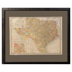
1912 "Texas" Map by Rand McNally
Co.
By Rand McNally
Co.
Located in Colorado Springs, CO
Presented is a very detailed map of Texas, from Rand McNally, printed in 1912. The map is very comprehensive, colored by counties, and outlined in black. The map shows the topography...
Category
Vintage 1910s American Maps
Materials
Paper
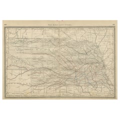
Nebraska Railroad Map 1888 – Rand McNally Antique Lithograph
Located in Langweer, NL
Nebraska Railroad Map 1888 – Rand McNally Antique Lithograph
This finely detailed map of Nebraska, published by Rand, McNally & Co. in 1888, provides an excellent overview of the st...
Category
Antique Late 19th Century American Maps
Materials
Paper
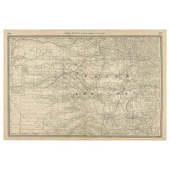
Indian Territory Map 1888 – Rand McNally Antique Lithograph
Located in Langweer, NL
Indian Territory Map 1888 – Rand McNally Antique Lithograph
This antique 1888 map of Indian Territory, published by Rand, McNally & Co., is a remarkable record of the region that wo...
Category
Antique Late 19th Century American Maps
Materials
Paper
Kansas Railroad Map 1888 – Rand McNally Antique Lithograph
Located in Langweer, NL
Kansas Railroad Map 1888 – Rand McNally Antique Lithograph
This antique 1888 map of Kansas by Rand, McNally & Co. offers a detailed view of the state during a period of rapid expans...
Category
Antique Late 19th Century American Maps
Materials
Paper
Dakota Territory Railroad Map 1888 – Rand McNally Antique Lithograph
Located in Langweer, NL
Antique Map of Dakota Territory – Rand McNally Railroad Map, 1888
This detailed 1888 map of Dakota by Rand, McNally & Co. captures the region in the final year before its division i...
Category
Antique Late 19th Century American Maps
Materials
Paper
$550
H 20.67 in W 14.18 in D 0.01 in
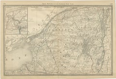
Antique Map of Northern New York – Rand McNally, circa 1888
Located in Langweer, NL
Antique Map of Northern New York – Rand McNally, circa 1888
This antique map of northern New York was published by Rand, McNally & Co. around 1888. Taken from one of their late 19th...
Category
Antique Late 19th Century American Maps
Materials
Paper
More From This Seller
View AllVincenzo Coronelli
s Colored Map of the New World Western Hemisphere Framed 47"
By Vincenzo Coronelli
Located in Dayton, OH
A Framed Reproduction of Coronelli's Map of the New World, Attributed to Trevor James Company. The map shows the Western Hemisphere including the discoveries made by Abel Tasman in A...
Category
20th Century Maps
Materials
Paper

$945 Sale Price
30% Off
20th Century Large Vintage Oval Wall Map of the World Globe Conference Table 13
Located in Dayton, OH
Monumental oval classroom map of the world / wall globe from the second half of the 20th century. A two piece sculpture design made with heavy wood and metal trim paneling. Can be ...
Category
20th Century Maps
Materials
Metal

$2,100 Sale Price
30% Off
Antique Chicago Illinois National Map Commercial Rollup Classroom Census Map 47"
Located in Dayton, OH
Antique early to mid 20th century double sided hanging map titled the New Commercial and Census Map of Illinois, Edition 1073. Verso shows the National Map of Chicago and Suburbs - O...
Category
Early 20th Century North American Maps
Materials
Paper

$822 Sale Price
30% Off
Antique Colored Belgium Map Flandria Gallica Flanders Henricus Hondius
Located in Dayton, OH
Antique hand colored map of Flanders, Belgium, engraved by Henricus Hondius.
Sans frame - 21.25” x 18”.
Category
Antique 19th Century Renaissance Maps
Materials
Paper

$245 Sale Price
30% Off
Vintage Oversized New York City Lower Manhattan 1840s Map Print
Located in Dayton, OH
Vintage late 20th century reproduction print of New York City featuring lower Manhattan in 1840.
Category
Late 20th Century Victorian Maps
Materials
Paper

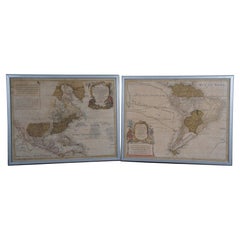
18th Century Antique Conrad Lotter Septentrionalis Meridionalis American Maps
Located in Dayton, OH
Pair of rare hand colored maps from the 1770's, depicting "America Septentrionalis" (North America), engraved by Georg Friedrich Lotter and America Meridionalis (South America), engr...
Category
Antique 18th Century Maps
Materials
Paper
$2,100 Sale Price
30% Off
Still Thinking About These?
All Recently ViewedMore Ways To Browse
Burlwood Frame
Framed World Map
Map New Holland
Mauritius Antique Map
Nantucket Poster
Nicolas Baier
Ruben Benjamin
Washington Dc Map
Wood Carved Golfer
1681 Moses Pitt
Antique Map Bermuda
Antique Map Of Brooklyn
Antique Map Of Republic Of Texas
Extra Large Map
George Weymouth
Georgetown Map
Hemisphere Antiques
J Matthews