Want more images or videos?
Request additional images or videos from the seller
1 of 21
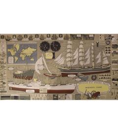
George Eldridge Chart "C" Vineyard Sound Lightship to Chatham
$3,495List Price
About the Item
- Dimensions:Height: 32 in (81.28 cm)Width: 52 in (132.08 cm)Depth: 2 in (5.08 cm)
- Materials and Techniques:
- Place of Origin:
- Period:1910-1919
- Date of Manufacture:1917
- Condition:
- Seller Location:Norwell, MA
- Reference Number:Seller: 81801stDibs: LU1741235627352
About the Seller
5.0
Vetted Professional Seller
Every seller passes strict standards for authenticity and reliability
Established in 1967
1stDibs seller since 2015
440 sales on 1stDibs
Typical response time: 1 hour
Authenticity Guarantee
In the unlikely event there’s an issue with an item’s authenticity, contact us within 1 year for a full refund. DetailsMoney-Back Guarantee
If your item is not as described, is damaged in transit, or does not arrive, contact us within 7 days for a full refund. Details24-Hour Cancellation
You have a 24-hour grace period in which to reconsider your purchase, with no questions asked.Vetted Professional Sellers
Our world-class sellers must adhere to strict standards for service and quality, maintaining the integrity of our listings.Price-Match Guarantee
If you find that a seller listed the same item for a lower price elsewhere, we’ll match it.Trusted Global Delivery
Our best-in-class carrier network provides specialized shipping options worldwide, including custom delivery.You May Also Like
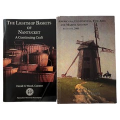
Nantucket Lightship Baskets
Auction Books
Located in Bradenton, FL
The Lightship Baskets of Nantucket, a continuing craft. Softcover book, stated first edition, published in 1994 by Nantucket Historical Association. Illustrated, 62 pages.
Americana...
Category
Late 20th Century Books
Materials
Paper
Rare North Atlantic and Caribbean Sea Chart: Newfoundland to Venezuela, 1745
Located in Langweer, NL
This impressive map titled "Terra Neuf, en de Custen van Nieu Vranckryck, Nieuw Engeland... Venezuela," published by Louis Renard in 1745, captures the North Atlantic coastline, enco...
Category
Antique 1740s Maps
Materials
Paper
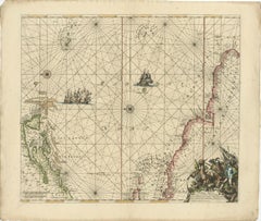
$2,278 Sale Price
20% Off
H 22.05 in W 25.99 in D 0.01 in
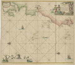
Hand-colored Nautical Chart: St. George
s Channel and the Irish Sea, 1744
Located in Langweer, NL
The map was engraved by Richard William Seale, a notable British engraver. This map is a fine example of 18th-century cartography, particularly focused on maritime navigation.
The m...
Category
Antique 1740s Maps
Materials
Paper
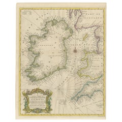
$626 Sale Price
20% Off
H 20.16 in W 15.56 in D 0 in
Mariner
s Chart Poster
Located in Hamilton, Ontario
Mariner's chart poster (nautical).
Category
20th Century Posters
Vineyards and vignerons Hardcover 1979
Located in Moreno Valley, CA
The Wines Vineyards and Vignerons of Australia by Andre SIMON.
First edition. Quarto, 194 pp.
Color and black & white illustrations.
Written by the prolific author, and founder of th...
Category
Mid-20th Century Australian Rustic Books
Materials
Paper

Original Antique Sea Chart of the Coastline from England to Gibraltar, ca.1700
Located in Langweer, NL
Antique map titled 'A Chart of the Sea-Coast from England to the Streights.'
Original antique map showing the European coastline from the South of England (and North of France) to ...
Category
Antique Early 1700s Maps
Materials
Paper
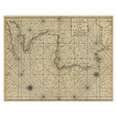
$1,127
H 18.47 in W 23.55 in D 0 in
1717 Johannes Van Keulen Sea Chart of the Eastern Atlantic - Amsterdam to Gambia
Located in Langweer, NL
1717 Johannes Van Keulen Sea Chart of the Eastern Atlantic - Amsterdam to Gambia
This 1717 sea chart by Johannes Van Keulen, titled "Nieuwe Paskaert vande ...
Category
Antique 1710s Dutch Maps
Materials
Paper
$2,002 Sale Price
25% Off
H 20.87 in W 23.82 in D 0.01 in
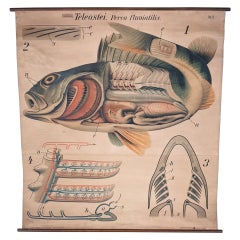
Antique Zoological Wall Chart
Located in Oakville, CT
Antique Pfurtscheller wall chart
Overall Dimensions: 53" x 56"
Chart Dimensions: 50 1/2" x 56
Materials: Paper & Linen.
Category
Antique Late 19th Century Austrian Posters
Materials
Linen, Paper
Made in Italy Sound Amplifier, Red Sound Amplifier, Customizable Speaker, 2022
By Mosche Bianche
Located in San Miniato PI, IT
Description
This is an amplifier compatible with all smartphones in which the speaker is positioned at the bottom, near the microphone. It will allow you to increase the volume of y...
Category
2010s Italian Modern Musical Instruments
Materials
Ceramic

$147 Sale Price / item
20% Off
H 4.73 in W 3.94 in D 7.88 in
Made in Italy Sound Amplifier, Green Sound Amplifier, Customizable Speaker, 2022
By Mosche Bianche
Located in San Miniato PI, IT
Description
This is an amplifier compatible with all smartphones in which the speaker is positioned at the bottom, near the microphone. It will allow you to increase the volume of y...
Category
2010s Italian Modern Musical Instruments
Materials
Ceramic
$147 Sale Price / item
20% Off
H 4.73 in W 3.94 in D 7.88 in
More From This Seller
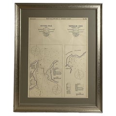
View AllMariners Chart of Quicks Hole and Tarpaulin Cove by George Eldridge 1901
Located in Norwell, MA
Nautical chart showing the harbor and local waters of Naushon Island Quick Holes. The chart display depths buoys, lightness, etc., The chart shows the cove in Naushon with ships stor...
Category
Antique Early 1900s North American Maps
Materials
Paper
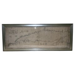
1905 Chart of Long Island Sound by Eldridge
Located in Norwell, MA
Original chart of Long Island Sound by George Eldridge, date-stamped 1905. Also includes the seller's name, Ships Chandler Charles C. Hutchinson, 152 State St., Boston, General Agent...
Category
Antique Early 1900s North American Prints
Materials
Paper
1873 Martha
s Vineyard and Nantucket Chart
Located in Norwell, MA
Original chart of Nantucket and Martha's Vineyard by George Eldridge, Cartographer, 125 State Street, Boston. Dated 1873. Mounted to canvas. Also showing the coast of Cape Cod includ...
Category
Antique 1870s North American Maps
Materials
Paper

Mariners Chart of Marion Massachussets by George Eldridge 1901
Located in Norwell, MA
Nautical chart showing the harbor and local waters of Marion Harbor., The chart displays depth, buoys, lighthouses, etc., Shown are Planting Island, Ram Island, Sippican Neck, Little...
Category
Antique Early 1900s North American Prints
Materials
Paper

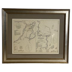
Mariners Chart of Gloucester and Rockport by George Eldridge 1910
Located in Norwell, MA
Nautical chart showing the harbor and local water. The chart display depths buoys, lighthouses, etc., This chart shows Eastern Point, Rocky Neck, Stage head, Thatcher Island, Sandy B...
Category
Vintage 1910s North American Prints
Materials
Paper
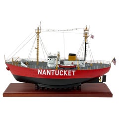
Nantucket Lightship 612 Scale Model
Located in Norwell, MA
Scale model of the Nantucket lightship. This is the Lightship 612 that is now owned by Bill Golden. The model was professionally built for the pers...
Category
Early 2000s North American Models and Miniatures
Materials
Wood