Items Similar to Germany
Central Europe – Antique 1865 Map by Andriveau-Goujon, Paris

Want more images or videos?
Request additional images or videos from the seller
1 of 10
Germany
Central Europe – Antique 1865 Map by Andriveau-Goujon, Paris
$468.39
£346.96
€390
CA$640.87
A$697.32
CHF 369.22
MX$8,389.23
NOK 4,688.30
SEK 4,289.47
DKK 2,972.12
About the Item
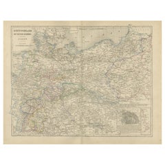
Antique Map of Germany and Central Europe – “Allemagne et Europe Centrale” by Andriveau-Goujon, 1865
This large, finely engraved map titled “Allemagne et Europe Centrale” was published in Paris in 1865 by E. Andriveau-Goujon, one of the most prominent 19th-century French map publishers. Issued as plate number 28 in the Atlas Universel, the map provides a highly detailed depiction of Central Europe on the eve of German unification, encompassing the German Confederation, the Austrian Empire, and neighboring states in their mid-19th-century political configuration.
The map covers a vast area from the Netherlands and eastern France in the west to Poland and western Russia in the east, and from the North Sea and Baltic Sea down to northern Italy, Hungary, and the Balkans. It captures the fragmented nature of the German states at the time, with Prussia, Bavaria, Saxony, Württemberg, Hanover, and numerous smaller duchies, bishoprics, and free cities all rendered in distinct pastel colors.
To the southeast, the map illustrates the full extent of the Austrian Empire in yellow, including modern-day Austria, Hungary, the Czech Republic, Slovakia, and parts of the Balkans. Important cities such as Berlin, Vienna, Munich, Frankfurt, Prague, Dresden, and Budapest are all clearly marked, along with roads, rivers, and administrative boundaries.
In the upper right corner, a legend titled “Abbreviations” lists the German Confederation’s member states and principal regions, such as the Kingdom of Prussia, Grand Duchy of Baden, and Duchy of Brunswick. At the bottom right, a key to symbols defines capital cities, fortified towns, and religious centers.
This map is a valuable historical record of Central Europe before the political reconfigurations brought about by the Austro-Prussian War of 1866 and the creation of the German Empire in 1871. It appeals to collectors interested in European history, German unification, and 19th-century political geography.
Condition: Very good. Light toning and minor foxing in the margins, original centerfold as issued. Clean engraving with delicate original hand coloring. Plate number 28 in upper right.
Framing tips: A dark wood or antique gold frame with a cream mat will highlight the detailed engraving and period colors. A muted green or burgundy inner mat could enhance the central European palette.
Technique: Engraving with original hand coloring
Maker: E. Andriveau-Goujon, Paris, 1865
- Dimensions:Height: 20.91 in (53.1 cm)Width: 27.64 in (70.2 cm)Depth: 0.01 in (0.2 mm)
- Materials and Techniques:Paper,Engraved
- Place of Origin:
- Period:
- Date of Manufacture:1865
- Condition:Condition: Very good. Light toning and minor foxing in the margins, original centerfold as issued. Clean engraving with delicate original hand coloring. Plate number 28 in upper right.
- Seller Location:Langweer, NL
- Reference Number:Seller: BG-14099-81stDibs: LU3054346185422
About the Seller
5.0
Recognized Seller
These prestigious sellers are industry leaders and represent the highest echelon for item quality and design.
Platinum Seller
Premium sellers with a 4.7+ rating and 24-hour response times
Established in 2009
1stDibs seller since 2017
2,816 sales on 1stDibs
Typical response time: 1 hour
- ShippingRetrieving quote...Shipping from: Langweer, Netherlands
- Return Policy
More From This Seller
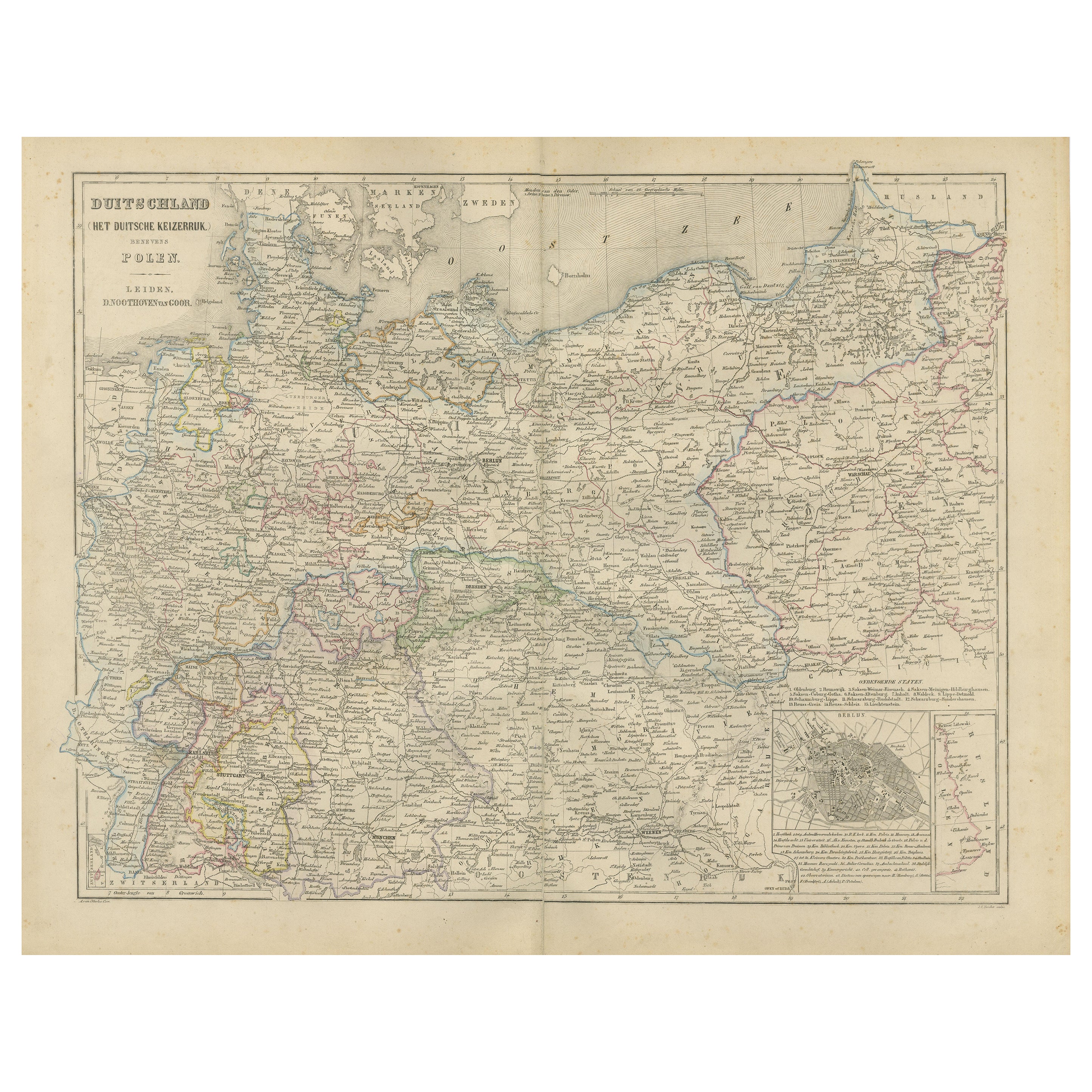
View AllGermany Map with Berlin Inset – Het Duitsche Keizerrijk, Nieuwe Hand-Atlas 1876
Located in Langweer, NL
Germany Map with Berlin Inset – Het Duitsche Keizerrijk, Nieuwe Hand-Atlas 1876
This detailed 19th-century map of Germany, titled “Deutschland (Het Duitsche Keizerrijk),” was publis...
Category
Antique 1870s Dutch Maps
Materials
Paper
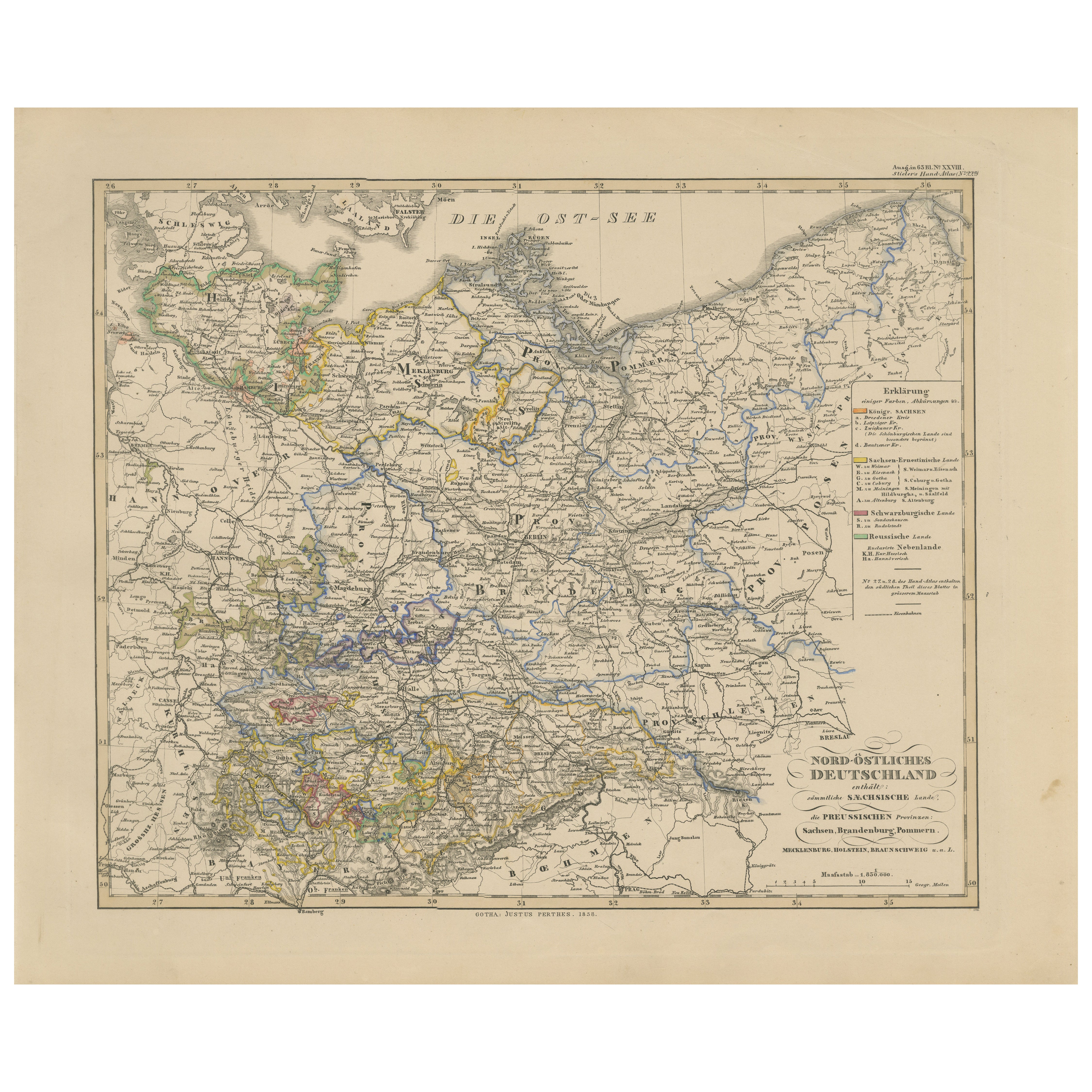
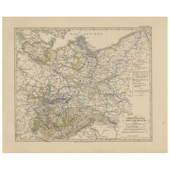
Antique Map of Northeastern Germany – Saxon
Prussian States, 1858
Located in Langweer, NL
Antique Map of Northeastern Germany – Saxon & Prussian States, 1858
Detailed and finely engraved map titled "Nord-Östliches Deutschland enthaltend die Sächsischen Länder und die Pre...
Category
Antique Mid-19th Century German Maps
Materials
Paper
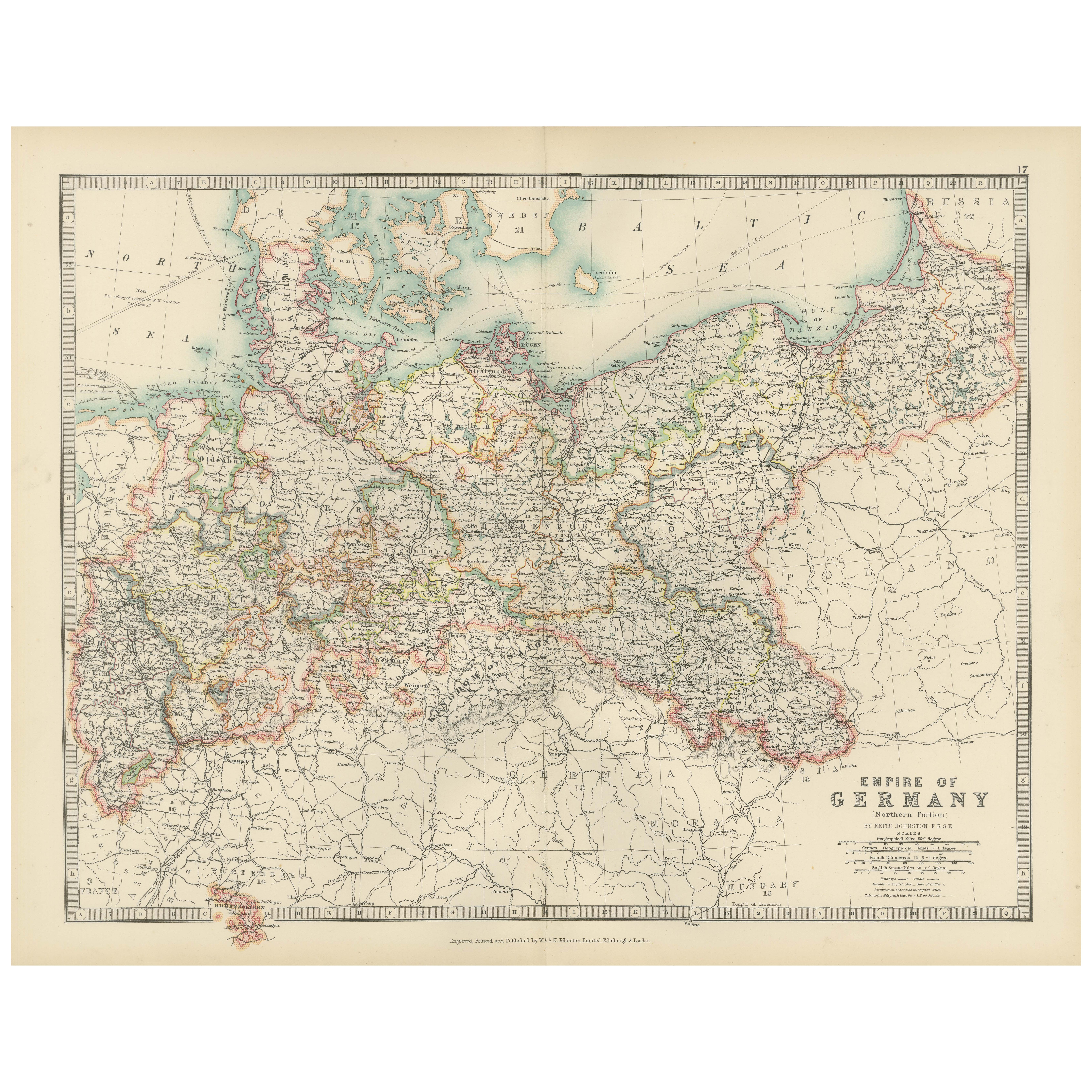
Antique Map of the German Empire, 1903, Northern Portion with Coastal and Inland
Located in Langweer, NL
Title: Antique Map of the German Empire, 1903, Northern Portion with Coastal and Inland Detail
Description:
This antique map, titled "Empire of Germany (Northern Portion)," was engr...
Category
Early 20th Century Maps
Materials
Paper

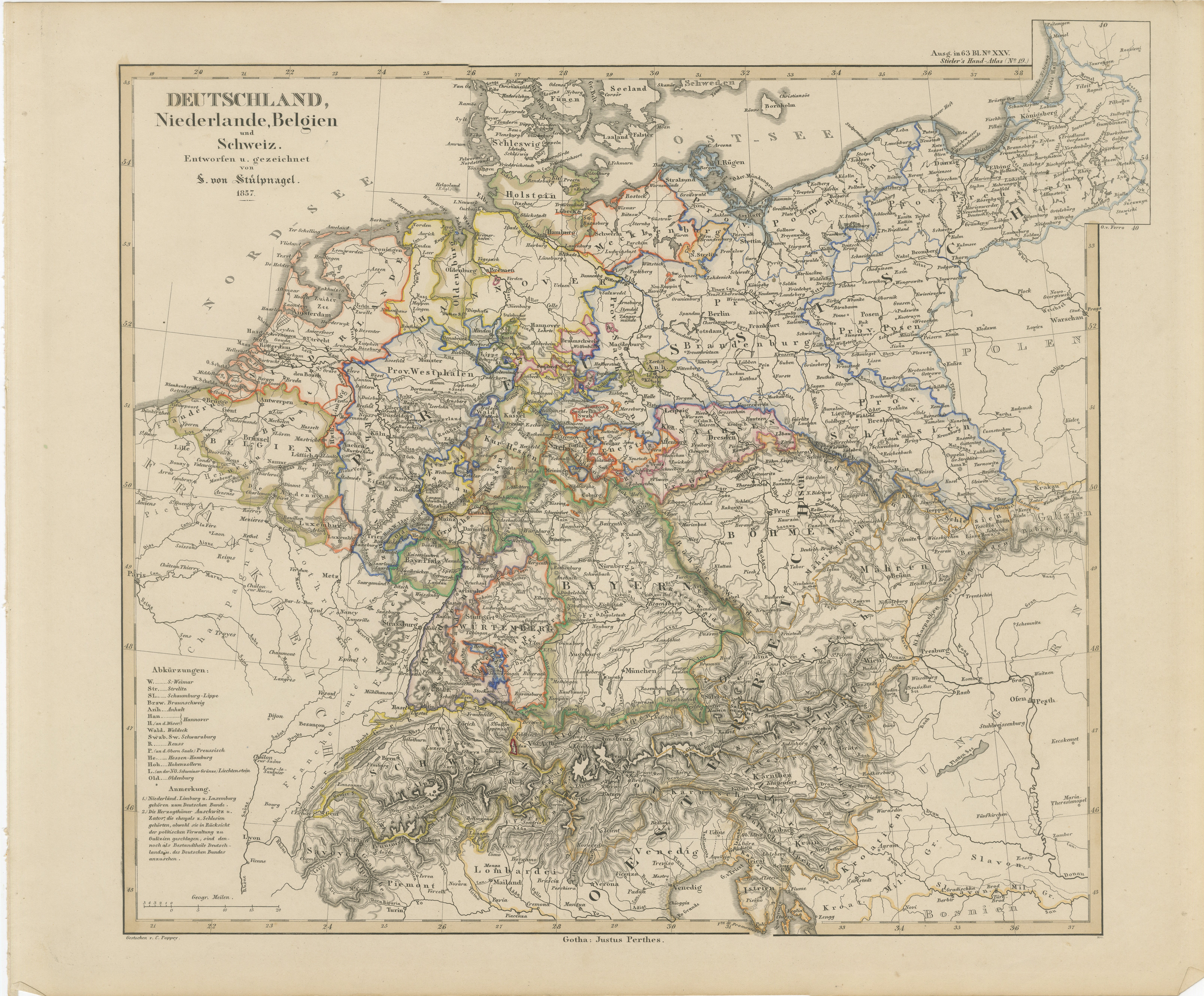
Antique Map of Germany, Netherlands, Belgium
Switzerland – Stülpnagel, 1857
Located in Langweer, NL
Antique Map of Germany, Netherlands, Belgium & Switzerland – Stülpnagel, 1857
Fine mid-19th century map of Central Europe titled "Deutschland, Niederlande, Belgien, Schweiz", drawn ...
Category
Antique Mid-19th Century German Maps
Materials
Paper

Antique 1842 Map of Germany by Pierre M. Lapie, Mid-19th Century
Located in Langweer, NL
Antique map titled 'Carte de la Germanie Ancienne'. Map of Germany. This map originates from 'Atlas universel de géographie ancienne et moderne (..)' by...
Category
Antique Mid-19th Century French Maps
Materials
Paper

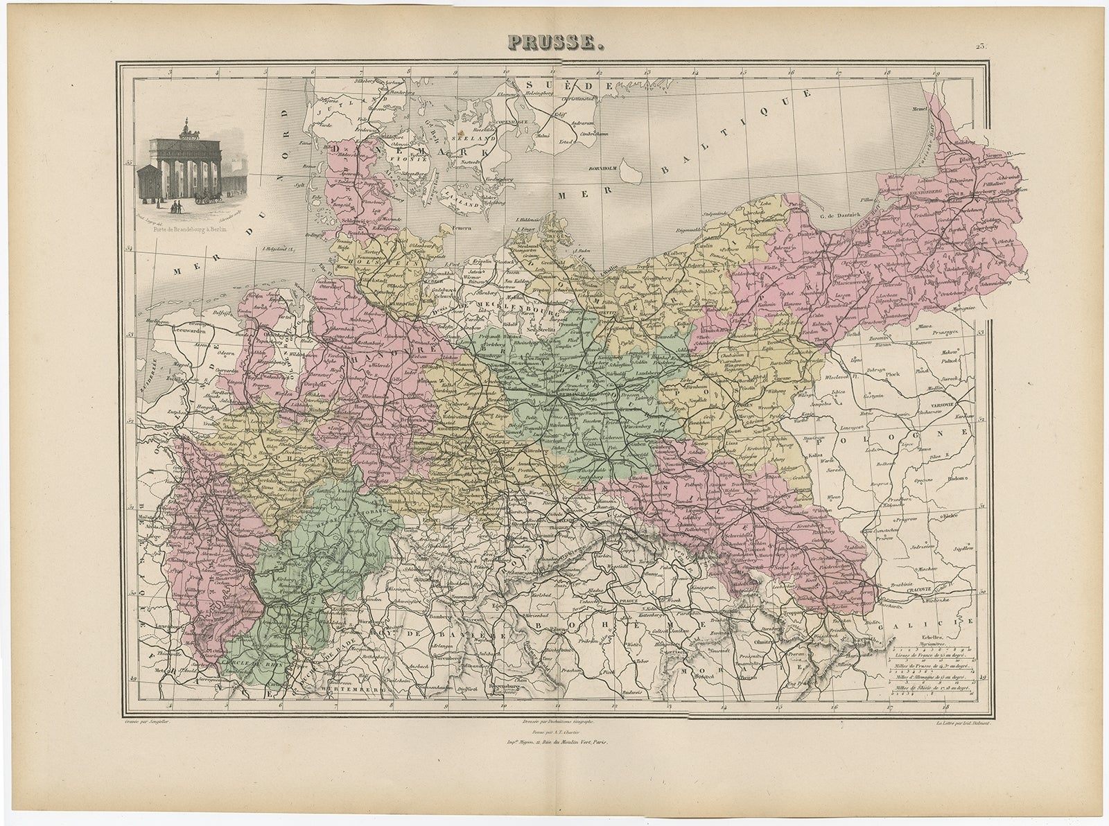
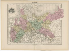
Antique Map of the Kingdom of Prussia, 1880
Located in Langweer, NL
Antique map titled 'Prusse'. Old map of the Kingdom of Prussia, with a decorative vignette of the gate of Brandenburg, Berlin. This map originates from 'Géographie Universelle Atlas-...
Category
Antique 19th Century Maps
Materials
Paper
You May Also Like
German Empire, Northern Part. Century Atlas antique vintage map
Located in Melbourne, Victoria
'The Century Atlas. German Empire, Northern Part.'
Original antique map, 1903.
Central fold as issued. Map name and number printed on the reverse corne...
Category
Early 20th Century Victorian More Prints
Materials
Lithograph

German Empire, Southwestern Part. Century Atlas antique vintage map
Located in Melbourne, Victoria
'The Century Atlas. German Empire, Southwestern Part'
Original antique map, 1903.
Central fold as issued. Map name and number printed on the reverse co...
Category
Early 20th Century Victorian More Prints
Materials
Lithograph

1853 Map of "Russia in Europe Including Poland" Ric.r016
Located in Norton, MA
Description
Russia in Europe incl. Poland by J Wyld c.1853
Hand coloured steel engraving
Dimension: Paper: 25 cm W x 33 cm H ; Sight: 22 cm W x 28 cm H
Condition: Good ...
Category
Antique 19th Century Unknown Maps
Materials
Paper

Austria-Hungary, Western Part. Century Atlas antique vintage map
Located in Melbourne, Victoria
'The Century Atlas. Austria-Hungary, Western Part'
Original antique map, 1903.
Central fold as issued. Map name and number printed on the reverse corners.
Sheet 40cm by 29.5cm.
Category
Early 20th Century Victorian More Prints
Materials
Lithograph

Russia, Western and Southern Part. Century Atlas antique vintage map
Located in Melbourne, Victoria
'The Century Atlas. Russia, Western and Southern Part'
Original antique map, 1903.
Inset map tilted 'St Petersburg and Environs'.
Central fold as issued. Map name and number printe...
Category
Early 20th Century Victorian More Prints
Materials
Lithograph

Russia in Europe with Poland and Finland. Century Atlas antique vintage map
Located in Melbourne, Victoria
'The Century Atlas. Russia in Europe with Poland and Finland'
Original antique map, 1903.
Central fold as issued. Map name and number printed on the reverse corners.
Sheet 40cm by ...
Category
Early 20th Century Victorian More Prints
Materials
Lithograph

More Ways To Browse
Bavaria Antique
German Empire
Austrian Empire
City Antique Vienna
Pair Of Danish Chairs
Veneer Dining Tables
1970 Italian Armchair
Furniture Uk
House Of Denmark Table And Chairs
Louis Marble Top Side Table
Antique Russian Rugs
Baker Furniture By
For Kids
Sterling Silver Flatware Set Service For 12
Tufted Bar
Pair Of French Antique Armchairs
1970s Brass Glass Coffee Table
Antique Column Base