Items Similar to Girona 1902: Geographic and Infrastructural Map of Catalonia’s Northern Province


Want more images or videos?
Request additional images or videos from the seller
1 of 6
Girona 1902: Geographic and Infrastructural Map of Catalonia’s Northern Province
$373.38
$466.7320% Off
£279.52
£349.4020% Off
€312
€39020% Off
CA$514.01
CA$642.5120% Off
A$561.91
A$702.3920% Off
CHF 297.28
CHF 371.5920% Off
MX$6,724.16
MX$8,405.2020% Off
NOK 3,782.41
NOK 4,728.0120% Off
SEK 3,462.41
SEK 4,328.0120% Off
DKK 2,377.06
DKK 2,971.3220% Off
About the Item
The map provided is of the province of Girona (in Catalan, Girona), located in the northeast of Spain, within the autonomous community of Catalonia, as of the year 1902. Here are the key features:
The map details the mountainous landscape of the Pyrenees along the northern border and the more gentle relief towards the Mediterranean coast. It shows Girona's extensive coastline, including the Costa Brava, known for its rugged beauty and beaches.
Blue lines indicate rivers, likely including the Onyar, Ter, and Fluvia, which flow through the province. Red lines represent the transportation network of roads and railways, demonstrating the infrastructure connecting Girona's towns and cities. Symbols mark the locations of cities, towns, and villages, with the capital city, also named Girona, emphasized. Dotted lines may represent the administrative boundaries within Catalonia.
The coat of arms of Girona is prominently displayed, featuring elements that symbolize the province's heritage.
About the province of Girona:
Girona is known for its rich history, which includes Iberian, Greek, Roman, and Arab influences, as evidenced by the diverse architectural heritage found throughout the province. The capital city, Girona, has a well-preserved medieval quarter with historic baths and the Girona Cathedral. The province's landscape ranges from the Pyrenees mountains to the scenic Costa Brava. Girona is also known for its natural parks, such as the Cap de Creus, the Aiguamolls de l'Empordà, and part of the Garrotxa Volcanic Zone Natural Park. The region has a strong culinary reputation, with several renowned restaurants and a tradition of producing high-quality products like wine, olive oil, and seafood. The province's economy is diversified, including tourism, agriculture, and services.
- Dimensions:Height: 14.77 in (37.5 cm)Width: 20.08 in (51 cm)Depth: 0 in (0.02 mm)
- Materials and Techniques:
- Period:1900-1909
- Date of Manufacture:1901
- Condition:Good condition. Central vertical folding lines as issued. Aged paper with typically warm, yellowish-brown hue, especially around the edges. Check the images carefully.
- Seller Location:Langweer, NL
- Reference Number:Seller: BG-13642-161stDibs: LU3054338031792
About the Seller
5.0
Recognized Seller
These prestigious sellers are industry leaders and represent the highest echelon for item quality and design.
Platinum Seller
Premium sellers with a 4.7+ rating and 24-hour response times
Established in 2009
1stDibs seller since 2017
2,792 sales on 1stDibs
Typical response time: <1 hour
- ShippingRetrieving quote...Shipping from: Langweer, Netherlands
- Return Policy
More From This Seller
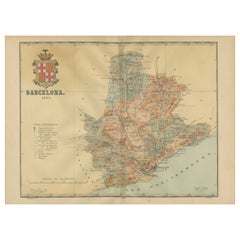
View AllBarcelona 1901: A Cartographic Portrait of Catalonia
s Capital Province
Located in Langweer, NL
This orignal antique map is a historical depiction of the province of Barcelona from 1901.
It showcases the varied terrain of the province, with the Serra de Collserola ridge near the city of Barcelona and the Pyrenees to the north. The map includes the coastline along the Mediterranean Sea, indicating Barcelona's position as a coastal province. Blue lines indicate rivers, such as the Llobregat and Besòs, which are significant features in the province's geography. Dotted lines may signify the borders of the province within Catalonia.
The coat of arms of Barcelona, highlighted with gold, is prominently displayed, featuring the Cross of Saint George (Cruz de Sant Jordi), the patron saint of Catalonia, and the red and yellow bars which are a symbol of the Aragonese and Catalan heritage.
About the province of Barcelona:
The province of Barcelona is part of the autonomous community of Catalonia in northeastern Spain. It is the most economically significant region of Catalonia, playing a crucial role in the country's economy due to its port, manufacturing, and service industries. The city of Barcelona is the capital and the second most populous city in Spain, known for its rich cultural heritage, architecture by Antoni Gaudí, such as the Sagrada Família, and its influential art scene. The province enjoys a Mediterranean climate and features diverse landscapes from the beaches along the coast to the mountains in the interior. Barcelona is also known for its vibrant festivals, cuisine, fashion, and sports, particularly football, being home to FC Barcelona...
Category
Antique Early 1900s Maps
Materials
Paper
$631 Sale Price
20% Off
Free Shipping
Navarra in Cartographic Detail: A 1902 Map of the Crossroads of Northern Spain
Located in Langweer, NL
The original antique map for sale shows the Spanish province of Navarra as it was in 1902. Here's a brief description and a potential title for the map:
Description:
- The map detai...
Category
Antique Early 1900s Maps
Materials
Paper

$325 Sale Price
20% Off
Free Shipping
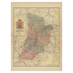
Lleida 1902: A Cartographic Perspective of Catalonia
s Gateway to the Pyrenees
Located in Langweer, NL
The map for sale shows the province of Lleida, located in the western part of Catalonia, Spain, as of 1902. Here are the key features depicted on the map:
- **Topography**: The map ...
Category
Antique Early 1900s Maps
Materials
Paper
$287 Sale Price
20% Off
Free Shipping
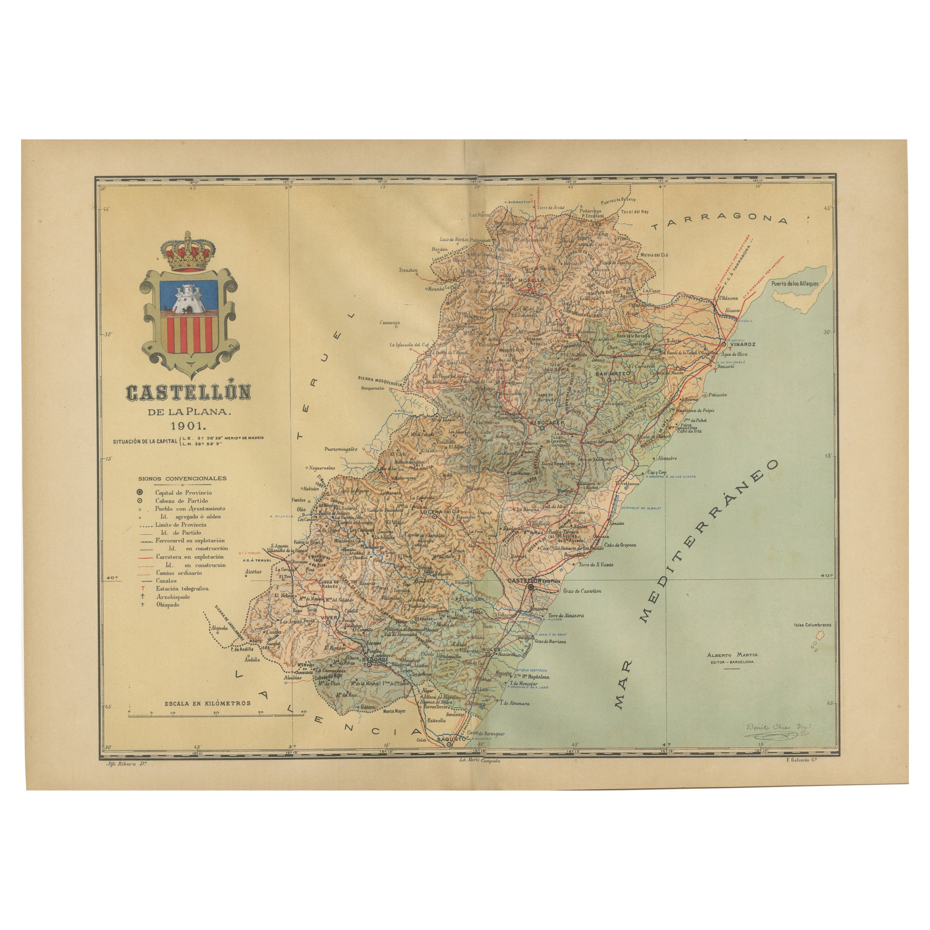
Castellón de la Plana 1901: A Cartographic Perspective of the Valencian Coast
Located in Langweer, NL
The authentic map depicts the province of Castellón de la Plana, often referred to simply as Castellón, situated in the eastern part of Spain in the Valencian Community, and the map ...
Category
Antique Early 1900s Maps
Materials
Paper

$402 Sale Price
20% Off
Free Shipping
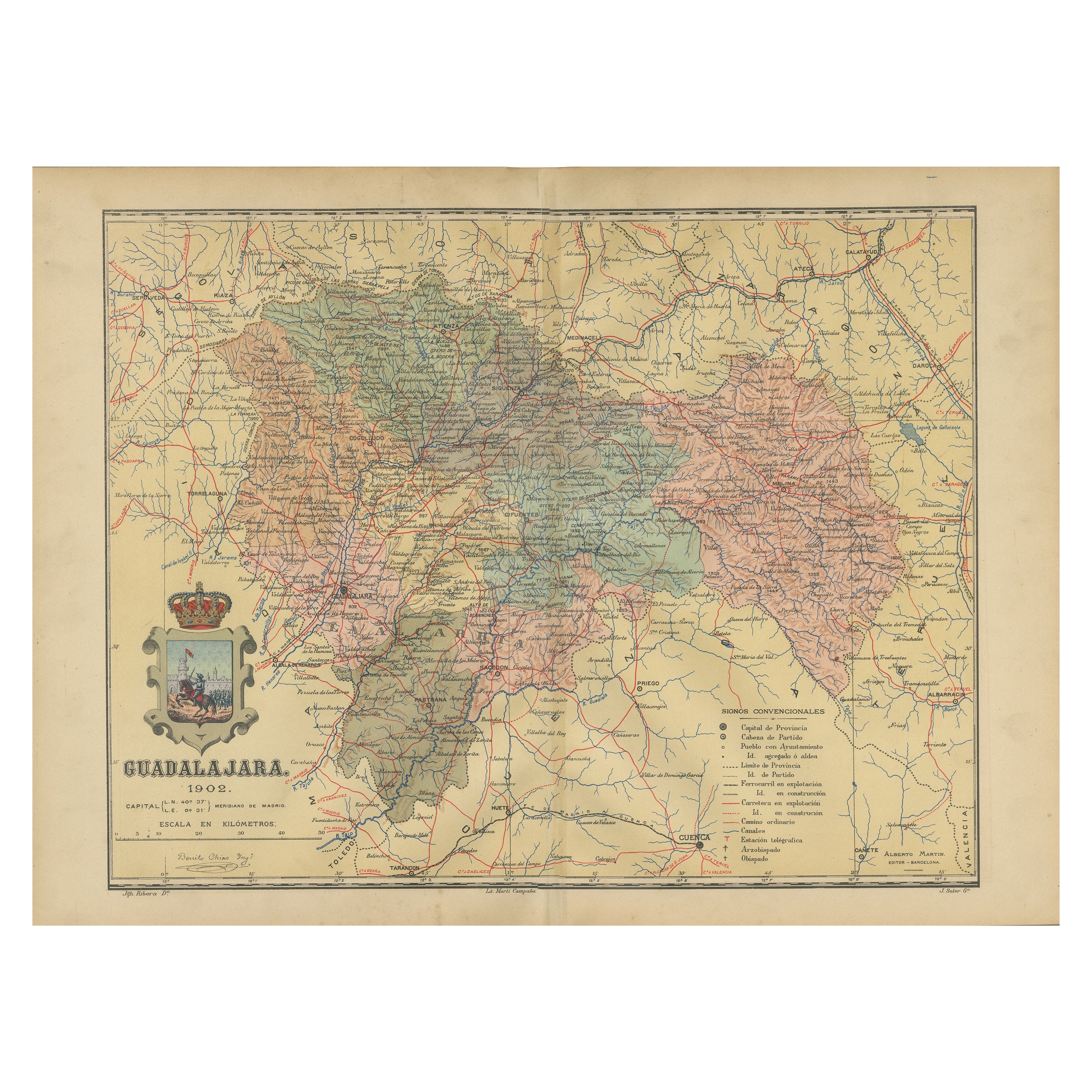
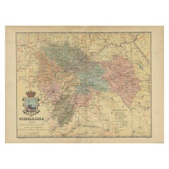
Guadalajara 1902: A Cartographic Image of Castilla-La Mancha
s Northern Province
Located in Langweer, NL
The map illustrates the province of Guadalajara, part of the autonomous community of Castilla-La Mancha in Spain, as of 1902. The map includes various geographic and infrastructural ...
Category
Antique Early 1900s Maps
Materials
Paper
$277 Sale Price
20% Off
Free Shipping
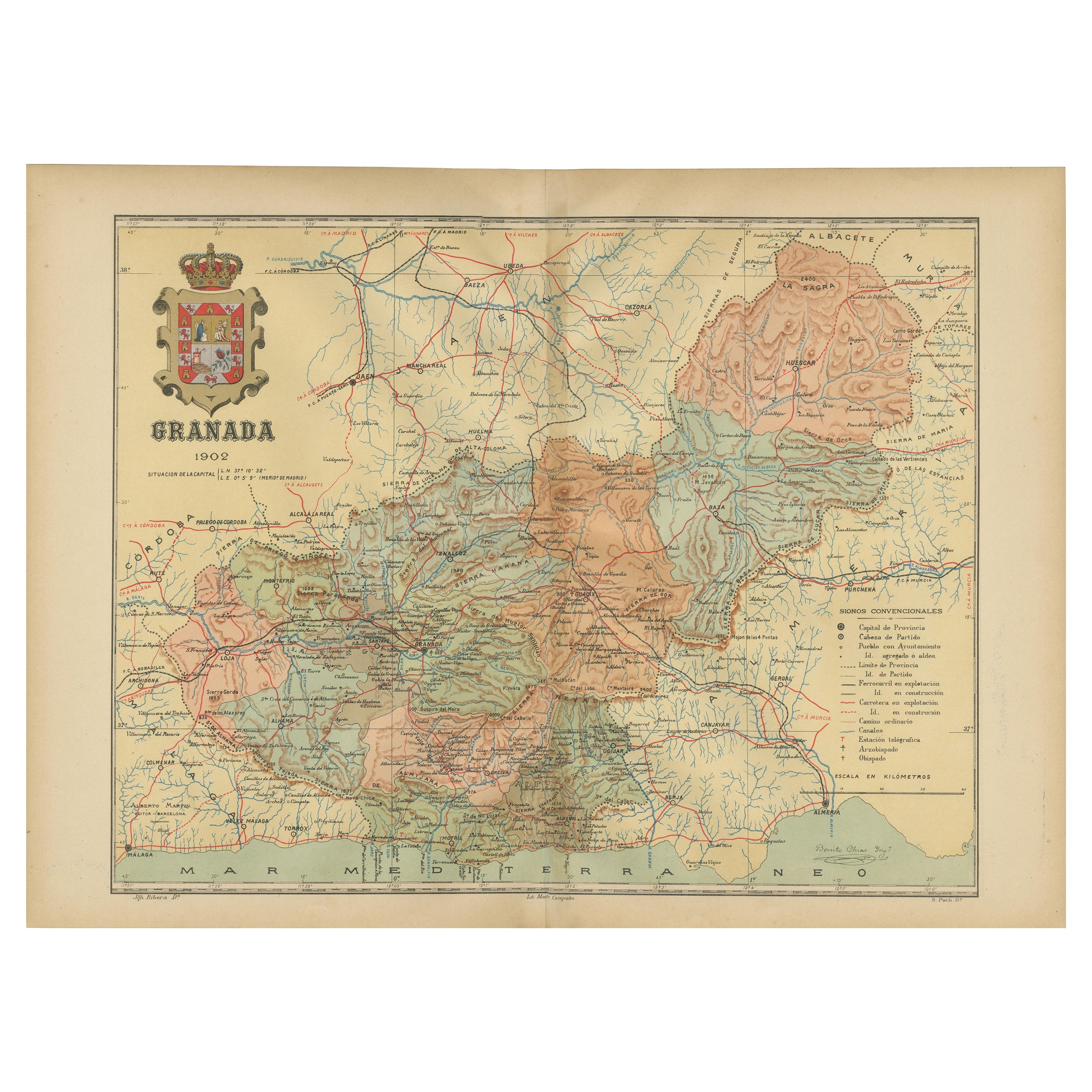
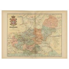
Granada 1902: A Cartographic Exploration of Andalusia
s Mountainous Province
Located in Langweer, NL
This original antique map depicts the province of Granada, part of the autonomous community of Andalusia in southern Spain, as of 1902. The map features several important details:
I...
Category
Antique Early 1900s Maps
Materials
Paper
$373 Sale Price
20% Off
Free Shipping
You May Also Like
Large Original Vintage Map of Spain, circa 1920
Located in St Annes, Lancashire
Great map of Spain
Original color.
Good condition
Published by Alexander Gross
Unframed.
Category
Vintage 1920s English Maps
Materials
Paper

Map of the Republic of Genoa
Located in New York, NY
Framed antique hand-coloured map of the Republic of Genoa including the duchies of Mantua, Modena, and Parma.
Europe, late 18th century.
Dimension: 25...
Category
Antique Late 18th Century European Maps

Italy, Northern Part. Century Atlas antique vintage map
Located in Melbourne, Victoria
'The Century Atlas. Italy, Northern Part.'
Original antique map, 1903.
Central fold as issued. Map name and number printed on the reverse corners.
Sheet 29.5cm by 40cm.
Category
Early 20th Century Victorian More Prints
Materials
Lithograph

Italy, Central and Southern Part. Century Atlas antique map
Located in Melbourne, Victoria
'The Century Atlas. Italy, Central and Southern Part.'
Original antique map, 1903.
Inset maps of Sicily and Naples.
Central fold as issued. Map name an...
Category
Early 20th Century Victorian More Prints
Materials
Lithograph

Geographical Antique Map of Principality of Monaco
By Bruno Santini
Located in Alessandria, Piemonte
ST/609 - Interesting antique color map of Monaco Principality in French language : "Carte qui contient le Principauté de Piémont, le Monferrat et la comté de...
Category
Antique Late 18th Century Italian Other Maps
Materials
Paper

Geographical Map of Italy
Located in Alessandria, Piemonte
BOLIS Publishing House - Bergamo.
A beautiful large map of Italy, on paper but suitably reinforced to preserve it correctly. The maps were usually p...
Category
Mid-20th Century Italian Other Prints
Materials
Paper

More Ways To Browse
Antique Sultanabad Carpets
Used Beige Sofa
Antique Plate Germany
Hand Tufted Rugs
Rare China
Side Table Made In Denmark
Thonet Antique
Victorian Hall Tables
Vintage Computer
England Antique Plates
19th Century Round Dining Table
Antique Counters
Antique Thrones
Carved Chinese Tables
Italian Ceramic 1960s
Mid Century Modern Danish Teak Dining Tables
Rosenthal Century
Long Rug Runners