1 of 12
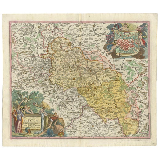
Hand-Colored 18th Century Homann Map of the Danube, Italy, Greece, Croatia
$875List Price
About the Item
- Creator:Johann Baptist Homann (Artist)
- Dimensions:Height: 20 in (50.8 cm)Width: 23.88 in (60.66 cm)Depth: 0.07 in (1.78 mm)
- Materials and Techniques:Paper,Engraved
- Place of Origin:
- Period:
- Date of Manufacture:1728
- Condition:Wear consistent with age and use.
- Seller Location:Alamo, CA
- Reference Number:Seller: # 1283 1stDibs: LU5206221023452
Johann Baptist Homann
Johann Baptist Homann (1663-1724) was a mapmaker who founded a respected and prolific publishing company, which continued long after his death as Homann Heirs. Homann lived his entire life in Bavaria, particularly in Nuremberg. Initially, Johann trained to become a priest before converting to Protestantism and working as a notary. In 1702, Johann founded a publishing house that specialized in engravings. The firm flourished, becoming the leading map publisher in Germany and an important entity in the European map market. In 1715, Johann was named Imperial Geographer to the Holy Roman Empire by Charles VI and made a member of the Prussian Academy of Sciences. Most importantly for his business, his reputation and contacts gained him imperial printing privileges which protected his publications and recommended him to customers.
Authenticity Guarantee
In the unlikely event there’s an issue with an item’s authenticity, contact us within 1 year for a full refund. DetailsMoney-Back Guarantee
If your item is not as described, is damaged in transit, or does not arrive, contact us within 7 days for a full refund. Details24-Hour Cancellation
You have a 24-hour grace period in which to reconsider your purchase, with no questions asked.Vetted Professional Sellers
Our world-class sellers must adhere to strict standards for service and quality, maintaining the integrity of our listings.Price-Match Guarantee
If you find that a seller listed the same item for a lower price elsewhere, we’ll match it.Trusted Global Delivery
Our best-in-class carrier network provides specialized shipping options worldwide, including custom delivery.You May Also Like
Stunning Antique Map of Northern Italy by J.B. Homann, circa 1745
By Johann Baptist Homann
Located in Langweer, NL
This beautiful hand-colored map covers from Bergamo east as far as Albona (Labin) and from Vipiteno Sterzing south as far as Florence.
The map is exceptionally detailed, noting towns, rivers, lakes, cities and a host of additional topographical features. Includes neighboring Parma, Modena, Mantua and Mirandol. The map depicts the Veneto region and its vicinity during the decline of the Republic of Venice. A key in included in the top left quadrant of the map, while a beautifully engraved title cartouche adorns the lower right quadrant. This map was issued in Homann Heirs circa 1745 edition of Atlas Novus Terrarum Orbis.
Category
Antique Mid-18th Century Maps
Materials
Paper

$624 Sale Price
25% Off
H 20.08 in W 23.82 in D 0.02 in
Antique Map of the Netherlands and Belgium by Homann, circa 1710
By Johann Baptist Homann
Located in Langweer, NL
Antique map titled 'Tabula Generalis Totius Belgii Provinciae XVII. Infer. Germaniae (..)'. Map of the Benelux countries by Johann Baptist Homann. Shows the area between the Seine es...
Category
Antique Early 18th Century German Maps
Materials
Paper

$946
Free Shipping
H 20.87 in W 24.02 in D 0.02 in
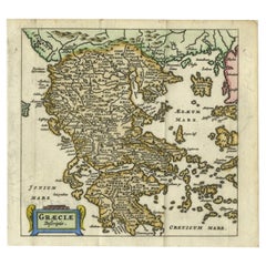
Charming 18th Century Miniature Map of Greece, 1685
Located in Langweer, NL
Antique map titled 'Graeciae Descriptio.' Charming miniature map of Greece from the pocket atlas 'Introductionis in Universam Geographiam tam Veterem qu...
Category
Antique 17th Century Maps
Materials
Paper
Greece and Ottoman Balkans Map – Homann Engraving ca. 1720
Located in Langweer, NL
Greece and the Danube Basin Map c.1720 – Antique Engraving of the Balkans
This remarkable early 18th-century map presents a sweeping view of southeastern Europe, centering on the co...
Category
Antique 18th Century German Maps
Materials
Paper

Antique 18th Century Map of the Province of Pensilvania
Pennsylvania State
Located in Philadelphia, PA
A fine antique of the colony of Pennsylvania.
Noted at the top of the sheet as a 'Map of the province of Pensilvania'.
This undated and anonymous map is thought to be from the Gentleman's Magazine, London, circa 1775, although the general appearance could date it to the 1760's.
The southern boundary reflects the Mason-Dixon survey (1768), the western boundary is placed just west of Pittsburgh, and the northern boundary is not marked.
The map has a number of reference points that likely refer to companion text and appear to be connected to boundaries. The western and southern boundaries are marked Q, R, S, for example. A diagonal line runs from the Susquehanna R to the Lake Erie P. A broken line marked by many letters A, B, N, O, etc., appears in the east.
There are no latitude or longitude markings, blank verso.
Framed in a shaped contemporary gilt wooden frame and matted under a cream colored matte.
Bearing an old Graham Arader Gallery...
Category
Antique 18th Century British American Colonial Maps
Materials
Paper

$1,250
H 10.25 in W 13.25 in D 0.5 in
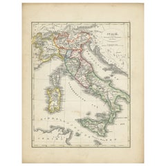
Antique Map of Italy with Hand-Colored Borders, 1852
Located in Langweer, NL
Antique map titled 'Italië'. Map of Italy. This map originates from 'School-Atlas van alle deelen der Aarde' by Otto Petri. Artists and Engravers: Published by A. Baedeker (Otto Petr...
Category
Antique 19th Century Maps
Materials
Paper
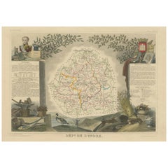
Hand Colored Antique Map of the department of Cantal, France
By Victor Levasseur
Located in Langweer, NL
Antique map titled 'Dépt. du Cantal'. Map of the French department of Cantal, France. This area of France is known for its production of Cantal, a firm cheese, named after the region...
Category
Antique Mid-19th Century Maps
Materials
Paper
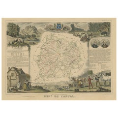
$325 Sale Price
20% Off
H 14.3 in W 21.58 in D 0.02 in
Hand Colored Antique Map of the Department of Indre, France
By Victor Levasseur
Located in Langweer, NL
Antique map titled 'Dept. de l'Indre'. Map of the French department of Indre, France. Part of the Loire Valley wine region, this area is known for its production of Chinon wines, typically red, and production of Pouligny-Saint-Pierre, goats'-milk cheese. It is also the birthplace of the great philosopher Rene Descartes...
Category
Antique Mid-19th Century Maps
Materials
Paper
$325 Sale Price
20% Off
H 14.49 in W 21.66 in D 0.02 in
Hand Colored Antique Map of the department of Lozere, France
By Victor Levasseur
Located in Langweer, NL
Antique map titled 'Dept. de la Lozère'. Map of the French department of Lozere, France. This remote mountainous part of Languedoc is rural, sparcely populated, and extremely beautif...
Category
Antique Mid-19th Century Maps
Materials
Paper
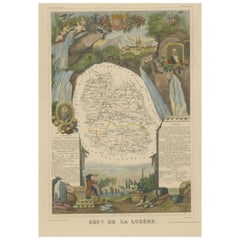
$325 Sale Price
20% Off
H 20.24 in W 14.3 in D 0.02 in
Hand Colored Antique Map of the Department of Nièvre, France
By Victor Levasseur
Located in Langweer, NL
Antique map titled 'Dept. de la Nièvre'. Map of the French department of Nievre, France. Part of the prestiegous Burgundy or Bourgogne wine region this area is known for its producti...
Category
Antique Mid-19th Century Maps
Materials
Paper
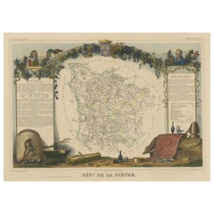
$325 Sale Price
20% Off
H 14.38 in W 20.36 in D 0.02 in