Items Similar to Hand-Colored Dutch Map of Ancient Israel Divided by the Twelve Tribes – c.1730


Want more images or videos?
Request additional images or videos from the seller
1 of 10
Hand-Colored Dutch Map of Ancient Israel Divided by the Twelve Tribes – c.1730
$444.70
£329.41
€370
CA$608.34
A$663.06
CHF 350.55
MX$7,981.96
NOK 4,449.39
SEK 4,079.18
DKK 2,819.20
About the Item
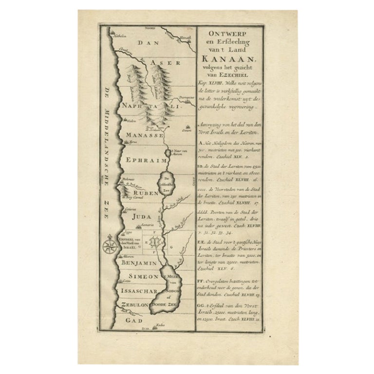
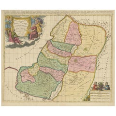
Hand-Colored Dutch Map of Ancient Israel Divided by the Twelve Tribes – After Ezekiel, c.1730
This beautifully hand-colored antique map is titled "Ontwerp en Erfdeeling van’t Land Kanaan, volgens het gezicht van Ezechiel," which translates to "Design and Division of the Land of Canaan, according to the vision of Ezekiel." Published around 1730, the map presents a theological reconstruction of the Holy Land based on the prophetic descriptions found in the Book of Ezekiel, particularly chapters 45 through 48.
The map depicts ancient Israel from Hethelon in the north to Kades in the south, laid out in horizontal bands representing the territories of the Twelve Tribes of Israel. These include Dan, Aser, Naphtali, Manasse, Ephraim, Ruben, Juda, Benjamin, Simeon, Issachar, Zebulon, and Gad. Important cities are marked, such as Jerusalem, Gaza, Caesarea, Sidon, Damascus, Tyrus, and Samaria. Key geographical features like the Sea of Galilee (De Galilese Zee), the River Jordan, and the Dead Sea (Doode Zee) are also shown.
The left portion of the map includes attractive topographical details such as stylized mountain ranges, rivers, and a decorative compass rose. On the right, a wide panel of explanatory text in Dutch offers references to the verses in Ezekiel that inspired the layout of the land, providing a theological guide to the visual representation.
This map combines cartographic skill with religious interpretation, and the fine hand coloring enhances its clarity and appeal. Each tribal area is filled with soft tones that help distinguish the boundaries, making the map both informative and visually engaging. It reflects 18th-century Dutch biblical scholarship and religious cartography.
Condition:
Very good condition. Crisp impression with fine original hand coloring. Minor age toning around the edges. No tears or repairs, but top margin short cut.
Framing suggestion:
This map would look elegant in a black or gold wooden frame with a cream or parchment-colored mat. Ideal for display in a library, study, or as part of a collection of biblical, Judaica, or antique maps. Use museum-grade glass to protect the color and paper.
- Dimensions:Height: 14.45 in (36.7 cm)Width: 9.06 in (23 cm)Depth: 0 in (0.01 mm)
- Materials and Techniques:Paper,Engraved
- Place of Origin:
- Period:
- Date of Manufacture:circa 1730
- Condition:Very good condition. Crisp impression with fine original hand coloring. Minor age toning around the edges. No tears or repairs, but top margin short cut.
- Seller Location:Langweer, NL
- Reference Number:Seller: PCT-62024A1stDibs: LU3054345603682
About the Seller
5.0
Recognized Seller
These prestigious sellers are industry leaders and represent the highest echelon for item quality and design.
Platinum Seller
Premium sellers with a 4.7+ rating and 24-hour response times
Established in 2009
1stDibs seller since 2017
2,813 sales on 1stDibs
Typical response time: 1 hour
- ShippingRetrieving quote...Shipping from: Langweer, Netherlands
- Return Policy
More From This Seller
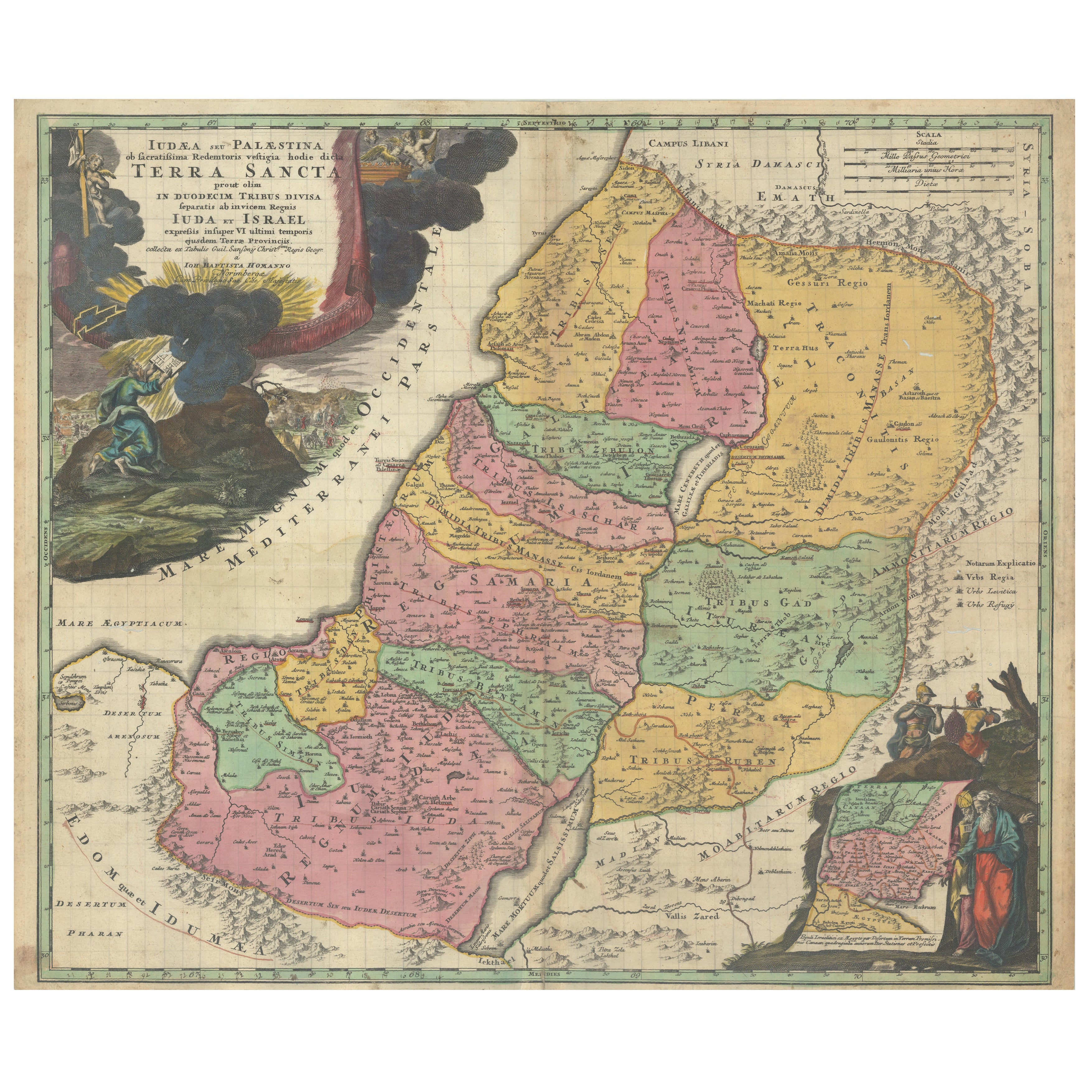
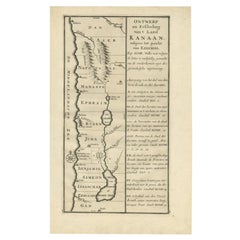
View AllHand-Colored Map of the Holy Land Divided Among the Twelve Tribes, c.1720
Located in Langweer, NL
Hand-Colored Map of the Holy Land Divided Among the Twelve Tribes, c.1720
This striking antique map, titled "Iudaea seu Palaestina ob Sacratissima Redemtoris Vestigia Hodie Dicta Te...
Category
Antique Early 18th Century German Maps
Materials
Paper

Antique Map of Northern Palestine with The Tribes of Israel. Dutch, 1763
Located in Langweer, NL
Antique Map of Northern Palestine with Tribal Divisions, Bachiene, 1763
The cartouche bears the title: “’t Noordelyke Gedeelte van het Geheel Palestina Benevens het Noordelyk en Zui...
Category
Antique 18th Century Dutch Maps
Materials
Paper
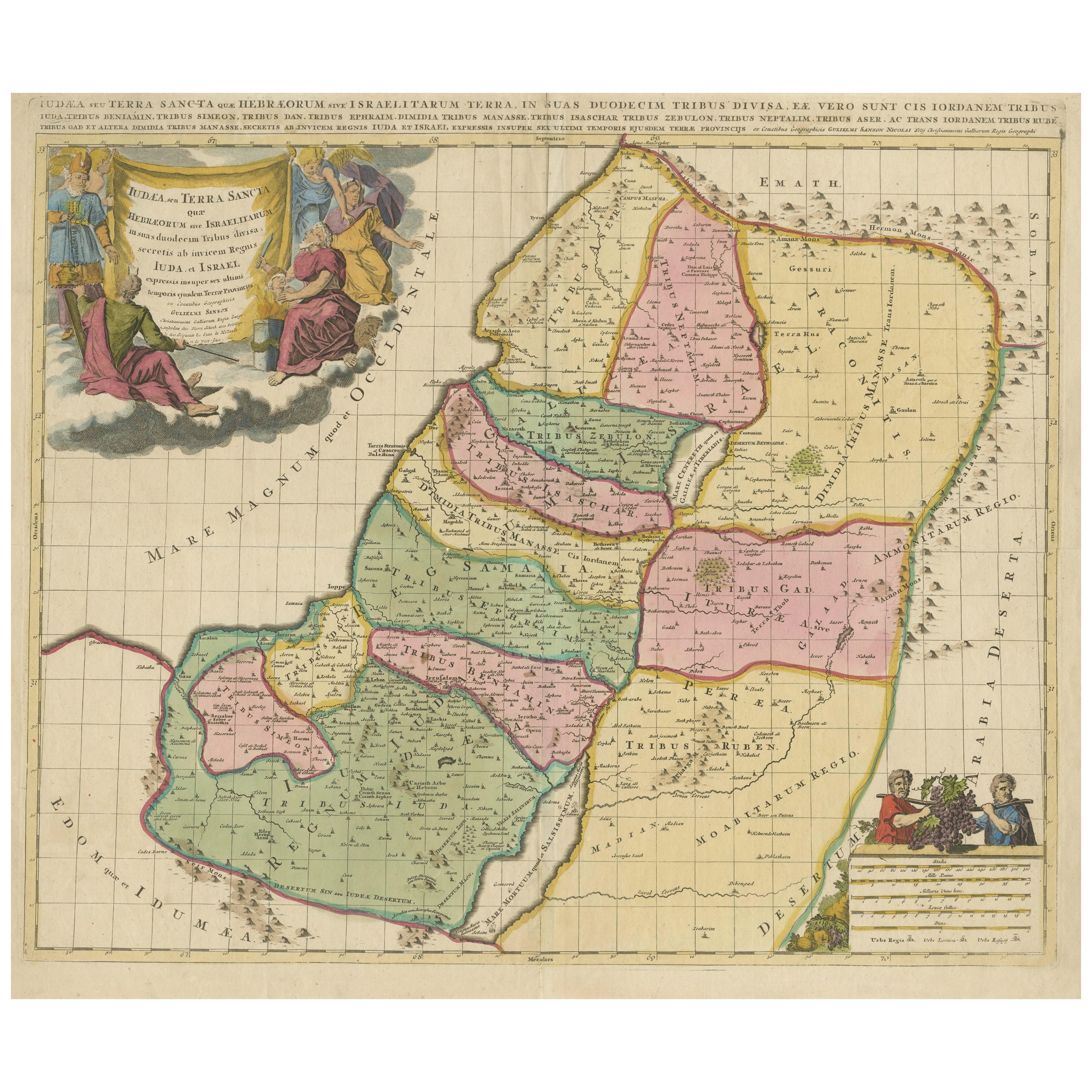
Judaea or Terra Sancta, Twelve Tribes of Israel – Sanson Map, c.1680
Located in Langweer, NL
Judaea or Terra Sancta, Twelve Tribes of Israel – Sanson Map, c.1680
This antique map depicts Judaea or the Holy Land divided among the Twelve Tribes of Israel, based on biblical ge...
Category
Antique Late 17th Century Dutch Maps
Materials
Paper
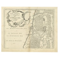
Antique Dutch Map of the Twelve Tribes of Israel – After Ezekiel, circa 1730
Located in Langweer, NL
Antique Dutch Map of the Twelve Tribes of Israel – After Ezekiel, circa 1730
This uncommon early 18th-century Dutch map is titled "Ontwerp en Erfdeeling van’t Land Kanaan, volgens h...
Category
Antique Early 18th Century Dutch Maps
Materials
Paper
Holy Land Map of the Twelve Tribes of Israel, After Sanson, Paris c.1798
Located in Langweer, NL
Holy Land, Twelve Tribes of Israel – After Nicolas Sanson, De Vaugondy / Delamarche, c.1798
Description:
Holy Land. De Vaugondy (G. R.), Carte de la Terre des Hébreux ou Israélites,...
Category
Antique Late 18th Century French Maps
Materials
Paper

Antique Holy Land Map, Twelve Tribes of Israel – Covens
Mortier, c.1700
Located in Langweer, NL
Antique Holy Land Map, Twelve Tribes of Israel – Covens
Mortier, c.1700
Description:
This finely engraved early 18th-century map depicts the Holy Land divided according to the...
Category
Antique Early 18th Century French Maps
Materials
Paper

You May Also Like
Southern Greece: A Large 17th Century Hand-colored Map By Sanson and Jaillot
By Nicholas Sanson d
Abbeville
Located in Alamo, CA
This large original hand-colored copperplate engraved map of southern Greece and the Pelopponese Peninsula entitled "La Moree Et Les Isles De Zante, Cefalonie, Ste. Marie, Cerigo & C...
Category
1690s Landscape Prints
Materials
Engraving

"Nova Barbariae Descriptio", a 17th Century Hand-Colored Map of North Africa
By Johannes Janssonius
Located in Alamo, CA
This original attractive 17th century hand-colored map of North Africa entitled "Nova Barbariae Descriptio" by Johannes Janssonius was published in Paris in 1635. It includes the Med...
Category
Antique Mid-17th Century Dutch Maps
Materials
Paper

$1,020 Sale Price
20% Off
North Holland, Netherlands: A Large 17th C. Hand-colored Map by Sanson
Jaillot
By Nicholas Sanson d
Abbeville
Located in Alamo, CA
This large hand-colored map entitled "Le Comte De Hollande Dressee sur les Memoires les plus Nouveaux" was originally created by Nicholas Sanson d'Abbeville. This version was publish...
Category
1690s Landscape Prints
Materials
Engraving

17th Century Hand Colored Map of the Liege Region in Belgium by Visscher
By Nicolaes Visscher II
Located in Alamo, CA
An original 17th century map entitled "Leodiensis Episcopatus in omnes Subjacentes Provincias distincté divisusVisscher, Leodiensis Episcopatus" by Nicolaes Visscher II, published in Amsterdam in 1688. The map is centered on Liege, Belgium, includes the area between Antwerp, Turnhout, Roermond, Cologne, Trier and Dinant.
This attractive map is presented in a cream-colored mat measuring 30" wide x 27.5" high. There is a central fold, as issued. There is minimal spotting in the upper margin and a tiny spot in the right lower margin, which are under the mat. The map is otherwise in excellent condition.
The Visscher family were one of the great cartographic families of the 17th century. Begun by Claes Jansz Visscher...
Category
Antique Late 17th Century Dutch Maps
Materials
Paper

$940 Sale Price
20% Off
Southern Greece: A Large 17th C. Hand-colored Map by Sanson and Jaillot
By Nicolas Sanson
Located in Alamo, CA
This large original hand-colored copperplate engraved map of southern Greece and the Pelopponese Peninsula entitled "La Moree Et Les Isles De Zante, Cefalonie, Ste. Marie, Cerigo & C...
Category
Antique 1690s French Maps
Materials
Paper

$1,580 Sale Price
20% Off
17th Century Dutch Map of the Holy Land at the Time of Jesus by Visscher
By Nicolaus Visscher
Located in Alamo, CA
This detailed Dutch map entitled "Het Beloofe de Landt Canaan door wandelt van onsen Salichmaecker Iesu Christo, nessens syne Apostelen" by Nicolaes Visscher (1610-1679), published i...
Category
1660s Prints and Multiples
Materials
Engraving

$1,020 Sale Price
20% Off
More Ways To Browse
Sea Of Galilee
Antique Victorian Dining Tables
Italian Plastic Chairs
Black Crystal Glasses
French Mid Century Modern Rug
China Silk Rug
Chrome Glass Coffee Tables
Antique Italian Chairs
Antique Walnut Bar
Beni Ourain Rugs
French Iron And Glass Table
Glass Top Wood Base Coffee Tables
T Chair
Antique Silver Basket
Antique Walkers
Ebony Wood Furniture
Opalescent Glass
Pair Of Danish Chairs