Items Similar to Hand-Colored Map of West India Islands: St. Christopher
s, St. Lucia and Nevis

Want more images or videos?
Request additional images or videos from the seller
1 of 6
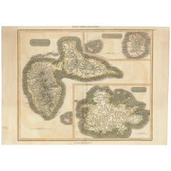
Hand-Colored Map of West India Islands: St. Christopher
s, St. Lucia and Nevis
$557.68
$697.1020% Off
£413.09
£516.3720% Off
€464
€58020% Off
CA$762.89
CA$953.6120% Off
A$831.51
A$1,039.3920% Off
CHF 439.61
CHF 549.5220% Off
MX$10,009.81
MX$12,512.2620% Off
NOK 5,579.77
NOK 6,974.7220% Off
SEK 5,115.51
SEK 6,394.3920% Off
DKK 3,535.42
DKK 4,419.2820% Off
About the Item
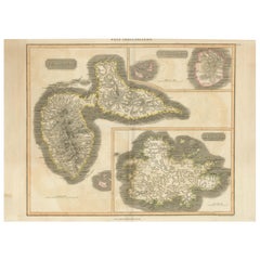
This map, titled "West India Islands," was published by John Thomson
Co. in 1821 as part of *Thomson's New General Atlas.* The map offers detailed depictions of three key islands in the West Indies on a single sheet: **St. Christopher's (St. Kitts), St. Lucia, and Nevis**. These maps are colored and beautifully rendered to reflect the geography of the islands during the early 19th century.
### Key Details:
- Publisher: J. Thomson
Co., Edinburgh
- Publication Year: 1821
- Language: English
- Media Type: Map
- Physical Size: The overall sheet measures approximately 51 x 62 cm.
### Features of the Map:
1. St. Christopher's (St. Kitts): This map shows detailed topography, including mountains, settlements, plantations, and key landmarks of the island. The coastline and features such as bays and points are clearly outlined.
2. St. Lucia: The map includes detailed geographic features of the island, with mountains, rivers, and other natural landmarks prominently marked. The surrounding coastline is also carefully detailed.
3. Nevis: This smaller island is shown in a detailed inset, including topographical features and the placement of major settlements and plantation areas.
### Significance:
The map is a valuable historical document, providing insight into the geographic knowledge and colonial interests of the British in the early 19th century. The attention to detail and hand-coloring make this map not only an informative tool but also a piece of decorative cartography from the period. The clear layout, combined with the presence of multiple maps on one sheet, makes it unique and practical for the time it was published.
This map would have been part of a larger atlas used for reference, showcasing the intricate mapping of the Caribbean islands and their importance to British maritime and colonial history.
- Dimensions:Height: 21.26 in (54 cm)Width: 28.94 in (73.5 cm)Depth: 0 in (0.02 mm)
- Materials and Techniques:Paper,Engraved
- Period:
- Date of Manufacture:1821
- Condition:Condition: good, given age. Overall light foxing. Vertical folds as issued. General age-related toning and/or occasional minor defects from handling. Please study scan carefully.
- Seller Location:Langweer, NL
- Reference Number:Seller: BG-13619-11stDibs: LU3054341730272
About the Seller
5.0
Recognized Seller
These prestigious sellers are industry leaders and represent the highest echelon for item quality and design.
Platinum Seller
Premium sellers with a 4.7+ rating and 24-hour response times
Established in 2009
1stDibs seller since 2017
2,813 sales on 1stDibs
Typical response time: 1 hour
- ShippingRetrieving quote...Shipping from: Langweer, Netherlands
- Return Policy
More From This Seller
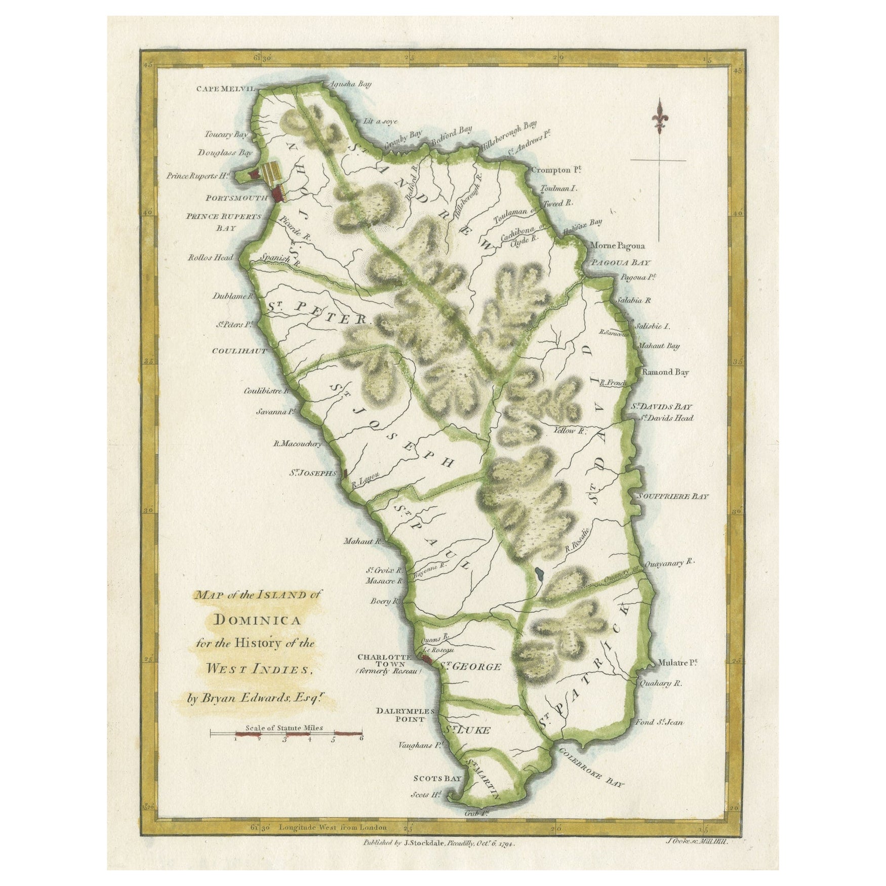
View AllOriginal Antique Map of the Island of Dominica in the West Indies, 1794
Located in Langweer, NL
MAP OF THE ISLAND OF DOMINICA for the History of the West Indies, by Bryan Edwards. Esq.
Dominica, an island renowned for its lucrative exports of sugar, cocoa, and coffee, operated...
Category
Antique 1790s Maps
Materials
Paper
$230 Sale Price
20% Off
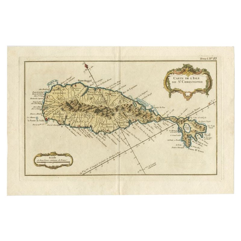
Old Map of the island of Saint Christopher or St. Kitts in the Caribbean, c.1765
Located in Langweer, NL
Antique map titled 'Carte de l'Isle de Saint-Christophe'.
A detailed map of the island of Saint Christopher or St. Kitts showing mountain ranges, port towns and parishes. This map ...
Category
Antique 18th Century Maps
Materials
Paper

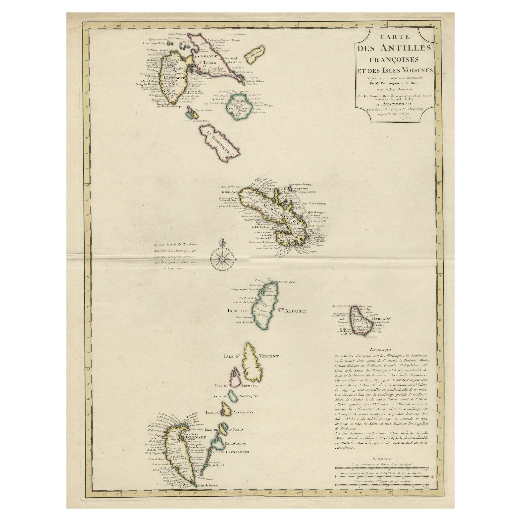
Detailed Antique Map of the Windward Islands in the Caribbean
By Covens
Mortier
Located in Langweer, NL
Antique map titled 'Carte des Antilles Francoises et des Isles Voisines'. Original antique map of the French Antilles, covering an area stretching from Guadeloupe in the north to Gre...
Category
Antique Early 18th Century Maps
Materials
Paper
$903 Sale Price
20% Off
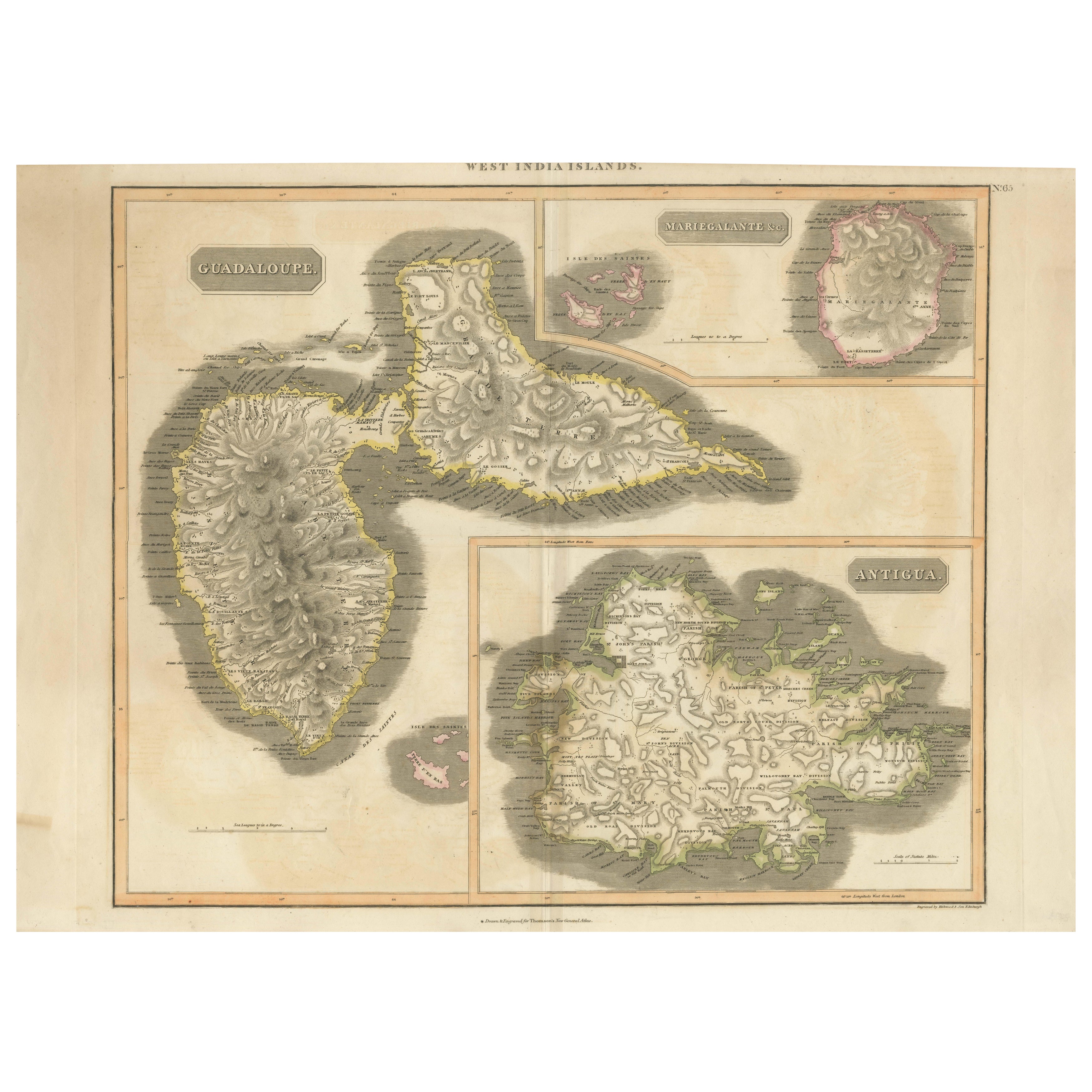
1821 Thomson Map of Guadeloupe, Marie-Galante and Antigua in the West Indies
Located in Langweer, NL
This map, published in 1821 by John Thomson, showcases Guadeloupe, Marie-Galante, and Antigua from the *West India Islands* collection. Part of Thomson's *New General Atlas*, it prov...
Category
Antique 1820s Maps
Materials
Paper
$557 Sale Price
20% Off
Large Antique Map of Guadeloupe and Antigua with Adjacent Isles, 19th Century
Located in Langweer, NL
Title: "Antique Map of Guadeloupe and Antigua with Adjacent Isles, 19th Century"
Source: New General Atlas (circa 1817), published in Edinburgh
Description: This detailed antique m...
Category
Antique Early 19th Century British Maps
Materials
Paper
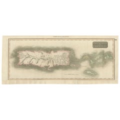
1817 Map of Puerto Rico and the Virgin Islands with Original Hand Coloring
Located in Langweer, NL
The title provided for this map is "Porto Rico and Virgin Isles," and it is an antique map from an early 19th century atlas, dated 1817, featuring original hand coloring. This histor...
Category
Antique Early 19th Century Maps
Materials
Paper
$355 Sale Price
20% Off
Free Shipping
You May Also Like
St. Christophe
St. Kitts
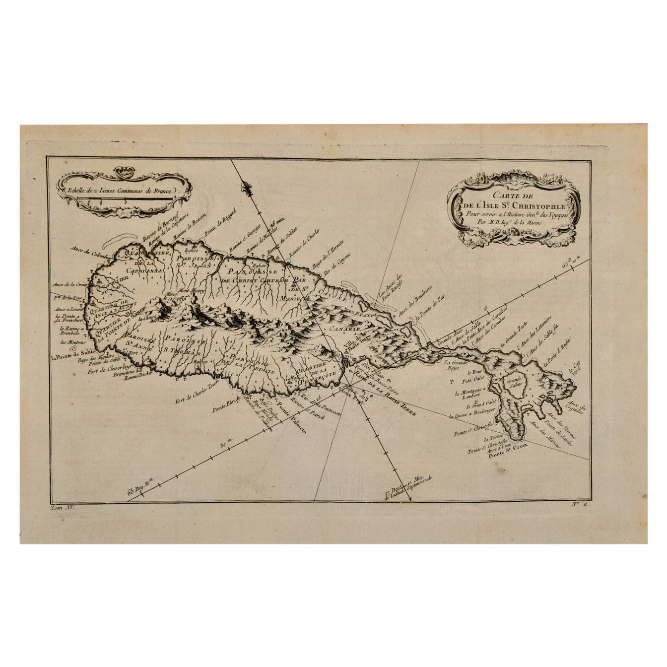
Island: An 18th Century Hand-colored Map by Bellin
By Jacques-Nicolas Bellin
Located in Alamo, CA
Jacques Bellin's copper-plate map of the Caribbean island of Saint Kitts entitled "Carte De De l'Isle St. Christophe Pour servir á l'Histoire Genle. des V...
Category
Antique Mid-18th Century French Maps
Materials
Paper

$460 Sale Price
20% Off
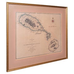
Antique St Christopher
Nevis Map, English, Caribbean Cartography, Georgian
Located in Hele, Devon, GB
This is a superb antique map of St Christopher and Nevis. An English, framed Caribbean island cartography engraving, dating to the Georgian period and later, circa 1780. A fascinatin...
Category
Antique 1780s British Georgian Maps
Materials
Glass, Paper
Captain Cook
s Exploration of Tahiti 18th C. Hand-Colored Map by Bellin
By Jacques-Nicolas Bellin
Located in Alamo, CA
This beautiful 18th century hand-colored copper plate engraved map is entitled "Carte de l'Isle de Taiti, par le Lieutenant J. Cook" was created by Jacques Nicolas Bellin and publish...
Category
Antique Mid-18th Century French Maps
Materials
Paper

$620 Sale Price
20% Off
St. Christophe (St. Kitts): Bellin 18th Century Hand Colored Map
Located in Alamo, CA
Jacques Bellin's copper-plate map of the Caribbean island of Saint Kitts entitled "Carte De De l'Isle St. Christophe Pour servir á l'Histoire Genle. des V...
Category
1740s Other Art Style Landscape Prints
Materials
Engraving

Large Original Antique Map of The West Indies by Sidney Hall, 1847
Located in St Annes, Lancashire
Great map of The West Indies
Drawn and engraved by Sidney Hall
Steel engraving
Original colour outline
Published by A & C Black. 1847
Unframed
Free shipping.
Category
Antique 1840s Scottish Maps
Materials
Paper

Large Original Antique Map of the The Windward Islands. 1894
Located in St Annes, Lancashire
Superb Antique map of The Windward Islands
Published Edward Stanford, Charing Cross, London 1894
Original colour
Good condition
Unframed.
Free shipping
Category
Antique 1890s English Maps
Materials
Paper

More Ways To Browse
St Christopher
18th Century Engravings
Antique Carved Wood Chair
Black Scandinavian Modern Dining Chairs
Dutch Mid Century Modern Table
Gold Modern Coffee Table
Iconic Modern Furniture
Midcentury Modern Gray Glass Vase
Round Glass Coffee Tables
Vintage Cave
18th Century Wood Side Tables
Antique Hand Carved Dining Room Sets
Mid Century Modern Pitcher
Vintage Italian Leather Dining Chair
Vintage Movie Posters
Blue Green Wool And Silk Rug
Brown Sheepskin Chair
Vintage Brass Bar Carts