Items Similar to Hand-Colored Map of Westphalia – Copper Engraving by Ottens, Amsterdam c.1720


Want more images or videos?
Request additional images or videos from the seller
1 of 11
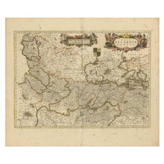
Hand-Colored Map of Westphalia – Copper Engraving by Ottens, Amsterdam c.1720
$673.06
£498.56
€560
CA$920.73
A$1,003.55
CHF 530.57
MX$12,080.80
NOK 6,734.21
SEK 6,173.89
DKK 4,266.89
About the Item
Hand-Colored Map of Westphalia – Copper Engraving by Ottens, Amsterdam c.1720
This striking early 18th-century map titled *Nova Ducatus Westphaliae Tabula accurate descripta et in Satrapis et Dynastias distincte divisa, Statibus Patriae* is a meticulously engraved and hand-colored representation of the Duchy of Westphalia and its neighboring territories. Published around 1720 by the renowned Amsterdam mapmakers Reinier and Josua Ottens, the map reflects the cartographic precision and artistic flair for which Dutch publishers were celebrated during the golden age of mapmaking.
Rendered in copper engraving and enhanced with contemporary hand-coloring, the map spans a wide swath of the Holy Roman Empire’s central-western regions, centering on what is now the German state of North Rhine-Westphalia. The political landscape is intricately divided into numerous satrapies and dynastic holdings, each outlined in yellow or red and filled in soft hues of green, pink, and ochre to distinguish the various jurisdictions and lordships.
An elaborate allegorical cartouche graces the lower right corner, depicting two classical figures symbolizing wisdom and governance, with heraldic emblems and decorative elements adding visual richness. Beneath them sits a finely engraved mileage scale, providing reference points for navigation and measurement. At the lower left, a key explains symbols used to indicate ecclesiastical authorities, imperial cities, and fortresses.
This map not only presents a detailed snapshot of early 18th-century political geography but also reflects the administrative complexity of the Holy Roman Empire at the time, with overlapping secular and ecclesiastical jurisdictions. The precision of engraving, clarity of labeling, and careful coloring make this both a valuable historical document and a superb decorative artifact.
Condition Report:
The map is in very good condition for a piece of this age. The paper is strong with only minor age-related toning along the central fold and margins. Original hand-coloring remains well preserved, with no fading or bleeding. There are no visible tears or repairs. Plate mark is clear, and the impression remains crisp and detailed.
Framing Tips:
This map deserves a classic and refined frame treatment. A dark walnut or black frame with gold inner edging will enhance its historical gravitas. A warm off-white or ivory mat will complement the original coloring and give space for the elaborate cartouche to stand out. UV-protective museum glass is strongly recommended to safeguard the delicate pigments and paper over time. This is an excellent piece for collectors of German regional maps or anyone seeking a sophisticated historical accent for their wall.
- Dimensions:Height: 18.71 in (47.5 cm)Width: 22.25 in (56.5 cm)Depth: 0.01 in (0.2 mm)
- Materials and Techniques:Paper,Engraved
- Place of Origin:
- Period:Early 17th Century
- Date of Manufacture:circa 1720
- Condition:The print is in good condition for its age. The original hand coloring remains vivid, with soft pinks, olives, and yellows highlighting the regional divisions. A centerfold is present as issued, with slight toning and light creases near the edge.
- Seller Location:Langweer, NL
- Reference Number:Seller: BG-13841-51stDibs: LU3054342667682
About the Seller
5.0
Recognized Seller
These prestigious sellers are industry leaders and represent the highest echelon for item quality and design.
Platinum Seller
Premium sellers with a 4.7+ rating and 24-hour response times
Established in 2009
1stDibs seller since 2017
2,811 sales on 1stDibs
Typical response time: 1 hour
- ShippingRetrieving quote...Shipping from: Langweer, Netherlands
- Return Policy
More From This Seller
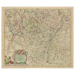
View AllRare Hand-Colored Map of Lyonnais Region in France by Frederik De Wit c. 1688
Located in Langweer, NL
Title: Rare Hand-Colored Map of Lyonnais Region by Frederik De Wit c. 1688
Description: This beautifully detailed map, "Gouvernement General du Lyonnois," showcases the Lyonnais reg...
Category
Antique 1680s Maps
Materials
Paper

Picardy Map - Hand-Colored 17th-Century Engraving by Frederik De Wit c. 1688
Located in Langweer, NL
Title: Picardy Map - Hand-Colored 17th-Century Engraving by Frederik De Wit c. 1688
Description: This beautifully detailed map, "Nova Picardiae Tabula," captures the Picardy region ...
Category
Antique 1680s Maps
Materials
Paper
Antique Map of Lotharingia (Lorraine) by Danckerts, c. 1700 – Hand-Colored
Located in Langweer, NL
Antique Map of Lotharingia (Lorraine) by Theodorus Danckerts circa 1700 Hand-Colored
This beautifully detailed antique map of Lotharingia, now the Lorraine region in northeastern ...
Category
Antique Early 1700s Maps
Materials
Paper
Rare Hand-Colored Map of Lorraine and Barrois, France by Frederik De Wit c. 1688
Located in Langweer, NL
Title: Rare Hand-Colored Map of Lorraine and Barrois by Frederik De Wit c. 1688
Description: This remarkable 17th-century map, titled "Generalis Lotharingiae Ducatus," offers a deta...
Category
Antique 1680s Maps
Materials
Paper

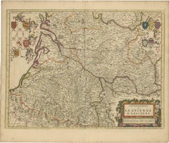
Gascogne and Guyenne Map - Hand-Colored 17th-Century Engraving by De Wit, c.1688
Located in Langweer, NL
Title: Gascogne and Guyenne Map - Hand-Colored 17th-Century Engraving by Frederik De Wit c. 1688
Description: This remarkable map, "Gouvernement de la Guyenne & Gascogne," captures ...
Category
Antique 1680s Maps
Materials
Paper
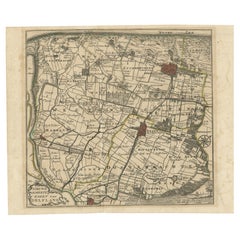
Hand-Colored Map of Delfland by Hendrik de Leth, 1740 – Delft
The Hague
Located in Langweer, NL
Hand-Colored Map of Delfland by Hendrik de Leth, 1740 – Delft & The Hague
This beautifully preserved antique map titled "Nieuwe Gemeete Kaert van Delfland" was engraved by Hendrik d...
Category
Antique 1740s Maps
Materials
Paper
You May Also Like
17th Century Hand-Colored Map of a Region in West Germany by Janssonius
By Johannes Janssonius
Located in Alamo, CA
This attractive highly detailed 17th century original hand-colored map is entitled "Archiepiscopatus Maghdeburgensis et Anhaltinus Ducatus cum terris adjacentibus". It was published ...
Category
Antique Mid-17th Century Dutch Maps
Materials
Paper

$1,020 Sale Price
20% Off
18th Century Hand-Colored Homann Map of Germany, Including Frankfurt and Berlin
By Johann Baptist Homann
Located in Alamo, CA
An 18th century hand-colored map entitled "Tabula Marchionatus Brandenburgici et Ducatus Pomeraniae quae sunt Pars Septentrionalis Circuli Saxoniae Superioris" by Johann Baptist Homa...
Category
Antique Early 18th Century German Maps
Materials
Paper

$620 Sale Price
20% Off
West Germany: Original Hand Colored 17th Century Map by Johannes Janssonius
By Johannes Janssonius
Located in Alamo, CA
An original hand colored copperplate engraved map entitled in Latin "Archiepiscopatus Maghdeburgensis et Anhaltinus Ducatus cum terris adjacentibus", published in Amsterdam in 1640 i...
Category
Mid-17th Century Old Masters More Prints
Materials
Engraving

17th Century Hand Colored Map of the Liege Region in Belgium by Visscher
By Nicolaes Visscher II
Located in Alamo, CA
An original 17th century map entitled "Leodiensis Episcopatus in omnes Subjacentes Provincias distincté divisusVisscher, Leodiensis Episcopatus" by Nicolaes Visscher II, published in Amsterdam in 1688. The map is centered on Liege, Belgium, includes the area between Antwerp, Turnhout, Roermond, Cologne, Trier and Dinant.
This attractive map is presented in a cream-colored mat measuring 30" wide x 27.5" high. There is a central fold, as issued. There is minimal spotting in the upper margin and a tiny spot in the right lower margin, which are under the mat. The map is otherwise in excellent condition.
The Visscher family were one of the great cartographic families of the 17th century. Begun by Claes Jansz Visscher...
Category
Antique Late 17th Century Dutch Maps
Materials
Paper

$940 Sale Price
20% Off
Hand Colored 18th Century Homann Map of Austria Including Vienna
the Danube
By Johann Baptist Homann
Located in Alamo, CA
"Archiducatus Austriae inferioris" is a hand colored map of Austria created by Johann Baptist Homann (1663-1724) and published in Nuremberg, Germany in 1728 shortly after his death. ...
Category
Early 18th Century Old Masters Landscape Prints
Materials
Engraving

Hand Colored 18th Century Homann Map of Austria Including Vienna and the Danube
By Johann Baptist Homann
Located in Alamo, CA
"Archiducatus Austriae inferioris" is a hand colored map of Austria created by Johann Baptist Homann (1663-1724) and published in Nuremberg, Germany in 1728 shortly after his death. ...
Category
Antique Early 18th Century German Maps
Materials
Paper

$540 Sale Price
20% Off
More Ways To Browse
17th Century Copper
Hand Colored Copper Engraving
Flair Holland
Blue Green Wool And Silk Rug
Brown Sheepskin Chair
Vintage Brass Bar Carts
Antique Botanical Prints
Green Persian Rug
50 X 50 Coffee Table
Milo Baughman 1970
Spanish Baroque Furniture
Stone China
Couch Console
Vintage Burn
Chinese Stone
Sterling Silver Flatware Service For 12
Antique Dining Tables With Leaves
Decorative Wall Panels