Items Similar to Hibernia Regnum Map by Carel Allard, 1700: Hand-Colored Provinces of Ireland

Want more images or videos?
Request additional images or videos from the seller
1 of 11
Hibernia Regnum Map by Carel Allard, 1700: Hand-Colored Provinces of Ireland
$1,993.42
$2,847.7430% Off
£1,488.18
£2,125.9730% Off
€1,680
€2,40030% Off
CA$2,769.46
CA$3,956.3730% Off
A$2,978.95
A$4,255.6430% Off
CHF 1,592.04
CHF 2,274.3430% Off
MX$35,113.29
MX$50,161.8530% Off
NOK 20,071.84
NOK 28,674.0630% Off
SEK 18,349.47
SEK 26,213.5330% Off
DKK 12,803.49
DKK 18,290.6930% Off
About the Item
This is a historical map of Ireland created by Carel Allard around 1700, titled "Hibernia Regnum in Quatuor Provincias Ultoniam, Connaciam, Lageniam, et Momoniam". The map is hand-colored and engraved. It includes two large decorative cartouches. The map is part of an atlas by Carel Allard, an Amsterdam-based cartographer.
Here are the detailed points about the map:
Maker: Carel Allard - a prominent Dutch cartographer and publisher from Amsterdam.
Atlas: Source Atlas - Likely part of an atlas published by Carel Allard, but specific title of the atlas isn't mentioned.
Interesting Features
1. Decorative Cartouches: The map features two large, ornate cartouches. One in the upper left depicts a classical figure and British Royal arms, while the lower right one is surrounded by allegorical figures and mythical creatures.
2. Hand Coloring: The map is noted for its exceptional hand coloring, adding to its decorative appeal.
3. Division of Provinces: It clearly delineates the four provinces of Ireland—Ulster (Ultonia), Connacht (Connacia), Leinster (Lagenia), and Munster (Momonia)—which are color-coded.
4. Historical Significance: The map is from around 1700, offering a glimpse into the cartographic knowledge and artistic styles of the early 18th century.
5. Condition: The map has a central horizontal fold and some marginal tears, but these have been professionally backed with thin paper, indicating its preservation and care.
Extra notes: The text in the lower left of the map is a dedication to Charles III,
This map is a valuable piece for collectors due to its rarity, decorative elements, and historical significance, especially considering the high quality of its coloring and the detailed depiction of Ireland’s provincial divisions.
- Dimensions:Height: 24.02 in (61 cm)Width: 20.4 in (51.8 cm)Depth: 0.01 in (0.2 mm)
- Materials and Techniques:Paper,Engraved
- Period:1700-1709
- Date of Manufacture:1700
- Condition:The map is in good condition with a central horizontal fold and a few small marginal tears, professionally backed with thin paper. Its exceptionally well-preserved hand coloring enhances its decorative and historical value.
- Seller Location:Langweer, NL
- Reference Number:Seller: BG-138081stDibs: LU3054340539242
About the Seller
5.0
Recognized Seller
These prestigious sellers are industry leaders and represent the highest echelon for item quality and design.
Platinum Seller
Premium sellers with a 4.7+ rating and 24-hour response times
Established in 2009
1stDibs seller since 2017
2,836 sales on 1stDibs
Typical response time: 1 hour
- ShippingRetrieving quote...Shipping from: Langweer, Netherlands
- Return Policy
More From This Seller
View AllDecorative Hand-Coloured Antique Map of the Four Irish Provinces, Ireland, c1718
Located in Langweer, NL
Title: Regni Hiberniae Accurata Tabula per Hermanum Moll
Decorative map of the four Irish provinces, Ireland, 1718, by Christoph Weigel (with credit to Herman Moll), engraved by Mi...
Category
Antique 1710s Maps
Materials
Paper
Irlandia – Antique Miniature Map of Ireland, Latin Cartography by Du Val c.1679
Located in Langweer, NL
Title: IRLANDIA – Antique Map of Ireland, Latin Cartography by Du Val c.1650
Description:
This original antique map depicts the island of Ireland under the Latin title “Irlandia” an...
Category
Antique Late 17th Century French Maps
Materials
Paper

Hand-colored Nautical Chart: St. George
s Channel and the Irish Sea, 1744
Located in Langweer, NL
The map was engraved by Richard William Seale, a notable British engraver. This map is a fine example of 18th-century cartography, particularly focused on maritime navigation.
The m...
Category
Antique 1740s Maps
Materials
Paper
$626 Sale Price
20% Off
Ireland Antique Map – Royaume d’Irlande, De Vaugondy, Venice 1778
Located in Langweer, NL
Antique Map of Ireland – Royaume d’Irlande, Robert de Vaugondy, Venice 1778
Description:
This finely engraved 18th-century map depicts the Kingdom of Ireland under the title Royaume d’Irlande divisé en ses quatre Provinces et subdivisé en Comtés. The island is shown in impressive detail, with the traditional four provinces—Ulster, Connaught, Leinster, and Munster—clearly delineated and subdivided into counties by contemporary outline coloring. Coastal features, rivers, towns, and road networks are rendered with the clarity and balance typical of late Enlightenment French cartography.
The map was drawn by Robert de Vaugondy, one of the most influential mapmakers of the 18th century and royal geographer to the King of France. This Venetian edition was published in 1778 by Paolo Santini, who issued a number of high-quality Italian editions of leading French cartographic works. Santini’s publications are prized for their crisp engraving, generous format, and restrained coloring, making them particularly attractive for framing.
The decorative maritime cartouche, left uncolored as issued, provides a refined visual counterbalance to the densely engraved map surface. Longitude and latitude scales frame the composition, while inset coastal details along the eastern seaboard emphasize Ireland’s maritime orientation and strategic importance during the Georgian period. The overall aesthetic is elegant rather than ornate, lending the map strong decorative appeal for both classic and contemporary interiors.
This map sits at the intersection of political geography and decorative cartography, reflecting Ireland’s administrative structure in the late 18th century while remaining visually calm and highly legible. It works exceptionally well as a stand-alone wall piece in libraries, studies, hallways, or heritage-inspired interiors, and also pairs beautifully with maps of England or Scotland from the same period.
Condition report:
Good antique condition. Light, even age toning throughout. Original centerfold as issued. Minor handling wear and soft creases consistent with age. Contemporary outline coloring well preserved. No major tears or losses.
Framing tips:
This map benefits from a wide mat to emphasize its scale and clarity. Recommended combinations include a dark walnut or ebonized frame with an ivory or light parchment mat for a traditional library look, or a slim black frame with an off-white mat for a cleaner, architectural presentation. UV glass is advised to preserve the original coloring.
Technique: Copper engraving with contemporary outline coloring
Maker: Robert de Vaugondy, published by Paolo Santini, Venice, 1778
Keywords:
antique map of Ireland, antique Ireland map, Royaume d’Irlande map, Robert de Vaugondy Ireland, Santini Venice map, 18th century Ireland map, hand colored antique map, Georgian era cartography, historic Ireland wall map, European antique map, French cartographic school, Italian engraved map, copper engraved map, decorative antique map, neutral antique wall art, classic library wall decor, historic wall decor, heritage interior art, gentleman’s library wall art, study wall decor, old world interior decor, English country house style, refined wall map, vintage European wall art, timeless wall decor, architectural interior art, framed antique map...
Category
Antique 1770s Italian Maps
Materials
Paper

Antique Map of the British Isles by H. Chatelain, 1719
By Henri-Abraham Chatelain
Located in Langweer, NL
Beautiful hand colored large format map of the British Isles, with large insets of the Eastern and Western Hemispheres and the coats of arms for Engl...
Category
Antique Early 18th Century Maps
Materials
Paper

Map of Ireland: Early 19th Century - from the 1802 Tardieu Atlas
Located in Langweer, NL
Antique Map Description
**Title:** Carte d'Irlande
**Publication Details:**
- **Atlas Title:** Nouvel Atlas Universel de Géographie Ancienne et Moderne
- **Purpose:** For the Nouve...
Category
Antique Early 1800s Maps
Materials
Paper

$417 Sale Price
20% Off
You May Also Like
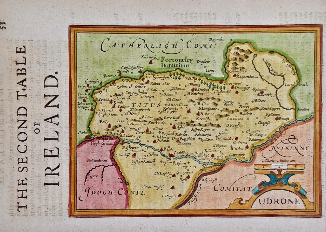
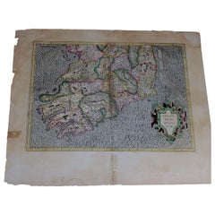
Southeastern Ireland: A 17th Century Hand Colored Map by Mercator and Hondius
By Gerard Mercator
Located in Alamo, CA
A 17th century copperplate hand-colored map entitled "The Second Table of Ireland, Udrone" by Gerard Mercator and Jodocus Hondius, published in Amsterdam in 1635 in 'Cosmographicall ...
Category
Antique Mid-17th Century Dutch Maps
Materials
Paper

Southeastern Ireland: A 17th Century Hand Colored Map by Mercator and Hondius
By Gerard Mercator
Located in Alamo, CA
A 17th century copperplate hand-colored map entitled "The Second Table of Ireland, Udrone" by Gerard Mercator and Jodocus Hondius, published in Amsterdam in 1635 in 'Cosmographicall ...
Category
1630s Landscape Prints
Materials
Engraving

Large Original Antique Map of Ireland. C.1900
Located in St Annes, Lancashire
Fabulous map of Ireland
Original color.
Engraved and printed by the George F. Cram Company, Indianapolis.
Published, C.1900.
Unframed.
Free shipping.
Category
Antique 1890s American Maps
Materials
Paper

1585 Mercator Map of Ireland, Entitled "Irlandiae Regnvm, " Hand Colored Ric0006
Located in Norton, MA
1585 Mercator map of Ireland, entitled
"Irlandiae Regnvm."
Hand Colored
Description: Published in Amsterdam by Mercator/Hondius ca. 1585.
Artists and Engravers: 1585 Mercator map of Ireland, entitled "Irlandiae Regnvm." Copperplate engraving on verge type hand laid paper with watermark. Description: Published in Amsterdam by Mercator/Hondius ca. 1585.Artists and Engravers: Mercator was born in Rupelmonde in Flanders and studied in Louvain under Gemma Frisius, Dutch writer, astronomer and mathematician. The excellence of his work brought him the patronage of Charles V, but in spite of his favor with the Emperor he was caught up in the persecution of Lutheran protestants and charged with heresy, fortunately without serious consequences. No doubt the fear of further persecution influenced his move in 1552 to Duisburg, where he continued the production of maps, globes and instruments. Mercator's sons and grandsons, were all cartographers and made their contributions in various ways to his atlas. Rumold, in particular, was responsible for the complete edition in 1595. The map plates...
Category
Antique 16th Century Dutch Maps
Materials
Paper
Large 17th Century Hand Colored Map of England and the British Isles by de Wit
By Frederick de Wit
Located in Alamo, CA
A large hand colored 17th century map of England and the British Isles by Frederick de Wit entitled "Accuratissima Angliæ Regni et Walliæ Principatus", published in Amsterdam in 1680. It is a highly detailed map of England, Scotland, the Scottish Isles...
Category
Antique Late 17th Century Dutch Maps
Materials
Paper

England, Scotland
Ireland: A Hand Colored Map of Great Britain by Tirion
By Isaak Tirion
Located in Alamo, CA
This is a hand-colored double page copperplate map of Great Britain entitled "Nieuwe Kaart van de Eilanden van Groot Brittannien Behelzende de Kon...
Category
Antique Mid-18th Century Dutch Maps
Materials
Paper

More Ways To Browse
1700 Antique Furniture
Pair Arm Chairs
Sterling Silver Dinner Sets
United Chair Company
Italian Beech Chairs
Shirvan Rugs
Vintage Danish Tables And Chairs
1960s Glass Top Coffee Table
Black Glass Coffee Tables
Burnt Wood
Mid Century Wrought Iron Chairs
Earth Toned Rug
Black Marble Table Vintage
Goblets
Mid Century Modern Yellow Chair
Paulin Pierre
Used Pianos Pianos
18th Century Engravings