Items Similar to Historical Map of the Black Sea and Surrounding Regions, 1705


Want more images or videos?
Request additional images or videos from the seller
1 of 7
Historical Map of the Black Sea and Surrounding Regions, 1705
$634.13
$792.6620% Off
£469.72
£587.1620% Off
€528
€66020% Off
CA$867.64
CA$1,084.5620% Off
A$944.06
A$1,180.0820% Off
CHF 499.87
CHF 624.8420% Off
MX$11,357.73
MX$14,197.1620% Off
NOK 6,347.24
NOK 7,934.0420% Off
SEK 5,807.28
SEK 7,259.0920% Off
DKK 4,023.79
DKK 5,029.7420% Off
About the Item
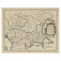
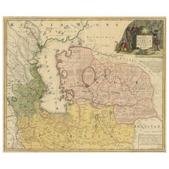
Title: "Map of Turcomania, Georgia, and Comania"
This print presents an intricately detailed map of the Caucasus region, titled “Turcomania, Georgien Commanie,” by the esteemed cartographer Nicolas Sanson. Published in 1705, the map's dimensions are 9.3 x 7.5 inches (23.6 x 19.1 cm) and it features hand-applied coloration, enhancing both its clarity and aesthetic appeal.
The map provides a comprehensive view of the geography of the Caucasus, with a focus on the areas known historically as Georgia, Armenia, and parts of Turkey and Iran, bordered by the Black and Caspian Seas. It includes depictions of significant cities, mountain ranges, and river systems, offering insight into the region's topography and settlements during the early 18th century.
A notable artistic element of the map is the ornate strapwork cartouche that graces the piece. This feature not only serves as a decorative title space but also contributes to the map's overall grandeur, reflecting the style and artistic conventions of the period.
The legacy of Nicolas Sanson's work is evident in the fact that his maps from "L'Asie en Plusieurs Cartes," originally published in 1652 and engraved by A. Peyrounin, were widely reproduced and adapted. These reproductions were undertaken by several map publishers, such as Johann David Zunners, Johannes Ribbius, and Simon de Vries, indicating the widespread influence and demand for Sanson's accurate and detailed cartographic representations.
The map's historical context is enriched by its journey through various hands and adaptations, with the engraving plates eventually being sold to Francois Halma. The titles on these maps were altered multiple times, translated into Dutch, and later reverted to French, reflecting the international interest in and utility of Sanson's cartography.
As a part of "Algemeene Weereld-Beschryving," this map is not only a geographic document but also a piece of art, which would have been prized by scholars, navigators, and collectors alike during the time of its production and remains a valuable historical artifact today.
- Dimensions:Height: 8.67 in (22 cm)Width: 11.89 in (30.2 cm)Depth: 0 in (0.02 mm)
- Materials and Techniques:Paper,Engraved
- Period:1700-1709
- Date of Manufacture:1705
- Condition:Very good. A dark and attractive impression on a bright sheet and a narrow top margin. Middle fold as issued. Study the scans carefully.`.
- Seller Location:Langweer, NL
- Reference Number:Seller: BG-137231stDibs: LU3054338603182
About the Seller
5.0
Recognized Seller
These prestigious sellers are industry leaders and represent the highest echelon for item quality and design.
Platinum Seller
Premium sellers with a 4.7+ rating and 24-hour response times
Established in 2009
1stDibs seller since 2017
2,816 sales on 1stDibs
Typical response time: 1 hour
- ShippingRetrieving quote...Shipping from: Langweer, Netherlands
- Return Policy
More From This Seller
View AllMap of Region Near the Baltic Sea, Present Day Bulgaria, Romania
Turkey, c1670
Located in Langweer, NL
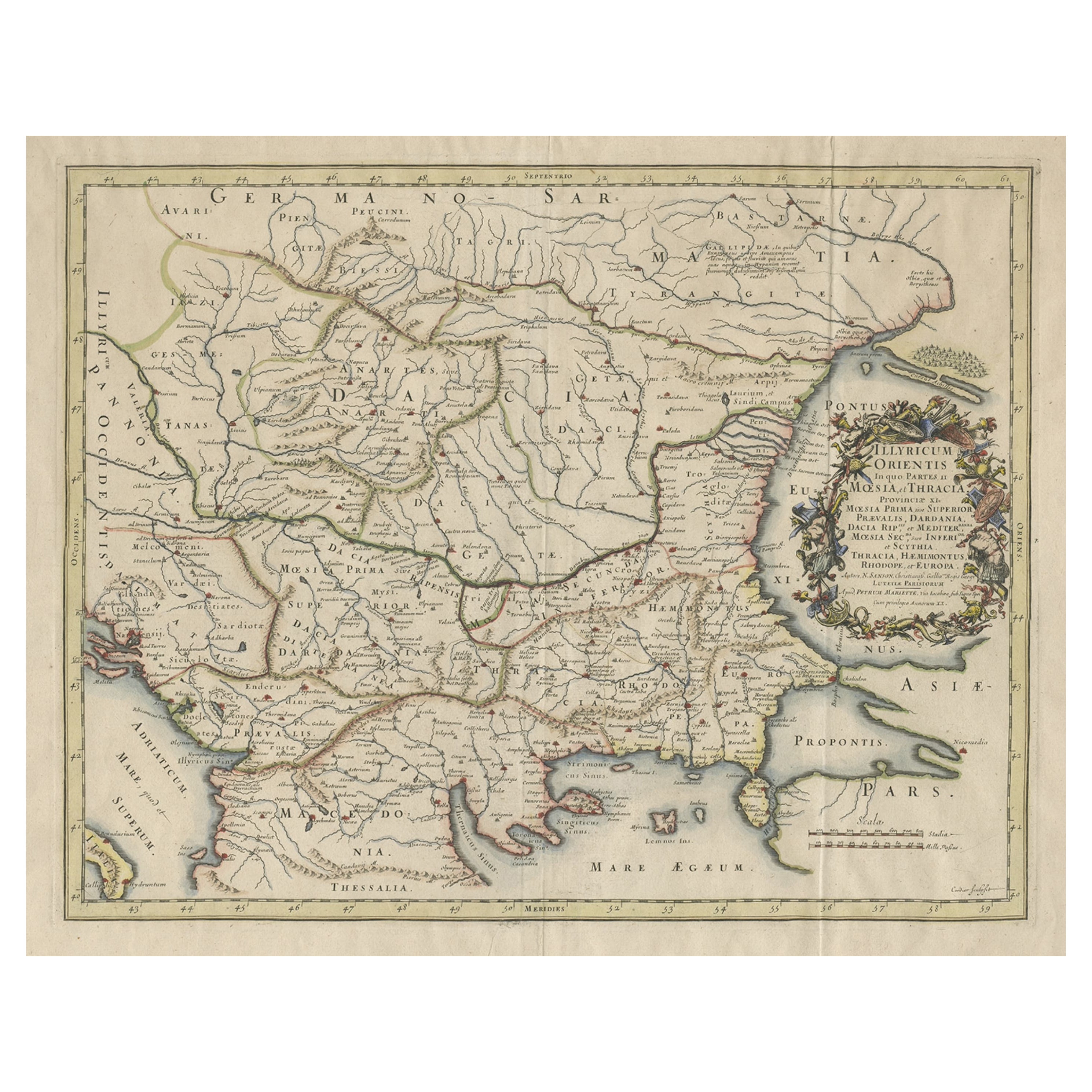
Antique map titled 'Illyricum Orientis: In quo Partes II Moesia et Thracia'.
Engraved map of the area west of the Baltic Sea, present day Bulgaria, Romania, and Turkey. The map i...
Category
Antique 1670s Maps
Materials
Paper
$1,297 Sale Price
20% Off
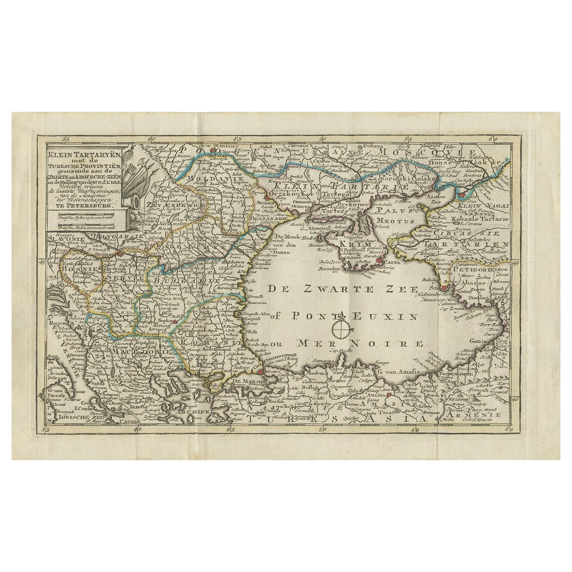
Antique Map of the Black Sea and Surroundings by Keizer
de Lat, 1788
Located in Langweer, NL
Antique map titled 'Klein Tartaryën met de Turksche Provintiën (..)'. Uncommon original antique map of the Black Sea and surroundings. This map originates from 'Nieuwe Natuur- Geschi...
Category
Antique Late 18th Century Maps
Materials
Paper
$336 Sale Price
20% Off
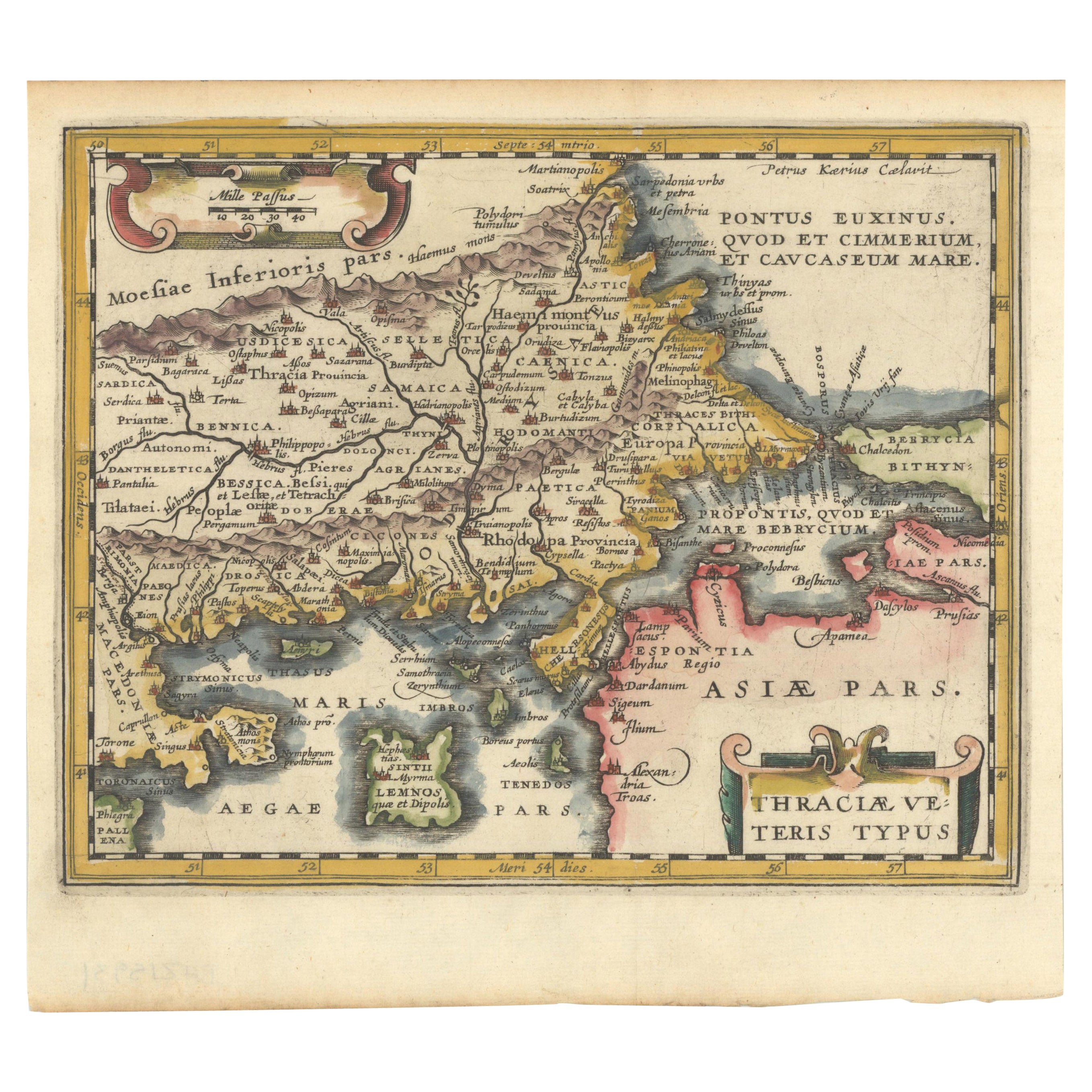
Original Old Map of Northeastern Greece
Northwestern Turkey, Published in 1661
Located in Langweer, NL
This small map was engraved by Petrus Kaerius and is based on Ortelius' map of the same title. It covers the ancient region of Thrace, present-day European Turkey and part of Greece....
Category
Antique 1660s Maps
Materials
Paper
$403 Sale Price
20% Off
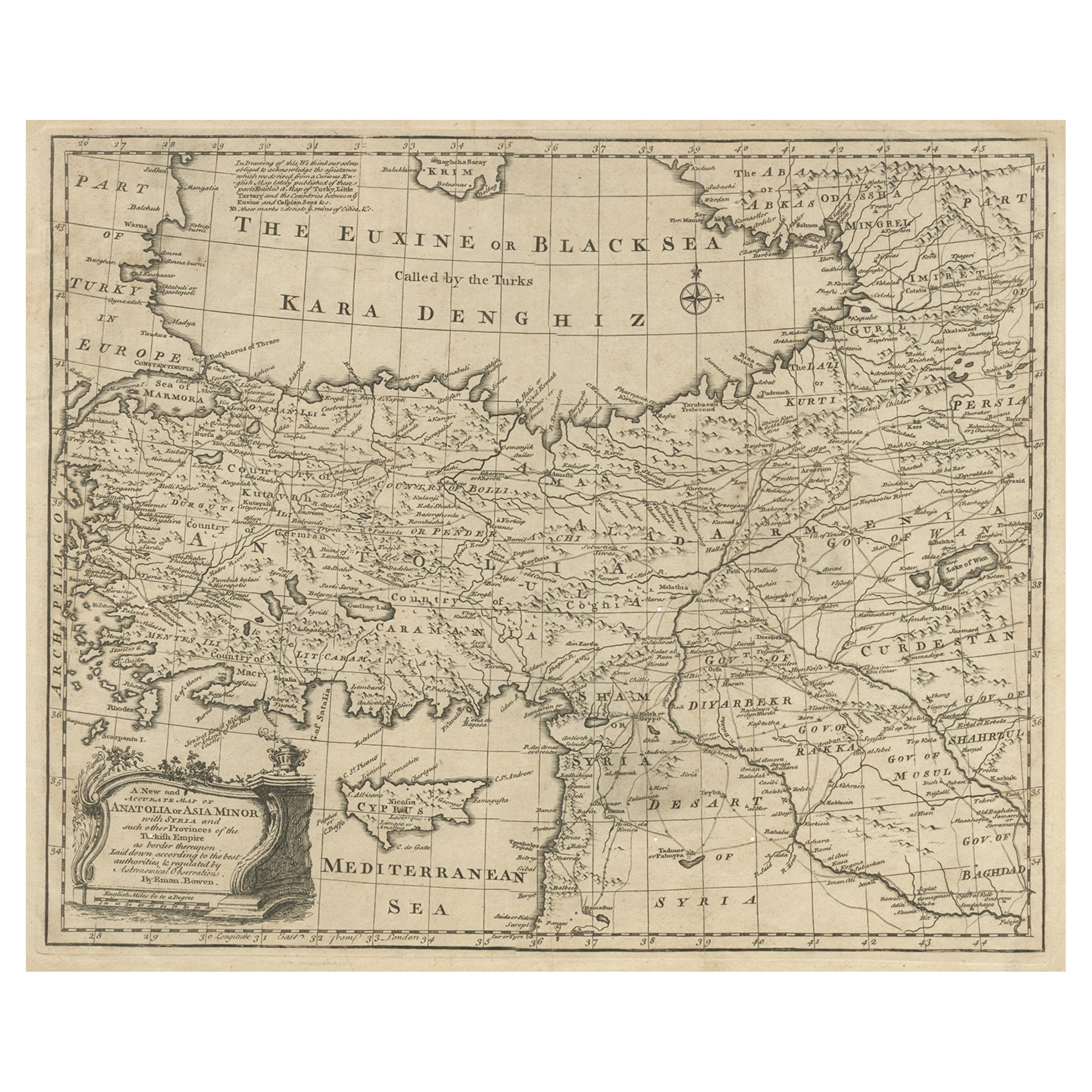
Antique Map of Asia Minor with Cyprus, Syria and Turkey and the Black Sea, 1747
Located in Langweer, NL
Antique map Middle East titled 'A New and accurate map of Anatolia or Asia Minor, with Syria and such other provinces of the Turkish Empire (.....
Category
Antique 18th Century Maps
Materials
Paper
Antique Map of the Caspian Sea, Uzbekistan, Northern Persia Etc, C.1735
Located in Langweer, NL
Antique map titled 'Nova Maris Caspii et Regions Usbeck (..).' Detailed map of Central Asia centered on the Caspian Sea, showing Uzbekistan to the east of ...
Category
Antique 18th Century Maps
Materials
Paper
Old Map of the Western Part of Central Europe, c.1680
Located in Langweer, NL
Antique map titled 'Carta nova accurate del Passagio et strada dalli Paesi Bassi'. Old map of the western portion of Central Europe. Oriented to the Northeast.
Artists and Engrav...
Category
Antique 17th Century Maps
Materials
Paper

You May Also Like
Southern Greece: A Large 17th C. Hand-colored Map by Sanson and Jaillot
By Nicolas Sanson
Located in Alamo, CA
This large original hand-colored copperplate engraved map of southern Greece and the Pelopponese Peninsula entitled "La Moree Et Les Isles De Zante, Cefalonie, Ste. Marie, Cerigo & C...
Category
Antique 1690s French Maps
Materials
Paper

$1,580 Sale Price
20% Off
17th Century Nicolas Visscher Map of Southeastern Europe
Located in Hamilton, Ontario
A beautiful, highly detailed map of southeastern Europe by Nicolas Visscher. Includes regions of Northern Italy (showing the cities Bologna, Padua, and Venice), Bohemia, Austria (sho...
Category
Antique 17th Century Dutch Maps
Materials
Paper

$1,350 Sale Price
38% Off
1633 Map Entitled "Beauvaisis Comitatus Belova Cium, Ric.0002
Located in Norton, MA
1633 map entitled
"Beauvaisis Comitatus Belova Cium,"
Hand Colored
Ric.0002
Description: Cartographer : - Hondius, Henricus 1587-1638
Artists and Engravers:Jodocus Hondius, one of the most notable engravers of his time. He is known for his work in association with many of the cartographers and publishers prominent at the end of the sixteenth and the beginning of the seventeenth century. A native of Flanders, he grew up in Ghent, apprenticed as an instrument and globe maker and map engraver. In 1584, to escape the religious troubles sweeping the Low Countries at that time, he fled to London where he spent some years before finally settling in Amsterdam about 1593. In the London period he came into contact with the leading scientists and geographers of the day and engraved maps in The Mariner\\\\\\\\\\\\\\\'s Mirrour, the English edition of Waghenaer\\\\\\\\\\\\\\\'s Sea Atlas, as well as others with Pieter van den Keere, his brother-in-law. No doubt his temporary exile in London stood him in good stead, earning him an international reputation, for it could have been no accident that Speed chose Hondius to engrave the plates for the maps in The Theatre of the Empire of Great Britaine in the years between 1605 and 1610. In 1604 Hondius bought the plates of Mercator\\\\\\\\\\\\\\\'s Atlas which, in spite of its excellence, had not competed successfully with the continuing demand for the Ortelius Theatrum Orbis Terrarum. To meet this competition Hondius added about 40 maps to Mercator\\\\\\\\\\\\\\\'s original number and from 1606 published enlarged editions in many languages, still under Mercator\\\\\\\\\\\\\\\'s name but with his own name as publisher. These atlases have become known as the Mercator/Hondius series. The following year the maps were reengraved in miniature form and issued as a pocket Atlas Minor. After the death of Jodocus Hondius the Elder in 1612, work on the two atlases, folio and miniature, was carried on by his widow and sons, Jodocus II and Henricus, and eventually in conjunction with Jan Jansson in Amsterdam.
In all, from 1606 onwards, nearly 50 editions with increasing numbers of maps with texts in the main European languages were printed. Summaries of these issues are given under the entry for Gerard Mercator. Jodocus Hondius the Elder * 1588 Maps in The Mariner\\\\\\\\\\\\\\\'s Mirrour (Waghenaer/Ashley) * 1590 World Map...
Category
Antique 17th Century Dutch Maps
Materials
Paper

Hand-Colored 18th Century Homann Map of the Black Sea, Turkey and Asia Minor
By Johann Baptist Homann
Located in Alamo, CA
An attractive original early 18th century hand-colored map of the Black Sea and Turkey entitled "Carte de L'Asie Minevre ou de la Natolie et du Pont Evxin Tiree des Voyages et des Ob...
Category
Antique Early 18th Century German Maps
Materials
Paper

$700 Sale Price
20% Off
Southern
Eastern Europe: A Large 17th C. Hand-colored Map by Sanson
Jaillot
By Nicolas Sanson
Located in Alamo, CA
This large hand-colored map entitled "Estats de L'Empire des Turqs en Europe, ou sont les Beglerbeglicz our Gouvernements" was originally created by Nicholas Sanson d'Abbeville and t...
Category
Antique 1690s French Maps
Materials
Paper

$1,740 Sale Price
20% Off
Prussia, Poland, N. Germany, Etc: A Hand-colored 17th Century Map by Janssonius
By Johannes Janssonius
Located in Alamo, CA
This is an attractive hand-colored copperplate engraved 17th century map of Prussia entitled "Prussia Accurate Descripta a Gasparo Henneberg Erlichensi", published in Amsterdam by Joannes Janssonius in 1664. This very detailed map from the golden age of Dutch cartography includes present-day Poland, Latvia, Lithuania, Estonia and portions of Germany. This highly detailed map is embellished by three ornate pink, red, mint green and gold...
Category
Antique Mid-17th Century Dutch Maps
Materials
Paper

$1,020 Sale Price
20% Off
More Ways To Browse
19th Century Round Dining Table
Carved Chinese Tables
Mid Century Modern Danish Teak Dining Tables
Long Rug Runners
Pair Arm Chairs
Sterling Silver Dinner Sets
United Chair Company
British Antiques
Italian Beech Chairs
Shirvan Rugs
Spain Marble
Vintage Brown Bottles
Vintage Danish Tables And Chairs
1960s Glass Top Coffee Table
Black Glass Coffee Tables
Burnt Wood
Mid Century Wrought Iron Chairs
Earth Toned Rug