Items Similar to Historical Map of Canaan with Insets of Jerusalem and Surrounding Regions, 1880

Want more images or videos?
Request additional images or videos from the seller
1 of 8
Historical Map of Canaan with Insets of Jerusalem and Surrounding Regions, 1880
$351.29
$439.1120% Off
£262.04
£327.5520% Off
€296
€37020% Off
CA$488.94
CA$611.1720% Off
A$524.54
A$655.6820% Off
CHF 281.35
CHF 351.6920% Off
MX$6,315.43
MX$7,894.2920% Off
NOK 3,546.80
NOK 4,433.5020% Off
SEK 3,234.19
SEK 4,042.7420% Off
DKK 2,255.75
DKK 2,819.6820% Off
About the Item
The map titled "CANAAN" depicts the historical region known as Canaan, located in the Levant, which corresponds to modern-day Israel, Palestinian territories, Lebanon, and parts of Syria and Jordan.
Key features include:
1. **Historical Territories**: It details the territories of the ancient Canaanite people and the subsequent Israelite tribes.
2. **Geographical Features**: The map shows the eastern Mediterranean coastline, the Jordan River, the Dead Sea, and other significant topographical features like mountain ranges and valleys.
3. **Inset Maps**: There are inset maps that provide a detailed view of important locations, such as Jerusalem, with key historical and biblical sites marked.
4. **Ancient Cities**: Cities such as Jericho, Hebron, and others are likely indicated, reflecting their importance in ancient times.
5. **Cultural and Political Boundaries**: The boundaries of the map might reflect the political divisions during different periods, such as the time of the Canaanites, the Judges, or the united and divided monarchy of Israel.
6. **Archaeological and Historical Sites**: The map may also mark locations of archaeological significance or areas mentioned in biblical and historical texts.
This map would hold interest for those studying the ancient Near East, biblical history, archaeology, and the historical geography of the region. It represents the area during a period that could range from the late Bronze Age to the Iron Age when Canaan was a hub of various cultural and political activities.
This map is from the "Spruner-Menke Atlas Antiquus," a historical atlas compiled by German cartographer Karl Spruner von Merz and later edited by Theodorus Menke. The atlas is known for its detailed maps of the ancient world, intended for educational and scholarly use, and was published in the late 19th century.
- Dimensions:Height: 15.56 in (39.5 cm)Width: 18.51 in (47 cm)Depth: 0 in (0.02 mm)
- Materials and Techniques:
- Period:
- Date of Manufacture:1880
- Condition:Good, given age. General age-related toning, especially around the edges. vertical folding line as issued. Please study scan carefully.
- Seller Location:Langweer, NL
- Reference Number:Seller: BG-13686-2-221stDibs: LU3054338557692
About the Seller
5.0
Recognized Seller
These prestigious sellers are industry leaders and represent the highest echelon for item quality and design.
Platinum Seller
Premium sellers with a 4.7+ rating and 24-hour response times
Established in 2009
1stDibs seller since 2017
2,830 sales on 1stDibs
Typical response time: 1 hour
- ShippingRetrieving quote...Shipping from: Langweer, Netherlands
- Return Policy
More From This Seller
View AllPalestine
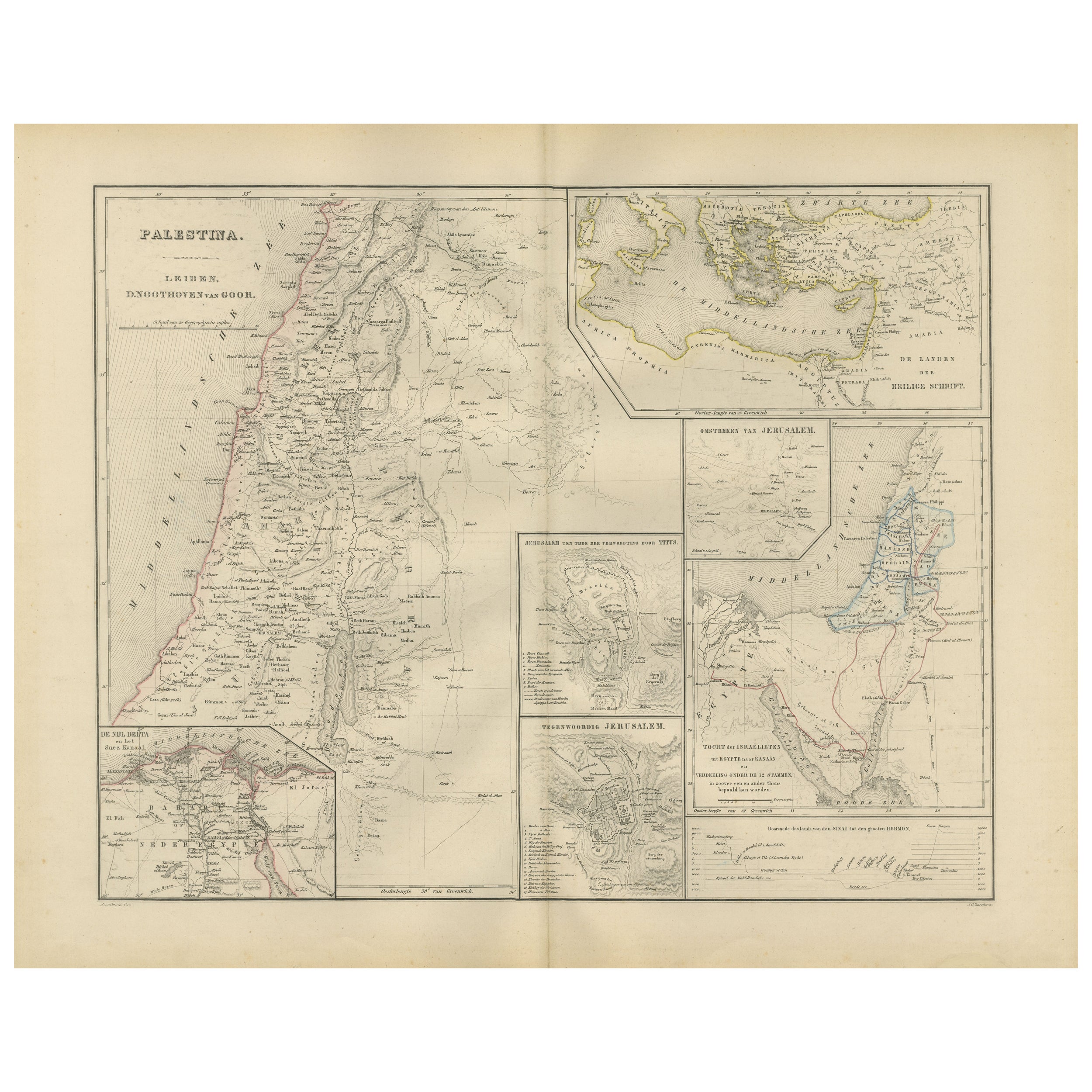
Holy Land Map with Jerusalem Insets – Nieuwe Hand-Atlas, 1876
Located in Langweer, NL
Palestine & Holy Land Map with Jerusalem Insets – Nieuwe Hand-Atlas, 1876
This detailed 19th-century map titled “Palestina” offers a comprehensive cartographic portrait of the Holy ...
Category
Antique 1870s Dutch Maps
Materials
Paper
Antique Map of Egypt and Palestina by H. Kiepert, circa 1870
By Heinrich Kiepert
Located in Langweer, NL
Antique map titled 'Aegyptus, Phoenice et Palestina'. With inset maps of Tyrus, Alexandria and Hierosolyma. This map originates from 'Atlas Antiquus. Zwölf Karten zur Alten Geschicht...
Category
Antique Late 19th Century German Maps
Materials
Paper

$151 Sale Price
20% Off
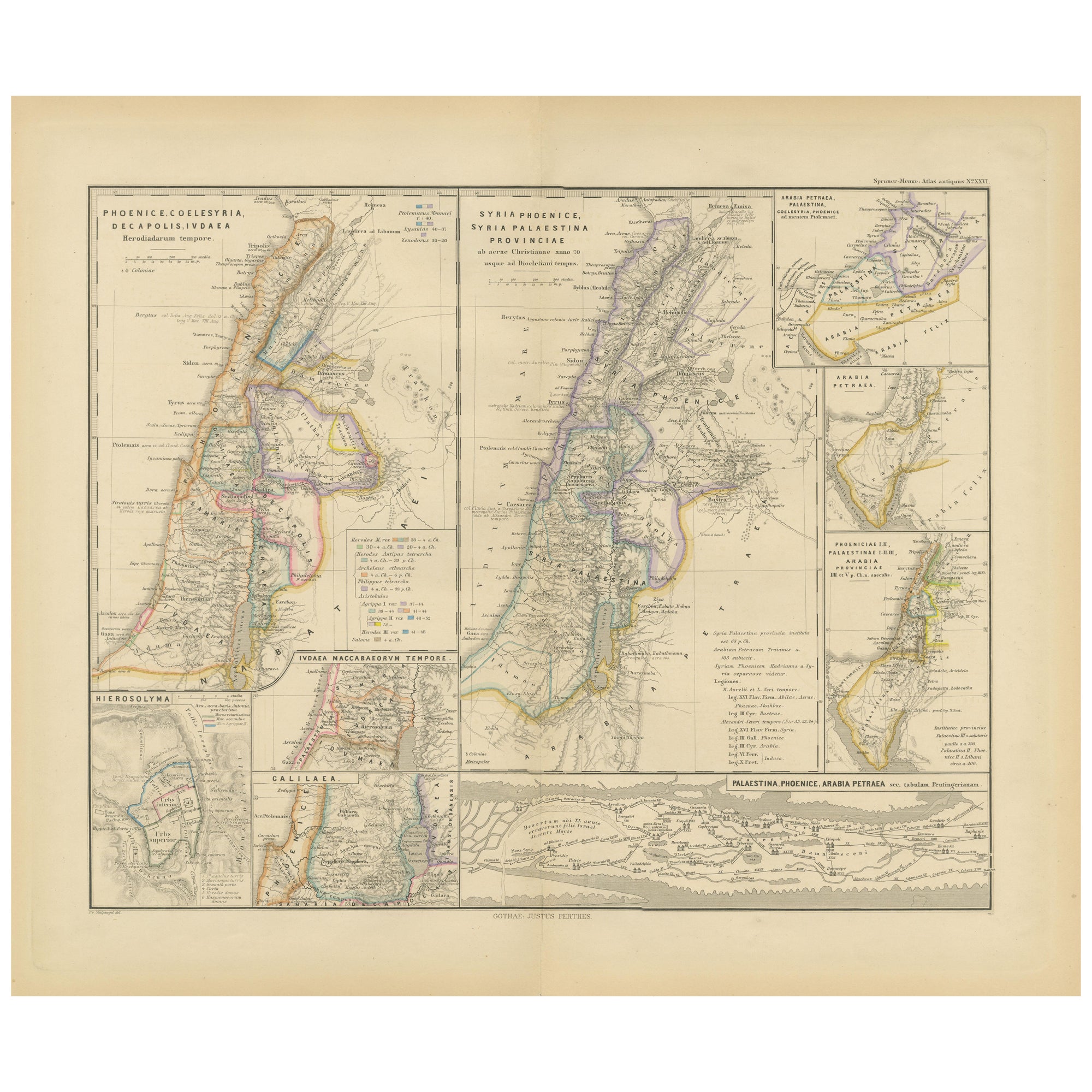
Levant in Antiquity: Lands of Phoenicia, Judea, and Neighboring Kingdoms, 1880
Located in Langweer, NL
The map is titled "PHOENICE, COELESYRIA, IDUMAEA, JUDAEA MACCABAEORUM TEMPORE," which translates to "Phoenicia, Coele-Syria, Idumea, Judea at the Time of the Maccabees."
This origi...
Category
Antique 1880s Maps
Materials
Paper
$351 Sale Price
20% Off
Free Shipping
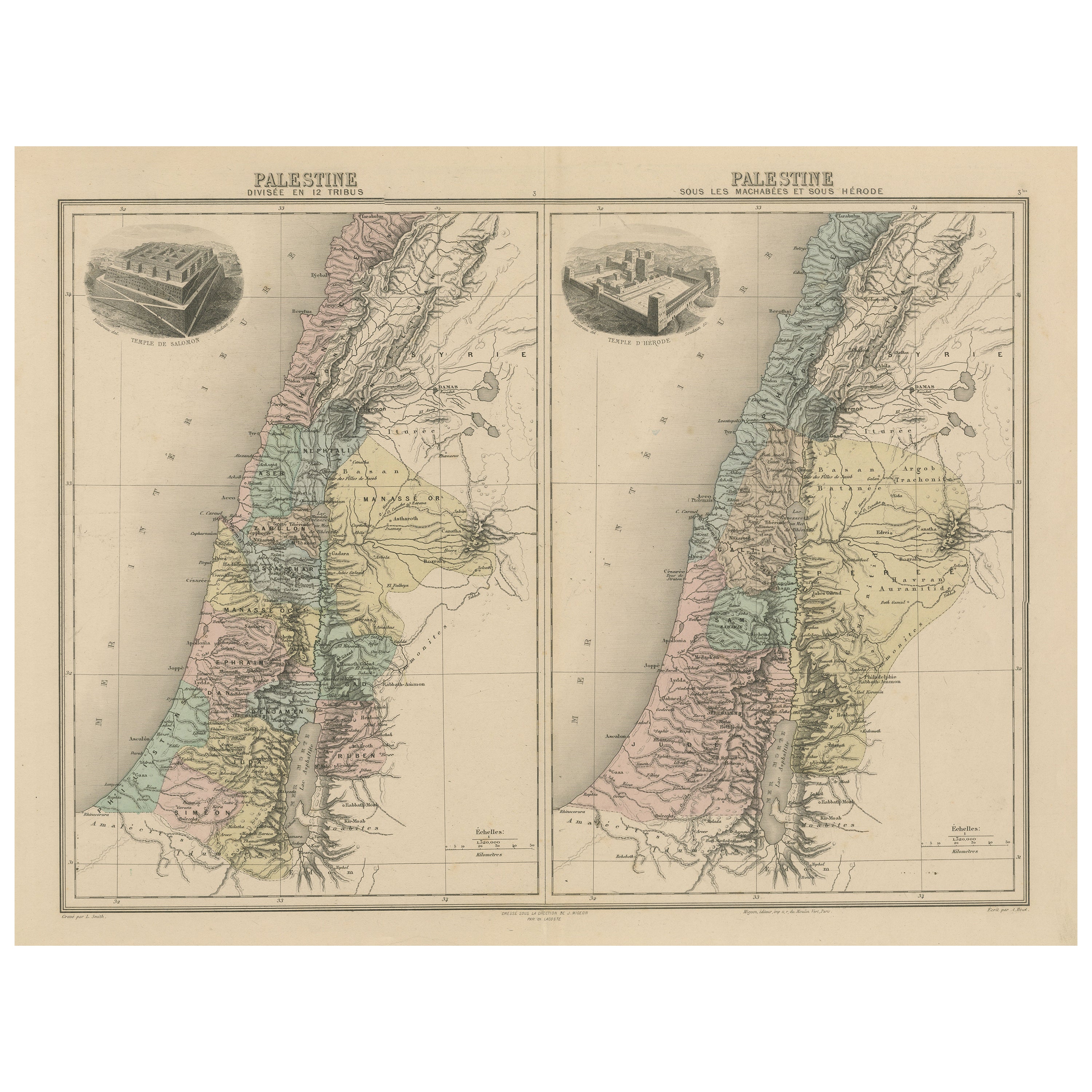
Palestine: Tribes
Maccabees – Antique Map by Migeon, Paris, 1892
Located in Langweer, NL
Palestine Divided into Tribes & Under the Maccabees – Antique Map by Migeon, 1892
This detailed antique map features two historical views of the Holy Land side by side: Palestine di...
Category
Antique Late 19th Century Maps
Materials
Paper
$322 Sale Price
20% Off
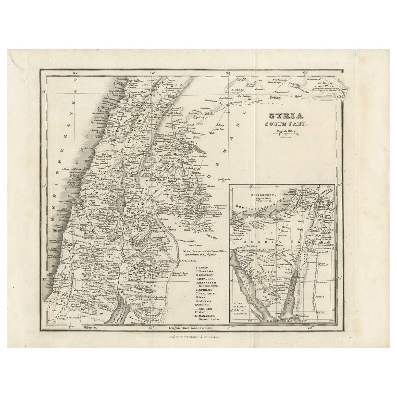
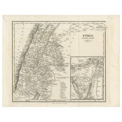
Antique Map of Southern Syria by Fullarton
Co, circa 1860
Located in Langweer, NL
Antique map titled 'Syria south part'. Published by Fullarton & Co, Glasgow, circa 1860.
- Title: Syria South Part
- Publisher: Fullarton & Co, Glasgow
- Date of Publication: Circa ...
Category
Antique Mid-19th Century English Maps
Materials
Paper
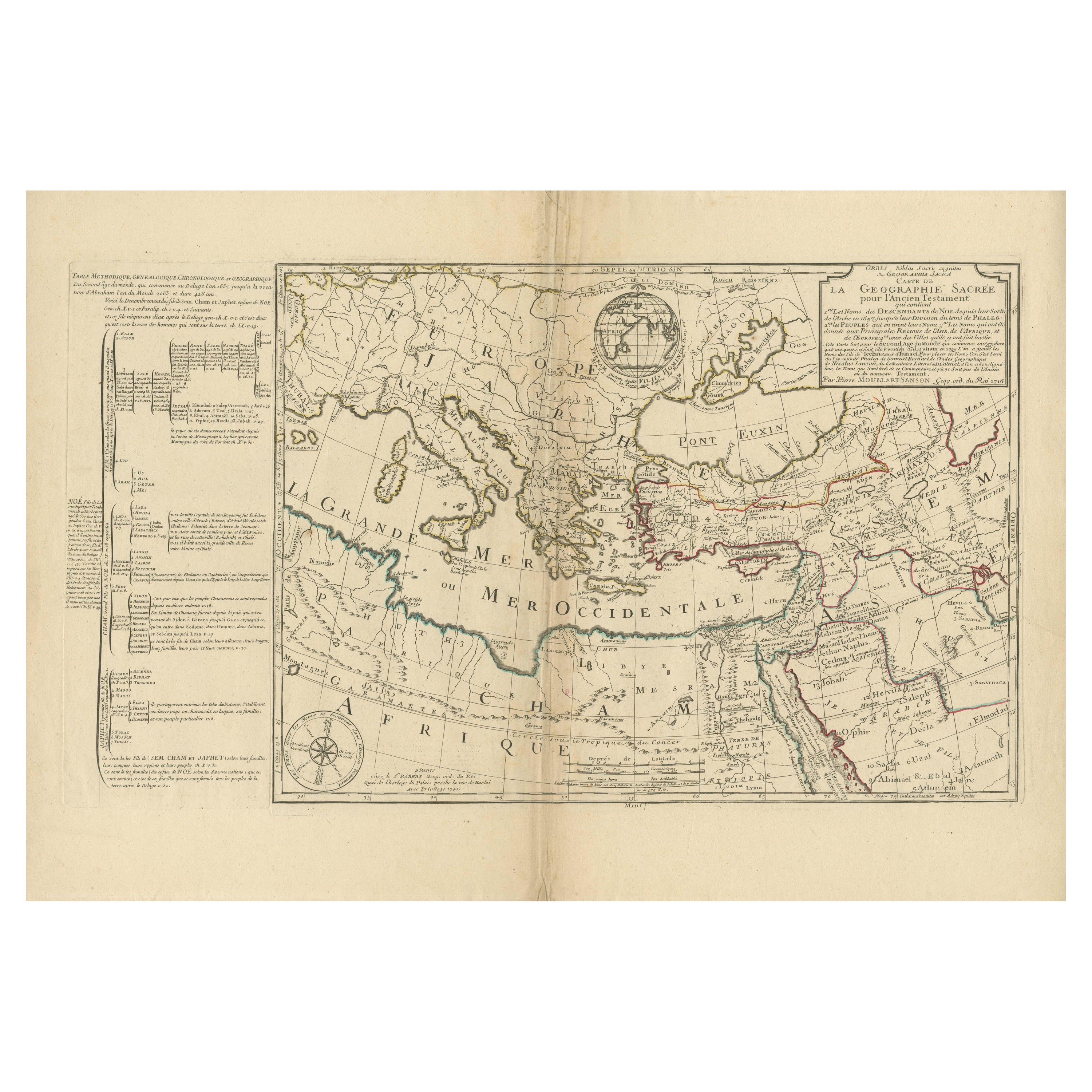
Moullart-Sanson Map of the Holy Land and Sacred Geography of the Old Testament
Located in Langweer, NL
"1716 Moullart-Sanson Map of the Holy Land and Sacred Geography of the Old Testament"
This engraved map, created by Pierre Moullart-Sanson and reissued by Robert de Vaugondy in 1740...
Category
Antique 1710s Maps
Materials
Paper
You May Also Like
Large Original Vintage Map of Israel, circa 1920
Located in St Annes, Lancashire
Great map of Israel
Original color.
Good condition
Published by Alexander Gross
Unframed.
Category
Vintage 1920s English Edwardian Maps
Materials
Paper

Map of the Holy Land "Carte de la Syrie et de l
Egypte" by Pierre M. Lapie
By Pierre M. Lapie
Located in Alamo, CA
An early 19th century map of ancient Syria and Egypt entitled "Carte de la Syrie et de l'Egypte anciennes/dressée par M. Lapie, Colonel d'Etat Major, et...
Category
Antique Early 19th Century French Maps
Materials
Paper

Map of the Holy Land "Carte de la Syrie et de l
Egypte" by Pierre Lapie
By Pierre M. Lapie
Located in Alamo, CA
This is an early 19th century map of ancient Syria and Egypt entitled "Carte de la Syrie et de l'Egypte anciennes/dressée par M. Lapie, Colonel d'Etat M...
Category
1830s Landscape Prints
Materials
Engraving

Original Antique Decorative Map of South America-West Coast, Fullarton, C.1870
Located in St Annes, Lancashire
Great map of Chili, Peru and part of Bolivia
Wonderful figural border
From the celebrated Royal Illustrated Atlas
Lithograph. Original color.
Published by Fullarton, Edi...
Category
Antique 1870s Scottish Maps
Materials
Paper

Circa 1825 original engraving of the map of Syria by Giraldon Bovinet
Located in PARIS, FR
The circa 1825 original engraving of "Syrie" by Giraldon Bovinet, based on the work of L. Vivien, is a historically significant map that reflects early 19th-century cartographic tech...
Category
1820s Prints and Multiples
Materials
Paper, Engraving

Africa. North-West Part. Century Atlas antique vintage map
Located in Melbourne, Victoria
'The Century Atlas. Africa. Southern Part'
Original antique map, 1903.
Central fold as issued. Map name and number printed on the reverse corners.
Sheet 40cm by 29.5cm.
Category
Early 20th Century Victorian More Prints
Materials
Lithograph

More Ways To Browse
19th Century Round Dining Table
Carved Chinese Tables
Mid Century Modern Danish Teak Dining Tables
Long Rug Runners
Pair Arm Chairs
Sterling Silver Dinner Sets
United Chair Company
British Antiques
Italian Beech Chairs
Shirvan Rugs
Spain Marble
Vintage Brown Bottles
Vintage Danish Tables And Chairs
1960s Glass Top Coffee Table
Black Glass Coffee Tables
Burnt Wood
Mid Century Wrought Iron Chairs
Earth Toned Rug