Items Similar to Historical Map of the Duchy of Lauenburg by Johann Baptist Homann - Circa 1720


Want more images or videos?
Request additional images or videos from the seller
1 of 10
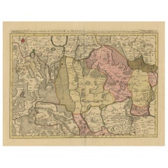
Historical Map of the Duchy of Lauenburg by Johann Baptist Homann - Circa 1720
$649.03
£480.76
€540
CA$887.85
A$967.71
CHF 511.62
MX$11,649.34
NOK 6,493.70
SEK 5,953.40
DKK 4,114.50
About the Item
Historical Map of the Duchy of Lauenburg by Johann Baptist Homann - Circa 1720
This splendid historical map titled Ducatus Lauemburgicus is a highly detailed and beautifully engraved copperplate map produced by Johann Baptist Homann around 1720. The map showcases the Duchy of Lauenburg (Lauenburg in present-day Schleswig-Holstein, Germany) and its surroundings, offering a comprehensive and precise depiction of the region during the early 18th century.
Johann Baptist Homann, one of the most prominent German cartographers of his time, created this map with meticulous attention to detail, reflecting the geographical and political landscape of the Duchy of Lauenburg and adjacent areas. The map is hand-colored in rich, old hues of pink, yellow, and green, highlighting various territorial divisions and duchies. The strong, contrasting colors provide clarity to the intricate borders and subdivisions, emphasizing the diverse political entities present at that time.
An inset map in the upper left corner, labeled Hadelorum Regio, provides a closer view of the region around Stade and Buxtehude, highlighting additional administrative details. The use of inset maps to provide detailed regional views was a hallmark of Homann’s cartographic style, showcasing his dedication to accuracy and thorough representation.
One of the most captivating elements of this map is the richly ornate cartouche located in the lower left corner. This cartouche exemplifies the baroque style, featuring mythological figures, regal symbolism, and heraldic elements. A prominent armored warrior stands beside a pedestal inscribed with the title, while allegorical figures, including a reclining river god and putti, add artistic flair and grandeur. The symbolism of strength and authority reflects the noble heritage of the Duchy of Lauenburg.
The map’s detailed engraving captures natural features such as rivers, forests, and settlements with remarkable precision. The inclusion of numerous towns, villages, and geographic landmarks highlights the cartographer’s extensive knowledge and dedication to accuracy. Homann’s mastery of the copperplate engraving technique is evident in the finely etched lines and precise topographic details.
This map not only serves as a valuable historical document but also as an artistic masterpiece of 18th-century cartography. Collectors and enthusiasts appreciate its combination of geographical accuracy and elaborate visual elements, making it an enduring symbol of European cartographic heritage.
Condition: The map is in good condition with strong, vibrant coloring and minimal signs of aging, mostly around the edges. Some slight age toning and faint creases are present but do not detract from the aesthetic appeal. The paper remains sturdy, and the engraving is sharp and clear.
Framing Tips: To preserve and enhance the presentation of this historical map, choose a classic wooden frame in a dark walnut or mahogany finish, complemented by a cream or light tan mat. Use UV-protective, non-reflective glass to prevent fading and glare, ensuring long-lasting preservation and optimal display.
- Dimensions:Height: 24.53 in (62.3 cm)Width: 20.75 in (52.7 cm)Depth: 0.01 in (0.2 mm)
- Materials and Techniques:Paper,Engraved
- Period:1720-1729
- Date of Manufacture:circa 1720
- Condition:good condition with strong, vibrant coloring and minimal signs of aging, mostly around the edges. Some slight age toning and faint creases are present but do not detract from the aesthetic appeal. The paper remains sturdy, and the engraving is sharp.
- Seller Location:Langweer, NL
- Reference Number:Seller: BG-13842-251stDibs: LU3054344169052
About the Seller
5.0
Recognized Seller
These prestigious sellers are industry leaders and represent the highest echelon for item quality and design.
Platinum Seller
Premium sellers with a 4.7+ rating and 24-hour response times
Established in 2009
1stDibs seller since 2017
2,813 sales on 1stDibs
Typical response time: 1 hour
- ShippingRetrieving quote...Shipping from: Langweer, Netherlands
- Return Policy
More From This Seller
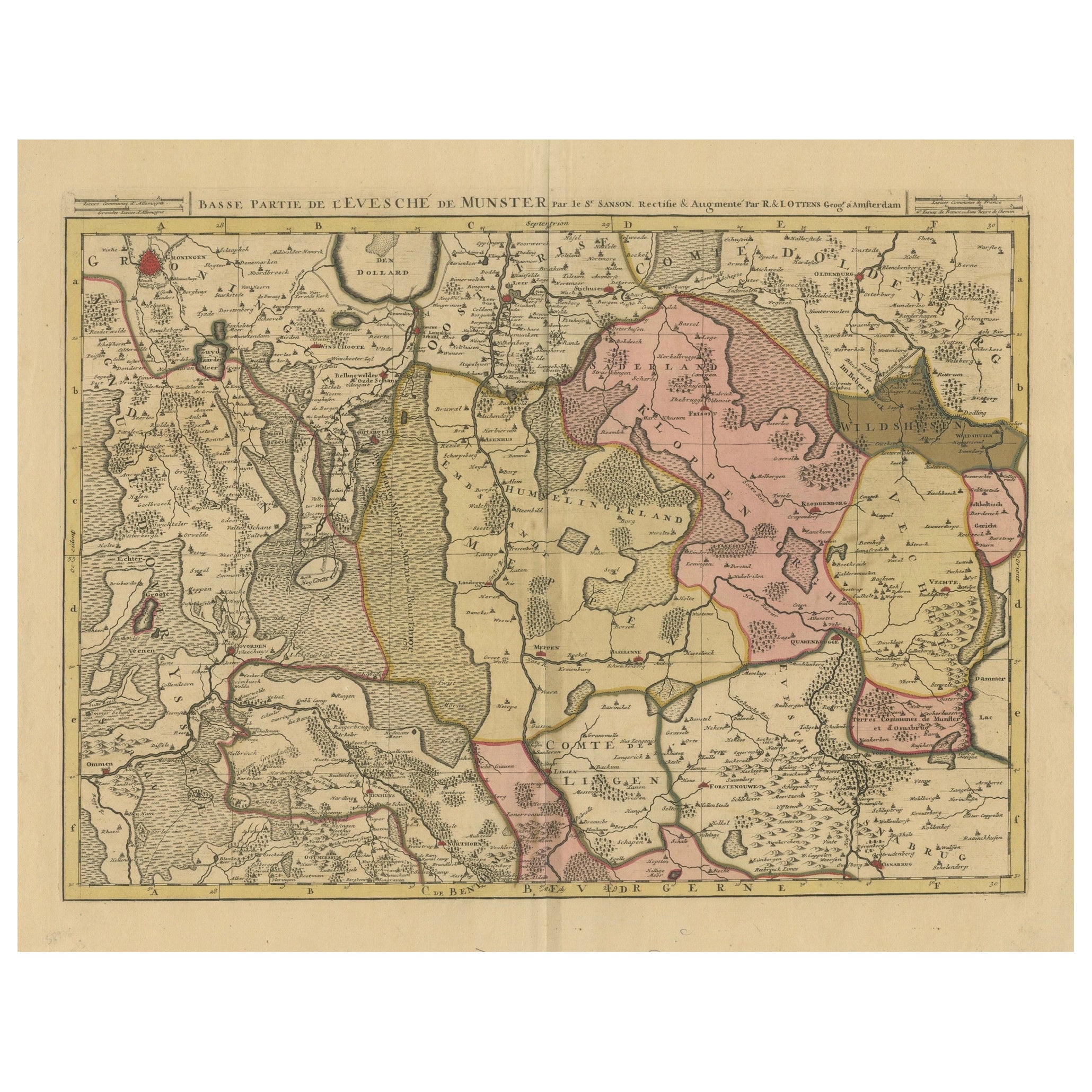
View AllOld Map of the Lower Bishopric of Münster (1726-1750) by Sanson
Ottens, c.1750
Located in Langweer, NL
Historical Map of the Lower Bishopric of Münster (1726-1750) by Sanson & Ottens – Hand-Colored Copperplate Engraving
The map titled "BASSE PARTIE DE L'EVESCHE DE MUNSTER" is a detai...
Category
Antique 1750s Maps
Materials
Paper
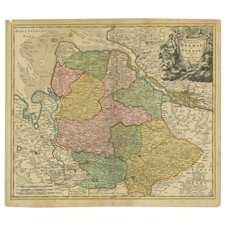
Antique Map of the Duchies of Bremen and Verden by Homann, c.1730
By Johann Baptist Homann
Located in Langweer, NL
Antique map titled 'Ducatus Bremae et Ferdae (..)'. Map of the Duchies of Bremen and Verden, Germany. Source unknown, to be determined.
Artists and Engravers: Johann Baptist Homan...
Category
Antique 18th Century Maps
Materials
Paper

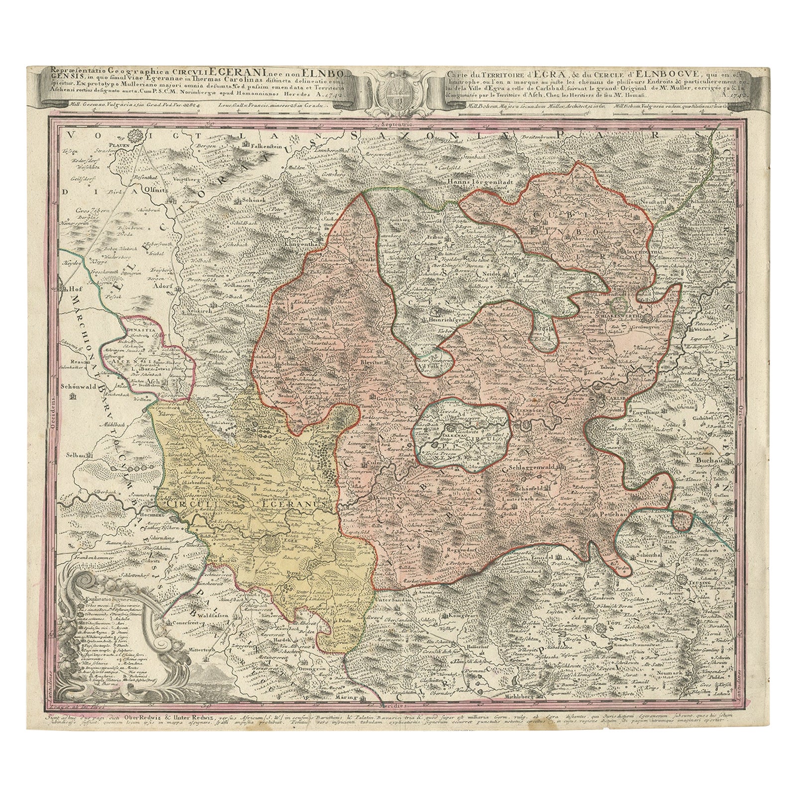
Antique Map of the Region of Elbogen
Eger, Czech Republic
Hungary, 1742
Located in Langweer, NL
Antique map titled 'Repraesentatio Geographica Circuli Egerani, nec non Elnbogensis : in quo simul viae Egeranae in Thermas Carolinas distincta delineatio conspicitur (..)'.
Orig...
Category
Antique 1740s Maps
Materials
Paper
$519 Sale Price
20% Off
Antique Map of Northern Germany by M. Seutter, circa 1730
By Matthew Seutter
Located in Langweer, NL
Antique map titled 'Saxoniae Inferioris Circulus'. Old map of the northern part of Germany by M. Seutter. Covering the area of Lower Saxony, Mecklenburg-Vorpommern and Schleswig-Hols...
Category
Antique Mid-18th Century Maps
Materials
Paper

Map of the Duchy of Pomerania – Antique Engraving by P. Schenk Jr., c. 1750
Located in Langweer, NL
Map of the Duchy of Pomerania – Antique Engraving by P. Schenk Jr., c. 1750
Antique map titled 'Ducatus Pomeraniae Tabula Generalis'. This historical map presents the Duchy of Pomer...
Category
Antique Mid-18th Century Dutch Maps
Materials
Paper

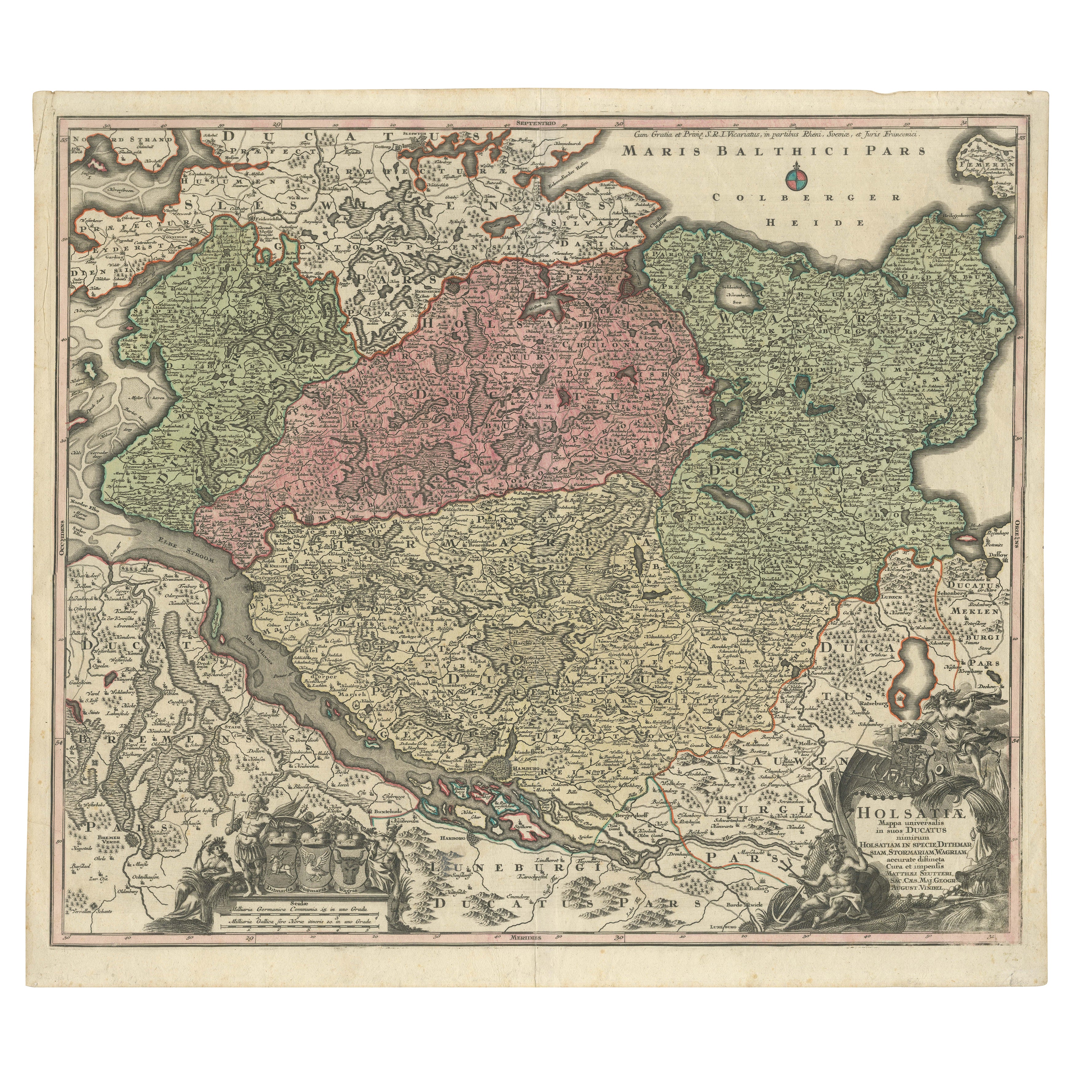
Historical Map of Holstein - Copperplate Engraving by Matthias Seutter, ca. 1730
Located in Langweer, NL
Historical Map of Holstein - Copperplate Engraving by Matthias Seutter, ca. 1730
This impressive historical map, titled Holsatiae. Mappa universalis in suos ducatus nimirum Holsat...
Category
Antique 1730s Maps
Materials
Paper
You May Also Like
18th Century Hand-Colored Homann Map of Germany, Including Frankfurt and Berlin
By Johann Baptist Homann
Located in Alamo, CA
An 18th century hand-colored map entitled "Tabula Marchionatus Brandenburgici et Ducatus Pomeraniae quae sunt Pars Septentrionalis Circuli Saxoniae Superioris" by Johann Baptist Homa...
Category
Antique Early 18th Century German Maps
Materials
Paper

$620 Sale Price
20% Off
Hand Colored 18th Century Homann Map of Austria Including Vienna and the Danube
By Johann Baptist Homann
Located in Alamo, CA
"Archiducatus Austriae inferioris" is a hand colored map of Austria created by Johann Baptist Homann (1663-1724) and published in Nuremberg, Germany in 1728 shortly after his death. ...
Category
Antique Early 18th Century German Maps
Materials
Paper

$540 Sale Price
20% Off
17th Century Hand-Colored Map of a Region in West Germany by Janssonius
By Johannes Janssonius
Located in Alamo, CA
This attractive highly detailed 17th century original hand-colored map is entitled "Archiepiscopatus Maghdeburgensis et Anhaltinus Ducatus cum terris adjacentibus". It was published ...
Category
Antique Mid-17th Century Dutch Maps
Materials
Paper

$1,020 Sale Price
20% Off
Prussia, Poland, N. Germany, Etc: A Hand-colored 17th Century Map by Janssonius
By Johannes Janssonius
Located in Alamo, CA
This is an attractive hand-colored copperplate engraved 17th century map of Prussia entitled "Prussia Accurate Descripta a Gasparo Henneberg Erlichensi", published in Amsterdam by Joannes Janssonius in 1664. This very detailed map from the golden age of Dutch cartography includes present-day Poland, Latvia, Lithuania, Estonia and portions of Germany. This highly detailed map is embellished by three ornate pink, red, mint green and gold...
Category
Antique Mid-17th Century Dutch Maps
Materials
Paper

$1,020 Sale Price
20% Off
1640 Willem Blaeu Map Entitled "Contado di molise et principato vltra, " Ric.a003
By Willem Blaeu
Located in Norton, MA
1640 Willem Blaeu map entitled
"Contado di molise et principato vltra,"
Colored
Ric. a003
Measures: 38 x 49.6 cm and wide margins
DBLAEU.
Cou...
Category
Antique 17th Century Dutch Maps
Materials
Paper

17th Century Hand Colored Map of the Liege Region in Belgium by Visscher
By Nicolaes Visscher II
Located in Alamo, CA
An original 17th century map entitled "Leodiensis Episcopatus in omnes Subjacentes Provincias distincté divisusVisscher, Leodiensis Episcopatus" by Nicolaes Visscher II, published in Amsterdam in 1688. The map is centered on Liege, Belgium, includes the area between Antwerp, Turnhout, Roermond, Cologne, Trier and Dinant.
This attractive map is presented in a cream-colored mat measuring 30" wide x 27.5" high. There is a central fold, as issued. There is minimal spotting in the upper margin and a tiny spot in the right lower margin, which are under the mat. The map is otherwise in excellent condition.
The Visscher family were one of the great cartographic families of the 17th century. Begun by Claes Jansz Visscher...
Category
Antique Late 17th Century Dutch Maps
Materials
Paper

$940 Sale Price
20% Off
More Ways To Browse
Historical Documents
Schleswig Holstein
Leather Pouf And Ottomans
Low Side Tables
Set Of Four Italian Dining Chairs
Silk Runner Carpet
3x5 Rugs
Italian Lacquer Dining Room Sets
Round Brass Table
Round Table Base
Belgian Antiques
Cream Soup
Early English Silver
James Bond
Paisley Rugs and Carpets
Antique Pagoda
Black And Chrome Lounge Chair
Ceramic 1960s Italy