Items Similar to Historical Map of Holstein - Copperplate Engraving by Matthias Seutter, ca. 1730


Want more images or videos?
Request additional images or videos from the seller
1 of 11
Historical Map of Holstein - Copperplate Engraving by Matthias Seutter, ca. 1730
$640.44
£481.35
€540
CA$887.34
A$964.50
CHF 516.31
MX$11,658.57
NOK 6,506.54
SEK 6,000.72
DKK 4,113.60
About the Item
Historical Map of Holstein - Copperplate Engraving by Matthias Seutter, ca. 1730
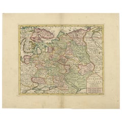
This impressive historical map, titled Holsatiae. Mappa universalis in suos ducatus nimirum Holsatiam in Specie, Dithmarsiam, Stormariem, Wagriam..., originates from the workshop of the famous Augsburg cartographer Matthias Seutter and was created around 1730. The map is a magnificent, partially colored copperplate engraving that depicts the former duchies of Holstein, Dithmarschen, Stormarn, and Wagrien, located in what is now northern Germany and southern Denmark.
The map impresses with its detailed and precise depiction of the region and is also a masterpiece of artistic craftsmanship. The old hand coloring, which highlights parts of the map in green, pink, and yellow, accentuates the political entities and territorial boundaries, creating a vivid overall impression. The borders are carefully drawn and emphasize the geographical diversity of the region.
In the lower right area of the map, there is a splendid title cartouche that not only conveys the name and geographic significance of the map but also features an allegorical representation of fishing. This symbolizes the traditional importance of fishing in the region. The coat of arms crowning the cartouche highlights the historical significance of the Duchy of Holstein.
Another remarkable detail is the mileage indicator in the lower left part of the map, adorned with the coats of arms of Dithmarschen, Stormarn, and Wagrien. These artistic additions make the map not only a valuable historical document but also a testament to the baroque art of cartography.
Matthias Seutter was one of the most prominent cartographers of his time and served as the official geographer to Emperor Charles VI in Augsburg. His maps are distinguished by exceptional precision and artistic design, and his works were highly valued both by contemporaries and collectors.
The copperplate engraving technique, mastered by Seutter, required great craftsmanship. The map image was first engraved in reverse onto a copper plate, then inked and pressed onto paper. The elaborate hand coloring followed later, giving the map its distinctive visual depth.
Condition: Good condition with only slight signs of aging. Some minor folds and a slightly aged tone are present but do not detract from the aesthetic appeal. The colors are well-preserved and display beautiful vibrancy.
Framing Tip: A dark wood frame with a cream-colored mat under non-reflective, UV-protected glass offers optimal protection and an appealing presentation. Archival-quality materials ensure the preservation of this rare map for future generations.
- Dimensions:Height: 21.26 in (54 cm)Width: 24.02 in (61 cm)Depth: 0.01 in (0.2 mm)
- Materials and Techniques:Paper,Engraved
- Period:1730-1739
- Date of Manufacture:circa 1730
- Condition:Good condition with signs of aging. Some minor folds and a slightly aged tone are present but do not detract from the aesthetic appeal. The colors are well-preserved and display beautiful vibrancy. Check the scans carefully or ask for more photos.
- Seller Location:Langweer, NL
- Reference Number:Seller: BG-13842-271stDibs: LU3054344168972
About the Seller
5.0
Recognized Seller
These prestigious sellers are industry leaders and represent the highest echelon for item quality and design.
Platinum Seller
Premium sellers with a 4.7+ rating and 24-hour response times
Established in 2009
1stDibs seller since 2017
2,781 sales on 1stDibs
Typical response time: <1 hour
- ShippingRetrieving quote...Shipping from: Langweer, Netherlands
- Return Policy
More From This Seller
View All18th-Century Map of Holstein and Surrounding Duchies by Homann Heirs
Located in Langweer, NL
18th-Century Map of Holstein and Surrounding Duchies by Homann Heirs
Description: This finely detailed 18th-century map by the Homann Heirs (Homannische Erben) illustrates the Duc...
Category
Antique 1750s Maps
Materials
Paper

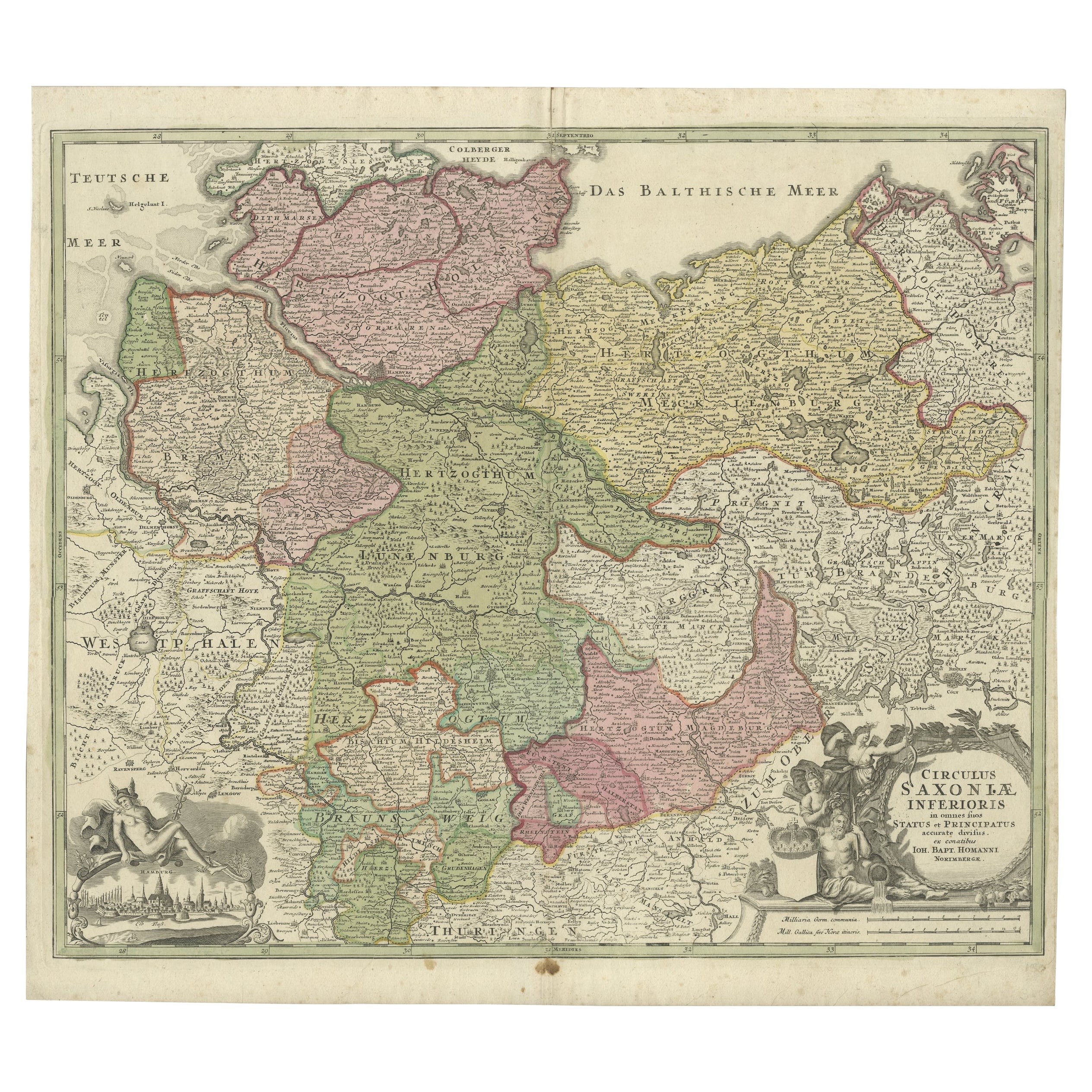
Antique Engraved Map of Saxonia in Northern Germany, ca.1721-1750
Located in Langweer, NL
Duitsland, Sassonia; Johannes Baptist Homann - Circulus Saxoniae Inferioris in omnes suos Status et Principatus accurate divisus ex conatibus -
A large map of Lower Saxony, exten...
Category
Antique Mid-18th Century Maps
Materials
Paper
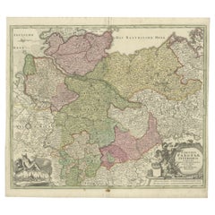
Antique Map of Northern Germany by M. Seutter, circa 1730
By Matthew Seutter
Located in Langweer, NL
Antique map titled 'Saxoniae Inferioris Circulus'. Old map of the northern part of Germany by M. Seutter. Covering the area of Lower Saxony, Mecklenburg-Vorpommern and Schleswig-Hols...
Category
Antique Mid-18th Century Maps
Materials
Paper

Decorative Antique Map of Austria – Frederick de Wit, Amsterdam c.1690
Located in Langweer, NL
Antique Map of Austria – “Circuli Austriaci pars Septentrionalis” by F. de Wit, c.1670
This finely engraved map, titled “Circuli Austriaci pars Septent...
Category
Antique Late 17th Century Dutch Maps
Materials
Paper

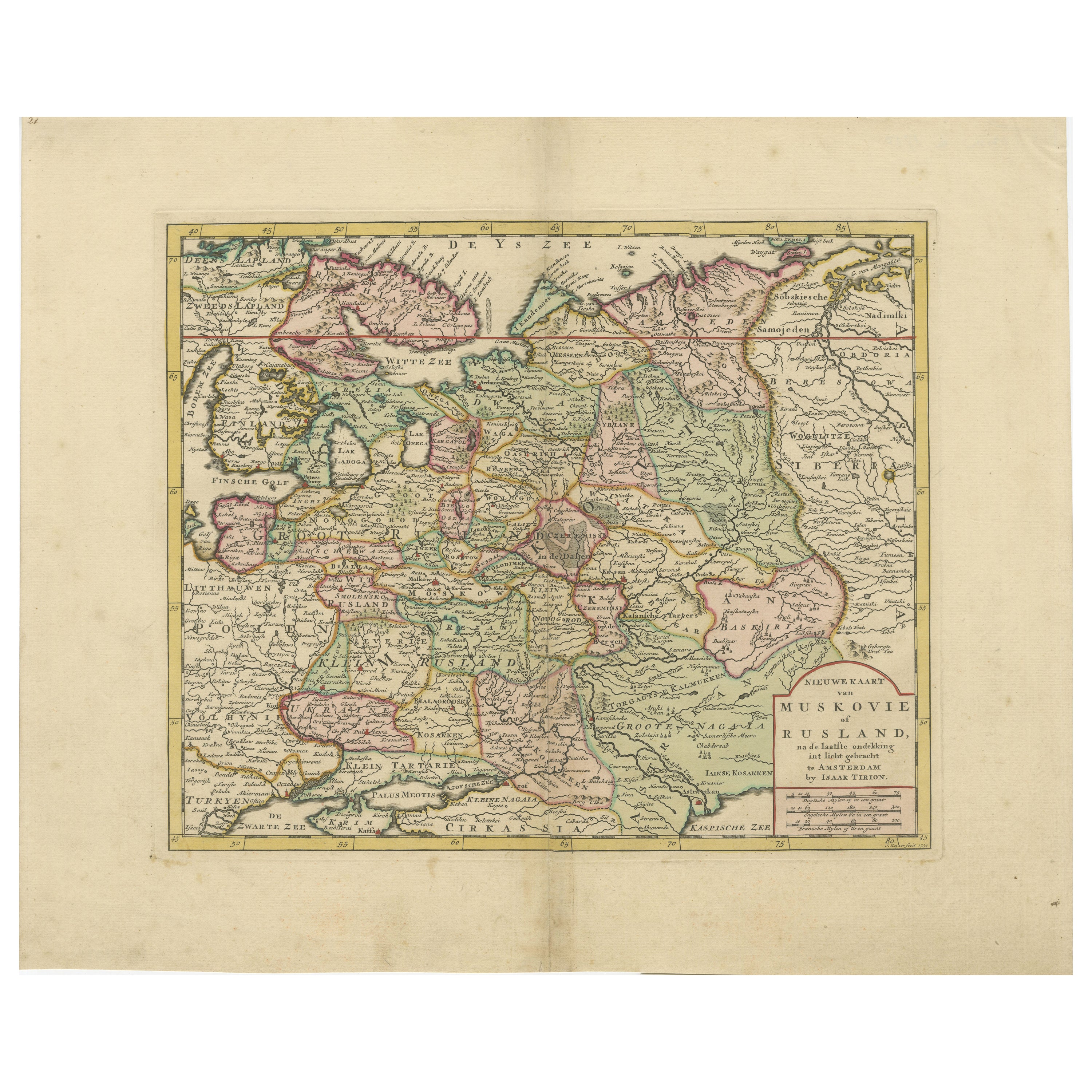
Original Antique Map of Muscovy or Russia by Isaak Tirion, Amsterdam circa 1740
Located in Langweer, NL
Map of Muscovy or Russia by Isaak Tirion, Amsterdam circa 1740
Description:
This beautifully engraved and delicately hand-colored map titled "Nieuwe Kaart van Muskovië of Rusland" w...
Category
Antique Mid-18th Century Dutch Maps
Materials
Paper
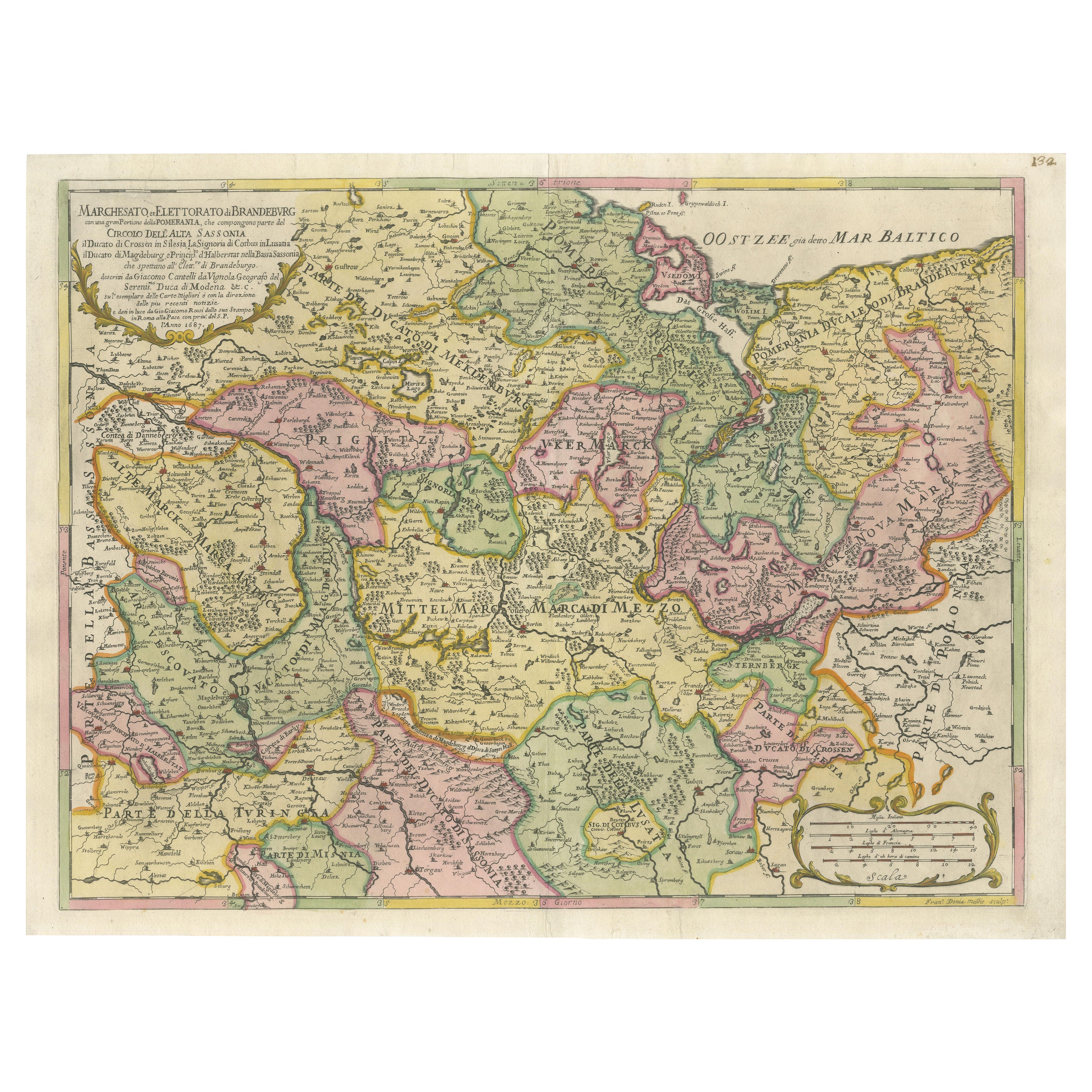
Old Map of the Margraviate of Brandenburg by Giacomo Cantelli da Vignola, 1687
Located in Langweer, NL
Historical Map of the Margraviate of Brandenburg by Giacomo Cantelli da Vignola - 1687
This magnificent map, titled Marchesato, et Elettorato di Brandeburgo con una gran Porzione ...
Category
Antique 1680s Maps
Materials
Paper

You May Also Like
West Germany: Original Hand Colored 17th Century Map by Johannes Janssonius
By Johannes Janssonius
Located in Alamo, CA
An original hand colored copperplate engraved map entitled in Latin "Archiepiscopatus Maghdeburgensis et Anhaltinus Ducatus cum terris adjacentibus", published in Amsterdam in 1640 i...
Category
Mid-17th Century Old Masters More Prints
Materials
Engraving

1790 Thomas Stackhouse Map, Entitled "Russia in Europe, " , Ric.a004
Located in Norton, MA
1790 Thomas Stackhouse map, entitled
"Russia in Europe"
Ric.a004
Stackhouse, Thomas
Russia in Europe [map]
London: T. Stackhouse, 1783. Map. Matted hand-colored copper engraving. Image size: 14.5 x 15.25 inches. Mat size: 22.75 x 23.75 inches. A beautiful example of this map of Eastern Europe...
Category
Antique 17th Century Unknown Maps
Materials
Paper

17th Century Nicolas Visscher Map of Southeastern Europe
Located in Hamilton, Ontario
A beautiful, highly detailed map of southeastern Europe by Nicolas Visscher. Includes regions of Northern Italy (showing the cities Bologna, Padua, and Venice), Bohemia, Austria (sho...
Category
Antique 17th Century Dutch Maps
Materials
Paper

$1,350 Sale Price
38% Off
1657 Janssonius Map of Vermandois and Cappelle, Ric. A-004
Located in Norton, MA
1657 Janssonius map of
Vermandois and Cappelle
Ric.a004
Description: Antique map of France titled 'Descriptio Veromanduorum - Gouvernement de la Cappelle'. Two detailed maps o...
Category
Antique 17th Century Unknown Maps
Materials
Paper

Engraving Depicting 16th Century Map of Terra Sancta
Located in Buchanan, MI
Abraham Ortelius (Flemish, 1527-1598) Terra Sancta.
Engraving depicting 16th century map of Terra Sancta. Site 15" x 19.5.
Category
Antique 18th Century and Earlier Maps
Materials
Paper

Map of the War -Vesfaglia and Lower Saxony - Etching - 19th Century
Located in Roma, IT
Map of the War -Vestaglia and Lower Saxony is an etching realized during the 19th century.
Good condition.
Category
Early 19th Century Modern Figurative Prints
Materials
Etching

More Ways To Browse
Historical Documents
Leather Pouf And Ottomans
Low Side Tables
Set Of Four Italian Dining Chairs
Silk Runner Carpet
3x5 Rugs
Italian Lacquer Dining Room Sets
Round Brass Table
Round Table Base
Belgian Antiques
Cream Soup
Early English Silver
James Bond
Paisley Rugs and Carpets
Antique Pagoda
Black And Chrome Lounge Chair
Ceramic 1960s Italy
Vintage 1930 Dining Room Set