Items Similar to Historical Map of the Netherlands in the 16th and 17th Centuries, Leiden 1876
Want more images or videos?
Request additional images or videos from the seller
1 of 9
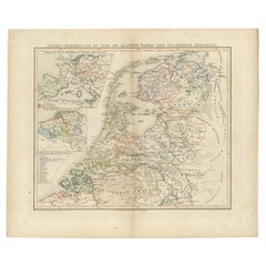
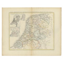
Historical Map of the Netherlands in the 16th and 17th Centuries, Leiden 1876
$383.30
£286.71
€320
CA$528.17
A$580.58
CHF 304.80
MX$6,903.56
NOK 3,914.37
SEK 3,565.57
DKK 2,438.73
About the Item
Historical Map of the Netherlands in the 16th and 17th Centuries, Leiden 1876
This 19th-century Dutch historical map, titled “De Nederlanden in het begin der 16de eeuw en in het begin der 17de eeuw,” was published in 1876 in the Nieuwe Hand-Atlas der Aarde in haren Tegenwoordigen Toestand by M. Frijlink, revised by A. van Otterloo, and issued by D. Noothoven van Goor in Leiden. The map presents the Low Countries (modern Netherlands and Belgium) at two significant moments in their early modern history — the beginning of the 16th century and the early 17th century — showing the profound political and territorial transformations that shaped the Dutch Republic.
The plate is divided into two sections. The left map depicts the Netherlands under Habsburg rule around 1500, highlighting the territorial divisions of the Burgundian inheritance. The right-hand map shows the situation after the Dutch Revolt and the formation of the independent Republic of the Seven United Provinces, roughly a century later. The evolving borders, fortified towns, and shifting spheres of control illustrate the rise of the Dutch nation-state. Insets at the top further clarify regional changes in the northern provinces and Friesland.
This dual historical map served both as an educational and a political reference in Frijlink’s Nieuwe Hand-Atlas, offering insight into the Netherlands’ emergence from medieval feudal territories into a modern maritime power. It exemplifies the precision and historical awareness characteristic of Dutch academic cartography in the 19th century.
Condition report:
Good condition overall, with moderate toning and faint foxing along the upper edge. Original center fold as issued. The printed image remains sharp and even, with no tears or losses. Paper slightly browned at the margins consistent with age.
Framing tips:
This map pairs beautifully with other historical plates in the series. It looks best with a light cream mat and a slim walnut or black frame to emphasize the subtle engraving and historic subject. Ideal for libraries or spaces devoted to history and cartography.
Technique: Lithograph
Maker: M. Frijlink
A. van Otterloo, published by D. Noothoven van Goor, Leiden, 1876
- Dimensions:Height: 17.33 in (44 cm)Width: 21.66 in (55 cm)Depth: 0.01 in (0.2 mm)
- Materials and Techniques:
- Place of Origin:
- Period:
- Date of Manufacture:1876
- Condition:Good condition overall, with moderate toning and faint foxing along the upper edge. Original center fold as issued. The printed image remains sharp and even, with no tears or losses. Paper slightly browned at the margins consistent with age.
- Seller Location:Langweer, NL
- Reference Number:Seller: BG-12788-131stDibs: LU3054347455002
About the Seller
5.0
Recognized Seller
These prestigious sellers are industry leaders and represent the highest echelon for item quality and design.
Platinum Seller
Premium sellers with a 4.7+ rating and 24-hour response times
Established in 2009
1stDibs seller since 2017
2,800 sales on 1stDibs
Typical response time: <1 hour
- ShippingRetrieving quote...Shipping from: Langweer, Netherlands
- Return Policy
More From This Seller
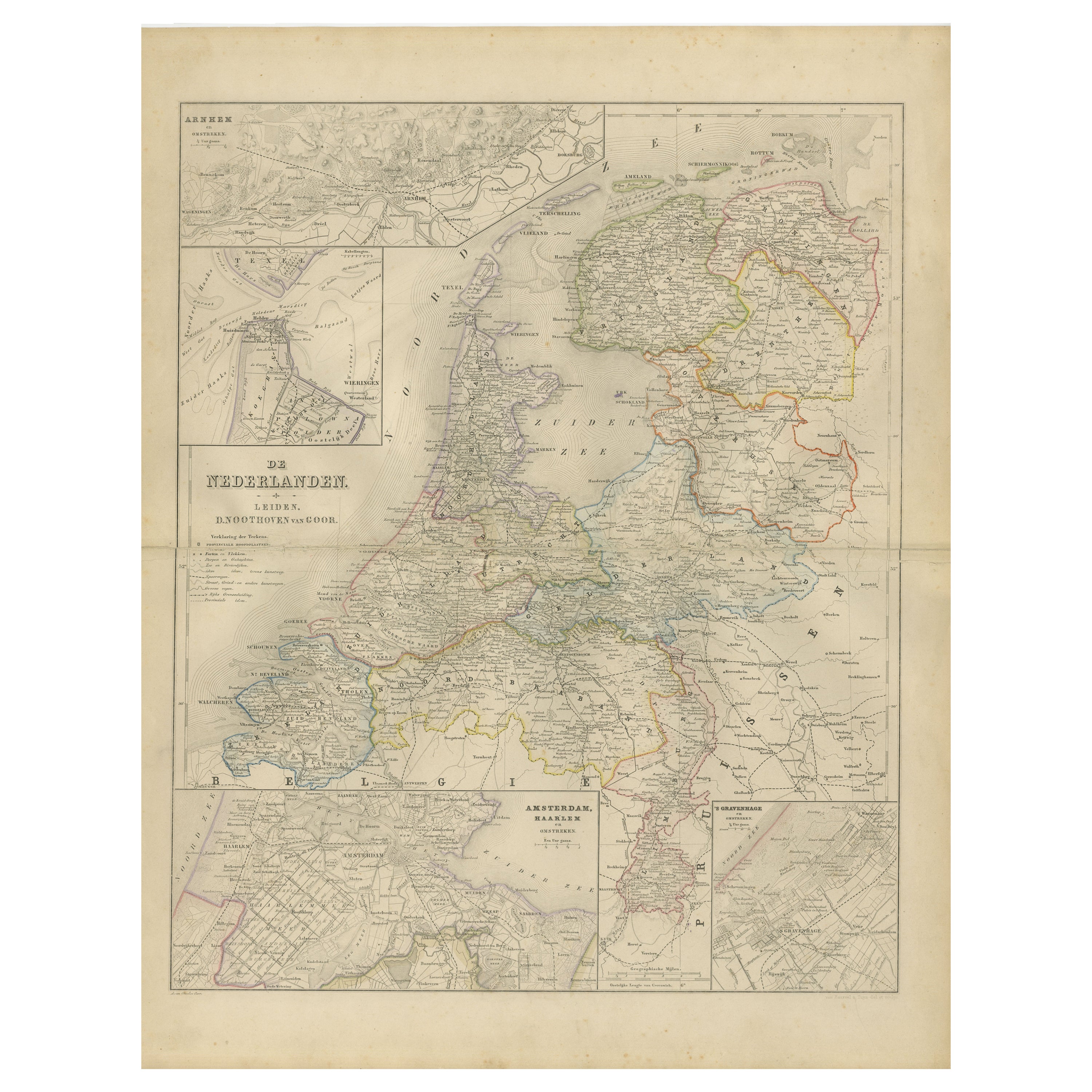
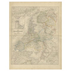
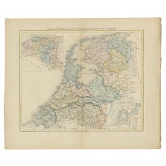
View AllMap of the Netherlands with Insets of Amsterdam and Arnhem, Leiden 1876
Located in Langweer, NL
Map of the Netherlands with Insets of Amsterdam and Arnhem, Leiden 1876
This detailed 19th-century Dutch map, titled “De Nederlanden,” was published in 1876 in the Nieuwe Hand-Atlas...
Category
Antique 1870s Dutch Maps
Materials
Paper
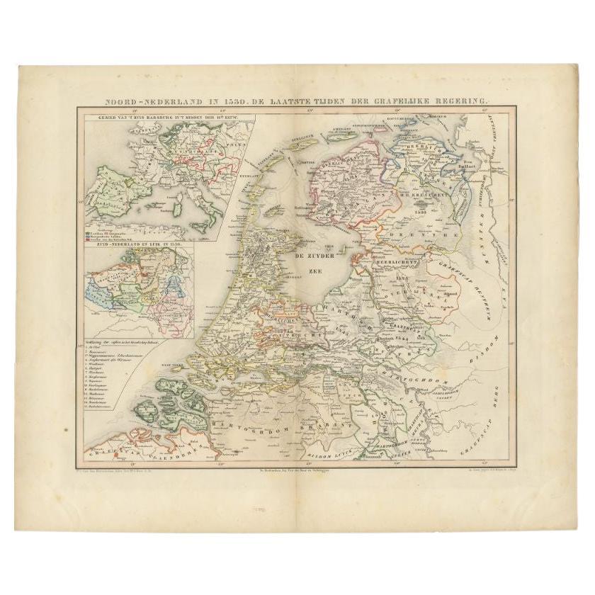
Antique Map of the Netherlands in 1530 by Mees, 1852
Located in Langweer, NL
Antique map titled 'Noord-Nederland in 1530. De laatste tijden der Grafelijke Regering'. Map of the Netherlands in 1530. This map originates from 'Historische Atlas van Noord-Nederla...
Category
Antique 19th Century Maps
Materials
Paper
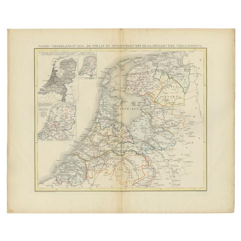
Antique Map of the Netherlands in 1859 by Mees, 1861
Located in Langweer, NL
Antique map titled 'Noord-Nederland in 1859. De Straat- en Spoorwegen met de jaartallen der vervaardiging'. Map of the Netherlands in 1859. This map originates from 'Historische Atla...
Category
Antique 19th Century Maps
Materials
Paper
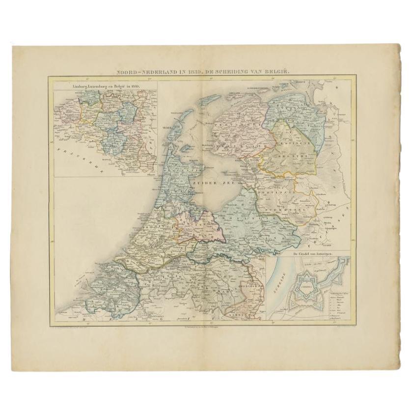
Antique Map of the Netherlands in 1839 by Mees, 1860
Located in Langweer, NL
Antique map titled 'Noord-Nederland in 1839. De scheiding van België'. Map of the Netherlands in 1839. This map originates from 'Historische Atlas van Noord-Nederland'.
Artists a...
Category
Antique 19th Century Maps
Materials
Paper
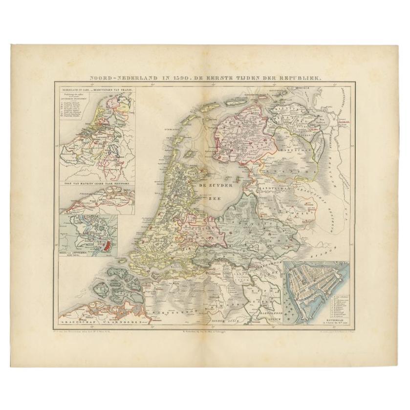
Antique Map of the Netherlands in 1590 by Mees, 1854
Located in Langweer, NL
Antique map titled 'Noord-Nederland in 1590. De eerste tijden der Republiek'. Map of the Netherlands in 1590. This map originates from 'Historische Atlas van Noord-Nederland'.
Ar...
Category
Antique 19th Century Maps
Materials
Paper
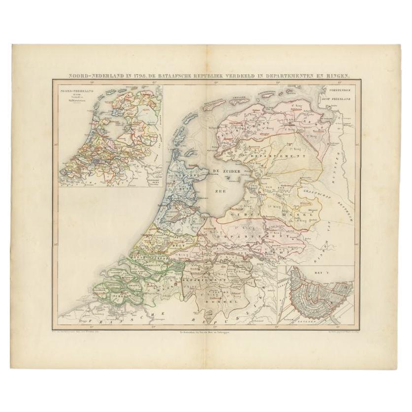
Antique Map of the Netherlands in 1798 by Mees, 1851
Located in Langweer, NL
Antique map titled 'Noord-Nederland in 1798. De Bataafsche Republiek verdeeld in departementen en ringen'. Map of the Netherlands in 1798. This map originates from 'Historische Atlas...
Category
Antique 19th Century Maps
Materials
Paper
You May Also Like
The Netherlands (Holland), Belgium and Luxemburg. Century Atlas antique map
Located in Melbourne, Victoria
'The Century Atlas. The Netherlands (Holland), Belgium and Luxemburg.'
Original antique map, 1903.
Inset maps of 'Amsterdam' and 'Brussels'.
Central fold as issued. Map name and num...
Category
Early 20th Century Victorian More Prints
Materials
Lithograph

1752 Vaugoundy Map of Flanders : Belgium, France, and the Netherlands, Ric.a002
Located in Norton, MA
Large Vaugoundy Map of Flanders:
Belgium, France, and the Netherlands
Colored -1752
Ric.a002
Description: This is a 1752 Didier Robert de Vaugondy map of Flanders. The map de...
Category
Antique 17th Century Unknown Maps
Materials
Paper

1643 Willem&Joan Blaeu Map NW Flanders "Flandriae Teutonicae Pars Prientalior
Located in Norton, MA
1643 Willem and Joan Blaeu map of northwest Flanders, entitled
"Flandriae Teutonicae Pars Prientalior,"
Ric0012
" Authentic" - Map of the northwest Fl...
Category
Antique 17th Century Dutch Maps
Materials
Paper

France, Northern Part. Century Atlas antique map
Located in Melbourne, Victoria
'The Century Atlas. France, Northern Part.'
Original antique map, 1903.
Inset maps of 'France in Provinces' and 'Paris and Vicinity'.
Central fold as issued. Map name and number pr...
Category
Early 20th Century Victorian More Prints
Materials
Lithograph

1839 Map of Karte Des "Russischen Reiches in Europa Und Asien" Ric.R0013
Located in Norton, MA
1839 map of Karte Des
"Russischen Reiches in Europa and Asien"
Ric.r013
Map of the European and Asian parts of Russian Empire. Karte der Russischen Reiches in Europa und Asien...
Category
Antique 19th Century Unknown Maps
Materials
Paper

1590 Ortelius Map of Calais and Vermandois, France and Vicinity Ric.a014
Located in Norton, MA
1590 Ortelius map of
Calais and Vermandois, France and Vicinity
Ric.a014
Two rare regional Abraham Ortelius maps on a single folio sheet. Left map, entitled Caletensium, depic...
Category
Antique 16th Century Dutch Maps
Materials
Paper
