Items Similar to Holy Land Map, Terra Promissa or Judaea – Nicolas Sanson, c.1700


Want more images or videos?
Request additional images or videos from the seller
1 of 9
Holy Land Map, Terra Promissa or Judaea – Nicolas Sanson, c.1700
$528.84
£391.73
€440
CA$723.43
A$788.50
CHF 416.87
MX$9,492.06
NOK 5,291.16
SEK 4,850.92
DKK 3,352.56
About the Item
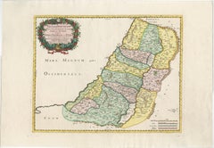
Holy Land Map, Terra Promissa or Judaea – Nicolas Sanson, c.1700
This antique map depicts the Holy Land, or Terra Promissa (Promised Land), as described in the Old and New Testaments, presenting Judaea divided according to biblical tradition. Titled Geographiae Sacræ ex Veteri et Novo Testamento desumptæ Tabula, in qua Terra Promissa sive Judæa, the map illustrates the land historically associated with the Twelve Tribes of Israel, with boundaries, cities, rivers, deserts, and regions carefully laid out.
The map was created by Nicolas Sanson (1600–1667), regarded as the founder of French scientific cartography. Although Sanson died in 1667, his maps continued to be published and reissued by his heirs and successors into the late 17th and early 18th centuries, making circa 1700 a plausible date for this impression. Sanson’s biblical maps were widely used for theological study, historical reference, and education, reflecting contemporary European scholarship rather than modern geographical accuracy.
The map extends from the Mediterranean coast to Arabia and Idumaea, and from Phoenicia in the north to the deserts south of Judaea. The River Jordan, the Dead Sea, Galilee, Samaria, and Judaea are prominently shown, with dense place-name detail throughout. A decorative engraved title cartouche appears in the upper left, framed by baroque foliage, reinforcing the scholarly yet ornamental character of the work. The engraving is uncoloured, emphasizing line work and textual density typical of Sanson’s cartographic style.
This map is well suited to collectors of early biblical cartography, Holy Land maps, and French 17th-century engraving. Its restrained appearance and strong historical associations also make it attractive as a decorative interior piece for libraries, studies, or gallery walls.
Condition:
Fair to good condition. Uncoloured engraved map with original old folds. Light overall toning consistent with age. Minor handling wear and light creasing visible. No major losses to the engraved surface.
Framing tips:
This map benefits from a light parchment or warm off-white mat to preserve its scholarly character. A simple dark wood or black frame works well to highlight the fine engraving and dense detail. UV-protective glazing is recommended.
Technique: Copper engraving
Maker: Nicolas Sanson, France, circa 1700
Keywords: Jerusalem, Holy Land, Holy City, Renaissance Jerusalem view, antique Jerusalem print, biblical Jerusalem, Holy Sepulchre, Temple of Solomon, Mount Zion, Gethsemane, Valley of Jehoshaphat, Jericho, biblical geography, early Holy Land map, 16th century woodcut, Renaissance woodcut, Sebastian Münster circle, antique religious print, Christian cartography, biblical city view, antique Israel print, Palestine, sacred geography, early modern cosmography
- Dimensions:Height: 17.13 in (43.5 cm)Width: 21.34 in (54.2 cm)Depth: 0.01 in (0.2 mm)
- Materials and Techniques:Paper,Engraved
- Place of Origin:
- Period:
- Date of Manufacture:circa 1700
- Condition:Fair to good condition. Uncoloured engraved map with original old folds. Light overall toning consistent with age. Minor handling wear and light creasing visible. No major losses to the engraved surface.
- Seller Location:Langweer, NL
- Reference Number:Seller: BG-14153-21stDibs: LU3054348101732
About the Seller
5.0
Recognized Seller
These prestigious sellers are industry leaders and represent the highest echelon for item quality and design.
Platinum Seller
Premium sellers with a 4.7+ rating and 24-hour response times
Established in 2009
1stDibs seller since 2017
2,813 sales on 1stDibs
Typical response time: 1 hour
- ShippingRetrieving quote...Shipping from: Langweer, Netherlands
- Return Policy
More From This Seller
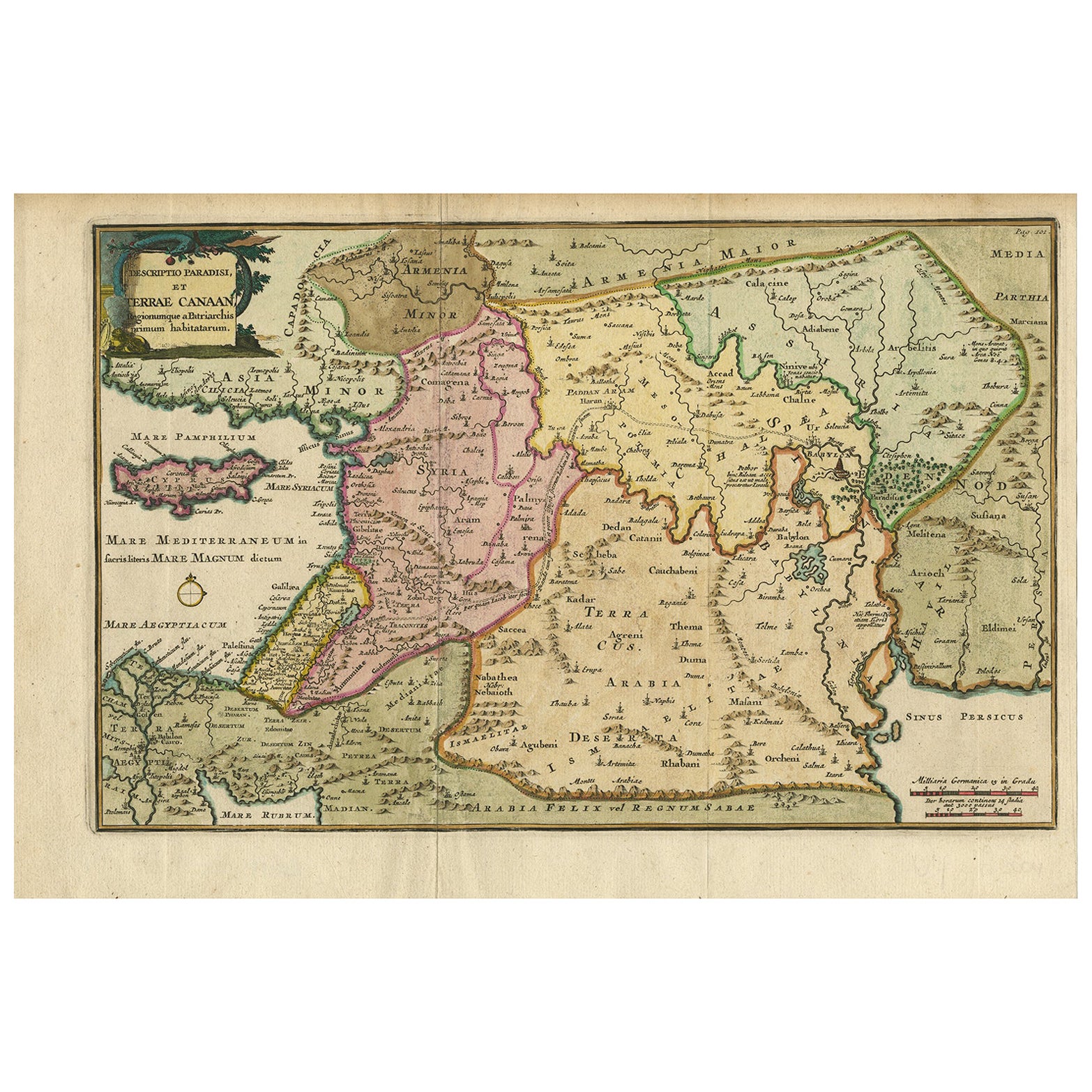
View AllAntique Map of the Holy Land and Paradise – Terrae Canaan Map, c.1720
Located in Langweer, NL
Antique Map of the Holy Land and Paradise by François Halma, c.1720
Beautiful early 18th-century hand-colored map of the Middle East extending from the Mediterranean Sea to the Pers...
Category
Antique Early 18th Century Dutch Maps
Materials
Paper

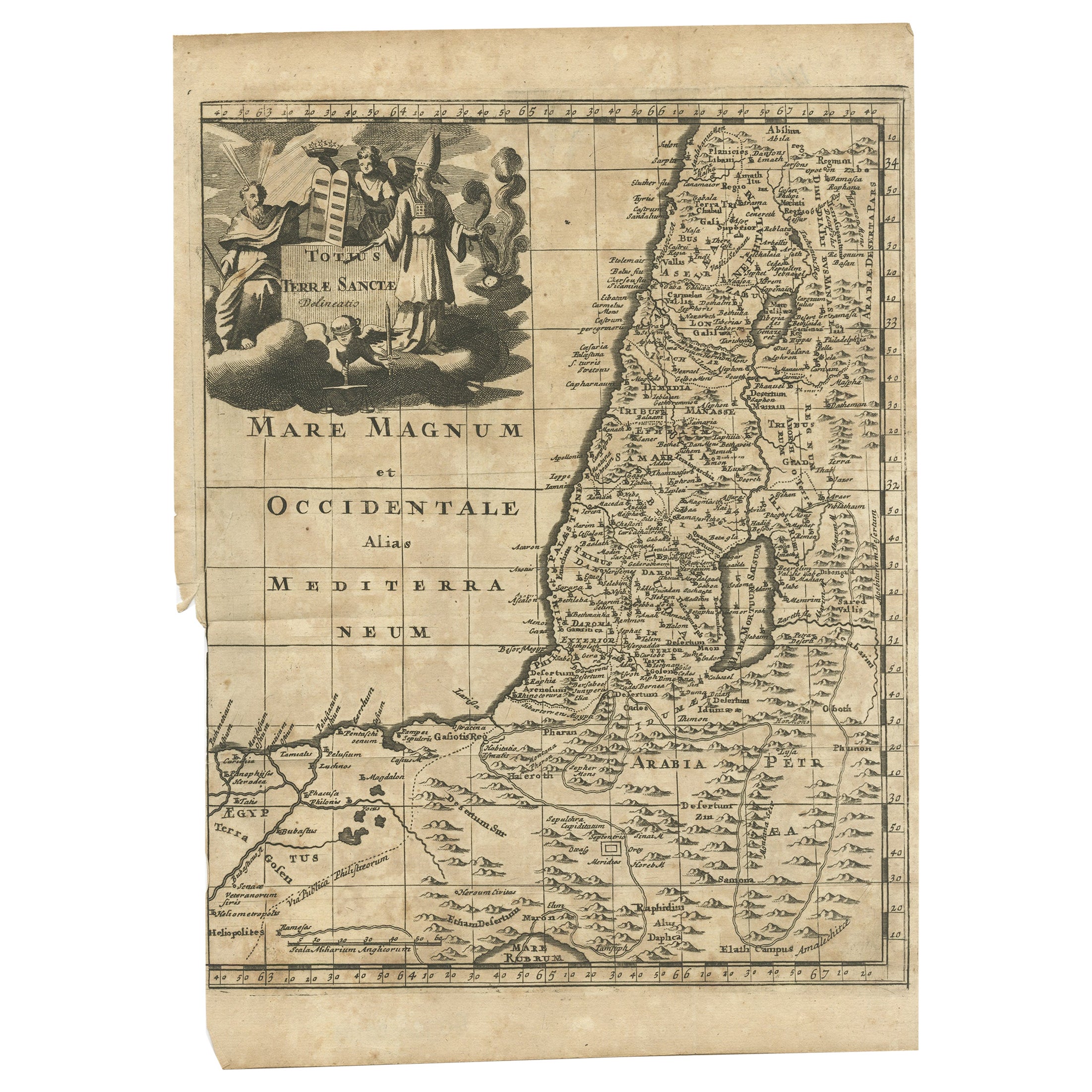
Antique Map of the Holy Land, c.1710
Located in Langweer, NL
Antique map titled 'Totius Terrae Sanctae Delineatio'. Map of the Holy Land extending to Egypt and showing the route of the Children of Israel in their e...
Category
Antique 18th Century Maps
Materials
Paper
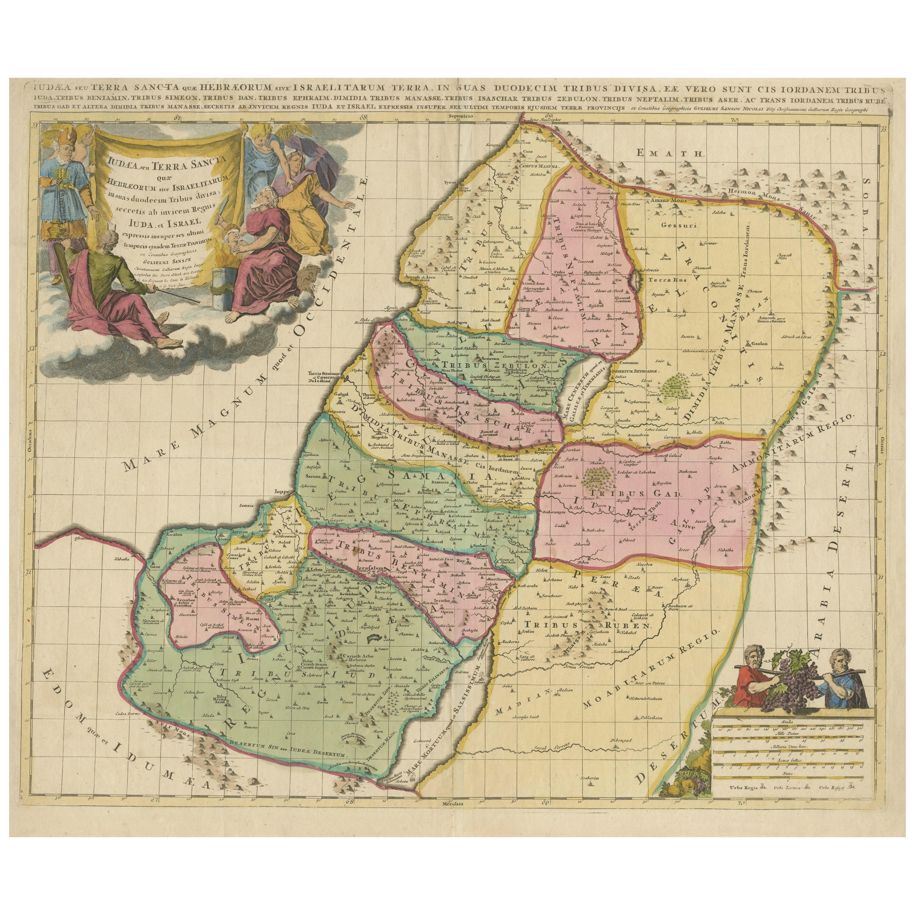
Antique Holy Land Map, Twelve Tribes of Israel – Covens
Mortier, c.1700
Located in Langweer, NL
Antique Holy Land Map, Twelve Tribes of Israel – Covens
Mortier, c.1700
Description:
This finely engraved early 18th-century map depicts the Holy Land divided according to the...
Category
Antique Early 18th Century French Maps
Materials
Paper

Holy Land Map of the Twelve Tribes of Israel – Sanson, Hand Colored, 1696
Located in Langweer, NL
Holy Land Map of the Twelve Tribes of Israel – Sanson, Hand Colored, 1696
Description:
This impressive and richly hand-colored map of the Holy Land depicts the biblical territories ...
Category
Antique Late 17th Century French Maps
Materials
Paper
Holy Land Map of the Twelve Tribes of Israel, After Sanson, Paris c.1798
Located in Langweer, NL
Holy Land, Twelve Tribes of Israel – After Nicolas Sanson, De Vaugondy / Delamarche, c.1798
Description:
Holy Land. De Vaugondy (G. R.), Carte de la Terre des Hébreux ou Israélites,...
Category
Antique Late 18th Century French Maps
Materials
Paper

Judaea or Terra Sancta, Twelve Tribes of Israel – Sanson Map, c.1680
Located in Langweer, NL
Judaea or Terra Sancta, Twelve Tribes of Israel – Sanson Map, c.1680
This antique map depicts Judaea or the Holy Land divided among the Twelve Tribes of Israel, based on biblical ge...
Category
Antique Late 17th Century Dutch Maps
Materials
Paper
You May Also Like
Map of the Kingdom of Sardinia and Part of the Kingdom of Genoa, Rome
By Giovanni Maria Cassini
Located in Hamilton, Ontario
18th century map by Italian engraver Giovanni Maria Cassini (Italy 1745-1824). Map of Part of the Kingdom of Sardinia and Part of the Kingdom of Genoa: Rome. This is a hand colored a...
Category
Antique 18th Century Italian Maps
Materials
Paper

$795 Sale Price
36% Off
17th Century Dutch Map of the Holy Land at the Time of Jesus by Visscher
By Nicolaus Visscher
Located in Alamo, CA
This detailed Dutch map entitled "Het Beloofe de Landt Canaan door wandelt van onsen Salichmaecker Iesu Christo, nessens syne Apostelen" by Nicolaes Visscher (1610-1679), published i...
Category
1660s Prints and Multiples
Materials
Engraving

$1,020 Sale Price
20% Off
Map Holy Land La Terre Sainte Engraved van Loon Published N de Fer 1703 French
Located in BUNGAY, SUFFOLK
La Terre Sainte, The Holy Land, Tiree Des Memoires De M.De.La Rue. Par N. de Fer. Geographe de Sa Majeste Catoliq et de Monseigneur le Dauphin. Avec Privil du Roi 1703
Detailed map of the Holy Land from Nicholas de Fer's L'Atlas Curieux ou le Monde. East is oriented at the top.
MAKER Nicolas de Fer 1646-1720
The French cartographer and engraver, Nicolas de Fer, was a master at creating maps that were works of art. The maps that he published were printed during the Baroque period when the decorative arts were characterized by ornate detail. De Fer’s detailed maps and atlases were valued more for their decorative content than their geographical accuracy.
Nicolas de Fer was born in 1646. His father, Antoine de Fer, owned a mapmaking firm. At the age of twelve, Nicolas was apprenticed to a Parisian engraver named Louis Spirinx. The family business was starting to decline when his father died in 1673. Nicolas de Fer’s mother, Genevieve, took over the business after the death of her husband. In 1687 the business was passed on to Nicolas and the profits increased after he took over the firm. Nicolas de Fer was a prolific cartographer who produced atlases and hundreds of single maps. He eventually became the official geographer to King Louis XIV of France and King Philip V...
Category
Antique Early 1700s French Louis XIV Maps
Materials
Paper

Li Governi di Borgogna - Ancient Map - 1777
Located in Roma, IT
Li Governi di Borgogna is an original black and white etching on paper, printed by Antonio Zatta in Venice, 1777.
Original Title: Li Governi di Borgogna della Franca Contea e del Ly...
Category
1770s Modern Landscape Prints
Materials
Etching

Southern Greece: A Large 17th Century Hand-colored Map By Sanson and Jaillot
By Nicholas Sanson d
Abbeville
Located in Alamo, CA
This large original hand-colored copperplate engraved map of southern Greece and the Pelopponese Peninsula entitled "La Moree Et Les Isles De Zante, Cefalonie, Ste. Marie, Cerigo & C...
Category
1690s Landscape Prints
Materials
Engraving

Antique Map - Gallia - Etching by Johannes Janssonius - 1650s
By Johannes Janssonius
Located in Roma, IT
Antique Map - Gallia is an antique map realized in 1650 by Johannes Janssonius (1588-1664).
The Map is Hand-colored etching, with coeval watercoloring.
Good conditions with slight ...
Category
1650s Modern Figurative Prints
Materials
Etching
