Items Similar to Irlandia – Antique Miniature Map of Ireland, Latin Cartography by Du Val c.1679


Want more images or videos?
Request additional images or videos from the seller
1 of 10
Irlandia – Antique Miniature Map of Ireland, Latin Cartography by Du Val c.1679
$300.31
£222.28
€250
CA$411
A$447.54
CHF 236.77
MX$5,397.16
NOK 3,012.55
SEK 2,754.11
DKK 1,904.45
About the Item
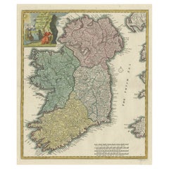
Title: IRLANDIA – Antique Map of Ireland, Latin Cartography by Du Val c.1650
Description:
This original antique map depicts the island of Ireland under the Latin title “Irlandia” and presents the country divided into its historic provinces and regions. The map is engraved in a clear, compact format and shows Ireland in full, bordered by latitude markings and surrounded by the Atlantic Ocean, here labeled “Oceanus.” The coastline is boldly delineated, with prominent bays, headlands, and inlets clearly articulated, reflecting the cartographic priorities of the mid-17th century.
The interior is densely labeled with towns, rivers, and regional names. Historic provinces such as Ultonia (Ulster), Connacia (Connacht), Lagenia (Leinster), and Momonia (Munster) are clearly identified. Numerous towns and settlements appear, including Dublin, Cork, Limerick, Waterford, Kilkenny, Galway, Athlone, and Armagh, among many others. Rivers and lakes are engraved schematically, providing geographic orientation rather than measured precision, consistent with period mapping practices.
The map is engraved in Latin and features a restrained title cartouche at the lower right reading “Irlandia,” followed by the credit “Par P. Du Val G.D.R.” This attribution links the map to the French cartographic tradition associated with the Du Val family, active in Paris during the 17th century and known for producing compact, informative maps for atlases and geographic compendia. A simple scale appears at the bottom, engraved as “Scala Milliaria Gallica,” indicating French miles.
The engraving is monochrome, without later color, emphasizing the clarity of line work and typography. This map is both an appealing historical document and a classic example of early modern European views of Ireland.
Condition report:
Overall age-related toning and light wear. Small margins with some edge irregularity. Minor creasing and light surface wear consistent with age. No major losses.
Framing tips:
Float-mount with a light cream or soft grey mat to preserve the original edges. A natural wood or dark brown frame complements the understated engraving and historic character.
Technique: Copper engraving
Maker: Par P. Du Val G.D.R.
Date: circa mid-17th century
- Dimensions:Height: 5.32 in (13.5 cm)Width: 4.81 in (12.2 cm)Depth: 0.01 in (0.2 mm)
- Materials and Techniques:Paper,Engraved
- Place of Origin:
- Period:Late 17th Century
- Date of Manufacture:Circa 1679
- Condition:Overall age-related toning and light wear. Small margins with some edge irregularity. Minor creasing and light surface wear consistent with age. No major losses.
- Seller Location:Langweer, NL
- Reference Number:Seller: BG-13198-151stDibs: LU3054348119642
About the Seller
5.0
Recognized Seller
These prestigious sellers are industry leaders and represent the highest echelon for item quality and design.
Platinum Seller
Premium sellers with a 4.7+ rating and 24-hour response times
Established in 2009
1stDibs seller since 2017
2,819 sales on 1stDibs
Typical response time: 1 hour
- ShippingRetrieving quote...Shipping from: Langweer, Netherlands
- Return Policy
More From This Seller
View AllIreland Antique Map – Royaume d’Irlande, De Vaugondy, Venice 1778
Located in Langweer, NL
Antique Map of Ireland – Royaume d’Irlande, Robert de Vaugondy, Venice 1778
Description:
This finely engraved 18th-century map depicts the Kingdom of Ireland under the title Royaume...
Category
Antique 1770s Italian Maps
Materials
Paper

Decorative Hand-Coloured Antique Map of the Four Irish Provinces, Ireland, c1718
Located in Langweer, NL
Title: Regni Hiberniae Accurata Tabula per Hermanum Moll
Decorative map of the four Irish provinces, Ireland, 1718, by Christoph Weigel (with credit to Herman Moll), engraved by Mi...
Category
Antique 1710s Maps
Materials
Paper
Hibernia Regnum Map by Carel Allard, 1700: Hand-Colored Provinces of Ireland
Located in Langweer, NL
This is a historical map of Ireland created by Carel Allard around 1700, titled "Hibernia Regnum in Quatuor Provincias Ultoniam, Connaciam, Lageniam, et Momoniam". The map is hand-colored and engraved. It includes two large decorative cartouches. The map is part of an atlas by Carel Allard, an Amsterdam-based cartographer.
Here are the detailed points about the map:
Maker: Carel Allard - a prominent Dutch cartographer and publisher from Amsterdam.
Atlas: Source Atlas - Likely part of an atlas published by Carel Allard, but specific title of the atlas isn't mentioned.
Interesting Features
1. Decorative Cartouches: The map features two large, ornate cartouches. One in the upper left depicts a classical figure and British Royal arms...
Category
Antique Early 1700s Maps
Materials
Paper

$2,018 Sale Price
30% Off
Map of Ireland: Early 19th Century - from the 1802 Tardieu Atlas
Located in Langweer, NL
Antique Map Description
**Title:** Carte d'Irlande
**Publication Details:**
- **Atlas Title:** Nouvel Atlas Universel de Géographie Ancienne et Moderne
- **Purpose:** For the Nouve...
Category
Antique Early 1800s Maps
Materials
Paper

$422 Sale Price
20% Off
Antique Map of Ireland, 1903, with Intricate County Boundaries
Coastal Details
Located in Langweer, NL
Title: Antique Map of Ireland, 1903, with Intricate County Boundaries and Coastal Detail
Description:
This antique map of Ireland, engraved and published in 1903 by the esteemed W. ...
Category
Early 20th Century Maps
Materials
Paper
Ireland Map – Provincial and County Divisions 1851
Located in Langweer, NL
Ireland Map – Provincial and County Divisions 1851
This fine antique print shows Ireland titled simply “Ireland,” published in 1851 by Justus Perthes in Gotha as part of Adolf Stiel...
Category
Antique Mid-19th Century German Maps
Materials
Paper
You May Also Like
Southeastern Ireland: A 17th Century Hand Colored Map by Mercator and Hondius
By Gerard Mercator
Located in Alamo, CA
A 17th century copperplate hand-colored map entitled "The Second Table of Ireland, Udrone" by Gerard Mercator and Jodocus Hondius, published in Amsterdam in 1635 in 'Cosmographicall ...
Category
1630s Landscape Prints
Materials
Engraving

Southeastern Ireland: A 17th Century Hand Colored Map by Mercator and Hondius
By Gerard Mercator
Located in Alamo, CA
A 17th century copperplate hand-colored map entitled "The Second Table of Ireland, Udrone" by Gerard Mercator and Jodocus Hondius, published in Amsterdam in 1635 in 'Cosmographicall ...
Category
Antique Mid-17th Century Dutch Maps
Materials
Paper

$540 Sale Price
20% Off
1585 Mercator Map of Ireland, Entitled "Irlandiae Regnvm, " Hand Colored Ric0006
Located in Norton, MA
1585 Mercator map of Ireland, entitled
"Irlandiae Regnvm."
Hand Colored
Description: Published in Amsterdam by Mercator/Hondius ca. 1585.
Artists and Engravers: 1585 Mercator map of Ireland, entitled "Irlandiae Regnvm." Copperplate engraving on verge type hand laid paper with watermark. Description: Published in Amsterdam by Mercator/Hondius ca. 1585.Artists and Engravers: Mercator was born in Rupelmonde in Flanders and studied in Louvain under Gemma Frisius, Dutch writer, astronomer and mathematician. The excellence of his work brought him the patronage of Charles V, but in spite of his favor with the Emperor he was caught up in the persecution of Lutheran protestants and charged with heresy, fortunately without serious consequences. No doubt the fear of further persecution influenced his move in 1552 to Duisburg, where he continued the production of maps, globes and instruments. Mercator's sons and grandsons, were all cartographers and made their contributions in various ways to his atlas. Rumold, in particular, was responsible for the complete edition in 1595. The map plates...
Category
Antique 16th Century Dutch Maps
Materials
Paper
Large Original Antique Map of Ireland. C.1900
Located in St Annes, Lancashire
Fabulous map of Ireland
Original color.
Engraved and printed by the George F. Cram Company, Indianapolis.
Published, C.1900.
Unframed.
Free shipping.
Category
Antique 1890s American Maps
Materials
Paper

Original Antique Map of Ireland- Kerry. C.1840
Located in St Annes, Lancashire
Great map of Kerry
Steel engraving
Drawn under the direction of A.Adlard
Published by How and Parsons, C.1840
Unframed.
Category
Antique 1840s English Maps
Materials
Paper

1636 Jansson Map of Ireland Entitled "Comitatus Lageniae, " Ric.a007
Located in Norton, MA
1646 Jansson map entitled
"Procinvia connactiae,"
Ric.a006
Description: The PROVINCE of CONNAVGT 490 x 380From vol 4 of Jansson's Atlas Novus 1646, published in Amsterdam with...
Category
Antique 17th Century Unknown Maps
Materials
Paper
