Items Similar to Java and Bali with Borneo Coast – 18th Century French Colonial Map


Want more images or videos?
Request additional images or videos from the seller
1 of 10
Java and Bali with Borneo Coast – 18th Century French Colonial Map
$265.44
£194.53
€220
CA$364.33
A$384.98
CHF 207.04
MX$4,608.91
NOK 2,594.01
SEK 2,375.74
DKK 1,676.01
About the Item
Java and Bali with Borneo Coast – 18th Century French Colonial Map
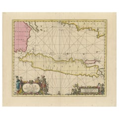
This original copperplate engraved map titled "Deuxième Carte des Isles de la Sonde" offers a rare and valuable 18th-century French perspective on the Indonesian archipelago, focusing on the islands of Java, Bali, Lombok, and the southern coast of Borneo. Published in Paris circa 1750, this map was included in Jacques Nicolas Bellin’s influential cartographic output for the monumental travel compilation L’Histoire Générale des Voyages, one of the most comprehensive geographical publications of the Enlightenment era.
The map presents the islands in clear, legible French script with geographical features meticulously labeled, including mountains, rivers, principal settlements, and coastal contours. Java is the central focus, richly detailed with numerous inland towns such as Batavia (modern Jakarta), Bantam, Surabaya, and Mataram, as well as smaller ports, mountain ranges, and rivers that were key to both indigenous societies and European colonial trade. The neighboring island of Bali is shown with surprisingly accurate coastal outlines, and the surrounding islands of Lombok, Madura, and parts of Sumatra are also identified.
To the north, the map details the southern coast of Borneo, identifying native groups such as the Biayos, and referencing the “terre de Condawangsa,” with interior areas noted as scarcely known or inhabited by “savage” tribes, reflecting 18th-century European colonial assumptions. The cartouche is elegantly framed in a red border and positioned in the upper left. The latitude and longitude markings are based on both the Paris and Ferro meridians, an indication of contemporary French geographical conventions.
Condition summary:
This hand-colored map remains in fair condition with original outline color, a strong impression. Right margin short. Vertical and horizontal folds are visible as issued. Some minor edge wear and toning consistent with age.
Framing suggestions:
This antique map will look its best in a classic dark wooden or ebonized frame with a neutral off-white or ivory mat to draw out the delicate pastel tones of the hand coloring. It is an ideal acquisition for collectors of Southeast Asian colonial cartography, French Enlightenment-era atlases, or those with an interest in the history of the Indonesian archipelago and the maritime spice trade.
- Dimensions:Height: 10.63 in (27 cm)Width: 14.38 in (36.5 cm)Depth: 0.01 in (0.2 mm)
- Materials and Techniques:Paper,Engraved
- Place of Origin:
- Period:
- Date of Manufacture:circa 1750
- Condition:This hand-colored map remains in fair condition with original outline color, a strong impression. Right margin short. Vertical and horizontal folds are visible as issued. Some minor edge wear and toning consistent with age.
- Seller Location:Langweer, NL
- Reference Number:Seller: M-16271stDibs: LU3054345460272
About the Seller
5.0
Recognized Seller
These prestigious sellers are industry leaders and represent the highest echelon for item quality and design.
Platinum Seller
Premium sellers with a 4.7+ rating and 24-hour response times
Established in 2009
1stDibs seller since 2017
2,852 sales on 1stDibs
Typical response time: 1 hour
- ShippingRetrieving quote...Shipping from: Langweer, Netherlands
- Return Policy
More From This Seller
View AllAntique Map of Java and Madura Island, Indonesia, c.1760
Located in Langweer, NL
Antique map titled 'Idee de l'Isle de Java.'
Well engraved and attractive chart of the island shows all principal harbors and coastal details, plus rivers, mountains and volcanoe...
Category
Antique 18th Century Maps
Materials
Paper

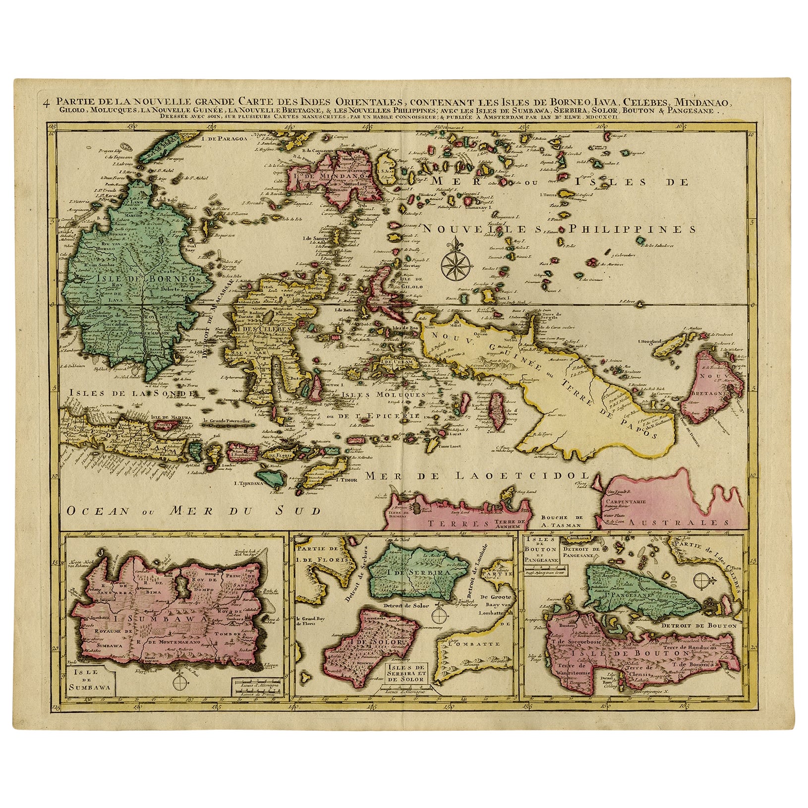
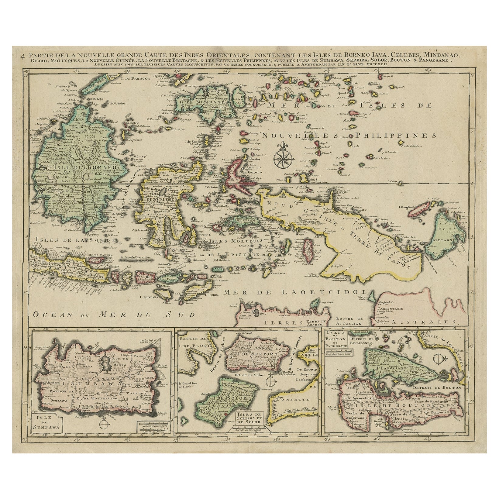
Old Map of Indonesian Islands Borneo, Celebes, New Guinea
New Britain, 1792
Located in Langweer, NL
Antique map titled 'Partie de la Nouvelle Grande Carte des Indes Orientales, contenant les Isles de Borneo, Iava, Celebes, Mindanao (..)'.
Detailed map of the Indonesian islands Bo...
Category
Antique 1790s French Maps
Materials
Paper

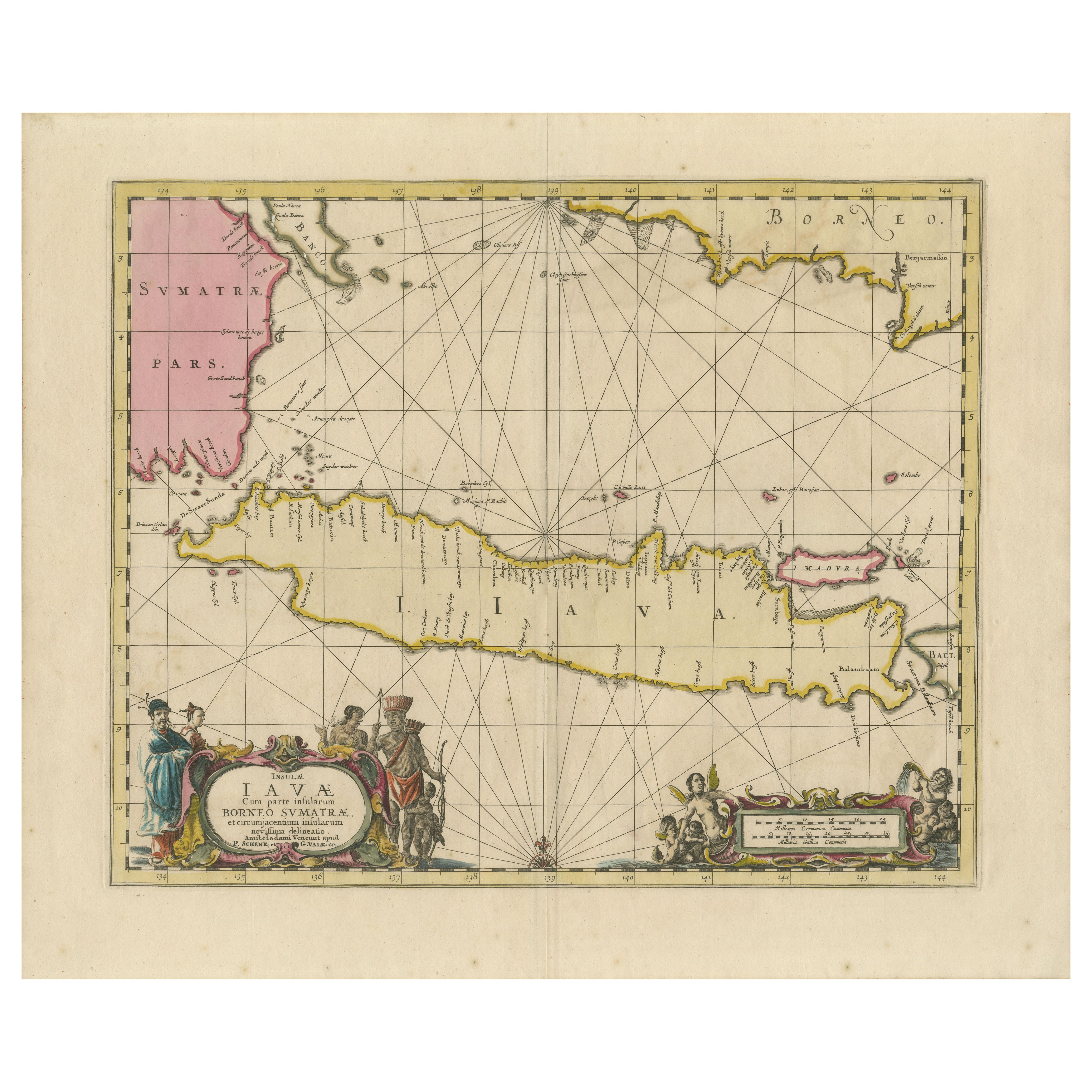
Antique Map of Java, Sumatra
Borneo – Dutch East Indies Sea Chart c.1700
Located in Langweer, NL
Title: Antique Map of Java, Sumatra & Borneo – Dutch East Indies Sea Chart c.1700
This original antique sea chart depicts the island of Java in full length, shown together with adja...
Category
Antique Early 18th Century Dutch Maps
Materials
Paper
Old Map of the East Indonesian Islands Borneo, Celebes, New Guinea, Bali, 1792
Located in Langweer, NL
Antique map titled 'Partie de la Nouvelle Grande Carte des Indes Orientales, contenant les Isles de Borneo, Iava, Celebes, Mindanao (..)'.
Detailed map of the Indonesian islands ...
Category
Antique 1790s Maps
Materials
Paper

Antique French Map of Java, Indonesia by Chatelain,
1719
Located in Langweer, NL
Antique map titled 'Carte de l'Ile de Java: Partie Occidentale, Partie Orientale, Dressee tout Nouvellement Sur Les Memoires Les Plus Exacts (..)'. This beautiful map of Java (Indone...
Category
Antique Early 18th Century Maps
Materials
Paper

$1,847 Sale Price
45% Off
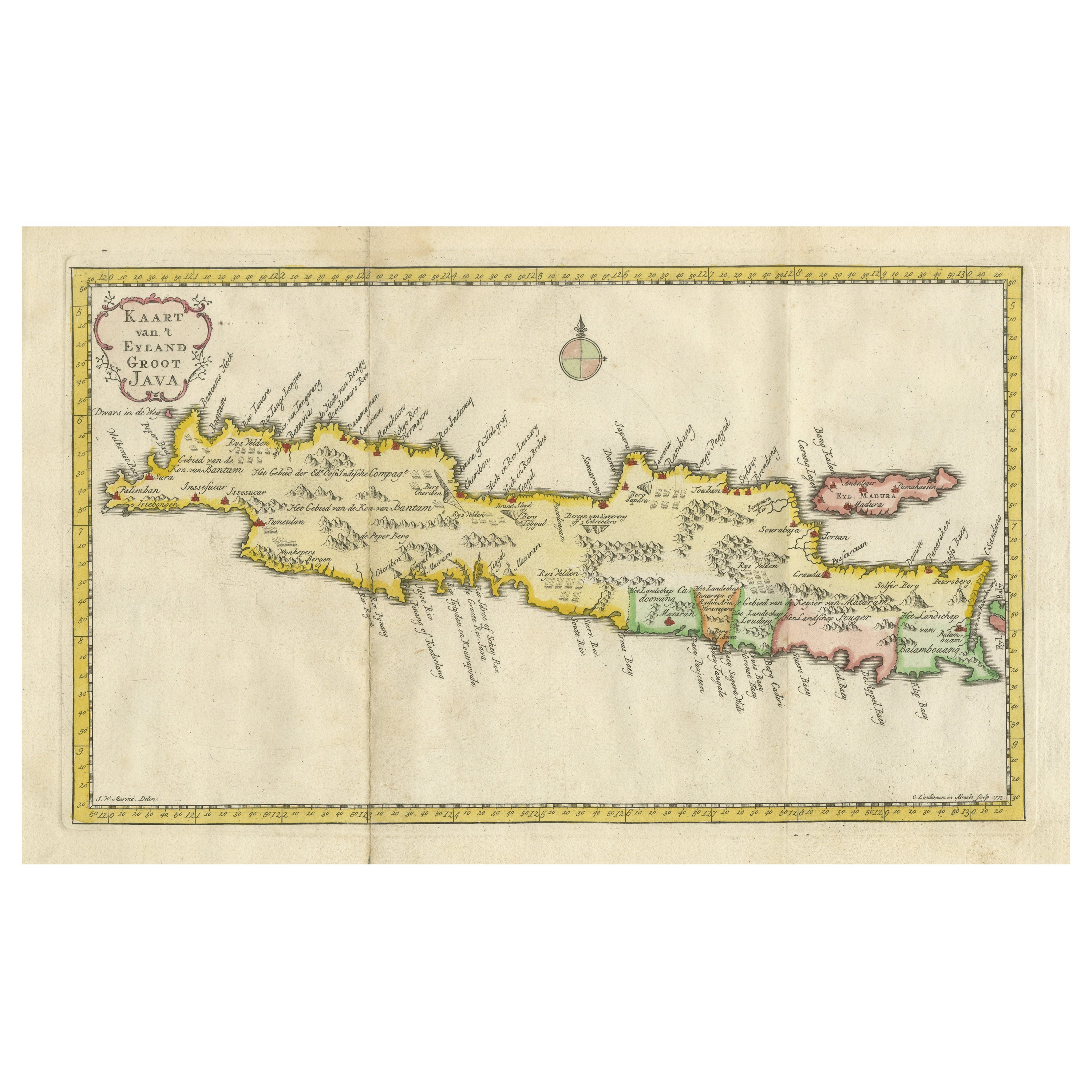
Scarce Antique Map of the Island of Java, Indonesia
Located in Langweer, NL
Title: "Kaart van 't Eyland Groot Java: Antique Map of Java, Indonesia"
Description: This antique map, titled "Kaart van 't Eyland Groot Java," offers a rare and valuable depiction ...
Category
Antique Late 18th Century Maps
Materials
Paper
$627 Sale Price
20% Off
You May Also Like
West Coast of Africa, Guinea
Sierra Leone: An 18th Century Map by Bellin
By Jacques-Nicolas Bellin
Located in Alamo, CA
Jacques Bellin's copper-plate map entitled "Partie de la Coste de Guinee Dupuis la Riviere de Sierra Leona Jusquau Cap das Palmas", depicting the coast of Guinea and Sierra Leone in ...
Category
Antique Mid-18th Century French Maps
Materials
Paper

Antique French Map of Asia Including China Indoneseia India, 1783
Located in Amsterdam, Noord Holland
Very nice map of Asia. 1783 Dedie au Roy.
Additional information:
Country of Manufacturing: Europe
Period: 18th century Qing (1661 - 1912)
Condition: Overall Condition B (Good Used)...
Category
Antique 18th Century European Maps
Materials
Paper

$486 Sale Price
40% Off
Map of the East Indies: An Original 18th Century Hand-colored Map by E. Bowen
Located in Alamo, CA
This is an original 18th century hand-colored map entitled "An Accurate Map of the East Indies Exhibiting the Course of the European Trade both on the Continent and Islands" by Emanu...
Category
Mid-18th Century Old Masters Landscape Prints
Materials
Engraving

West Coast of Africa; Guinea
Sierra Leone: Bellin 18th Century Map
Located in Alamo, CA
This is a Jacques Bellin copper-plate map entitled "Partie de la Coste de Guinee Dupuis la Riviere de Sierra Leona Jusquau Cap das Palmas", depicting the coast of Guinea and Sierra L...
Category
1740s Old Masters Landscape Prints
Materials
Engraving

Antique 1803 Italian Map of Asia Including China Indoneseia India
Located in Amsterdam, Noord Holland
Antique 1803 Italian Map of Asia Including China Indoneseia India
Very nice map of Asia. 1803.
Additional information:
Type: Map
Country of Manufacturing: Europe
Period: 19th centu...
Category
Antique 19th Century European Maps
Materials
Paper

$438 Sale Price
39% Off
Southern Greece: A Large 17th C. Hand-colored Map by Sanson and Jaillot
By Nicolas Sanson
Located in Alamo, CA
This large original hand-colored copperplate engraved map of southern Greece and the Pelopponese Peninsula entitled "La Moree Et Les Isles De Zante, Cefalonie, Ste. Marie, Cerigo & C...
Category
Antique 1690s French Maps
Materials
Paper

More Ways To Browse
18th Century Colonial Furniture
Bali Furniture
Bali Antique
French Colonial Furniture
Antique Victorian Dining Tables
Italian Plastic Chairs
Black Crystal Glasses
French Mid Century Modern Rug
China Silk Rug
Chrome Glass Coffee Tables
Antique Italian Chairs
Antique Walnut Bar
Beni Ourain Rugs
French Iron And Glass Table
Glass Top Wood Base Coffee Tables
T Chair
Antique Silver Basket
Antique Walkers