Items Similar to Jerusalem, Holy City View – Early Renaissance Woodcut, c.1560

Want more images or videos?
Request additional images or videos from the seller
1 of 10
Jerusalem, Holy City View – Early Renaissance Woodcut, c.1560
$740.41
£553.25
€620
CA$1,021.29
A$1,118.79
CHF 588.89
MX$13,353.07
NOK 7,506.83
SEK 6,862.38
DKK 4,723.91
About the Item
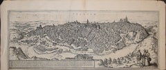
Jerusalem, Holy City View – Early Renaissance Woodcut, c.1560
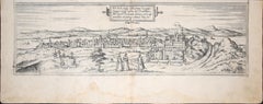
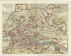
This rare and evocative Renaissance woodcut depicts the Holy City of Jerusalem as imagined in early modern Europe, shown as a fortified, densely built sacred city surrounded by hills, valleys, and biblical landmarks. The view presents Jerusalem as the spiritual and historical heart of the Holy Land, combining biblical tradition, medieval cartographic conventions, and early Renaissance city imagery.
The city is rendered in a panoramic bird’s-eye perspective, with major sacred sites clearly identified, including the Temple of Solomon, the Holy Sepulchre, Mount Zion, the Valley of Jehoshaphat, and the Garden of Gethsemane. Towers, gates, walls, domes, and churches fill the composition, creating a powerful visual narrative of Jerusalem as both an earthly city and a divine center. The emphasis is symbolic rather than topographically exact, reflecting how Jerusalem was understood and revered in 16th-century Christian Europe.
The French title at the top identifies Jerusalem as the former metropolitan city of the Kingdom of the Jews and notes its later status as a Roman colony, anchoring the image firmly within biblical and classical historical tradition. Below the city view, extensive French text discusses Jericho and biblical geography, accompanied by a decorative botanical woodcut, a characteristic feature of Renaissance cosmographical and biblical publications.
This print originates from a mid-16th-century French cosmographical or biblical work, influenced by Sebastian Münster and related Renaissance scholars. The woodcut technique, Gothic-Renaissance lettering, and dense narrative imagery place the print firmly within the great age of European biblical geography and early historical illustration.
Highly decorative and rich in symbolic detail, this view of Jerusalem is equally appealing to collectors of early Holy Land imagery, Renaissance prints, and biblical cartography, as well as to interior designers seeking a visually striking and intellectually layered historical work on paper.
Condition report
Good condition for a 16th-century woodcut. Central vertical fold as issued. General age toning and some discoloration consistent with period. Light creasing and minor edge wear. Text and image clear and well preserved. No major losses.
Framing tips
This print benefits from a wide off-white or light parchment-colored mat to emphasize the historic paper tone. A dark walnut, ebonized, or softly gilt frame enhances the Renaissance character and architectural detail. Particularly effective as a statement piece in a study, library, or classical interior.
Technique
Woodcut
Maker: Sebastian Münster (1488–1552) was a German cartographer/scholar, even when the book edition (and many surviving sheets) were printed in Basel and sometimes in French., c.1560
Keywords: Jerusalem, Holy Land, Holy City, Renaissance Jerusalem view, antique Jerusalem print, biblical Jerusalem, Holy Sepulchre, Temple of Solomon, Mount Zion, Gethsemane, Valley of Jehoshaphat, Jericho, biblical geography, early Holy Land map, 16th century woodcut, Renaissance woodcut, Sebastian Münster circle, antique religious print, Christian cartography, biblical city view, antique Israel print, Palestine, sacred geography, early modern cosmography
- Dimensions:Height: 12.01 in (30.5 cm)Width: 15.24 in (38.7 cm)Depth: 0.01 in (0.2 mm)
- Materials and Techniques:Paper,Engraved
- Place of Origin:
- Period:
- Date of Manufacture:circa 1560
- Condition:Good condition for a 16th-century woodcut. Central vertical fold as issued. General age toning and some discoloration consistent with period. Light creasing and minor edge wear. Text and image clear and well preserved. No major losses.
- Seller Location:Langweer, NL
- Reference Number:Seller: BG-14153-41stDibs: LU3054348018012
About the Seller
5.0
Recognized Seller
These prestigious sellers are industry leaders and represent the highest echelon for item quality and design.
Platinum Seller
Premium sellers with a 4.7+ rating and 24-hour response times
Established in 2009
1stDibs seller since 2017
2,809 sales on 1stDibs
Typical response time: 1 hour
- ShippingRetrieving quote...Shipping from: Langweer, Netherlands
- Return Policy
More From This Seller
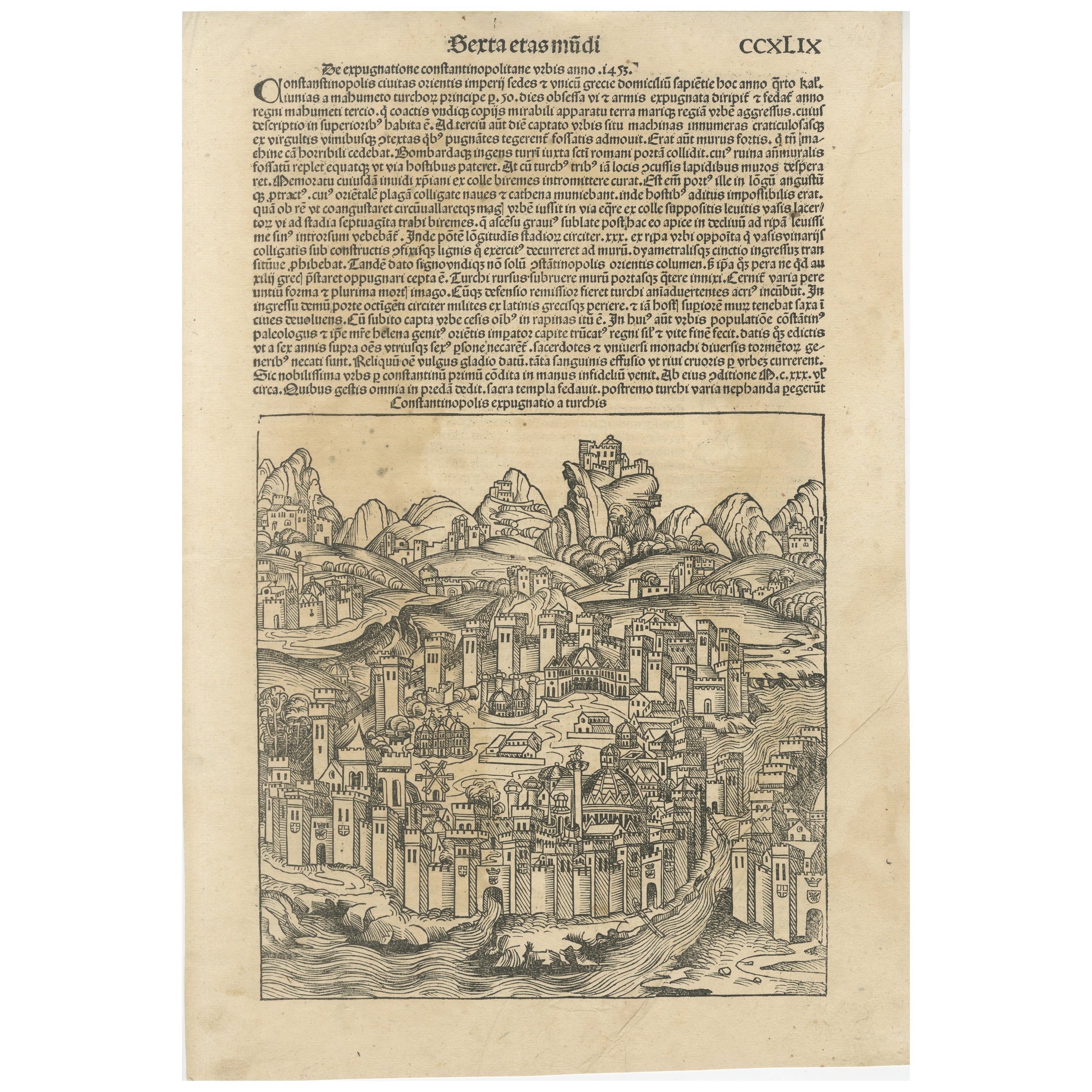
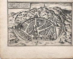
View AllRare 1493 Woodcut of Constantinople from Hartmann Schedel
s Nuremberg Chronicle
Located in Langweer, NL
Title: Constantinopolis Expugnatio a Turchis - Hartmann Schedel, 1493
This woodcut view of Constantinople is from Hartmann Schedel's 'Nuremberg Chronicle' (Liber Chronicarum), publi...
Category
Antique 15th Century and Earlier German Prints
Materials
Paper
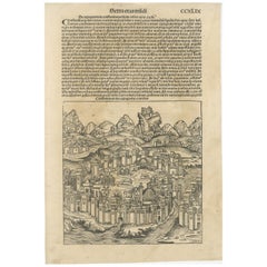
$945 Sale Price
20% Off
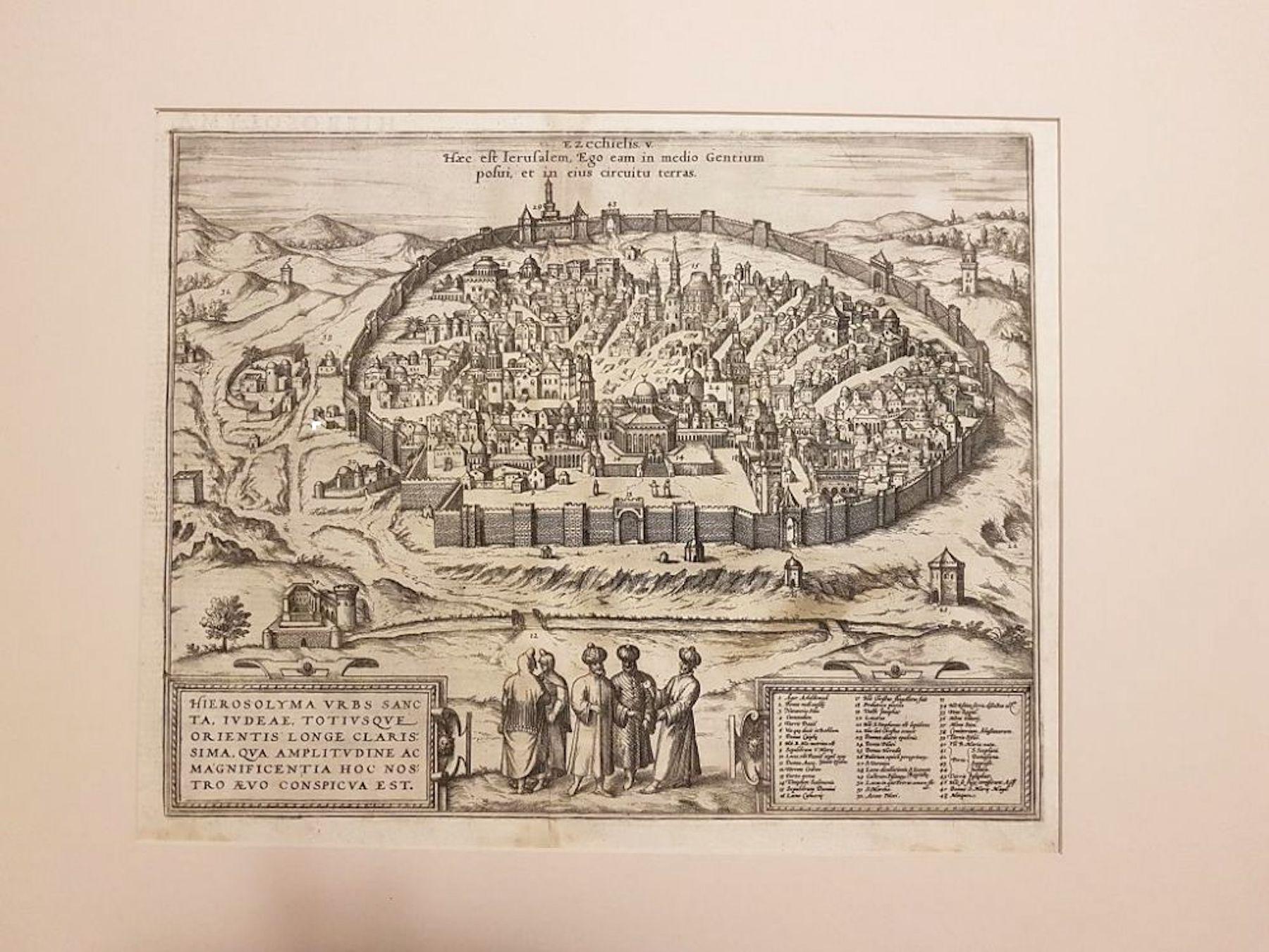
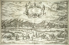
1720 Weigel Engraving of Jerusalem: A Biblical View from Josephus
Perspective
Located in Langweer, NL
1720 Weigel Map of Jerusalem Based on Josephus' Writings
This intricate 1720 bird's-eye view map of ancient Jerusalem by I.H. Coccejo, engraved by Christoph Weigel, offers a fasc...
Category
Antique 1720s Maps
Materials
Paper

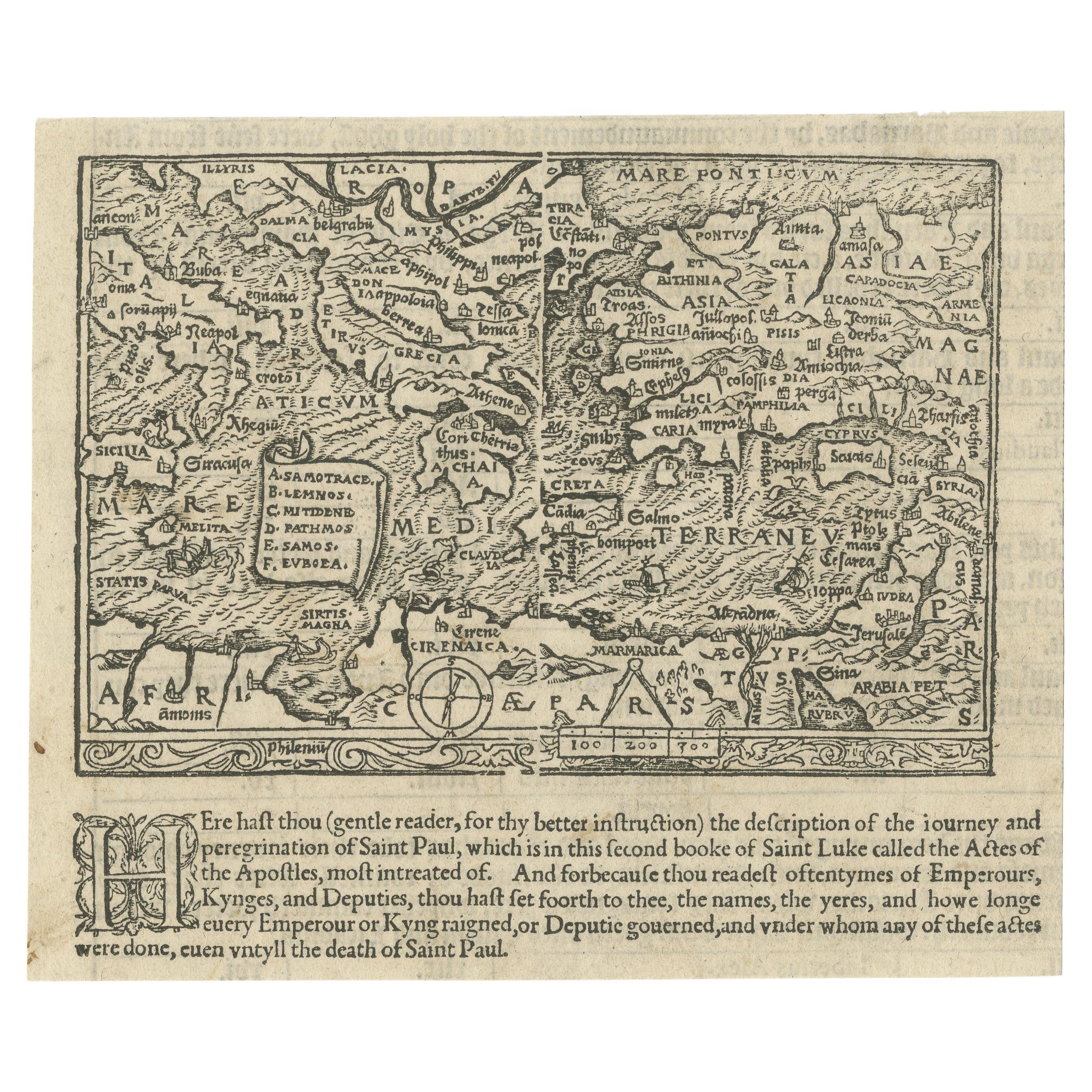
Rare and Interesting Small Antique Woodcut Map of the Mediterranean, 1568
Located in Langweer, NL
Very rare untitled antique woodcut map showing the region of the missionary journeys of Apostle Paul. It shows the Mediterranean with Greece, Asia Minor (Turkey), Northern Africa, So...
Category
Antique 16th Century British Maps
Materials
Paper
$2,507 Sale Price
25% Off
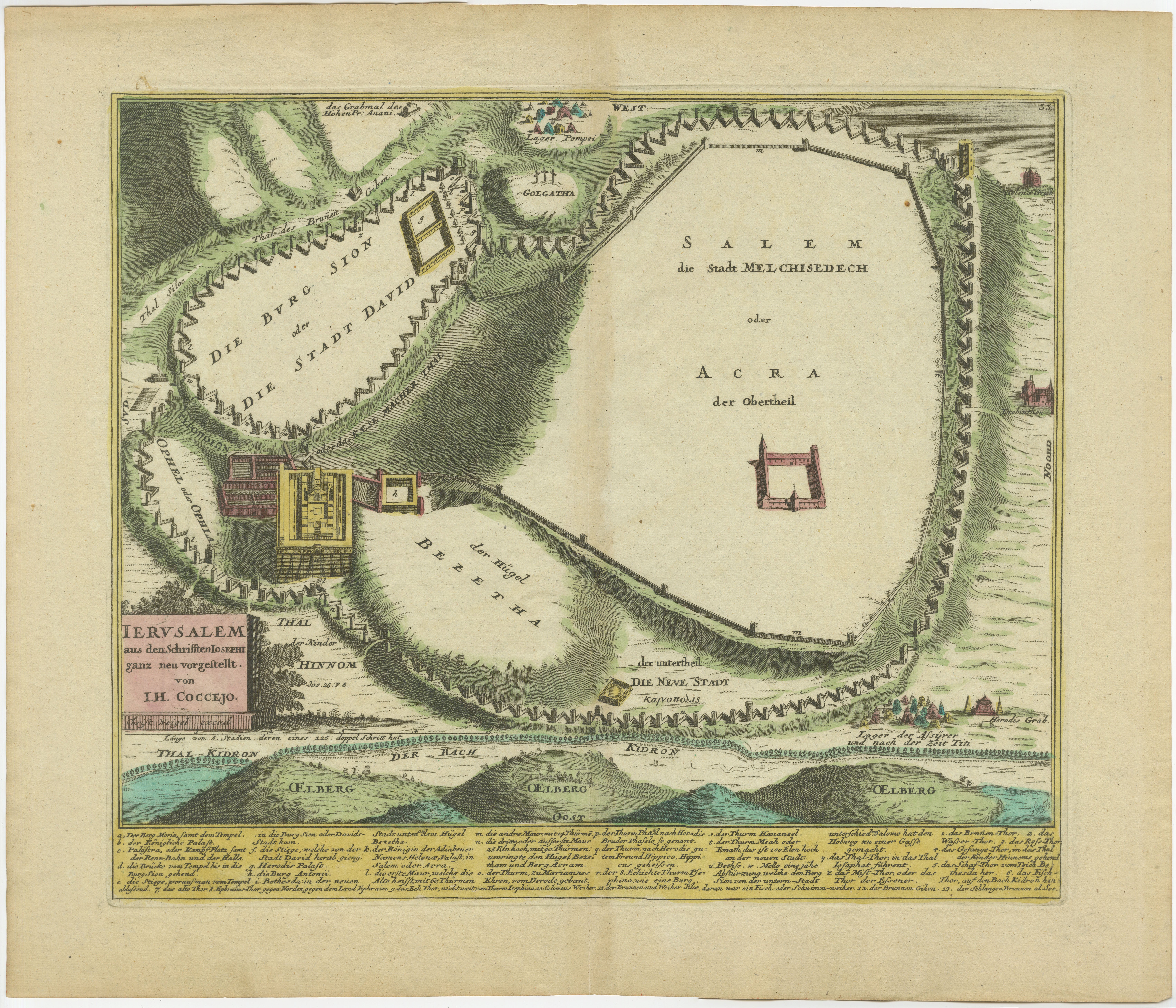
Spectacular Antique Original Engraving of a Town Plan of Jerusalem, 1708
Located in Langweer, NL
Description: Antique map titled 'Erster Abriss der Stadt Jerusalem wie sie Furnemblich zur Zeit des Hernn Christi beschaffen (..).'
Spectacular town plan...
Category
Antique Early 1700s Maps
Materials
Paper

Rare 1572 Map of Ancient Rome with Monuments by Ligorio, Braun
Hogenberg
Located in Langweer, NL
Rare 1572 Map of Ancient Rome with Monuments by Ligorio, Braun & Hogenberg
This remarkable 16th-century map, *Urbis Romae Situs cum ils quae adhuc Conspiciuntur Veter. Monumet Rel...
Category
Antique 16th Century German Maps
Materials
Paper
$1,815 Sale Price
20% Off
Antique Map of the Holy Land, with vignette of the Garden of Eden
Located in Langweer, NL
Antique map titled 'Hondius his Map of Paradise'. Beautiful map of the region bounded by the Holy Land. Syria, Mesopotamia, Chaldea and part of Arabia. W...
Category
Antique Mid-17th Century Maps
Materials
Paper
$458 Sale Price
20% Off
You May Also Like
Jerusalem, Antique Map from "Civitates Orbis Terrarum" - 1572-1617
By Franz Hogenberg
Located in Roma, IT
Braun G., Hogenberg F., Jerusalem, from the collection Civitates Orbis Terrarum, Cologne, T. Graminaeus, 1572-1617.
Image dimensions: cm 32.8 x 41; dimensions: cm 41 x 54; Passepart...
Category
16th Century Landscape Prints
Materials
Etching
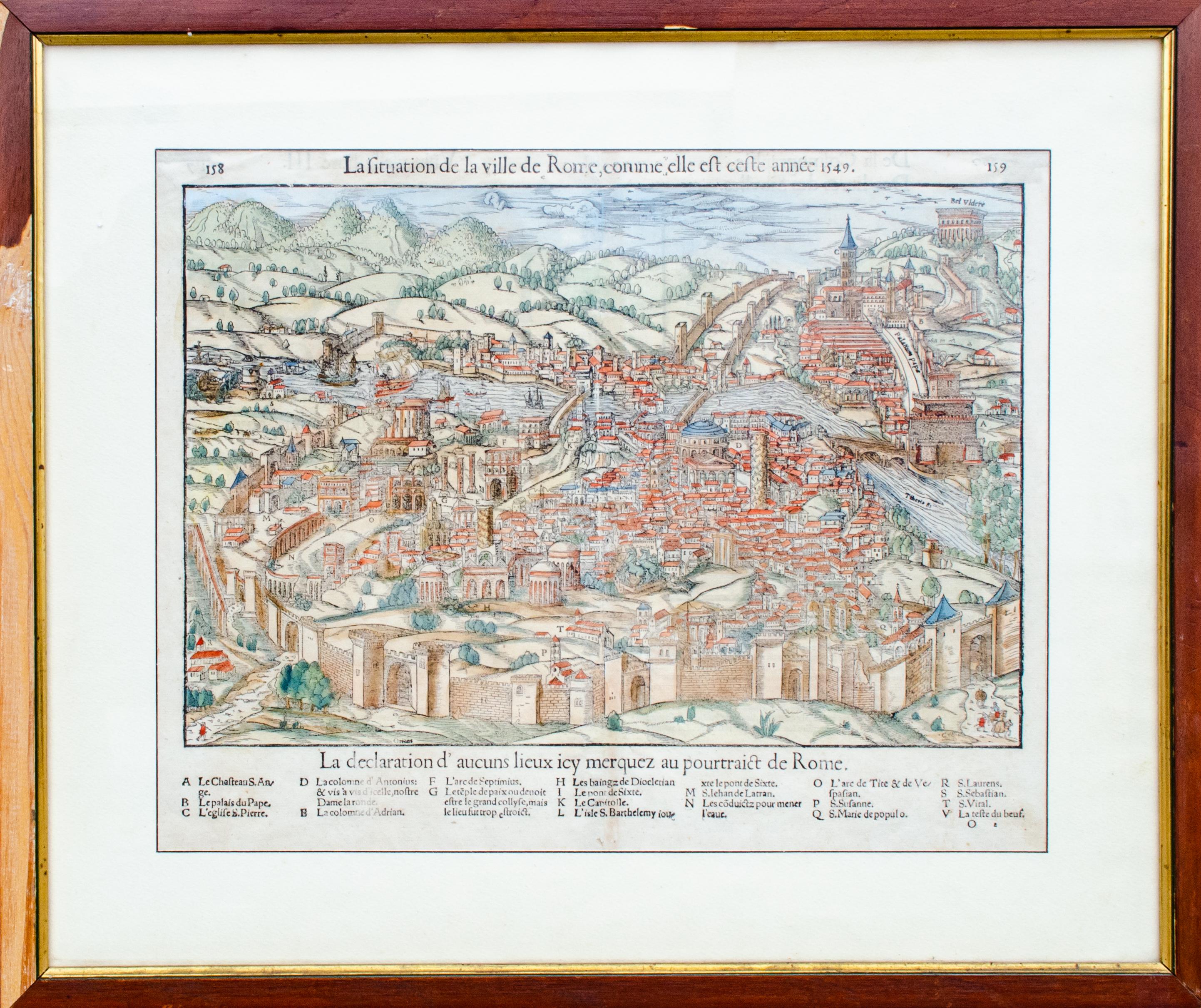
Antique Map of The City of Rome by Sebastian Münster, 1549
By Sebastian Münster
Located in New York, NY
Sebastian Münster (German, 1488-1552)
LA SITUATION DE LA VILLE DE ROME
Antique Map of Rome, 1549
Possibly printed in 1964
Print on paper
Publisher:...
Category
1960s Realist Figurative Prints
Materials
Woodcut
Toledo, Map from "Civitates Orbis Terrarum" - by F. Hogenberg - 1575
By Franz Hogenberg
Located in Roma, IT
Braun G., Hogenberg F., "Toledo", from the collection "Civitates Orbis Terrarum", Cologne, T. Graminaeus, 1572-1617. Image Dim: cm 19 x 48 , Dim: cm 22. 5 x 52.5 .
Very nice B/W Aquatint representing a View of Toledo...
Category
16th Century Figurative Prints
Materials
Etching, Aquatint
Map of Nemavsus - Etching by George Braun - Late 16th Century
Located in Roma, IT
This Map of Nemavsus is an original etching realized by George Braun (1541 – 1622)
The state of preservation of the artwork is good and aged on the edges of the sheet with a few sm...
Category
16th Century More Prints
Materials
Etching
Granada, Map from "Civitates Orbis Terrarum" - by F.Hogenberg - 1575
By Franz Hogenberg
Located in Roma, IT
"Granada", from the collection "Civitates Orbis Terrarum", Cologne, T. Graminaeus, 1575.
Very nice B/W Aquatint, representing a View of Granada, from the East, which was perhaps t...
Category
16th Century Figurative Prints
Materials
Etching, Aquatint
Buda, Antique Map from "Civitates Orbis Terrarum" - 1572-1617
By Franz Hogenberg
Located in Roma, IT
Braun G., Hogenberg F., Buda, from the collection Civitates Orbis Terrarum, Cologne, T. Graminaeus, 1572-1617.
Very fine B/W aquatint showing a view of Buda, an actual part of Budap...
Category
16th Century Landscape Prints
Materials
Etching