Items Similar to Large 1693 Maritime Map of Irish Sea, West Coasts of Ireland, England, Scotland


Want more images or videos?
Request additional images or videos from the seller
1 of 10
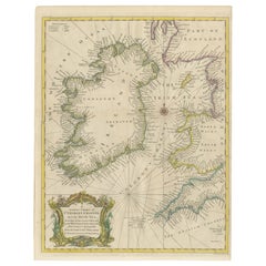
Large 1693 Maritime Map of Irish Sea, West Coasts of Ireland, England, Scotland
$2,339.92
$3,119.8925% Off
£1,734.03
£2,312.0325% Off
€1,950
€2,60025% Off
CA$3,197.98
CA$4,263.9825% Off
A$3,481.26
A$4,641.6825% Off
CHF 1,847.86
CHF 2,463.8125% Off
MX$41,887.10
MX$55,849.4625% Off
NOK 23,414.85
NOK 31,219.8025% Off
SEK 21,454.62
SEK 28,606.1625% Off
DKK 14,853.73
DKK 19,804.9825% Off
About the Item
This large late-17th-century sea chart is titled *Carte Générale des Costes d’Irlande, et des Costes Occidentales d’Angleterre avec une Partie de celles d’Ecosse*, showing the entire coastline of Ireland together with the western coasts of England and Wales and parts of western Scotland. It was first published in 1693 as part of *La Neptune François*, a monumental French maritime atlas engraved and issued in Amsterdam by *Pieter Mortier* after designs by *Alexis-Hubert Jaillot*.
The chart is conceived as a practical navigational tool. The Irish Sea and surrounding waters are densely filled with depth soundings, while extensive rhumb lines radiate across the sheet to aid the plotting of courses. Coastal outlines are carefully rendered, with bays, headlands, islands, ports, and anchorages clearly identified. A navigational key explains the nature of the coastal terrain, an important aid for mariners approaching unfamiliar shores. An inset map focuses on the area around Chester, showing the course of the River Dee and its approaches in greater detail.
Produced during a period of rapid advancement in hydrographic knowledge, the map reflects a coordinated French effort to improve maritime navigation. The project was initiated under the direction of Jean-Baptiste Colbert, minister to Louis XIV, with the aim of providing reliable and standardized sea charts for naval and commercial use. Compared to earlier coastal maps, this chart demonstrates a marked improvement in accuracy, consistency, and practical usability.
Printed on heavy paper and originally issued with hand coloring, the chart combines technical precision with a restrained decorative quality typical of late-seventeenth-century French cartography. Its careful engraving, clear lettering, and systematic presentation of navigational information made it an indispensable working document for contemporary sailors navigating the complex and often hazardous coasts of Ireland, Britain, and the Irish Sea.
Today, this chart is valued not only as a rare survival from one of the most important early sea atlases, but also as a vivid document of European maritime knowledge at the height of France’s naval ambitions. It appeals equally to collectors of early nautical charts, historians of cartography, and those interested in the maritime history of the British Isles.
- Dimensions:Height: 24.81 in (63 cm)Width: 37.01 in (94 cm)Depth: 0.01 in (0.2 mm)
- Materials and Techniques:Paper,Engraved
- Place of Origin:
- Period:1690-1699
- Date of Manufacture:1693
- Condition:The map is in good condition, printed on thick paper with contemporary hand coloring. It shows some age-related wear, but the detailed lines, labels, and depth soundings are clear and well-preserved, making it a valuable historical document.
- Seller Location:Langweer, NL
- Reference Number:Seller: BG-13754-11stDibs: LU3054340539142
About the Seller
5.0
Recognized Seller
These prestigious sellers are industry leaders and represent the highest echelon for item quality and design.
Platinum Seller
Premium sellers with a 4.7+ rating and 24-hour response times
Established in 2009
1stDibs seller since 2017
2,816 sales on 1stDibs
Typical response time: 1 hour
- ShippingRetrieving quote...Shipping from: Langweer, Netherlands
- Return Policy
More From This Seller
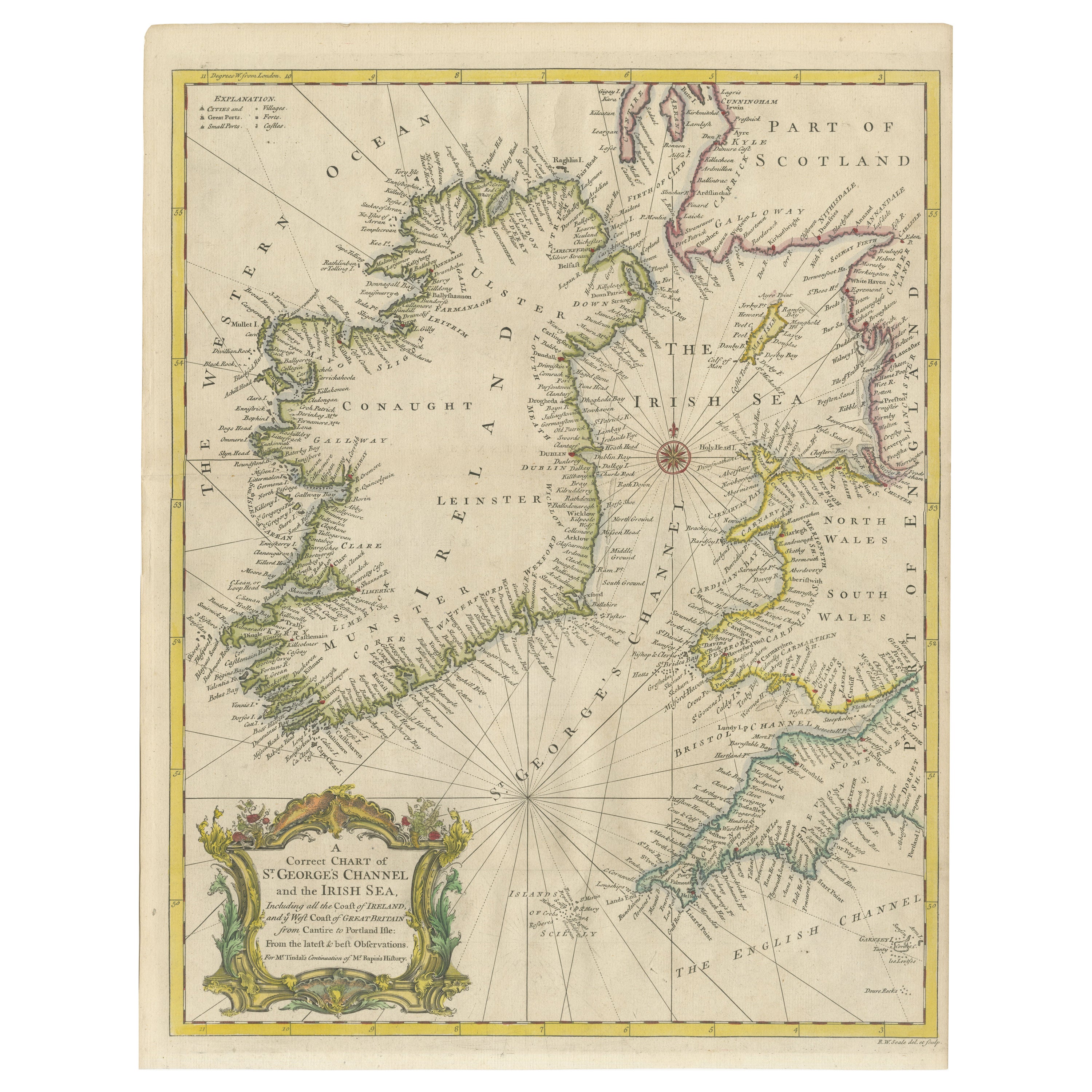
View AllHand-colored Nautical Chart: St. George
s Channel and the Irish Sea, 1744
Located in Langweer, NL
The map was engraved by Richard William Seale, a notable British engraver. This map is a fine example of 18th-century cartography, particularly focused on maritime navigation.
The m...
Category
Antique 1740s Maps
Materials
Paper
$633 Sale Price
20% Off
Map of Ireland: Early 19th Century - from the 1802 Tardieu Atlas
Located in Langweer, NL
Antique Map Description
**Title:** Carte d'Irlande
**Publication Details:**
- **Atlas Title:** Nouvel Atlas Universel de Géographie Ancienne et Moderne
- **Purpose:** For the Nouve...
Category
Antique Early 1800s Maps
Materials
Paper

$422 Sale Price
20% Off
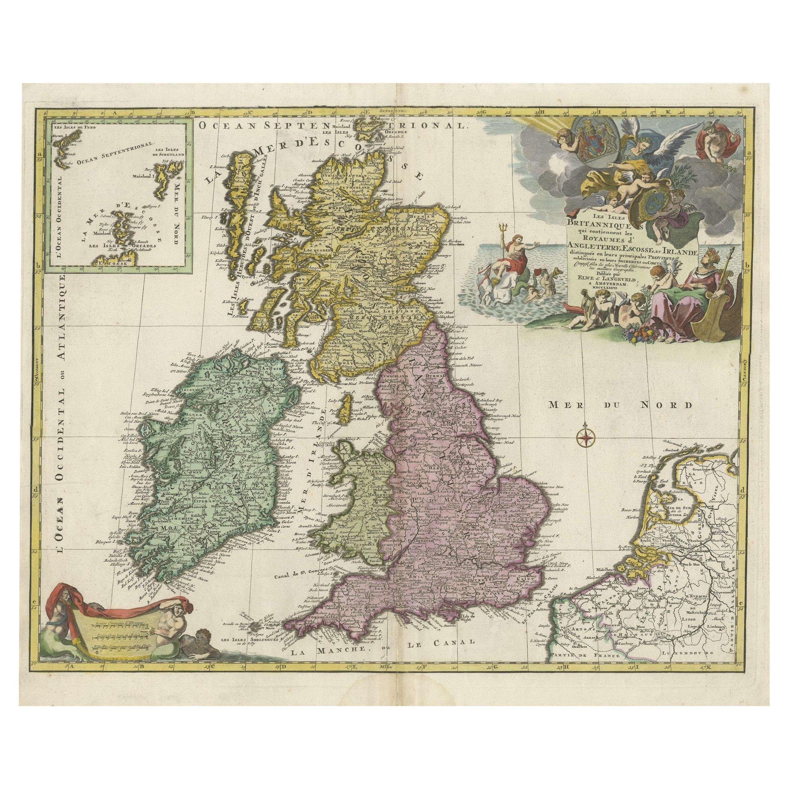
Old Map of the UK
Ireland, Insets of Orkney, Shetland and Faroe Islands, 1786
Located in Langweer, NL
Title: "Les Isles Britanniques qui contiennent les Royaumes d'Angleterre, Escosse, et Irlande".
Hand-colored engraved map with 2 (large) decorative cartouches, inset map of the Ork...
Category
Antique 1780s Maps
Materials
Paper
Antique Map of the British Isles by H. Chatelain, 1719
By Henri-Abraham Chatelain
Located in Langweer, NL
Beautiful hand colored large format map of the British Isles, with large insets of the Eastern and Western Hemispheres and the coats of arms for Engl...
Category
Antique Early 18th Century Maps
Materials
Paper

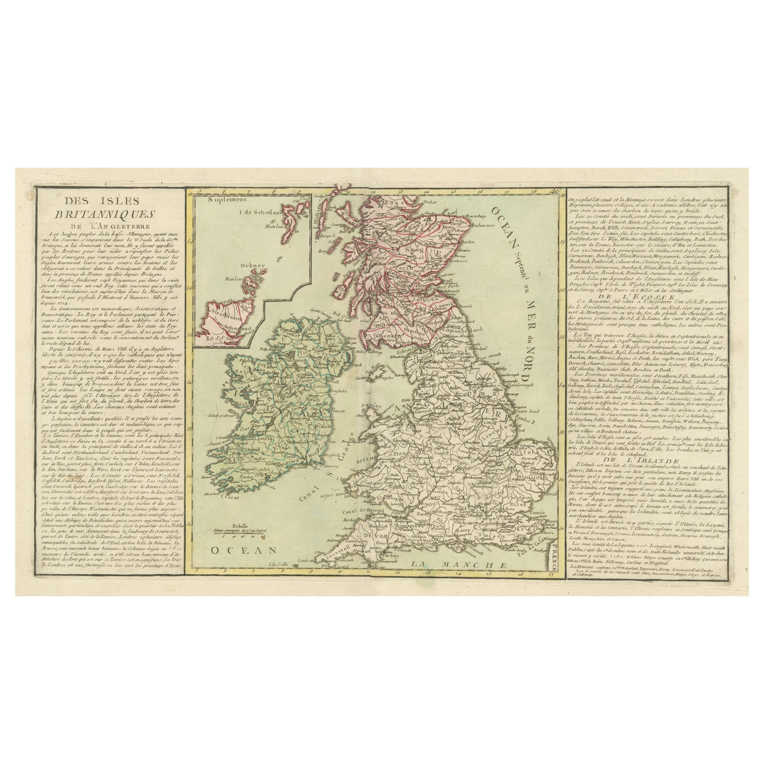
Original Antique Map of the British Isles Surrounded by Text
Located in Langweer, NL
Antique map titled 'Des Isles Britanniques'. Original antique map of the British isles. This map is divided in to three major regions of the 18th century United Kingdom: England, Ire...
Category
Antique Late 18th Century Maps
Materials
Paper

$355 Sale Price
20% Off
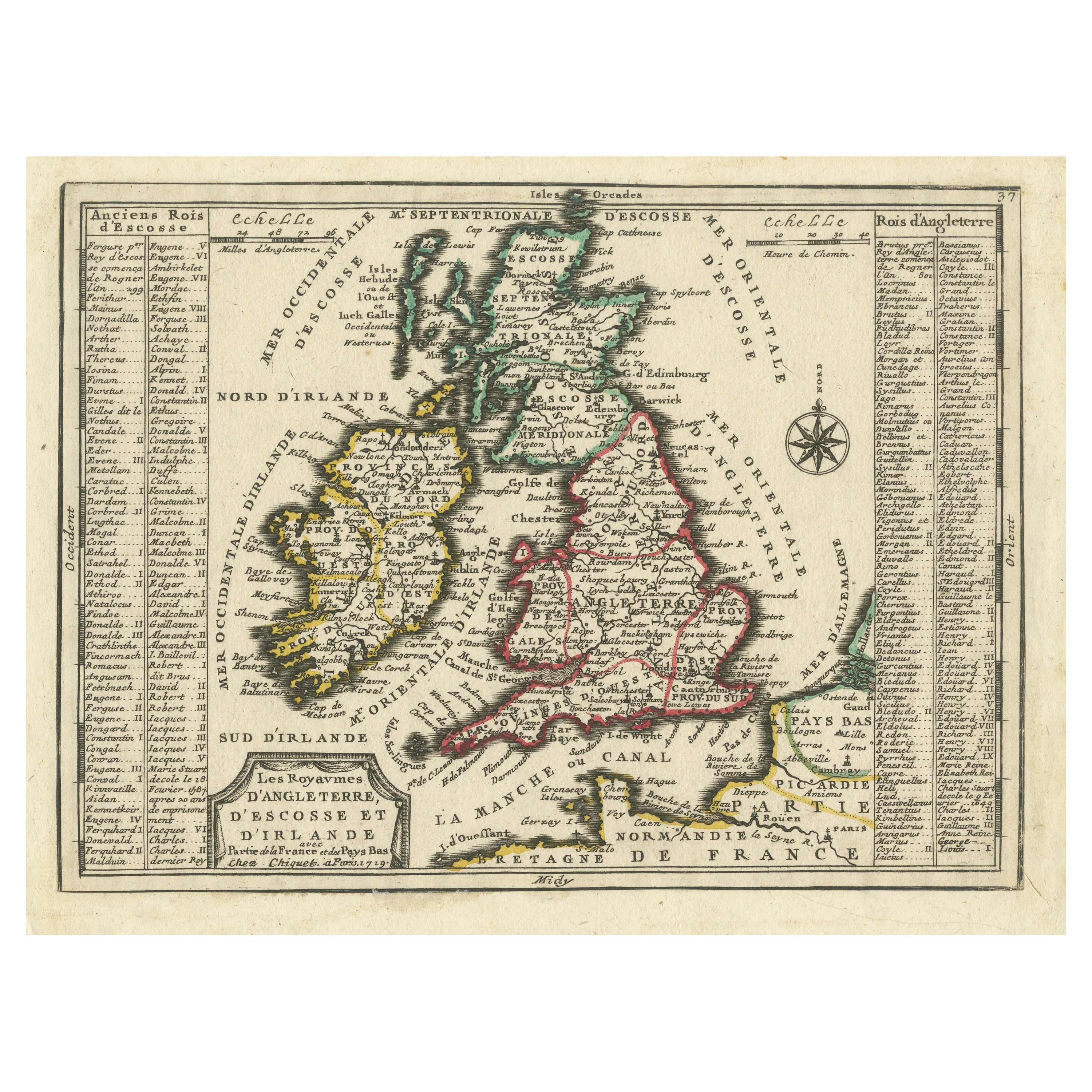
Map of the British Isles with Historical Kings, 1719
Located in Langweer, NL
This antique map, titled "Les Royaumes d'Angleterre d'Escosse et d'Irlande," offers a detailed view of the British Isles, including England, Wales, Scotland, and Ireland. Additionall...
Category
Antique Early 18th Century Maps
Materials
Paper
$422 Sale Price
20% Off
You May Also Like
England, Scotland
Ireland: A Hand Colored Map of Great Britain by Tirion
By Isaak Tirion
Located in Alamo, CA
This is a hand-colored double page copperplate map of Great Britain entitled "Nieuwe Kaart van de Eilanden van Groot Brittannien Behelzende de Kon...
Category
Antique Mid-18th Century Dutch Maps
Materials
Paper

$700 Sale Price
20% Off
1585 Mercator Map of Ireland, Entitled "Irlandiae Regnvm, " Hand Colored Ric0006
Located in Norton, MA
1585 Mercator map of Ireland, entitled
"Irlandiae Regnvm."
Hand Colored
Description: Published in Amsterdam by Mercator/Hondius ca. 1585.
Artists and Engravers: 1585 Mercator map of Ireland, entitled "Irlandiae Regnvm." Copperplate engraving on verge type hand laid paper with watermark. Description: Published in Amsterdam by Mercator/Hondius ca. 1585.Artists and Engravers: Mercator was born in Rupelmonde in Flanders and studied in Louvain under Gemma Frisius, Dutch writer, astronomer and mathematician. The excellence of his work brought him the patronage of Charles V, but in spite of his favor with the Emperor he was caught up in the persecution of Lutheran protestants and charged with heresy, fortunately without serious consequences. No doubt the fear of further persecution influenced his move in 1552 to Duisburg, where he continued the production of maps, globes and instruments. Mercator's sons and grandsons, were all cartographers and made their contributions in various ways to his atlas. Rumold, in particular, was responsible for the complete edition in 1595. The map plates...
Category
Antique 16th Century Dutch Maps
Materials
Paper
Large Original Antique Map of Ireland. C.1900
Located in St Annes, Lancashire
Fabulous map of Ireland
Original color.
Engraved and printed by the George F. Cram Company, Indianapolis.
Published, C.1900.
Unframed.
Free shipping.
Category
Antique 1890s American Maps
Materials
Paper

Plymouth, England: A Hand-Colored 17th Century Sea Chart by Captain Collins
By Captain Greenvile Collins
Located in Alamo, CA
This hand-colored sea chart of the area around Plymouth, England from "Great Britain's Coasting Pilot. Being a New and Exact Survey of the Sea-Coast of England", first published in 1...
Category
Antique Late 17th Century English Maps
Materials
Paper

$2,220 Sale Price
20% Off
Southeastern Ireland: A 17th Century Hand Colored Map by Mercator and Hondius
By Gerard Mercator
Located in Alamo, CA
A 17th century copperplate hand-colored map entitled "The Second Table of Ireland, Udrone" by Gerard Mercator and Jodocus Hondius, published in Amsterdam in 1635 in 'Cosmographicall ...
Category
Antique Mid-17th Century Dutch Maps
Materials
Paper

$540 Sale Price
20% Off
Original Antique Map of Ireland- Kerry. C.1840
Located in St Annes, Lancashire
Great map of Kerry
Steel engraving
Drawn under the direction of A.Adlard
Published by How and Parsons, C.1840
Unframed.
Category
Antique 1840s English Maps
Materials
Paper

More Ways To Browse
Pair Arm Chairs
Sterling Silver Dinner Sets
United Chair Company
Italian Beech Chairs
Shirvan Rugs
Vintage Danish Tables And Chairs
1960s Glass Top Coffee Table
Black Glass Coffee Tables
Burnt Wood
Mid Century Wrought Iron Chairs
Earth Toned Rug
Black Marble Table Vintage
Goblets
Mid Century Modern Yellow Chair
Paulin Pierre
Used Pianos Pianos
18th Century Engravings
Antique Carved Wood Chair