Items Similar to Large Antique Map of Franche-Comté – Divided into Three Historic Bailliages 1681


Video Loading
Want more images or videos?
Request additional images or videos from the seller
1 of 11
Large Antique Map of Franche-Comté – Divided into Three Historic Bailliages 1681
$1,129
£837.06
€940
CA$1,550.99
A$1,693.16
CHF 891.47
MX$20,282.03
NOK 11,401.54
SEK 10,409.79
DKK 7,162.46
About the Item
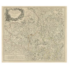
Antique Map of Franche-Comté – “La Franche Comté divisée en Trois Grands Bailliages” by Jaillot, 1681
This richly detailed antique map, titled “La Franche Comté divisée en Trois Grands Bailliages,” was published in Paris in 1681 by Alexis-Hubert Jaillot, one of the most prominent French cartographers of the late 17th and early 18th centuries. The map depicts the historical province of Franche-Comté in eastern France, divided into its three principal jurisdictions: Amont, d’Aval, and du Milieu (or de Dole), along with their subordinate bailiwicks and jurisdictions.
Drawn with exceptional clarity and artistry, the map showcases the complex administrative and judicial divisions of Franche-Comté under the Ancien Régime. Towns, rivers, forests, mountains, and fortifications are meticulously engraved, and political borders are hand-colored in outline. The region’s notable cities—such as Besançon, Dole, Vesoul, and Lons-le-Saunier—are prominently labeled. The cartouche in the upper left is adorned with decorative scrollwork, royal arms, and a dedication to Monseigneur le Dauphin, indicating its official and prestigious character.
Geographically, the map extends from Lorraine in the north to Bresse and Savoy in the south, and from Burgundy in the west to the Swiss territories of Neuchâtel and Geneva in the east. This includes part of the Jura Mountains and the area around Lake Neuchâtel. The inclusion of neighboring counties such as Neufchastel and Montbéliard offers a broader view of the region’s strategic position between France and the Swiss Confederacy.
Jaillot was known for reworking the earlier maps of Nicolas Sanson, often enlarging and enriching them for royal and scholarly audiences. This map, engraved by order of the King and revised by the cartographic academy, reflects both scholarly rigor and decorative finesse, making it highly desirable for collectors of French regional cartography.
Condition: Good condition. Strong impression on laid paper with wide margins. Original hand color in outline. Minor age toning and some marginal staining; centerfold as issued, with no tears or repairs.
Framing tips: Ideal for a classic frame in black, walnut, or giltwood. Use a cream or antique white mat to enhance the fine linework and period coloring. This piece suits libraries, studies, or spaces with historical or French provincial themes.
Technique: Copperplate engraving with original hand color
Maker: Alexis-Hubert Jaillot, Paris, 1681
- Dimensions:Height: 33.23 in (84.4 cm)Width: 23.35 in (59.3 cm)Depth: 0.01 in (0.2 mm)
- Materials and Techniques:Paper,Engraved
- Place of Origin:
- Period:Late 17th Century
- Date of Manufacture:circa 1681
- Condition:Condition: Good condition. Strong impression on laid paper with wide margins. Original hand color in outline. Minor age toning and some marginal staining; centerfold as issued, with no tears or repairs.
- Seller Location:Langweer, NL
- Reference Number:Seller: BG-13732-21stDibs: LU3054346159342
About the Seller
5.0
Recognized Seller
These prestigious sellers are industry leaders and represent the highest echelon for item quality and design.
Platinum Seller
Premium sellers with a 4.7+ rating and 24-hour response times
Established in 2009
1stDibs seller since 2017
2,811 sales on 1stDibs
Typical response time: 1 hour
- ShippingRetrieving quote...Shipping from: Langweer, Netherlands
- Return Policy
More From This Seller
View AllAntique Map of the Limoges Region in France, c.1690
Located in Langweer, NL
Antique map titled 'Le Diocèse de Limoges'. Large map of the Limoges region, France.
The map is dedicated to the bishop of Limoges, Antoine de Charpin.
Artists and Engravers:...
Category
Antique 17th Century Maps
Materials
Paper

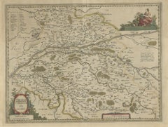
Antique Map of the Region of Franche-Comté by Janssonius, circa 1650
Located in Langweer, NL
Antique map titled 'Burgundiae Comitatus Franche Comté'. Old map of the historical and former region of Franche-Comté, France. As a region, it encompasse...
Category
Antique Mid-17th Century Maps
Materials
Paper

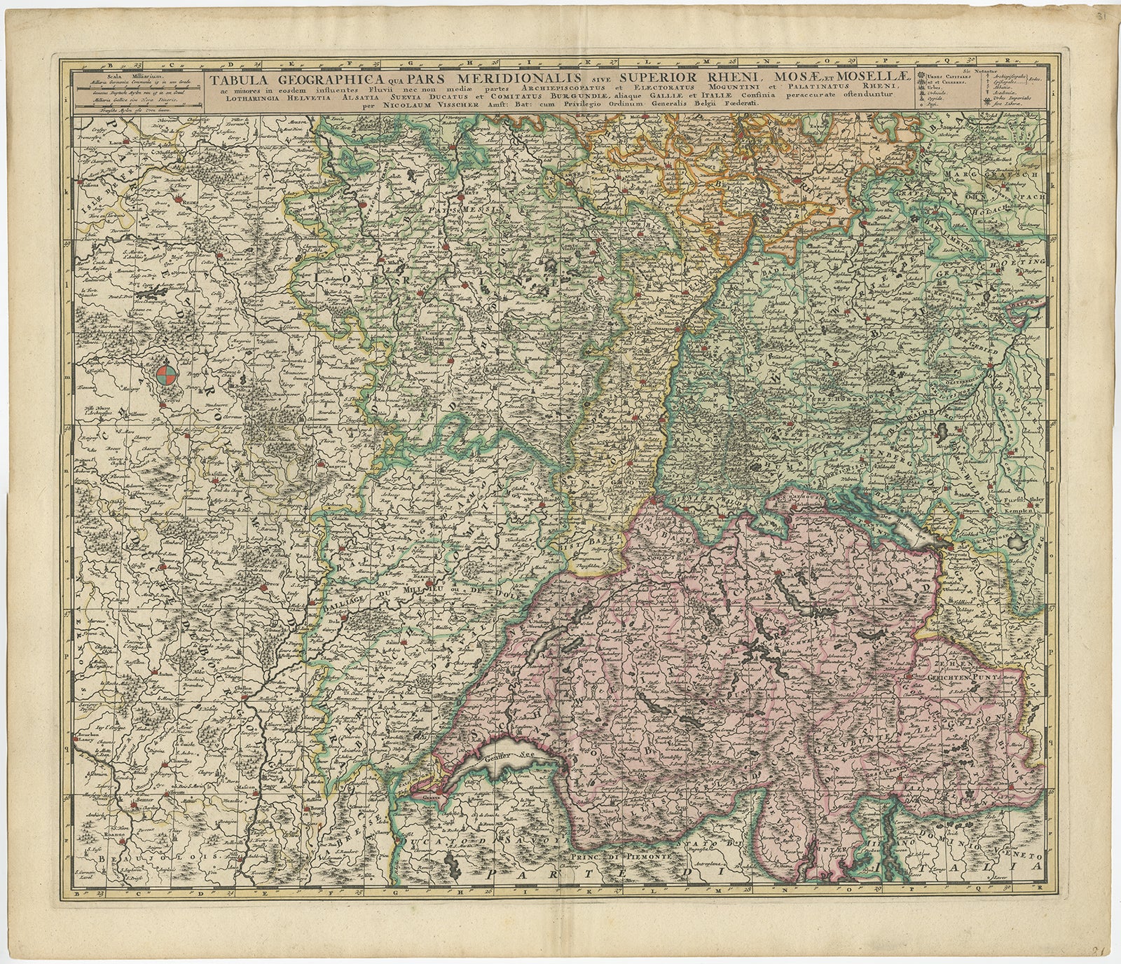
Antique Map of Switzerland by N. Visscher, circa 1690
Located in Langweer, NL
Antique map titled 'Tabula Geogaphica qua Pars Meridionalis sive Superior Rheni, Mosae, et Mosellae (..)'. Published by N. Visscher, Amsterdam, circa 1690. Contemporary coloring.
Category
Antique Late 17th Century Maps
Materials
Paper
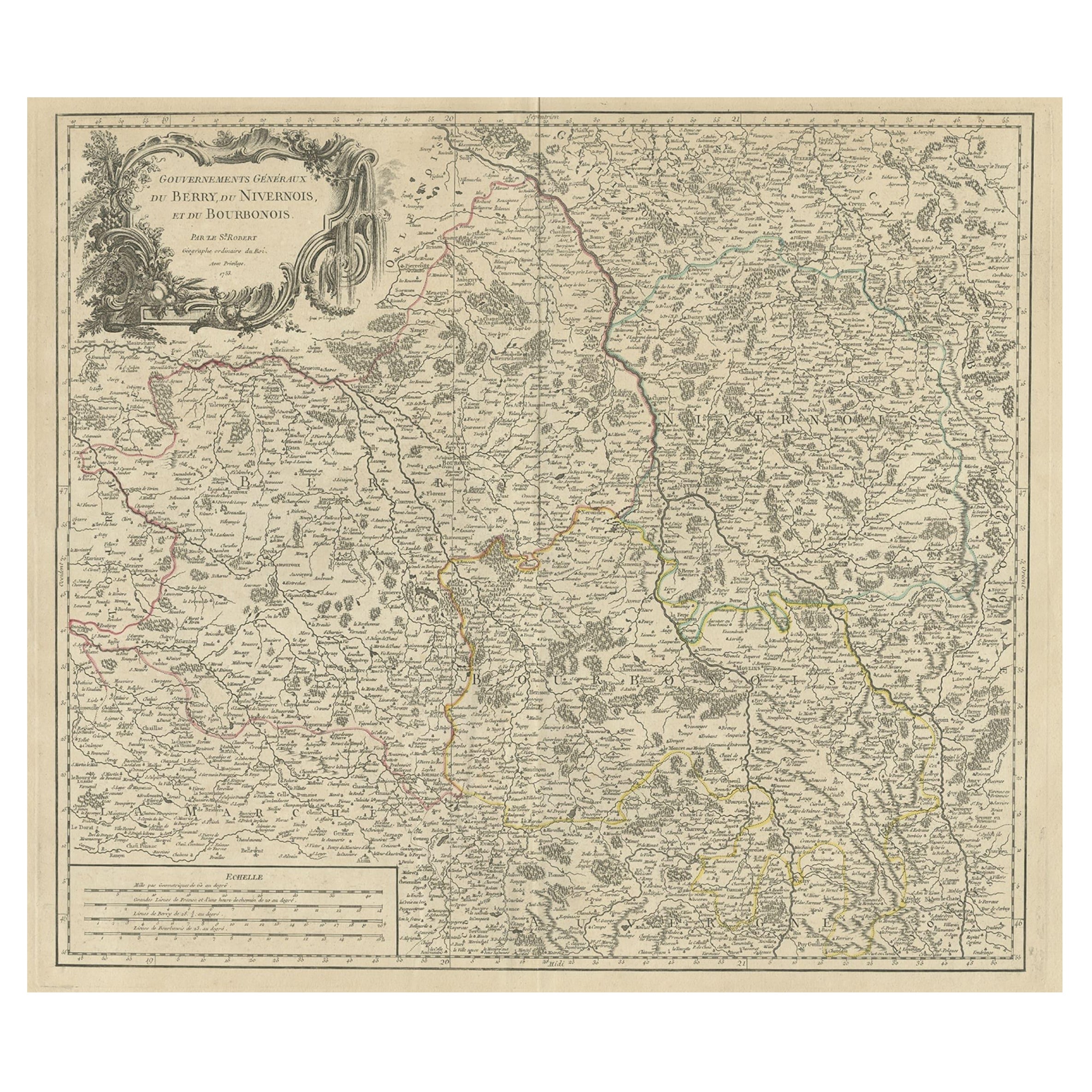
Large Antique Map of the Region of Berry, Nivernois
Bourbonnais, France, 1753
Located in Langweer, NL
Antique map titled 'Gouvernements généraux du Berry, du Nivernois et du Bourbonois'.
Large, original antique map of the region of Berry, Nivernois and Bourbonnais, France. Featur...
Category
Antique 1750s Maps
Materials
Paper
Antique Map of the Namur Region
France
by F. de Wit, circa 1680
Located in Langweer, NL
Antique map titled 'Comitatus Namurci Tabula in Lucem Edita'. Large map of the Namur region, France. Published by F. de Wit, circa 1680.
Category
Antique Late 17th Century Maps
Materials
Paper

$552 Sale Price
20% Off
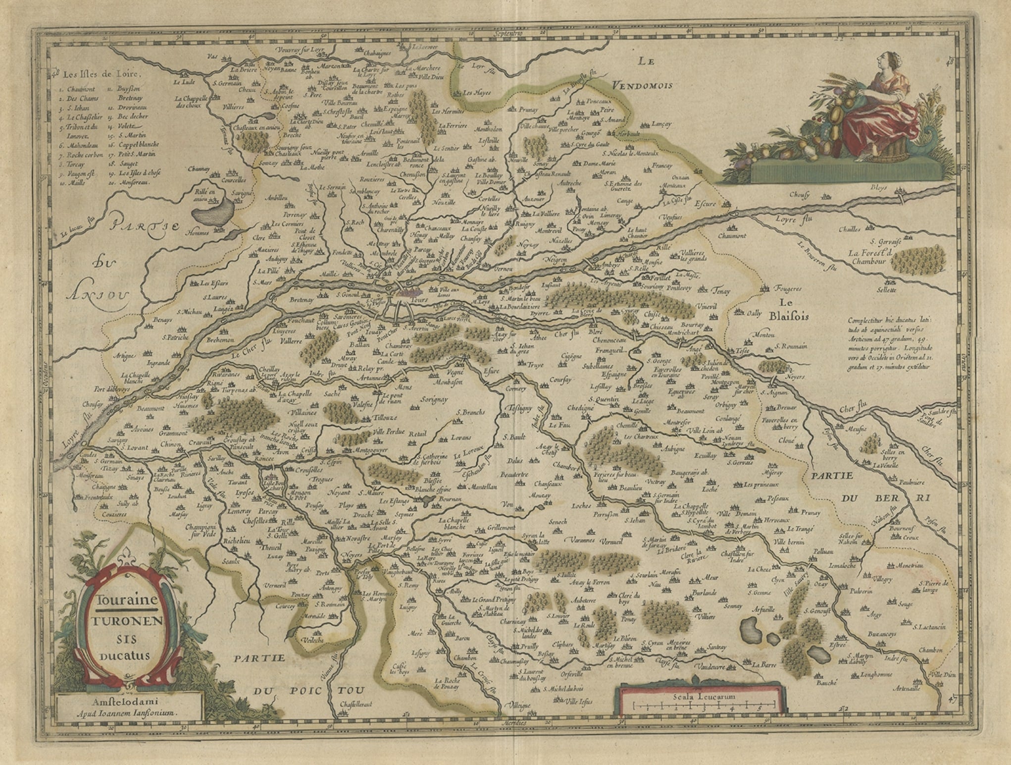
Antique Map of the Region of Touraine in France by Janssonius, 1657
By Johannes Janssonius
Located in Langweer, NL
Antique map titled 'Touraine - Turonensis Ducatus'.
Decorative map of the Touraine region. This map originates from 'Atlas Novus, Sive Theatrum Orbis Orbis Terrarum: In quo Galli...
Category
Antique 17th Century Maps
Materials
Paper
You May Also Like
1771 Bonne Map of Poitou, Touraine and Anjou, France, Ric.a015
Located in Norton, MA
1771 Bonne Map of Poitou,
Touraine and Anjou, France
Ric.a015
1771 Bonne map of Potiou, Touraine and Anjou entitled "Carte des Gouvernements D'Anjou et du Saumurois, de la Touraine, du Poitou,du Pays d'aunis, Saintonge?Angoumois,"
Carte des gouvernements d'Anjou et du Saumurois, de la Touraine, du Poitou, du Pays d'Aunis, Saintonge-Angoumois. Projettee et assujettie au ciel par M. Bonne, Hyd. du Roi. A Paris, Chez Lattre, rue St. Jacques a la Ville de Bord(ea)ux. Avec priv. du Roi. 1771. Arrivet inv. & sculp., Atlas moderne ou collection de cartes sur toutes...
Category
Antique 17th Century Unknown Maps
Materials
Paper

1640 Joan Bleau Map Entitled"Diocecese de rheims et le pais de rethel, " Eic.a011
Located in Norton, MA
1640 Joan Bleau map entitled
"Diocecese de rheims et le pais de rethel,"
Ric.a011
OAN BLAEU
Diocecese de Rheims, et le pais de Rethel.
Handcolored engraving, c.1640.
...
Category
Antique 17th Century Dutch Maps
Materials
Paper

1752 Vaugoundy Map of Flanders : Belgium, France, and the Netherlands, Ric.a002
Located in Norton, MA
Large Vaugoundy Map of Flanders:
Belgium, France, and the Netherlands
Colored -1752
Ric.a002
Description: This is a 1752 Didier Robert de Vaugondy map of Flanders. The map de...
Category
Antique 17th Century Unknown Maps
Materials
Paper

1657 Janssonius Map of Vermandois and Cappelle, Ric. A-004
Located in Norton, MA
1657 Janssonius map of
Vermandois and Cappelle
Ric.a004
Description: Antique map of France titled 'Descriptio Veromanduorum - Gouvernement de la Cappelle'. Two detailed maps o...
Category
Antique 17th Century Unknown Maps
Materials
Paper

17th Century Hand Colored Map of the Liege Region in Belgium by Visscher
By Nicolaes Visscher II
Located in Alamo, CA
An original 17th century map entitled "Leodiensis Episcopatus in omnes Subjacentes Provincias distincté divisusVisscher, Leodiensis Episcopatus" by Nicolaes Visscher II, published in Amsterdam in 1688. The map is centered on Liege, Belgium, includes the area between Antwerp, Turnhout, Roermond, Cologne, Trier and Dinant.
This attractive map is presented in a cream-colored mat measuring 30" wide x 27.5" high. There is a central fold, as issued. There is minimal spotting in the upper margin and a tiny spot in the right lower margin, which are under the mat. The map is otherwise in excellent condition.
The Visscher family were one of the great cartographic families of the 17th century. Begun by Claes Jansz Visscher...
Category
Antique Late 17th Century Dutch Maps
Materials
Paper

$940 Sale Price
20% Off
1656 Jansson Map Metz Region of France Entitled "Territorium Metense" Ric0014
Located in Norton, MA
1656 Jansson map Metz Region of France entitled "Territorium Metense."
Ric0014
" Authentic" - Map of the historical region surrounding Metz, in Lorraine, France.
Oriented with ...
Category
Antique 17th Century Dutch Maps
Materials
Paper

More Ways To Browse
Pair Of Danish Chairs
Veneer Dining Tables
1970 Italian Armchair
Furniture Uk
House Of Denmark Table And Chairs
Louis Marble Top Side Table
Antique Russian Rugs
Baker Furniture By
For Kids
Sterling Silver Flatware Set Service For 12
Tufted Bar
Pair Of French Antique Armchairs
1970s Brass Glass Coffee Table
Antique Column Base
Charles Rennie Mackintosh For Cassina
Glass Salt
Italian Modern Silver Vases
Vintage Resin Tables