Items Similar to Large Antique Map of Texas with Panhandle
Bay Inset Maps, Colton, 1873
Want more images or videos?
Request additional images or videos from the seller
1 of 11
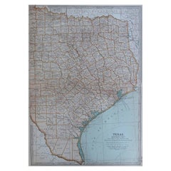
Large Antique Map of Texas with Panhandle
Bay Inset Maps, Colton, 1873
$877.39
£649.91
€730
CA$1,200.24
A$1,308.19
CHF 691.63
MX$15,748.19
NOK 8,778.52
SEK 8,048.11
DKK 5,562.20
About the Item
Large Antique Map of Texas with Panhandle
Bay Inset Maps, Colton, 1873
This richly detailed and visually striking antique map of Texas was published in 1873 by G.W.
C.B. Colton, one of the most prolific American cartographic publishing firms of the 19th century. Titled "Colton’s Texas", this is a later edition of Colton's double-page state map, showing the rapidly developing infrastructure and administrative divisions in Texas during the post-Civil War expansion era.
The map presents a comprehensive overview of the state, with the eastern and central regions densely subdivided into counties, while the western region still contains large, unsettled tracts such as Presidio, El Paso, and Pecos. Notably, the previously vast Bexar and Young territories have been broken up into numerous new counties, reflecting a political and demographic reorganization that dates the map close to 1876, despite the printed date of 1873.
Railroad lines are shown in detail, revealing Texas’ emerging transport network, along with extensive labeling of forts, post offices, roads, rivers, springs, and topographical features. The cartographic style is clear and meticulous, employing soft hand coloring to delineate counties.
The map includes four informative inset maps:
* A large "Plan of the Northern Part or Panhandle of Texas"
* "Plan of Galveston Bay from the U.S. Coast Survey"
* "Plan of Matagorda Bay"
* "Plan of Sabine Lake"
These insets provide enhanced regional detail of Texas’ critical coastal and frontier areas. The map is further embellished with Colton’s iconic decorative scrollwork border and bold titling.
This map is not only a valuable historical artifact but also a beautiful example of American cartography, ideal for collectors interested in Texan history, westward expansion, or 19th-century U.S. development.
Condition Report:
Original hand color. Light toning along edges with a few minor chips at top and bottom. A couple of short edge tears have been archivally repaired. Trimmed close to the lower border by the binder but not affecting image or title. Centerfold as issued.
Framing Tips:
A walnut or dark oak frame works well to highlight the earth-tone palette of the map. Pair with a deep cream or antique white mat, ideally with a gilt inner fillet to echo the scroll border design. Oversized UV glass is recommended for protection and visual clarity.
Technique: Lithograph with original hand coloring
Maker: G.W.
C.B. Colton, New York, 1873 (dated)
- Dimensions:Height: 17.52 in (44.5 cm)Width: 27.6 in (70.1 cm)Depth: 0.01 in (0.2 mm)
- Materials and Techniques:Paper,Engraved
- Period:
- Date of Manufacture:1873
- Condition:Original hand color. Light toning along edges with a few minor chips at top and bottom. A couple of short edge tears have been archivally repaired. Trimmed close to the lower border by the binder but not affecting image or title. Centerfold as issued.
- Seller Location:Langweer, NL
- Reference Number:Seller: BG-141121stDibs: LU3054346013222
About the Seller
5.0
Recognized Seller
These prestigious sellers are industry leaders and represent the highest echelon for item quality and design.
Platinum Seller
Premium sellers with a 4.7+ rating and 24-hour response times
Established in 2009
1stDibs seller since 2017
2,813 sales on 1stDibs
Typical response time: 1 hour
- ShippingRetrieving quote...Shipping from: Langweer, Netherlands
- Return Policy
More From This Seller
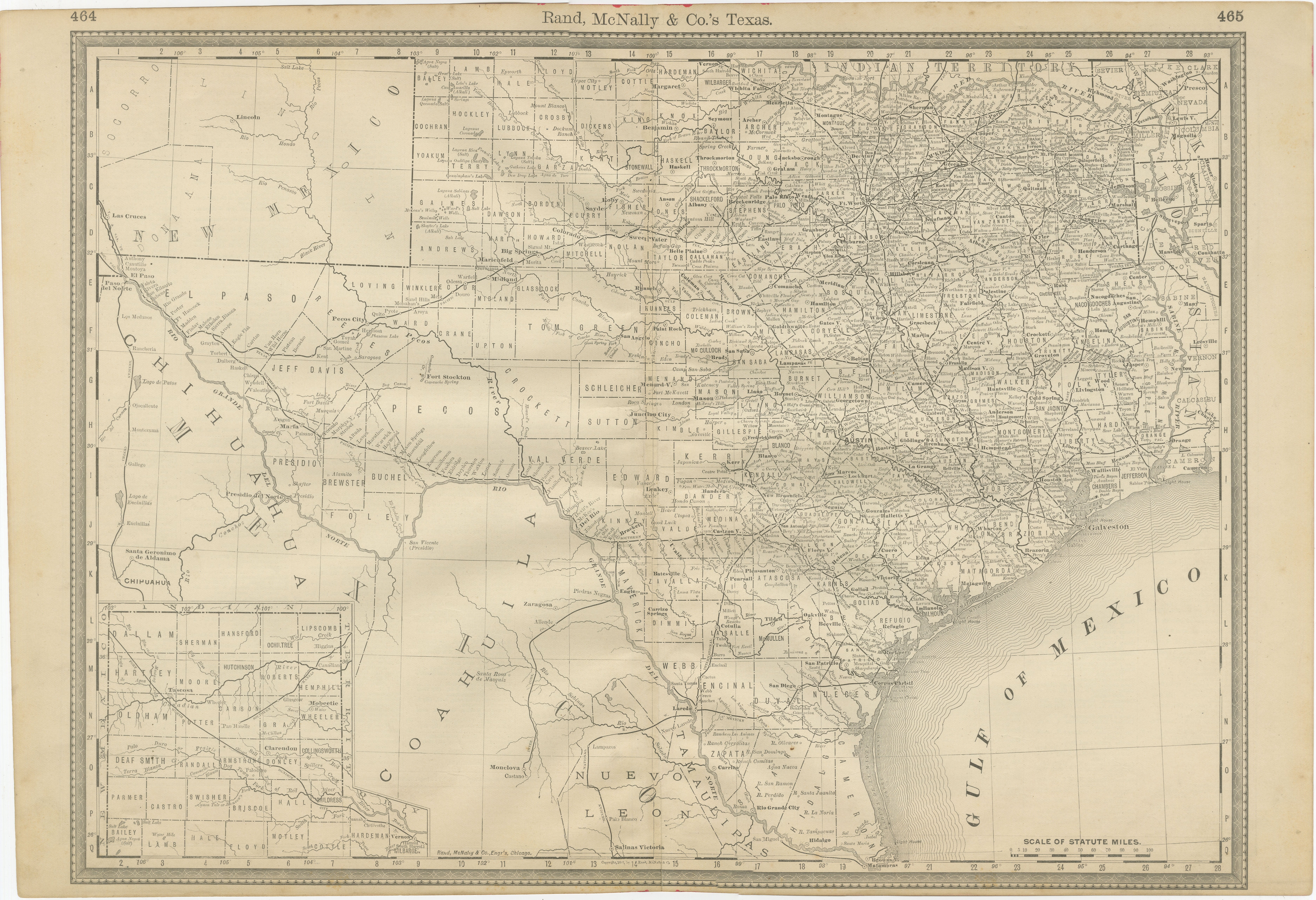
View AllTexas Antique Map 1888 – Railroads, Counties
Frontier Settlements
Located in Langweer, NL
Texas Railroad Map 1888 – Rand McNally Antique Lithograph
This antique 1888 map of Texas, published by Rand, McNally & Co., provides a detailed overview of the state during a critic...
Category
Antique Late 19th Century American Maps
Materials
Paper

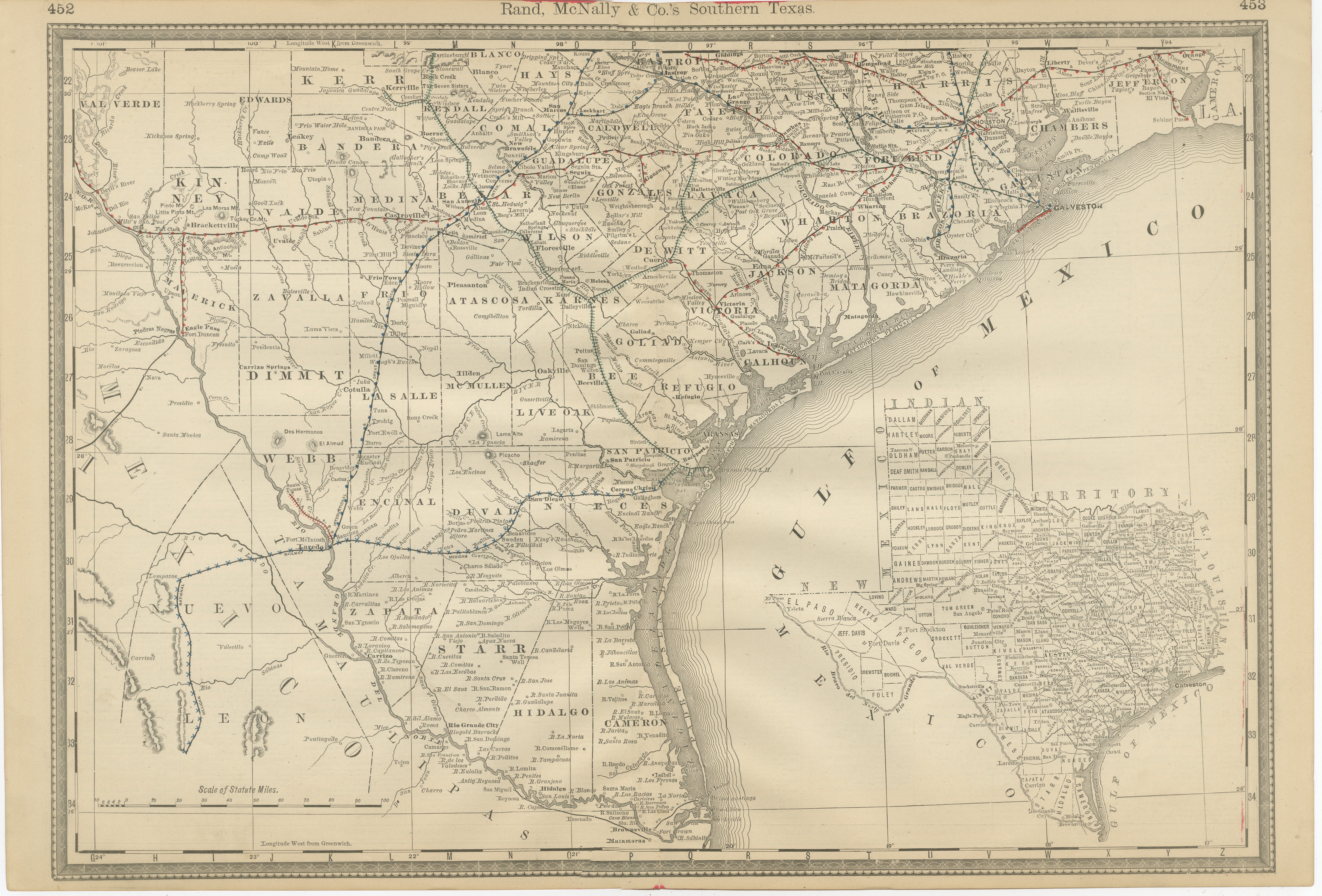
Antique Map 1888 – Southern Texas Railroads, Counties
Settlements
Located in Langweer, NL
Southern Texas Map 1888 – Rand McNally Antique Lithograph
This antique 1888 map of Southern Texas, published by Rand, McNally & Co., depicts the Gulf Coast and borderlands with Mexi...
Category
Antique Late 19th Century American Maps
Materials
Paper
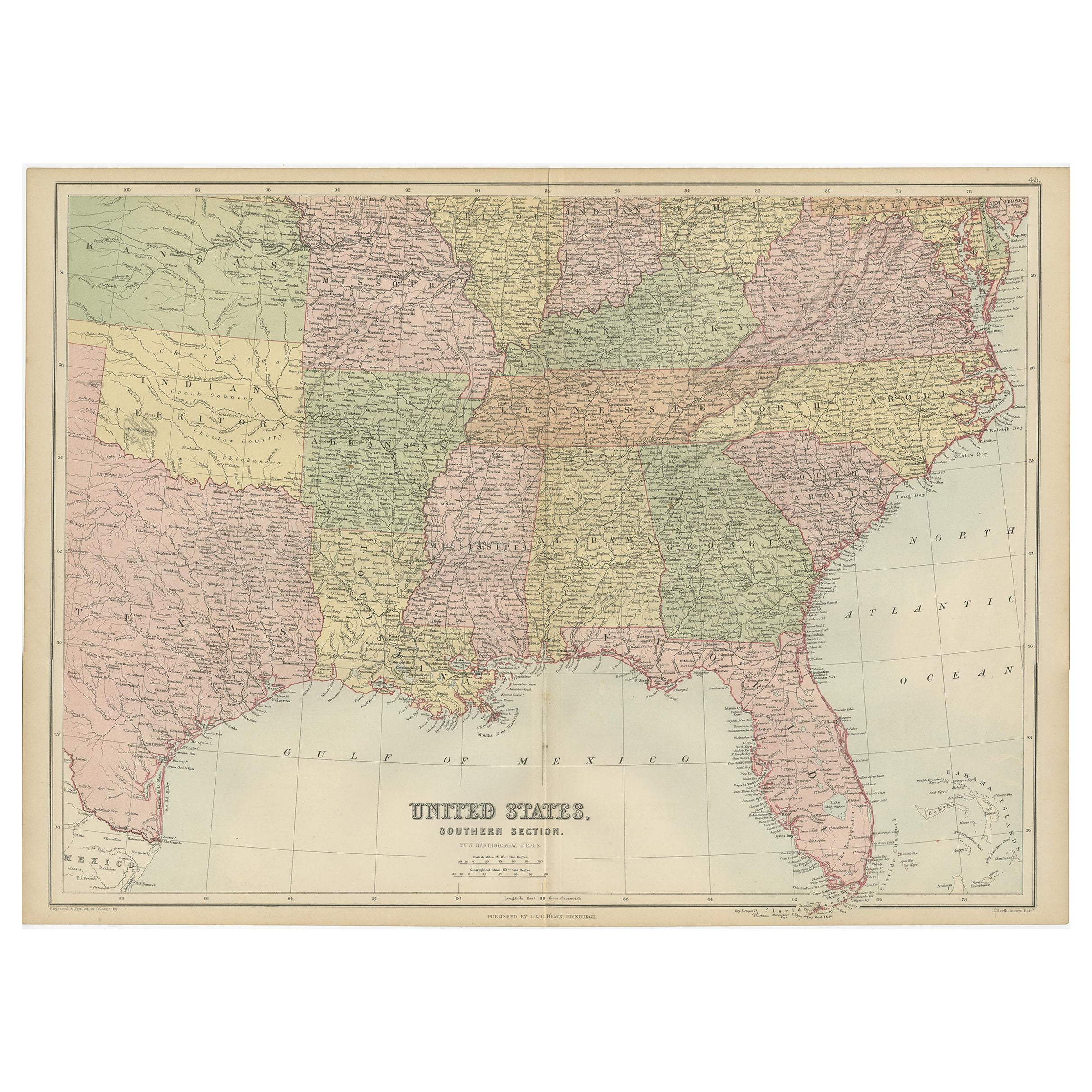
Antique Map of The United States Southern Section by A
C. Black, 1870
Located in Langweer, NL
Antique map titled 'United States Southern Section'. Original antique map of Map of The United States Southern Section. This map originates from ‘Black's General Atlas of The World’....
Category
Antique Late 19th Century Maps
Materials
Paper

$240 Sale Price
20% Off
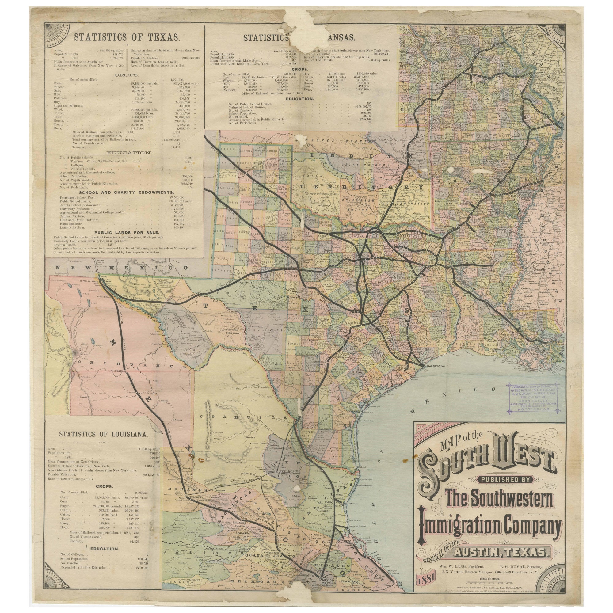
Southwestern U.S. Immigration Map for Texas, Arkansas, and Louisiana, 1881
Located in Langweer, NL
Southwestern U.S. Immigration Map - Published by The Southwestern Immigration Company, Austin, Texas. Detailed Railroad Routes and Regional Statistics for Texas, Arkansas, and Louisi...
Category
Antique 1880s Maps
Materials
Paper
$991 Sale Price
25% Off
Free Shipping
Antique Map of the United States by Titus
1871
Located in Langweer, NL
Antique map titled 'The United States of America'. Original antique map of the United States. This map originates from 'Atlas of Prebl...
Category
Antique Late 19th Century Maps
Materials
Paper

$769 Sale Price
20% Off
Antique Map of the Eastern United States with Inset Map of Texas
Located in Langweer, NL
Antique map titled 'Verein-Staaten von Nord-America mit Ausnahme Florida's und der Westlichen Territorien'. This map extends as far west as Louisiana and only includes the northern p...
Category
Antique Mid-19th Century Maps
Materials
Paper

$519 Sale Price
20% Off
You May Also Like
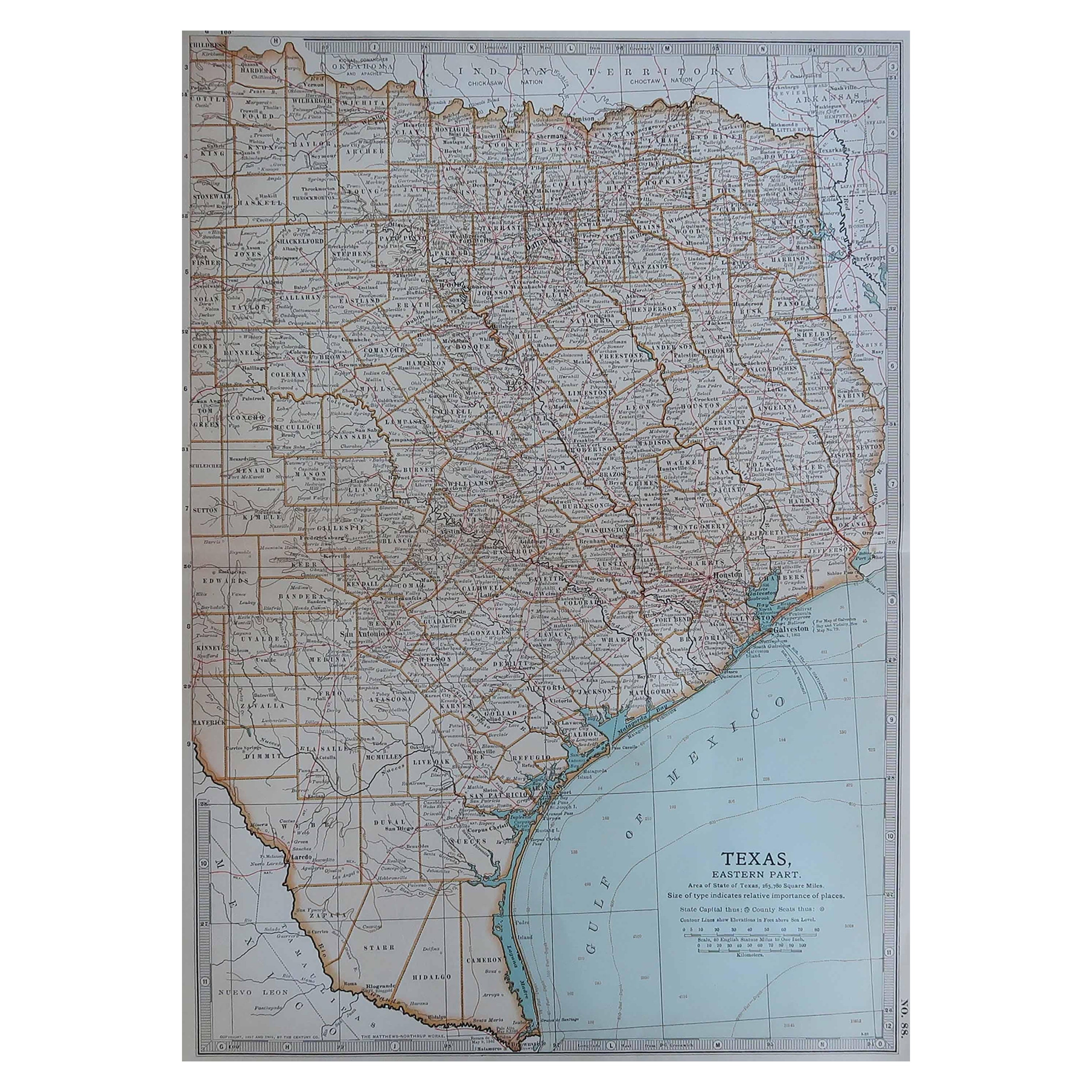
Original Antique Map of the American State of Texas ( Eastern Part ), 1903
Located in St Annes, Lancashire
Antique map of Texas ( Eastern part )
Published By A & C Black. 1903
Original colour
Good condition
Unframed.
Free shipping
Category
Antique Early 1900s English Maps
Materials
Paper
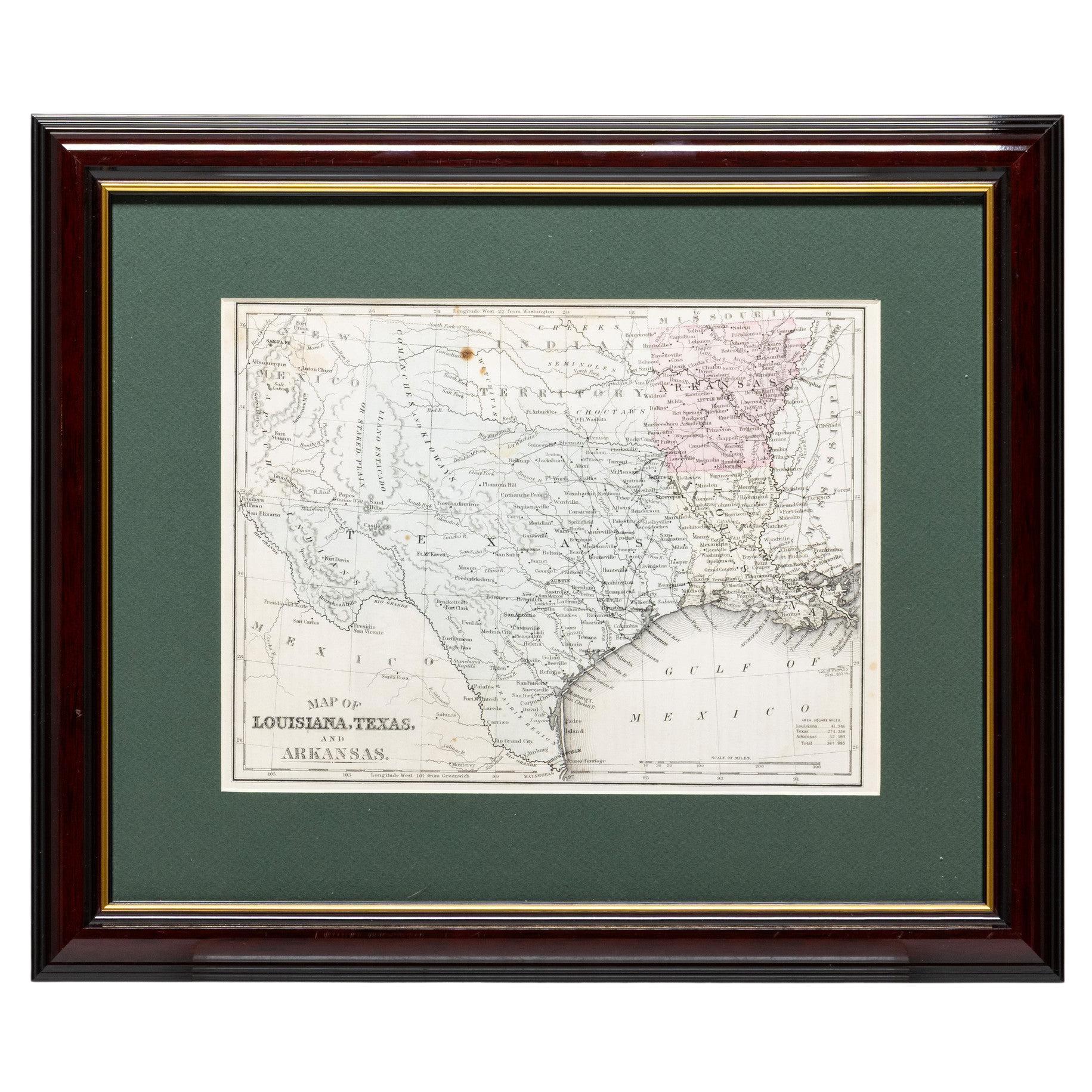
Framed Map of Texas Circa 1880
Located in Coeur d
Alene, ID
Framed circa 1880 map of Texas with Louisiana and Arkansas. Well detailed. Great for display in any home. Encased in cherry and gold frame with dark green mating. Size: 11" x 9", fra...
Category
Antique Late 19th Century American Maps
Materials
Paper
Framed Map of Texas Circa 1886
Located in Coeur d
Alene, ID
Framed circa 1886 map of Texas including Louisiana, Texas and Arkansas, with Indian territory. Well detailed. Great for display in any home. Encased in cherry and gold frame with dar...
Category
Antique Late 19th Century American Maps
Materials
Paper
Framed Map of Texas Circa 1908
Located in Coeur d
Alene, ID
Framed circa 1908 map of Texas. Each county separated and colored with panhandle of Texas on same scale in left corner. Well detailed. Would display nicely in any home. Encased in ch...
Category
Early 20th Century American Maps
Materials
Paper
1847 Antique Map of Mexico, Texas and California by Samuel Augustus Mitchell
By Samuel Augustus Mitchell 1
Located in Colorado Springs, CO
Presented is the second edition of Samuel Augustus Mitchell's Map of Mexico, Including Yucatan & Upper California, an important map showing the progress of the Mexican-American War. ...
Category
Antique 1840s American Maps
Materials
Paper

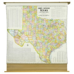
1850-1960 Cram
s Superior Latest Federal Census Texas Map
By G. F. Cram Company
Located in New York, NY
The 1850-1960 Cram's Superior Latest Federal Census Texas Map, crafted from pine wood, steel, and canvas, is a valuable historical cartographic piece. Publi...
Category
Vintage 1910s American Maps
Materials
Canvas
More Ways To Browse
Beni Ourain Rugs
Glass Top Wood Base Coffee Tables
T Chair
Pair Of Danish Chairs
Veneer Dining Tables
1970 Italian Armchair
Furniture Uk
House Of Denmark Table And Chairs
Louis Marble Top Side Table
Antique Russian Rugs
Baker Furniture By
For Kids
Sterling Silver Flatware Set Service For 12
Tufted Bar
Pair Of French Antique Armchairs
1970s Brass Glass Coffee Table
Antique Column Base
Charles Rennie Mackintosh For Cassina