Items Similar to Large Antique Set Ottoman Empire Maps – Europe
Asia in Striking Detail, 1868

Want more images or videos?
Request additional images or videos from the seller
1 of 12
Large Antique Set Ottoman Empire Maps – Europe
Asia in Striking Detail, 1868
$887.97per set
£658.04per set
€740per set
CA$1,213.59per set
A$1,321.09per set
CHF 701.24per set
MX$15,895.62per set
NOK 8,885.64per set
SEK 8,141.75per set
DKK 5,636.80per set
About the Item
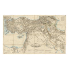
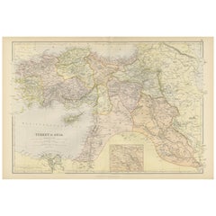
Antique Maps of the Ottoman Empire – Europe and Asia by Andriveau-Goujon, circa 1865
This finely engraved and hand-colored two-sheet map of the Ottoman Empire was published in Paris by E. Andriveau-Goujon in the 1860s. Titled simply “Empire Ottoman,” it presents the full territorial extent of the Ottoman domains across both Europe and Asia, divided across two joined plates from the Atlas Universel series: one sheet covering the European provinces (Empire Ottoman en Europe), and the other focused on the Asian provinces (Empire Ottoman en Asie).
The left sheet illustrates Ottoman Europe, including present-day Greece, Bulgaria, Albania, Macedonia, Serbia, Bosnia, and parts of Romania and Turkey-in-Europe. Major cities like Constantinople, Thessaloniki, Adrianople, and Belgrade are clearly marked, along with dense networks of roads, rivers, and mountain ranges. The Aegean islands and parts of the eastern Mediterranean, including Crete and Cyprus, are included in fine detail.
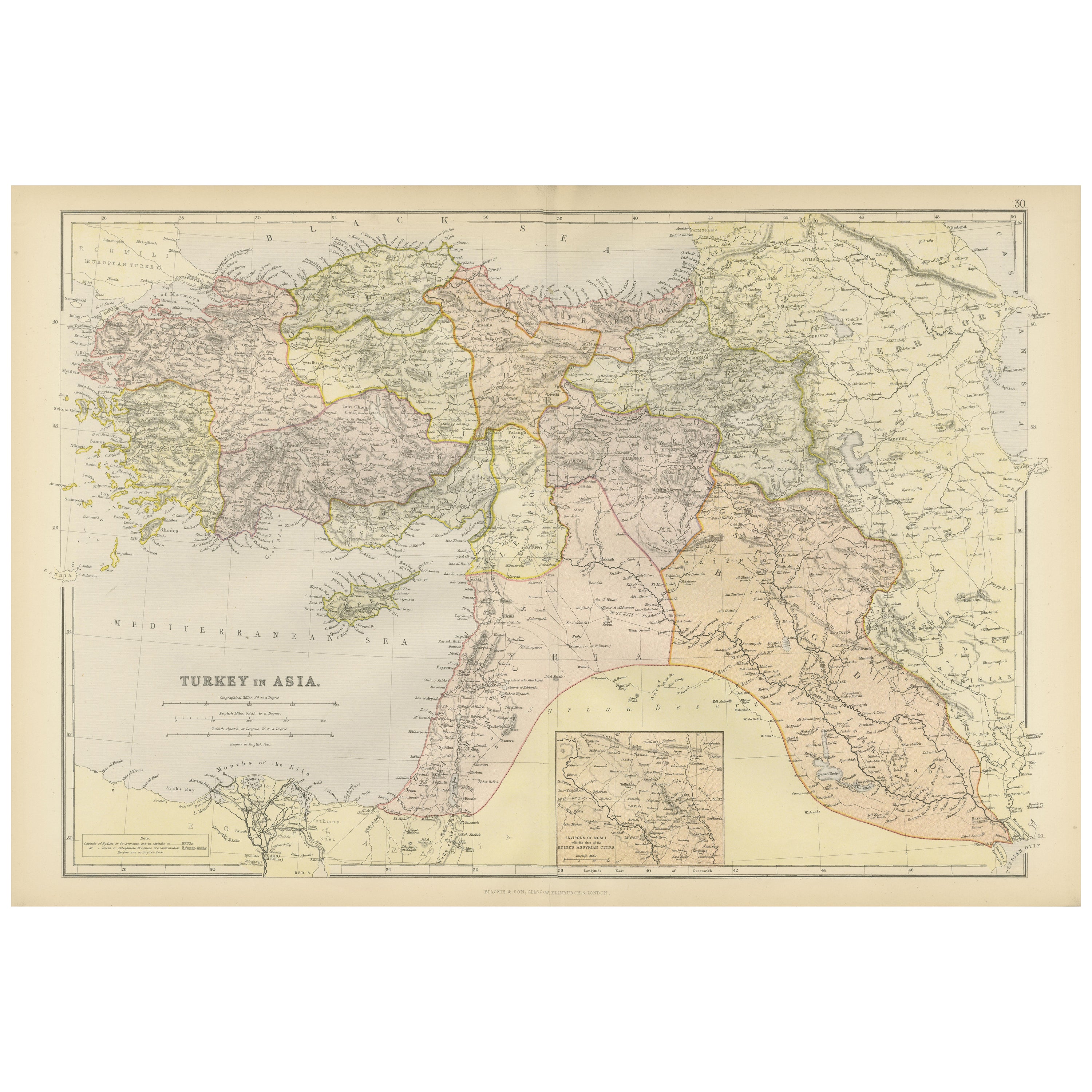
The right-hand sheet maps the Asian part of the empire, extending from Anatolia across the Levant, Mesopotamia, and into the fringes of Arabia and Persia. It includes regions corresponding to modern-day Turkey, Syria, Lebanon, Israel, Palestine, Iraq, and parts of Armenia and Georgia. Notable cities such as Aleppo, Damascus, Baghdad, Mosul, and Smyrna (Izmir) are all labeled. The map includes a boxed legend at the bottom showing administrative divisions of the empire, such as vilayets (provinces), sanjaks (districts), and key fortified cities.
Color coding separates administrative boundaries while retaining the pastel elegance typical of mid-19th century French cartography. These two sheets offer an unusually complete view of the Ottoman Empire’s reach during its final century of existence and provide valuable insight into the political geography of the Eastern Mediterranean before the sweeping changes of the late 19th and early 20th centuries.
Condition: Very good condition. Original centerfolds as issued. Slight age toning and minor marginal spotting. Clean impressions with strong original hand coloring. Plates numbered 32 and 33.
Framing tips: These two sheets may be displayed side by side or joined and framed as a single composition. Use a wide ivory mat and a dark wood or antique gold frame. A muted red or sage green inner mat can complement the Ottoman palette.
Technique: Engraving with original hand coloring
Maker: E. Andriveau-Goujon, Paris, circa 1860s
- Dimensions:Height: 27.64 in (70.2 cm)Width: 20.91 in (53.1 cm)Depth: 0.01 in (0.2 mm)
- Sold As:Set of 2
- Materials and Techniques:Paper,Engraved
- Place of Origin:
- Period:
- Date of Manufacture:1868
- Condition:Condition: Very good condition. Original centerfolds as issued. Slight age toning and minor marginal spotting. Clean impressions with strong original hand coloring. Plates numbered 32 and 33.
- Seller Location:Langweer, NL
- Reference Number:Seller: BG-14099-11, -121stDibs: LU3054346185892
About the Seller
5.0
Recognized Seller
These prestigious sellers are industry leaders and represent the highest echelon for item quality and design.
Platinum Seller
Premium sellers with a 4.7+ rating and 24-hour response times
Established in 2009
1stDibs seller since 2017
2,819 sales on 1stDibs
Typical response time: 1 hour
- ShippingRetrieving quote...Shipping from: Langweer, Netherlands
- Return Policy
More From This Seller
View AllOriginal Antique Map of the Middle East, Published in Germany, c.1870
Located in Langweer, NL
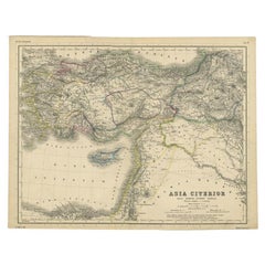
Antique map titled 'Asia Citerior'. Old map of the Middle East. This map originates from 'Atlas Antiquus, twaalf kaarten behoorende bij de Oude ...
Category
Antique 19th Century Maps
Materials
Paper
Mediterranean, Black Sea
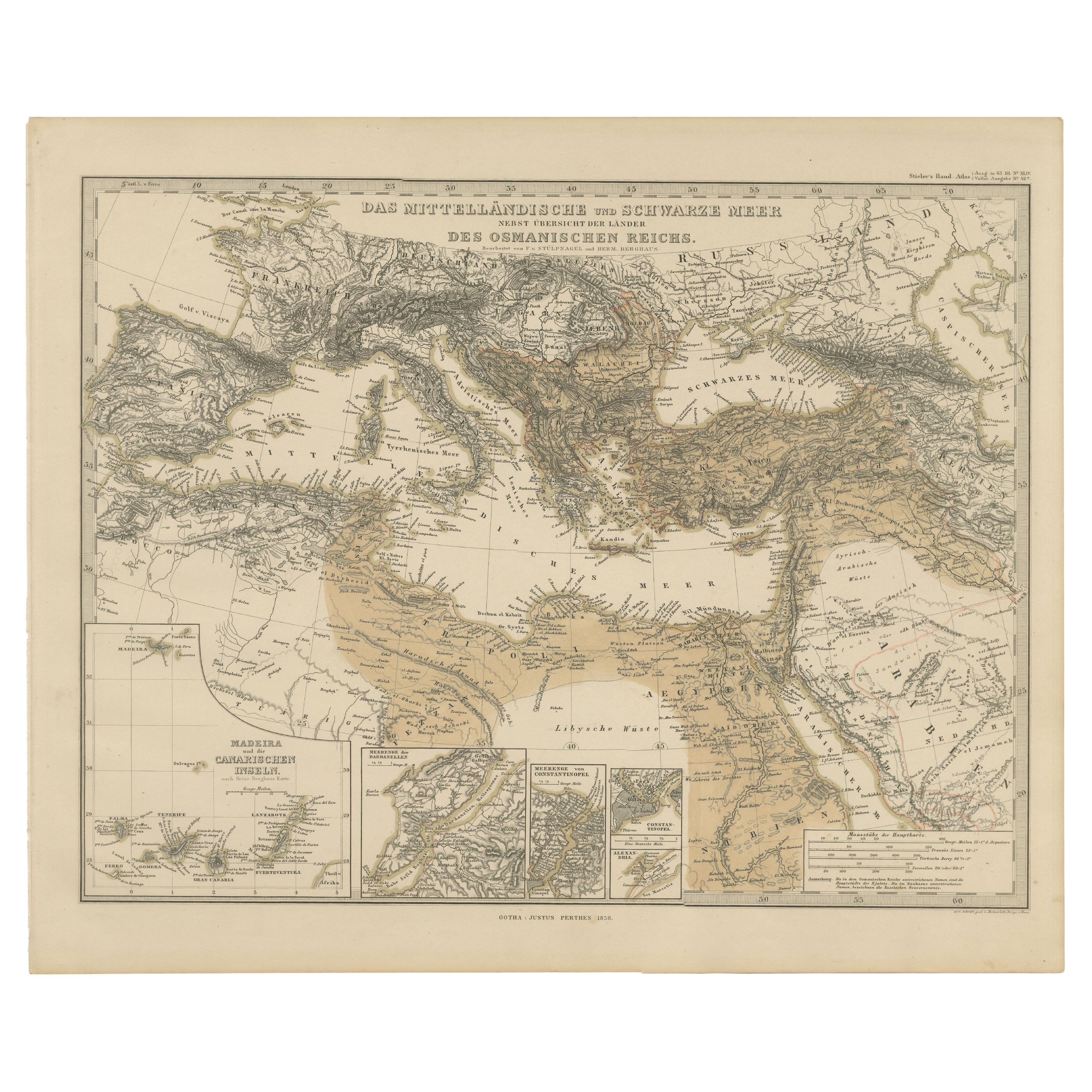
Ottoman Empire Map 1853
Located in Langweer, NL
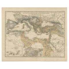
Mediterranean, Black Sea & Ottoman Empire Map 1853
This impressive antique print shows the Mediterranean and Black Sea regions with a focus on the Ottoman Empire, titled “Das Mittel...
Category
Antique Mid-19th Century German Maps
Materials
Paper
Balkans
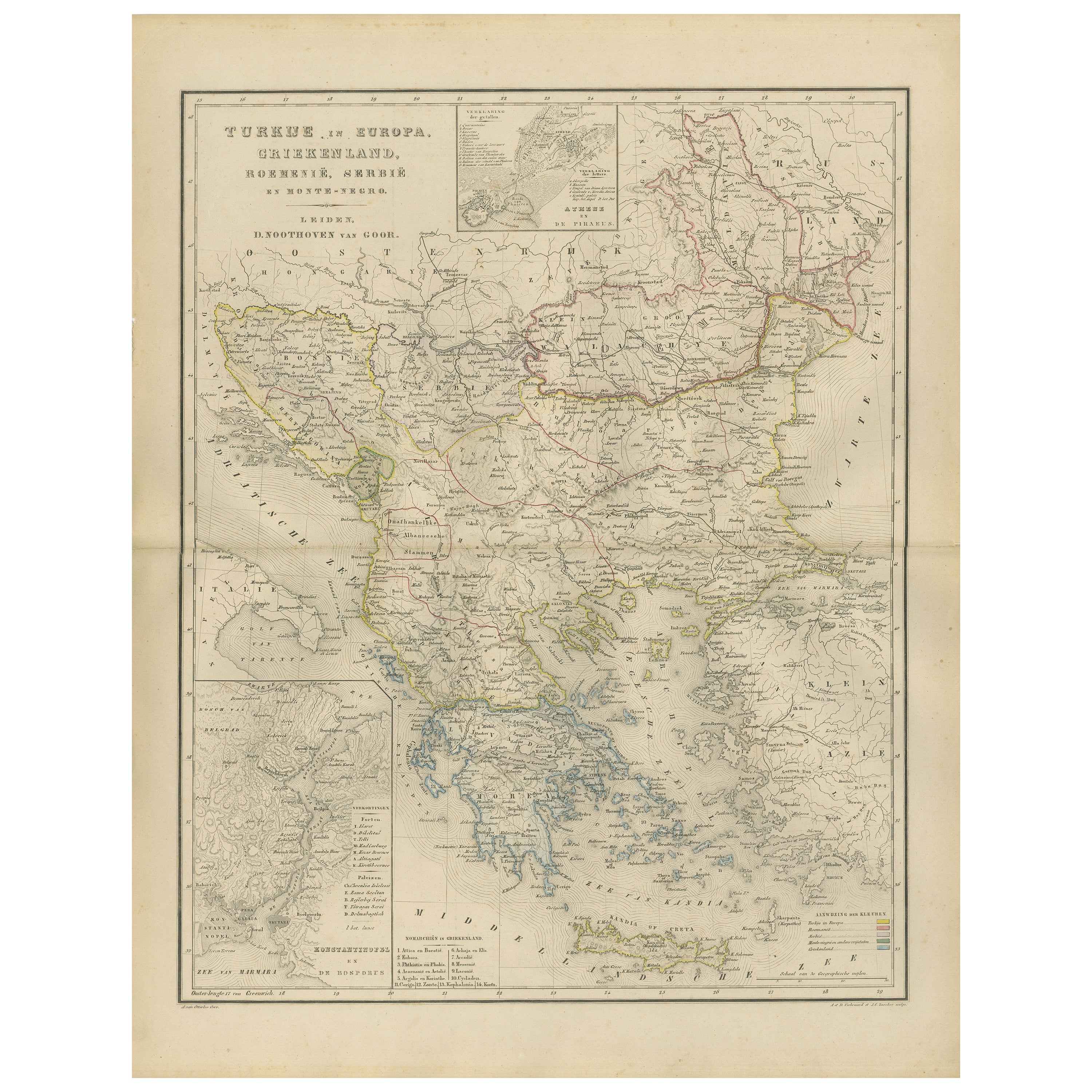
Ottoman Europe Map with Athens Inset – Nieuwe Hand-Atlas, 1876
Located in Langweer, NL
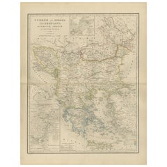
Balkans & Ottoman Europe Map with Athens Inset – Nieuwe Hand-Atlas, 1876
This impressive 19th-century map titled “Turkije in Europa, Griekenland, Roemenië, Servië en Montenegro” provides a richly detailed view of the Balkan Peninsula and the remaining European territories of the Ottoman Empire during a critical historical moment. Published in 1876 in the Nieuwe Hand-Atlas der Aarde in haren Tegenwoordigen Toestand by M. Frijlink, revised by A. van Otterloo and printed by D. Noothoven van Goor in Leiden, this map captures the political and geographical landscape of the Balkans just before the Russo-Turkish War (1877–78) and the subsequent Treaty of Berlin reshaped the region.
The map spans from the Adriatic Sea to the Black Sea, and from the Danube valley down to Crete, covering modern-day Greece, Albania, North Macedonia, Bulgaria, Romania, Serbia, Montenegro, Bosnia and Herzegovina, Thrace, European Turkey, and the Aegean Islands. Hand-colored boundary lines clearly distinguish political units including the Kingdom of Greece, the Principality of Serbia, the United Principalities of Wallachia and Moldavia (Romania), and Ottoman provinces such as Rumelia, Thessaly, Epirus, and Macedonia.
Major cities—Constantinople (Istanbul), Athens, Bucharest, Belgrade, Sofia, Salonika (Thessaloniki), Skodra, Ioannina, Larissa, Adrianople (Edirne), Varna, and Trabzon—are identified with fine engraving work. The map also reflects the complex geography of the region, showing mountain chains such as the Balkans, Pindus, Rhodope, and Dinaric Alps, as well as large river systems including the Danube, Morava, Drina, Vardar, Maritsa, and Iskar.
Inset maps provide valuable additional context: one illustrates the Bosphorus and surrounding fortifications, another focuses on Athens and Piraeus, and a third presents the region around the Gulf of Salonika and Northern Greece. These allow a closer look at strategic locations central to 19th-century European geopolitics.
This plate captures the Balkans at a moment of transition, when national movements were rising and the Ottoman Empire was gradually losing influence. The elegant engraving, refined typography, and harmonious composition are characteristic of Dutch educational cartography at its peak. Today, the map serves as a historical snapshot of a region defined by shifting borders, cultural layers, and emerging nation-states.
Condition Report:
Good condition with gentle toning and scattered small foxing marks, mostly in the margins. Original center fold as issued. Image clean and well-printed with soft, even hand-coloring. No tears, losses, or repairs.
Framing Tips: A light ivory or cream mat works beautifully to highlight the delicate color washes. A slim dark wood or black frame adds contrast and sophistication. Because the map includes attractive insets, a slightly wider mat border enhances balance and readability. Suitable for libraries, studies, travel-themed interiors, and collectors of Ottoman, Greek, and Balkan cartography.
Keywords: Balkans, Ottoman Empire, Turkey in Europe, European Turkey, Greece, Athens, Piraeus, Macedonia, Thrace, Epirus, Thessaly, Crete, Aegean Sea, Bulgaria, Sofia, Varna, Plovdiv, Romania, Bucharest, Wallachia, Moldavia, Danube, Serbia, Belgrade, Montenegro, Cetinje, Albania, Skodra, Ioannina, Thessaloniki, Salonika, Constantinople, Istanbul, Bosphorus, Dardanelles, Adriatic Sea, Aegean Islands, Balkan Peninsula, 19th century Balkans map, 1876 Ottoman map...
Category
Antique 1870s Dutch Maps
Materials
Paper
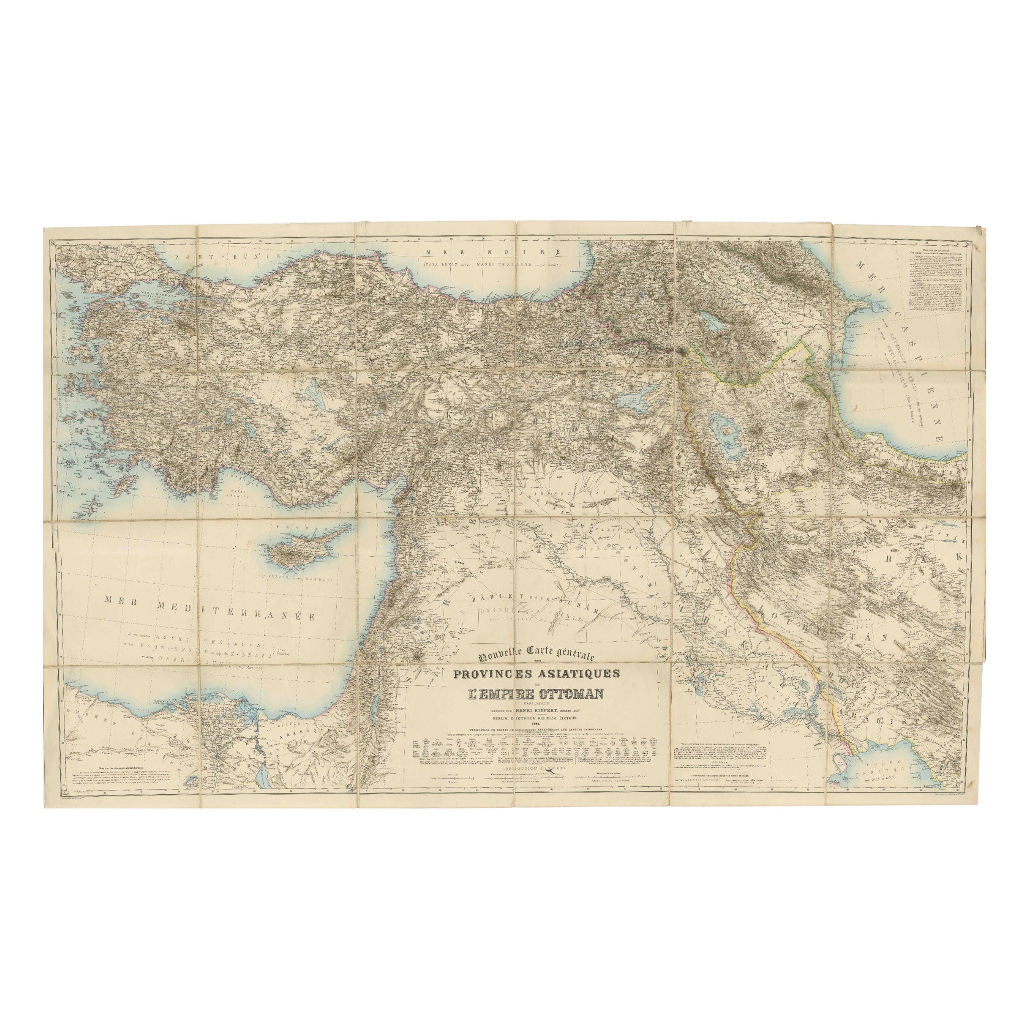
Large 1884 Kiepert Map of Asian Ottoman Provinces – Anatolia, Syria, Mesopotamia
Located in Langweer, NL
1884 Kiepert Map of Asian Ottoman Provinces – Anatolia, Syria, Mesopotamia
This remarkable mid-19th-century folding map is titled “Nouvelle Carte générale des Provinces Asiatiques d...
Category
Antique 1880s English Maps
Materials
Paper
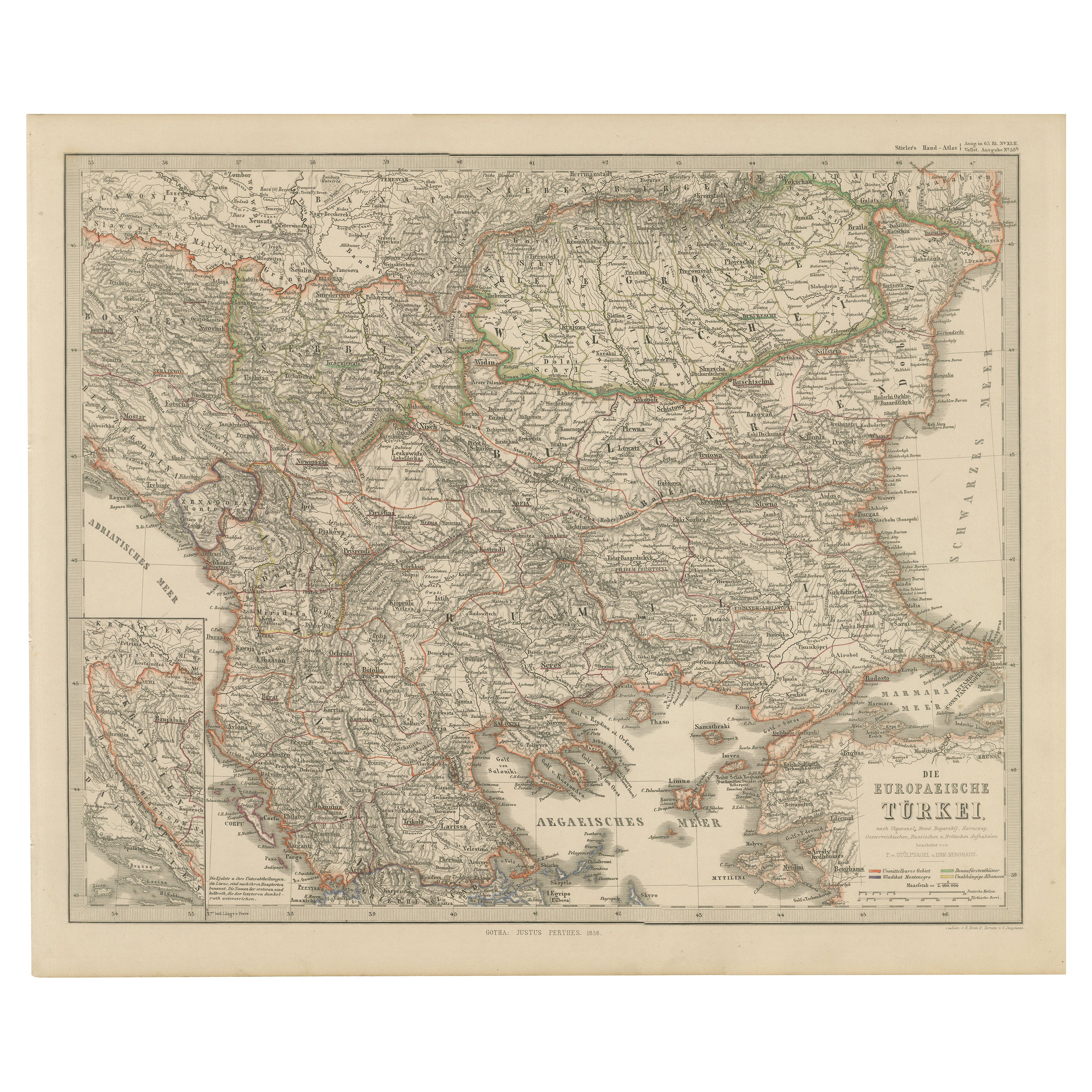
European Turkey Map – Detailed Balkan Ottoman Provinces 1858
Located in Langweer, NL
European Turkey and Greece Map – Balkans and Ionian Islands 1857
This detailed antique print shows “Die Europäische Türkei, Griechenland und die Ionische...
Category
Antique Mid-19th Century German Maps
Materials
Paper

Empire
s Crossroads: An 1882 Map of Turkey in Asia by Blackie
Son
Located in Langweer, NL
This map, titled "Turkey in Asia," is another detailed illustration from the 1882 atlas by Blackie & Son. It showcases the vastness of the Asian territories of the Ottoman Empire, sp...
Category
Antique 1880s Maps
Materials
Paper
$316 Sale Price
20% Off
You May Also Like
Large1852 Map "Russian Empire" Ric.r0011
Located in Norton, MA
Large
1852 map "Russian Empire"
George Phillips & Son 1852
Ric.r0011
Dimension: Paper: 67 cm W x 52 cm H ; Sight: 60cm W x 50 cm H
Condition: Good Condition with aged tonin...
Category
Antique 19th Century Unknown Maps
Materials
Paper

Map of Eastern Roman Empire -Vintage Offset Print - Early 20th Century
Located in Roma, IT
This map of Eastern Roman Empire is a vintage offset print realized in the early 20th Century.
The state of preservation of the artwork is aged with dif...
Category
Early 20th Century Figurative Prints
Materials
Offset

1870 "Johnson
s Europe" Map Published by A. J. Johnson
Located in Colorado Springs, CO
Presented is an original 1870 "Johnson’s Europe" map. First published in 1864, this map was issued as pages 87 and 88 in the 1870 edition of “Johnson's New Illustrated (Steel Plate) ...
Category
Antique 1870s American Victorian Maps
Materials
Paper

1860 Large Map "Carte De La Siberie Russie D
asie, " Ric.R0001
Located in Norton, MA
Large 1860 map "Carte De La Siberie Russie D'Asie," R-0001
" Authentic" - 1860 map "Carte De La Siberie Russie D'Asie,"
Dimension: Paper: 68 cm W x 51 cm H ; Sight: 51cm W x 4...
Category
Antique 19th Century Unknown Maps
Materials
Paper

Antique 1803 Italian Map of Asia Including China Indoneseia India
Located in Amsterdam, Noord Holland
Antique 1803 Italian Map of Asia Including China Indoneseia India
Very nice map of Asia. 1803.
Additional information:
Type: Map
Country of Manufacturing: Europe
Period: 19th centu...
Category
Antique 19th Century European Maps
Materials
Paper

$438 Sale Price
39% Off
Hand-Colored 18th Century Homann Map of the Black Sea, Turkey and Asia Minor
By Johann Baptist Homann
Located in Alamo, CA
An attractive original early 18th century hand-colored map of the Black Sea and Turkey entitled "Carte de L'Asie Minevre ou de la Natolie et du Pont Evxin Tiree des Voyages et des Ob...
Category
Antique Early 18th Century German Maps
Materials
Paper

$700 Sale Price
20% Off
More Ways To Browse
Antique Romanian
1868 Furniture
Palestine Antique
Antique Crete
Antique French Ottoman
Pair Of Danish Chairs
Veneer Dining Tables
1970 Italian Armchair
Furniture Uk
House Of Denmark Table And Chairs
Louis Marble Top Side Table
Antique Russian Rugs
Baker Furniture By
For Kids
Sterling Silver Flatware Set Service For 12
Tufted Bar
Pair Of French Antique Armchairs
1970s Brass Glass Coffee Table