Items Similar to Large Original Antique Map of Kansas, USA, 1894

Want more images or videos?
Request additional images or videos from the seller
1 of 5
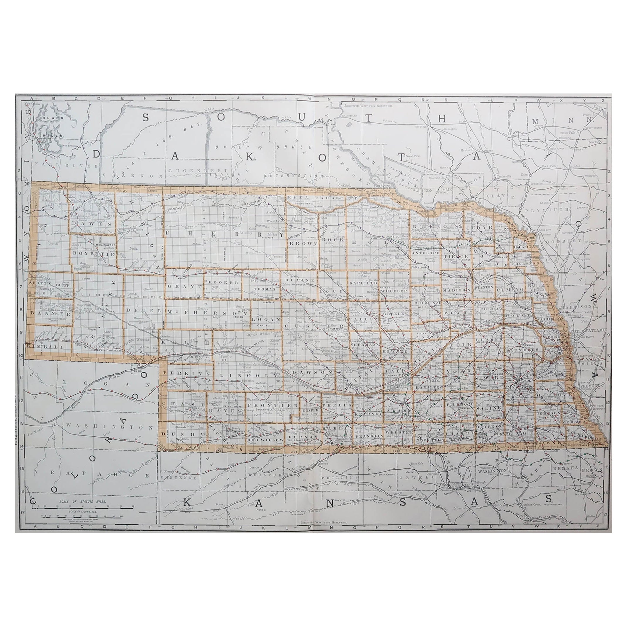
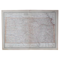
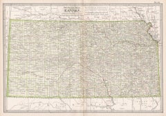
Large Original Antique Map of Kansas, USA, 1894
$90
£68.48
€78.90
CA$127.77
A$137.08
CHF 73.52
MX$1,650.38
NOK 926.87
SEK 845.18
DKK 589.48
About the Item
Fabulous map of Kansas
Original color
By Rand, McNally
Co.
Published, 1894
Unframed
Free shipping.
- Creator:Rand McNally Co. (Maker)
- Dimensions:Height: 20.5 in (52.07 cm)Width: 27 in (68.58 cm)Depth: 0.07 in (1.78 mm)
- Materials and Techniques:Paper,Other
- Place of Origin:
- Period:
- Date of Manufacture:1894
- Condition:Wear consistent with age and use.
- Seller Location:St Annes, GB
- Reference Number:1stDibs: LU1836334338402
About the Seller
4.9
Gold Seller
Premium sellers maintaining a 4.3+ rating and 24-hour response times
1stDibs seller since 2016
3,276 sales on 1stDibs
Typical response time: 1 hour
Associations
International Confederation of Art and Antique Dealers
Associations
- ShippingRetrieving quote...Shipping from: St Annes, United Kingdom
- Return Policy
More From This Seller
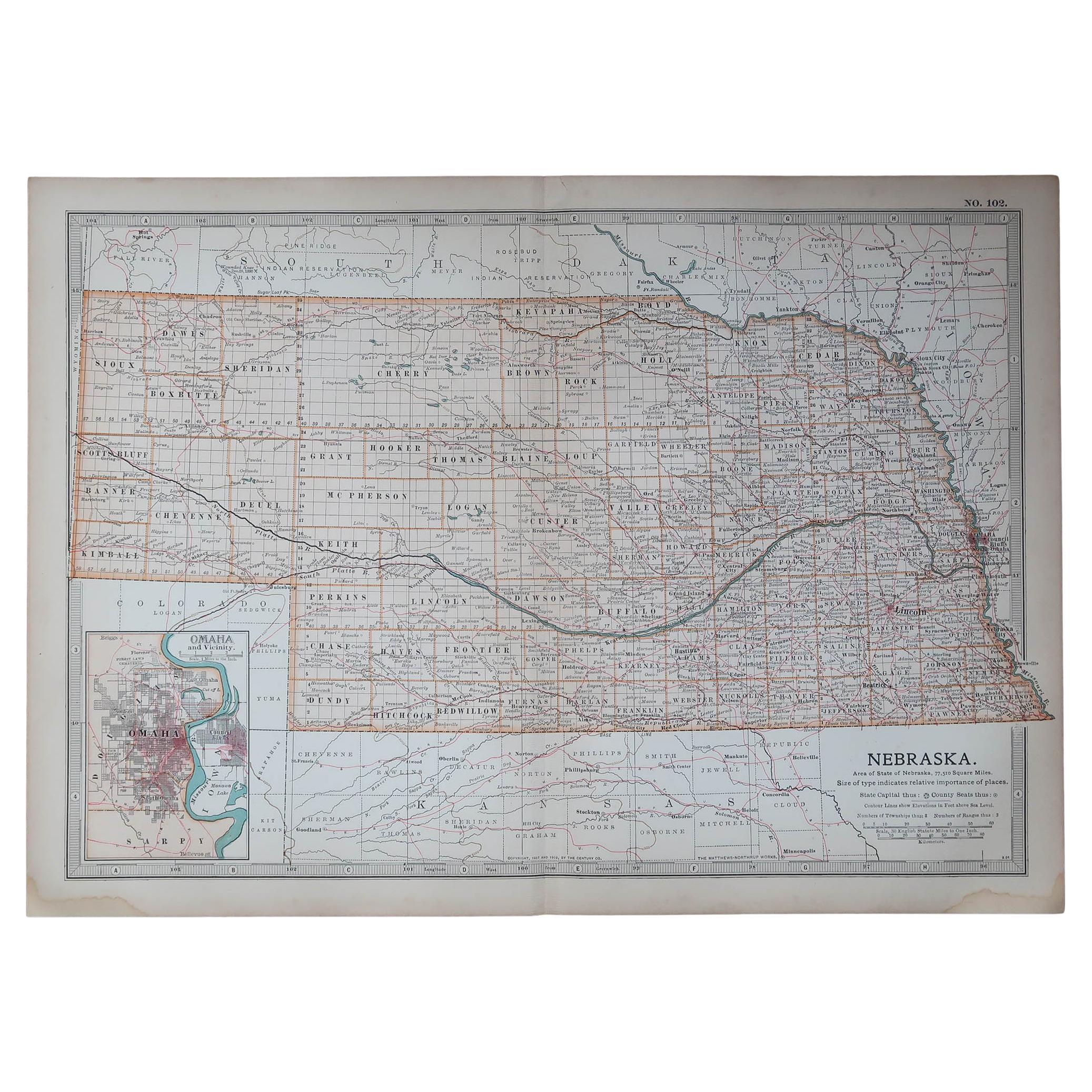
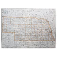
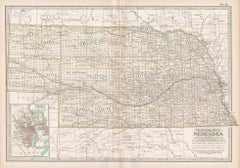
View AllLarge Original Antique Map of Nebraska, USA, 1894
By Rand McNally
Co.
Located in St Annes, Lancashire
Fabulous map of Nebraska
Original color
By Rand, McNally & Co.
Published, 1894
Unframed
Some slight restoration to the Gosper / Furnas area. Seen in the last image
Free shipping.
Category
Antique 1890s American Maps
Materials
Paper
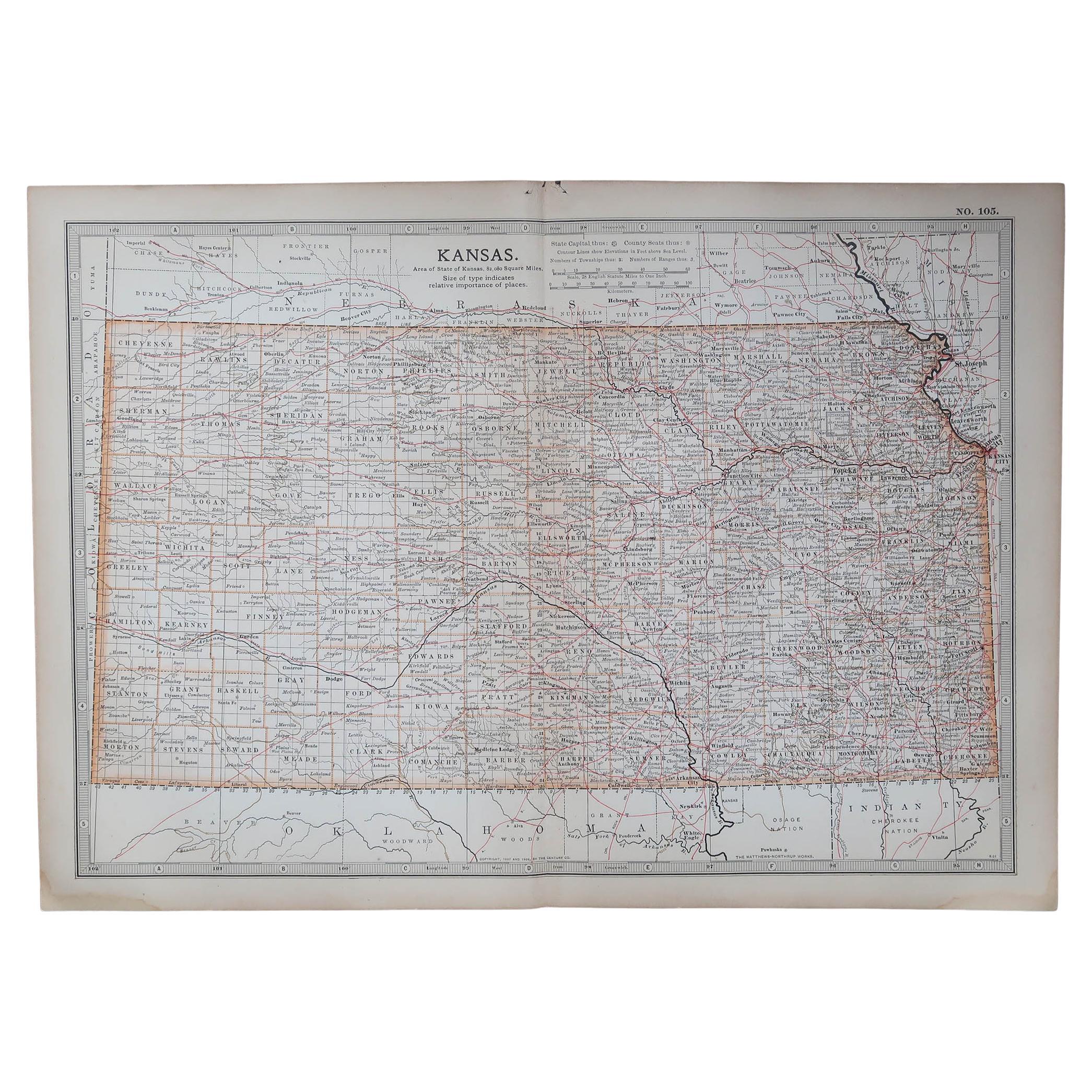
Original Antique Map of the American State of Kansas, 1903
Located in St Annes, Lancashire
Antique map of Kansas
Published By A & C Black. 1903
Original colour
Good condition
Unframed.
Free shipping
Category
Antique Early 1900s English Maps
Materials
Paper
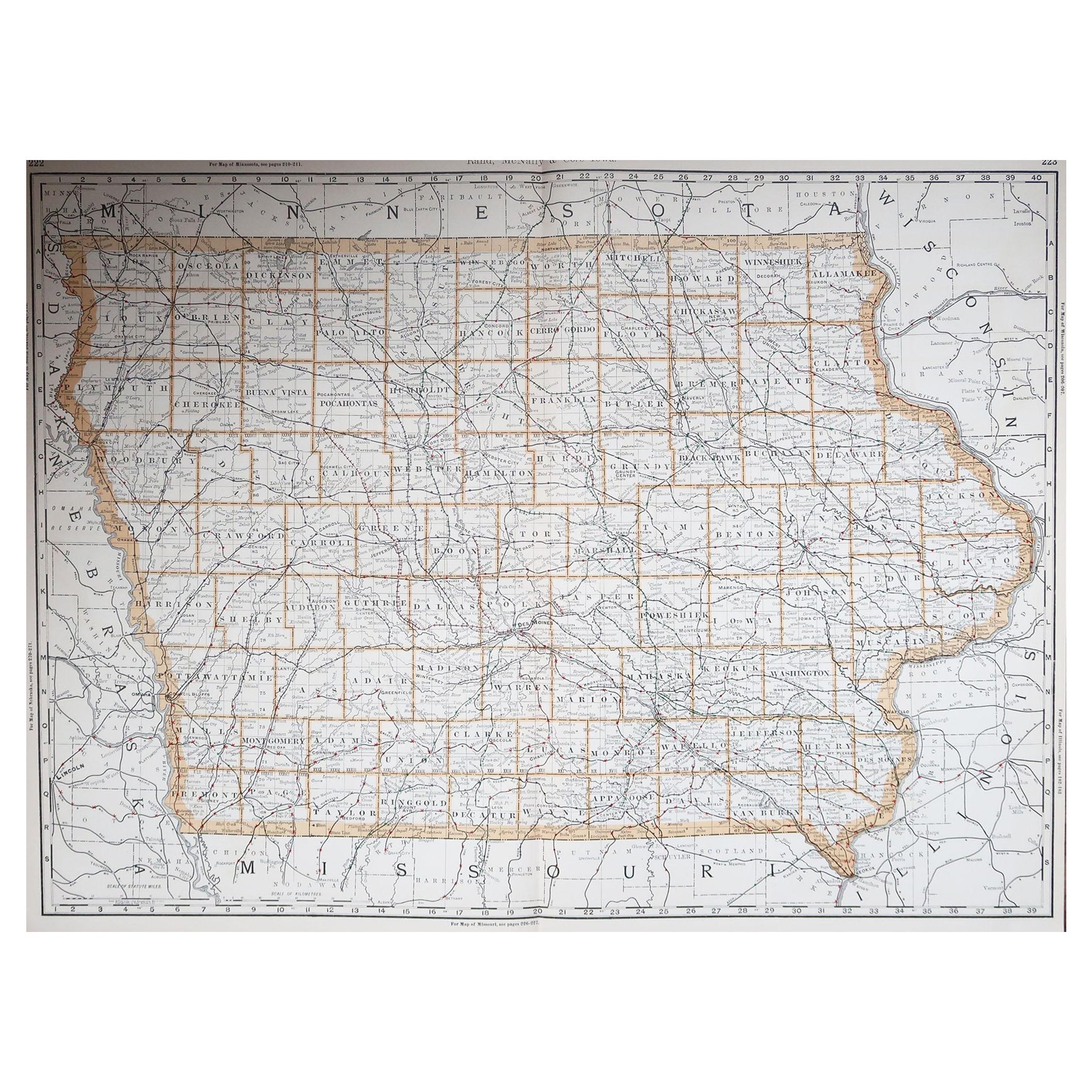
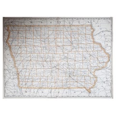
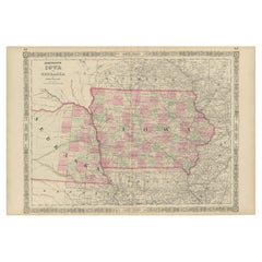
Large Original Antique Map of Iowa, USA, 1894
By Rand McNally
Co.
Located in St Annes, Lancashire
Fabulous map of Iowa.
Original color.
By Rand, McNally & Co.
Published, 1894.
Unframed.
Free shipping.
Category
Antique 1890s American Maps
Materials
Paper
Original Antique Map of the American State of Nebraska, 1903
Located in St Annes, Lancashire
Antique map of Nebraska
Published By A & C Black. 1903
Original colour
Good condition
Unframed.
Free shipping
Category
Antique Early 1900s English Maps
Materials
Paper

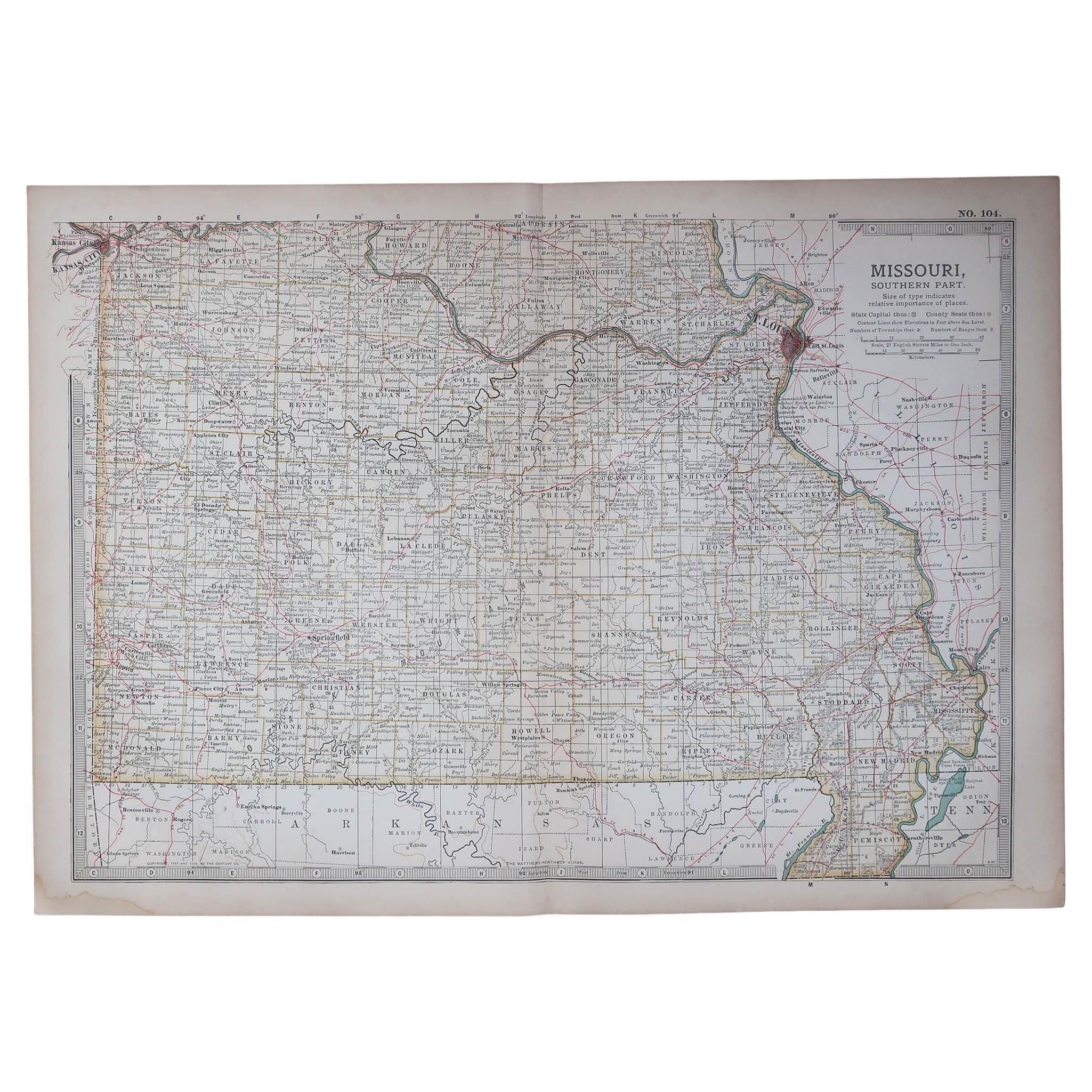
Original Antique Map of the American State of Missouri ( Southern part ), 1903
Located in St Annes, Lancashire
Antique map of Missouri ( Southern Part )
Published By A & C Black. 1903
Original colour
Good condition
Unframed.
Free shipping
Category
Antique Early 1900s English Maps
Materials
Paper

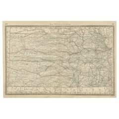
Original Antique Map of South Dakota by Rand McNally, circa 1900
By Rand McNally
Co.
Located in St Annes, Lancashire
Fabulous monochrome map with red outline color
Original color
By Rand, McNally & Co.
Published, circa 1900
Unframed
Minor edge tears.
Category
Antique Early 1900s American Edwardian Maps
Materials
Paper

You May Also Like
Kansas, United States of America, Century Atlas state antique vintage map
Located in Melbourne, Victoria
'The Century Atlas. Kansas.'
Original antique map, 1903.
Central fold as issued. Map name and number printed on the reverse corners.
Sheet 29.5cm by 40cm.
Category
Early 20th Century Victorian More Prints
Materials
Lithograph
Antique Map of Nebraska
Located in Langweer, NL
Antique map titled 'Nebraska'. Original antique map of Nebraska, United States. This print originates from 'Encyclopaedia Britannica', Ninth Edition. Pu...
Category
Antique Late 19th Century Maps
Materials
Paper

$275 Sale Price
20% Off
Antique Map of Iowa and Nebraska by Johnson,
1872
Located in Langweer, NL
Antique map titled 'Johnson's Iowa and Nebraska'. Original map of Iowa and Nebraska. This map originates from 'Johnson's New Illustrated Family Atlas of th...
Category
Antique Late 19th Century Maps
Materials
Paper

Kansas Railroad Map 1888 – Rand McNally Antique Lithograph
Located in Langweer, NL
Kansas Railroad Map 1888 – Rand McNally Antique Lithograph
This antique 1888 map of Kansas by Rand, McNally & Co. offers a detailed view of the state during a period of rapid expans...
Category
Antique Late 19th Century American Maps
Materials
Paper
Nebraska. USA. Century Atlas state antique vintage map
Located in Melbourne, Victoria
'The Century Atlas. Nebraska.'
Original antique map, 1903.
Central fold as issued. Map name and number printed on the reverse corners.
Sheet 29.5cm by 40cm.
Category
Early 20th Century Victorian More Prints
Materials
Lithograph
Vintage 1862 Map of Iowa and Nebraska – Decorative Atlas Print
Located in Langweer, NL
Antique Map of Iowa and Nebraska by Johnson and Ward, 1862
This beautifully detailed antique map, published in 1862, depicts the states of Iowa and Nebraska during the mid-19th cent...
Category
Antique 1860s Maps
Materials
Paper
More Ways To Browse
Map Tuscany
St Eustatius
Sumba Map
Used Furniture Denver Co
Used Furniture Leominster
Vintage Long Island Map
Vintage World Map Desk
Vintage World Map Mirror
Antique Furniture Toledo Ohio
Antique Maps Washington Dc
Blaeu World Map
Cape Cod Map
F Colton
Irish Antiques 16th Century
Ithaca Antique Map
Leonard Jones
Russia Globe
Salt Lake City Used Furniture