Items Similar to Large Original Antique Map of North Dakota, USA, circa 1900

Want more images or videos?
Request additional images or videos from the seller
1 of 5
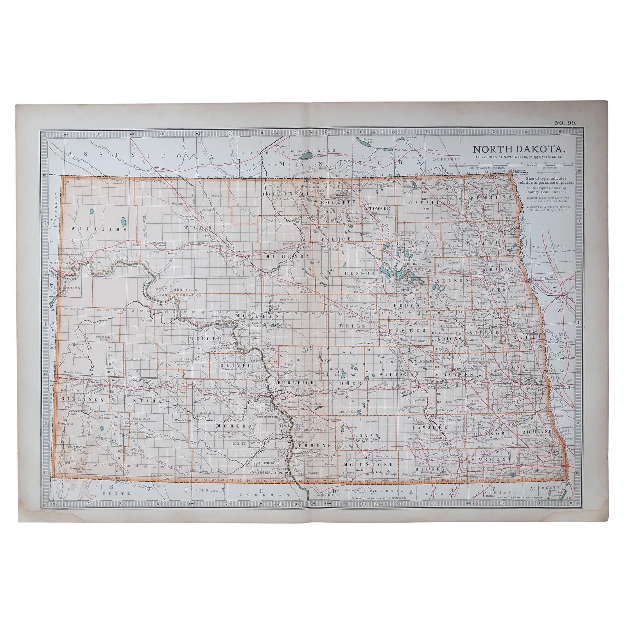
Large Original Antique Map of North Dakota, USA, circa 1900
$90
£68.53
€78.91
CA$127.54
A$137.19
CHF 73.32
MX$1,617.02
NOK 924.34
SEK 845.02
DKK 589.62
About the Item
Fabulous map of North Dakota
Original color
Engraved and printed by the George F. Cram Company, Indianapolis.
Published, circa 1900
Unframed
Free shipping.
- Dimensions:Height: 14.5 in (36.83 cm)Width: 22 in (55.88 cm)Depth: 0.07 in (1.78 mm)
- Materials and Techniques:Paper,Other
- Place of Origin:
- Period:
- Date of Manufacture:1900
- Condition:Wear consistent with age and use.
- Seller Location:St Annes, GB
- Reference Number:1stDibs: LU1836332733172
About the Seller
4.9
Gold Seller
Premium sellers maintaining a 4.3+ rating and 24-hour response times
1stDibs seller since 2016
3,281 sales on 1stDibs
Typical response time: 1 hour
Associations
International Confederation of Art and Antique Dealers
Associations
- ShippingRetrieving quote...Shipping from: St Annes, United Kingdom
- Return Policy
More From This Seller
View AllOriginal Antique Map of the American State of North Dakota, 1903
Located in St Annes, Lancashire
Antique map of North Dakota
Published By A & C Black. 1903
Original colour
Good condition
Unframed.
Free shipping
Category
Antique Early 1900s English Maps
Materials
Paper
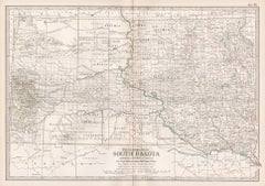
Original Antique Map of the American State of South Dakota, 1903
Located in St Annes, Lancashire
Antique map of South Dakota
Published By A & C Black. 1903
Original colour
Good condition
Unframed.
Free shipping
Category
Antique Early 1900s English Maps
Materials
Paper

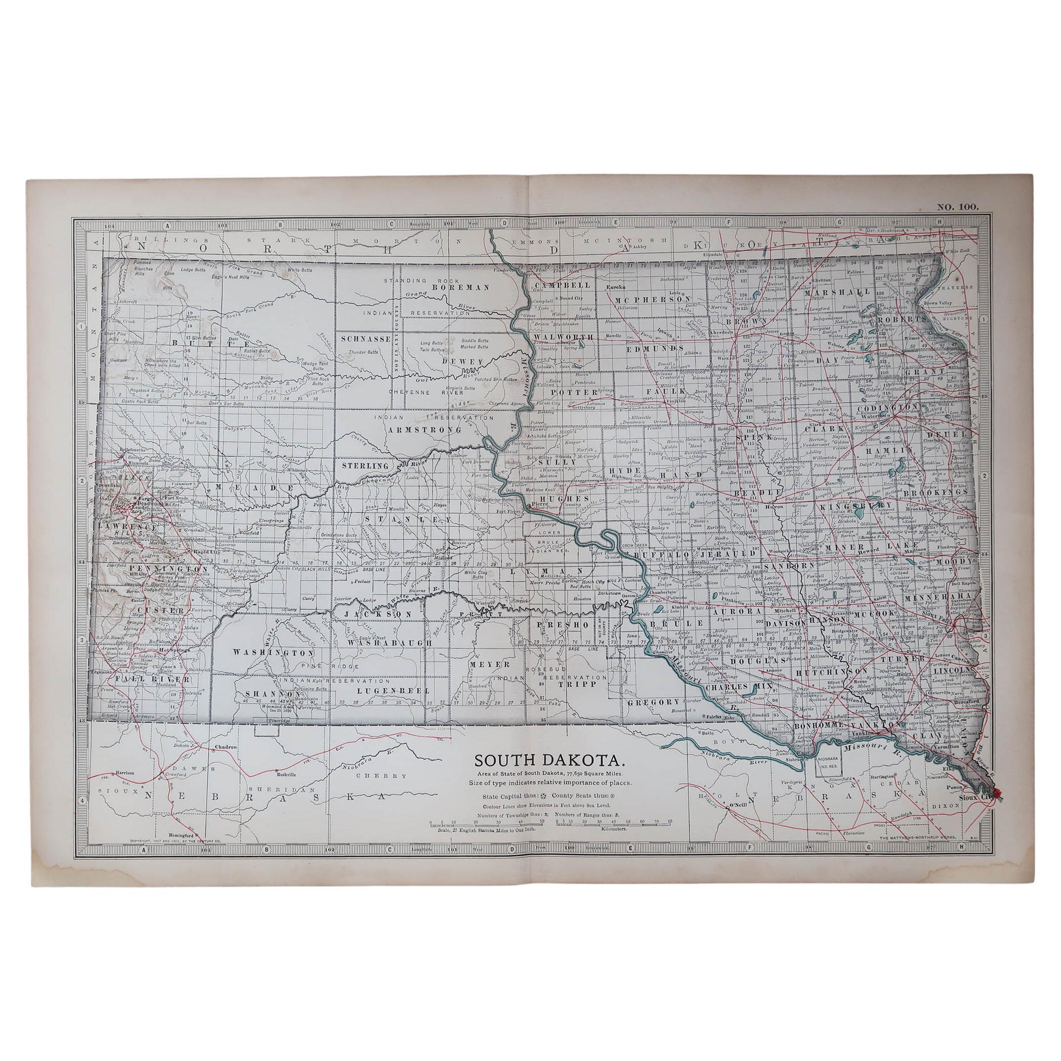
Original Antique Map of South Dakota by Rand McNally, circa 1900
By Rand McNally
Co.
Located in St Annes, Lancashire
Fabulous monochrome map with red outline color
Original color
By Rand, McNally & Co.
Published, circa 1900
Unframed
Minor edge tears.
Category
Antique Early 1900s American Edwardian Maps
Materials
Paper

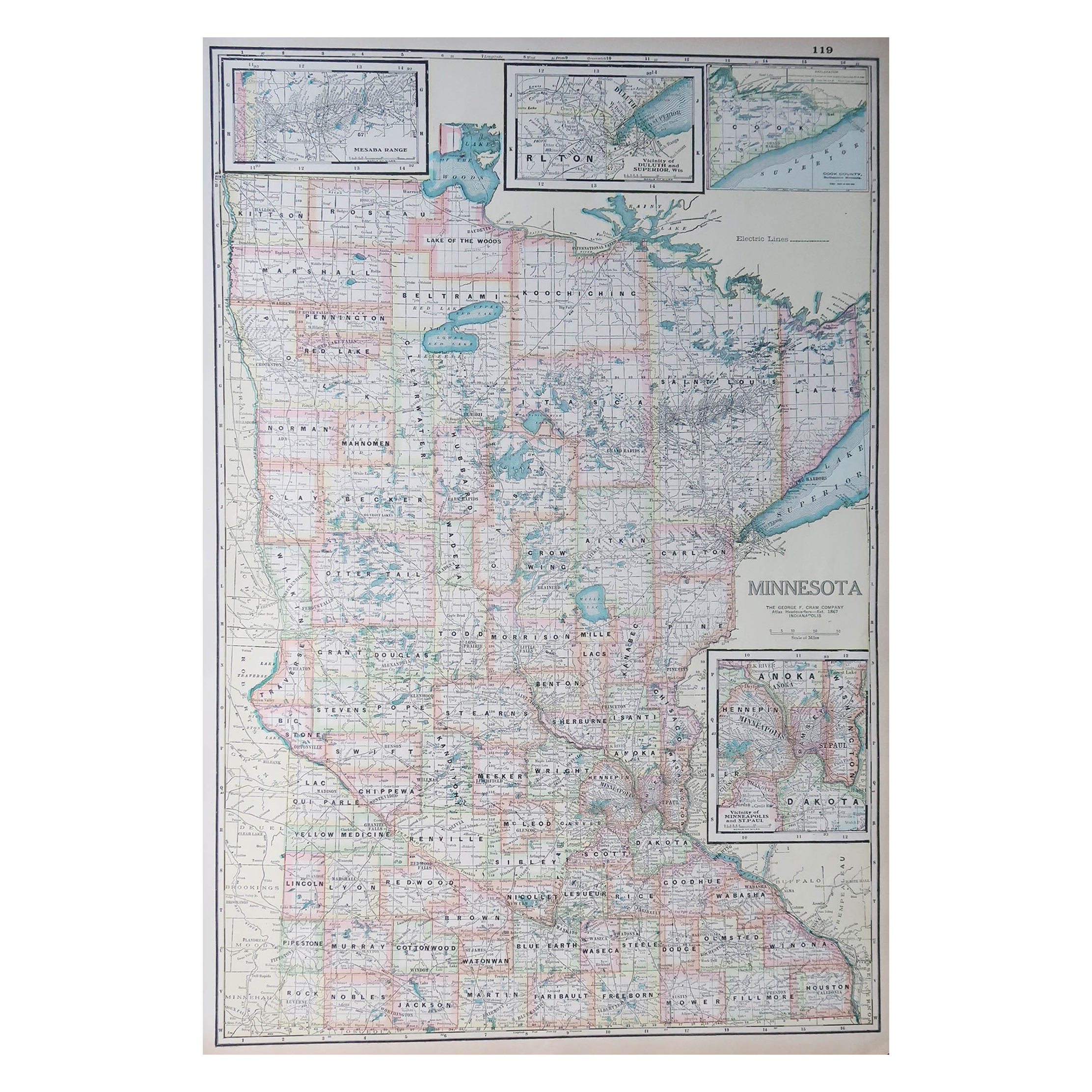
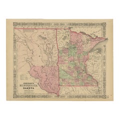
Large Original Antique Map of Minnesota, USA, C.1900
Located in St Annes, Lancashire
Fabulous map of Minnesota
Original color
Engraved and printed by the George F. Cram Company, Indianapolis.
Published, C.1900
Unframed
Repair to a small tear bottom left corner
...
Category
Antique 1890s American Maps
Materials
Paper
Original Antique Map of the American State of Nebraska, 1903
Located in St Annes, Lancashire
Antique map of Nebraska
Published By A & C Black. 1903
Original colour
Good condition
Unframed.
Free shipping
Category
Antique Early 1900s English Maps
Materials
Paper

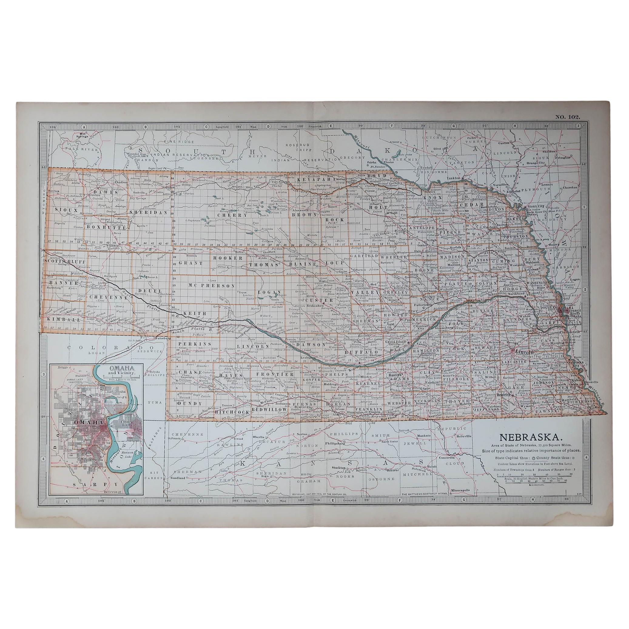
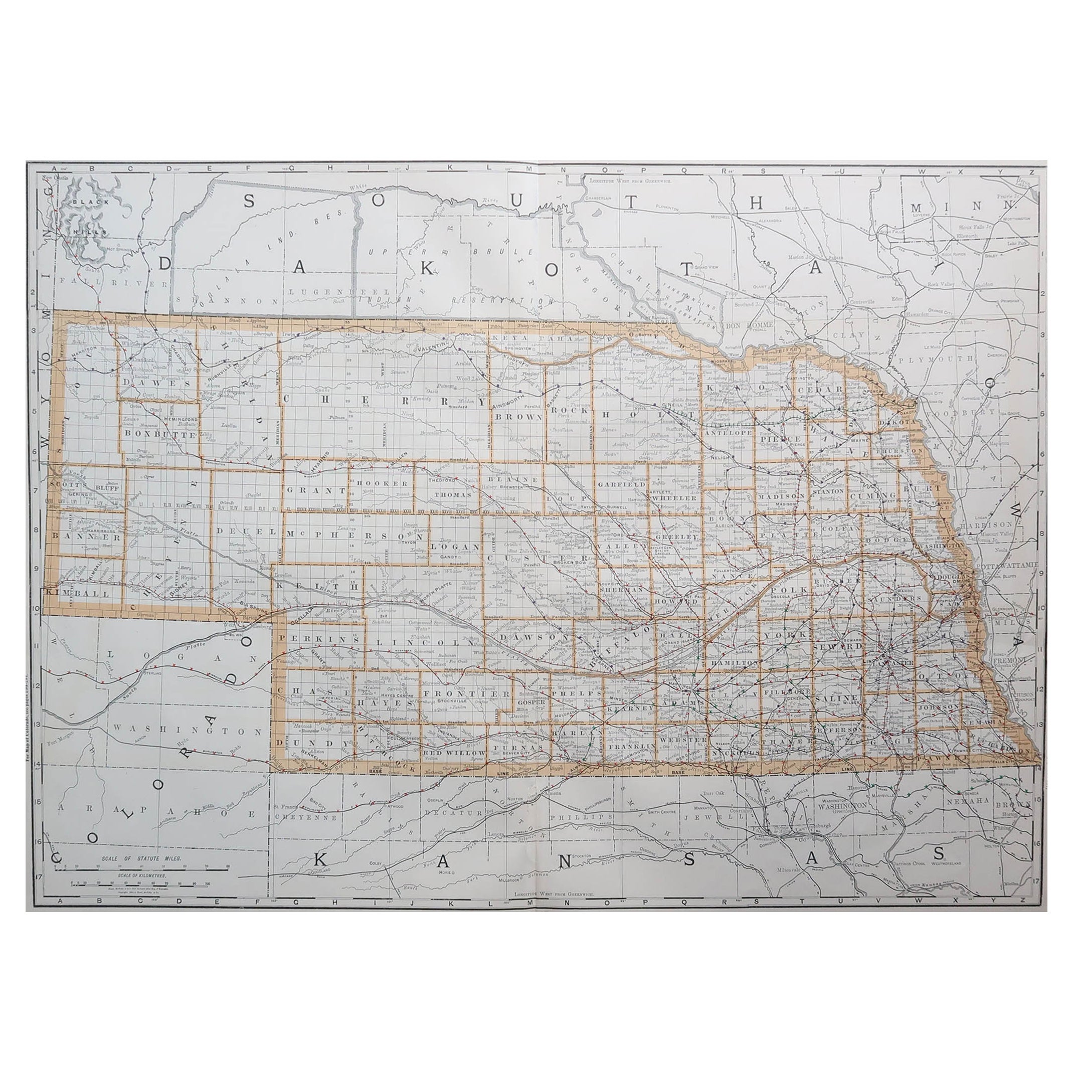
Large Original Antique Map of Nebraska, USA, 1894
By Rand McNally
Co.
Located in St Annes, Lancashire
Fabulous map of Nebraska
Original color
By Rand, McNally & Co.
Published, 1894
Unframed
Some slight restoration to the Gosper / Furnas area. Seen in the last image
Free shipping.
Category
Antique 1890s American Maps
Materials
Paper
You May Also Like
South Dakota. USA. Century Atlas state antique vintage map
Located in Melbourne, Victoria
'The Century Atlas. South Dakota.'
Original antique map, 1903.
Central fold as issued. Map name and number printed on the reverse corners.
Sheet 29.5cm ...
Category
Early 20th Century Victorian More Prints
Materials
Lithograph
Antique Map of Nebraska
Located in Langweer, NL
Antique map titled 'Nebraska'. Original antique map of Nebraska, United States. This print originates from 'Encyclopaedia Britannica', Ninth Edition. Pu...
Category
Antique Late 19th Century Maps
Materials
Paper

$275 Sale Price
20% Off
Antique Map of the United States
North West
by Johnston,
1909
Located in Langweer, NL
Antique map titled 'United States of North America'. Original antique map of the United States of North America ( North West ). This map originates from the ‘Royal Atlas of Modern Ge...
Category
Early 20th Century Maps
Materials
Paper

$237 Sale Price
20% Off
Antique Map of the United States
North East
by Johnston
1909
Located in Langweer, NL
Antique map titled 'United States of North America'. Original antique map of United States of North America ( North East ). This map orig...
Category
Early 20th Century Maps
Materials
Paper

$237 Sale Price
20% Off
1890 "Map of Oregon, Kansas, California, and the Territories" by S. A. Mitchell
By Samuel Augustus Mitchell 1
Located in Colorado Springs, CO
Presented is an 1890 map "Map of Oregon, Kansas, California, and the Territories" by S. A. Mitchell Jr. The map was issued in the atlas “Mitchell's New Intermediate Geography” publis...
Category
Antique 1890s American Victorian Maps
Materials
Paper

Minnesota and Dakota Map – Johnson, Hand-Colored, USA c.1864
Located in Langweer, NL
Johnson’s Minnesota and Dakota Map, USA c.1864 – Hand-Colored Territorial Map
Description:
This is a finely engraved and hand-colored map titled Johnson’s Minnesota and Dakota, pub...
Category
Antique Mid-19th Century American Maps
Materials
Paper
More Ways To Browse
Map New Holland
Mauritius Antique Map
Nantucket Poster
Nicolas Baier
Ruben Benjamin
Washington Dc Map
Wood Carved Golfer
1681 Moses Pitt
Antique Map Bermuda
Antique Map Of Brooklyn
Antique Map Of Republic Of Texas
Extra Large Map
George Weymouth
Georgetown Map
Hemisphere Antiques
J Matthews
Japanese Kite
Maltese Falcon